May, Texas
Submit your own pictures of this place and show them to the world
- OSM Map
- General Map
- Google Map
- MSN Map

| Males: 983 | |
| Females: 959 |
| Median resident age: | 48.1 years |
| Texas median age: | 32.3 years |
Zip code: 76857
| May: | $53,483 |
| TX: | $72,284 |
Estimated per capita income in 2022: $32,851 (it was $16,723 in 2000)
May CCD income, earnings, and wages data
Estimated median house or condo value in 2022: $154,926 (it was $46,700 in 2000)
| May: | $154,926 |
| TX: | $275,400 |
Mean prices in 2022: all housing units: $231,763; detached houses: $253,190; townhouses or other attached units: $312,668; in 2-unit structures: $213,620; mobile homes: $108,578; occupied boats, rvs, vans, etc.: $20,029
Detailed information about poverty and poor residents in May, TX


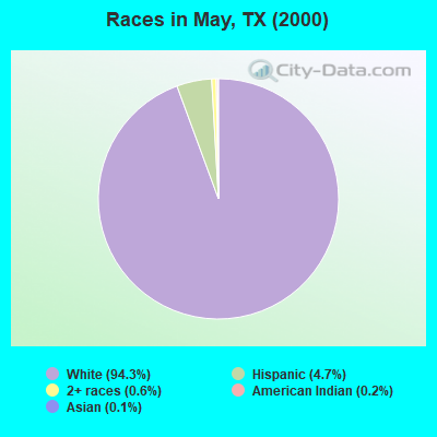
- 1,80794.3%White alone
- 904.7%Hispanic
- 120.6%Two or more races
- 40.2%American Indian alone
- 20.1%Asian alone
- 10.05%Black alone
Races in May detailed stats: ancestries, foreign born residents, place of birth
According to our research of Texas and other state lists, there were 8 registered sex offenders living in May, Texas as of May 09, 2024.
The ratio of all residents to sex offenders in May is 243 to 1.
 Recent articles from our blog. Our writers, many of them Ph.D. graduates or candidates, create easy-to-read articles on a wide variety of topics.
Current Local Time: CST time zone
Land area: 237.1 square miles.
Population density: 8.2 people per square mile (very low).

| May CCD: | 0.8% ($368) |
| Texas: | 1.8% ($1,393) |
Nearest city with pop. 50,000+: Abilene, TX  (52.7 miles , pop. 115,930).
Nearest city with pop. 200,000+: Fort Worth, TX (111.9 miles , pop. 534,694).
Nearest city with pop. 1,000,000+: Dallas, TX (142.5 miles , pop. 1,188,580).
Nearest cities:
), ), ), Latitude: 31.98 N, Longitude: 99.03 W
Area code: 254

| Here: | 3.6% |
| Texas: | 3.5% |
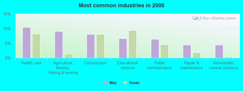
- Health care (10.5%)
- Agriculture, forestry, fishing & hunting (9.2%)
- Construction (8.1%)
- Educational services (6.6%)
- Public administration (6.5%)
- Repair & maintenance (4.4%)
- Nonmetallic mineral products (4.4%)
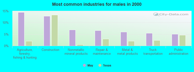
- Agriculture, forestry, fishing & hunting (14.4%)
- Construction (12.8%)
- Nonmetallic mineral products (6.9%)
- Repair & maintenance (6.7%)
- Metal & metal products (6.0%)
- Truck transportation (5.5%)
- Public administration (5.0%)
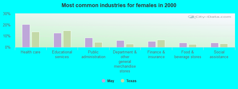
- Health care (20.5%)
- Educational services (12.7%)
- Public administration (8.5%)
- Department & other general merchandise stores (6.2%)
- Finance & insurance (5.2%)
- Food & beverage stores (3.9%)
- Social assistance (3.9%)
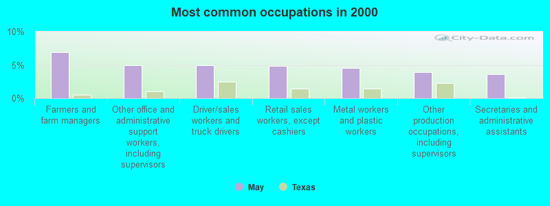
- Farmers and farm managers (6.9%)
- Other office and administrative support workers, including supervisors (5.0%)
- Driver/sales workers and truck drivers (5.0%)
- Retail sales workers, except cashiers (4.8%)
- Metal workers and plastic workers (4.6%)
- Other production occupations, including supervisors (3.9%)
- Secretaries and administrative assistants (3.6%)
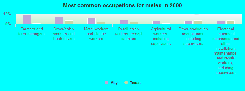
- Farmers and farm managers (10.6%)
- Driver/sales workers and truck drivers (8.5%)
- Metal workers and plastic workers (7.8%)
- Retail sales workers, except cashiers (4.8%)
- Agricultural workers, including supervisors (3.9%)
- Other production occupations, including supervisors (3.9%)
- Electrical equipment mechanics and other installation, maintenance, and repair workers, including supervisors (3.9%)
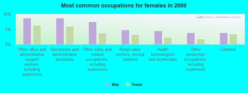
- Other office and administrative support workers, including supervisors (8.8%)
- Secretaries and administrative assistants (8.8%)
- Other sales and related occupations, including supervisors (7.5%)
- Retail sales workers, except cashiers (4.9%)
- Health technologists and technicians (4.6%)
- Other production occupations, including supervisors (3.9%)
- Cashiers (3.9%)
Average climate in May, Texas
Based on data reported by over 4,000 weather stations


Tornado activity:
May-area historical tornado activity is near Texas state average. It is 32% greater than the overall U.S. average.
On 4/19/1976, a category F5 (max. wind speeds 261-318 mph) tornado 12.8 miles away from the May place center injured 11 people and caused between $500,000 and $5,000,000 in damages.
On 4/19/1976, a category F3 (max. wind speeds 158-206 mph) tornado 10.6 miles away from the place center .
Earthquake activity:
May-area historical earthquake activity is significantly above Texas state average. It is 360% greater than the overall U.S. average.On 6/16/1978 at 11:46:54, a magnitude 5.3 (4.4 MB, 4.6 UK, 5.3 ML, Class: Moderate, Intensity: VI - VII) earthquake occurred 124.5 miles away from the city center
On 11/6/2011 at 03:53:10, a magnitude 5.7 (5.7 MW, Depth: 3.2 mi) earthquake occurred 277.8 miles away from May center
On 4/14/1995 at 00:32:56, a magnitude 5.7 (5.6 MB, 5.7 MS, 5.7 MW, Depth: 11.1 mi) earthquake occurred 282.6 miles away from the city center
On 9/3/2016 at 12:02:44, a magnitude 5.8 (5.8 MW, Depth: 3.5 mi) earthquake occurred 329.8 miles away from May center
On 1/2/1992 at 11:45:35, a magnitude 5.0 (4.6 MB, 5.0 LG, Depth: 3.1 mi) earthquake occurred 239.7 miles away from the city center
On 9/11/2011 at 12:27:44, a magnitude 4.3 (4.3 MW, Depth: 3.1 mi, Class: Light, Intensity: IV - V) earthquake occurred 117.9 miles away from the city center
Magnitude types: regional Lg-wave magnitude (LG), body-wave magnitude (MB), local magnitude (ML), surface-wave magnitude (MS), moment magnitude (MW)
Natural disasters:
The number of natural disasters in Brown County (17) is near the US average (15).Major Disasters (Presidential) Declared: 8
Emergencies Declared: 6
Causes of natural disasters: Storms: 8, Floods: 7, Fires: 5, Tornadoes: 4, Hurricanes: 3, Wind: 1, Other: 1 (Note: some incidents may be assigned to more than one category).
Colleges/universities with over 2000 students nearest to May:
- Cisco College (about 29 miles; Cisco, TX; Full-time enrollment: 2,687)
- Tarleton State University (about 51 miles; Stephenville, TX; FT enrollment: 8,882)
- Abilene Christian University (about 53 miles; Abilene, TX; FT enrollment: 4,025)
- Weatherford College (about 90 miles; Weatherford, TX; FT enrollment: 4,080)
- Angelo State University (about 93 miles; San Angelo, TX; FT enrollment: 6,019)
- Central Texas College (about 94 miles; Killeen, TX; FT enrollment: 15,911)
- Texas Christian University (about 110 miles; Fort Worth, TX; FT enrollment: 9,131)
Public elementary/middle school in May:
- MAY EL (Students: 104, Location: 3400 CR 411 E, Grades: PK-6)
Points of interest:
Notable locations in May: May Volunteer Fire Department (A), North Lake Brownwood Volunteer Fire Department and Emergency Medical Services (B). Display/hide their locations on the map
Churches in May include: Union Grove Church (A), Wolf Valley Church (B), Blake Church (C). Display/hide their locations on the map
Cemeteries: Cross Cut Cemetery (1), Pleasant Valley Cemetery (2), May Cemetery (3), Lost Creek Cemetery (4). Display/hide their locations on the map
Reservoirs: Soil Conservation Service Site 34 Reservoir (A), Soil Conservation Service Site 12 Reservoir (B), Soil Conservation Service Site 11a Reservoir (C), Soil Conservation Service Site 26 Reservoir (D), Soil Conservation Service Site 10 Reservoir (E), Soil Conservation Service Site 10a Reservoir (F), Soil Conservation Service Site 32 Reservoir (G), Soil Conservation Service Site 31 Reservoir (H). Display/hide their locations on the map
Streams, rivers, and creeks: Bledsoe Branch (A), Turkey Creek (B), Rough Branch (C), Red River (D), Pasture Branch (E), Paint Creek (F), Lost Creek (G), Hay Branch (H), Hog Creek (I). Display/hide their locations on the map
| This place: | 2.3 people |
| Texas: | 2.8 people |
| This place: | 70.2% |
| Whole state: | 69.9% |
| This place: | 3.9% |
| Whole state: | 6.0% |
Likely homosexual households (counted as self-reported same-sex unmarried-partner households)
- Lesbian couples: 0.7% of all households
- Gay men: 0.3% of all households
| This place: | 13.8% |
| Whole state: | 15.4% |
| This place: | 3.9% |
| Whole state: | 6.7% |
For population 15 years and over in May:
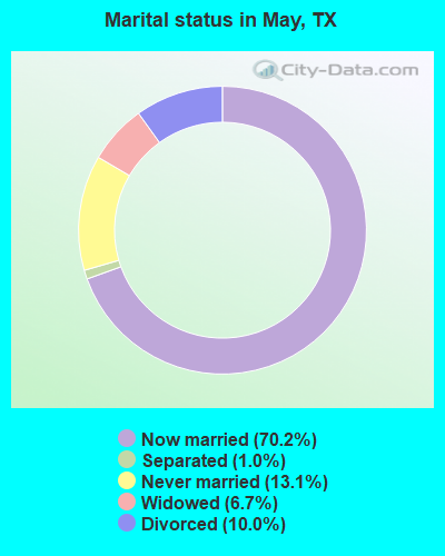
- Never married: 13.1%
- Now married: 70.2%
- Separated: 1.0%
- Widowed: 6.7%
- Divorced: 10.0%
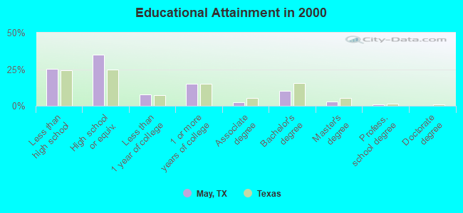
For population 25 years and over in May:
- High school or higher: 74.6%
- Bachelor's degree or higher: 14.1%
- Graduate or professional degree: 3.8%
- Unemployed: 4.9%
- Mean travel time to work (commute): 29.9 minutes
| Here: | 10.9 |
| Texas average: | 15.6 |
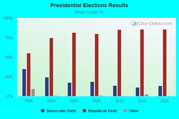
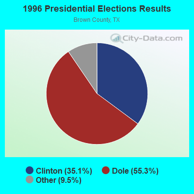
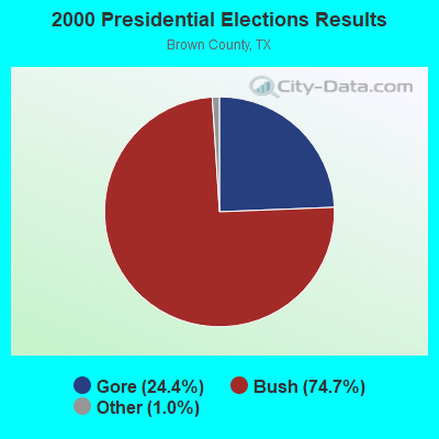
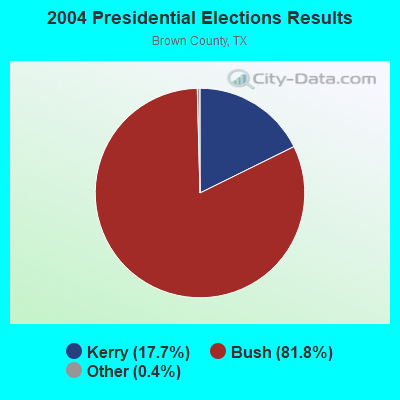
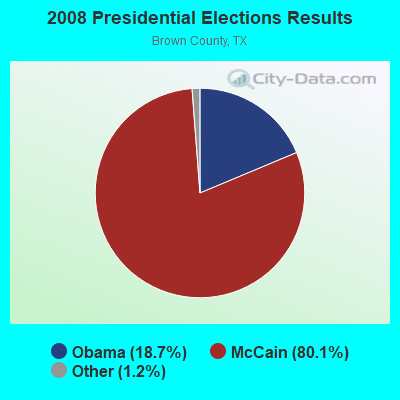
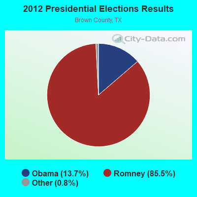
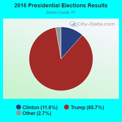

Graphs represent county-level data. Detailed 2008 Election Results
Religion statistics for May, TX (based on Brown County data)

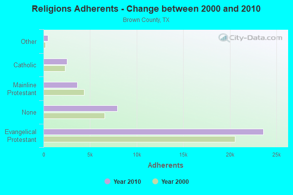
| Religion | Adherents | Congregations |
|---|---|---|
| Evangelical Protestant | 23,607 | 79 |
| Mainline Protestant | 3,609 | 12 |
| Catholic | 2,500 | 1 |
| Other | 458 | 3 |
| Black Protestant | 37 | 1 |
| None | 7,895 | - |
Food Environment Statistics:
| This county: | 1.83 / 10,000 pop. |
| State: | 1.47 / 10,000 pop. |
| Brown County: | 0.26 / 10,000 pop. |
| Texas: | 0.14 / 10,000 pop. |
| Brown County: | 0.78 / 10,000 pop. |
| Texas: | 1.11 / 10,000 pop. |
| Brown County: | 9.41 / 10,000 pop. |
| Texas: | 3.95 / 10,000 pop. |
| Here: | 8.36 / 10,000 pop. |
| Texas: | 6.13 / 10,000 pop. |
| Brown County: | 9.4% |
| Texas: | 8.9% |
| Here: | 25.1% |
| Texas: | 26.6% |
| Brown County: | 16.2% |
| Texas: | 15.7% |
Strongest AM radio stations in May:
- WBAP (820 AM; 50 kW; FORT WORTH, TX; Owner: WBAP-KSCS OPERATING, LTD.)
- KAHZ (1360 AM; 50 kW; HURST, TX)
- KESS (1270 AM; 50 kW; FORT WORTH, TX; Owner: KESS-AM LICENSE CORP.)
- KKYX (680 AM; 50 kW; SAN ANTONIO, TX; Owner: CXR HOLDINGS, INC.)
- KXYL (1240 AM; 1 kW; BROWNWOOD, TX; Owner: WATTS COMMUNICATIONS, INC.)
- KRLD (1080 AM; 50 kW; DALLAS, TX; Owner: TEXAS INFINITY BROADCASTING L.P.)
- KBWD (1380 AM; 1 kW; BROWNWOOD, TX; Owner: BROWN COUNTY BROADCASTING CO.)
- KTKR (760 AM; 50 kW; SAN ANTONIO, TX; Owner: CCB TEXAS LICENSES, L.P.)
- KZMP (1540 AM; 50 kW; UNIVERSITY PARK, TX; Owner: ENTRAVISION HOLDINGS, LLC)
- KFXR (1190 AM; 50 kW; DALLAS, TX; Owner: CLEAR CHANNEL BROADCASTING LICENSES, INC.)
- KSKY (660 AM; 20 kW; BALCH SPRINGS, TX; Owner: BISON MEDIA, INC.)
- WOAI (1200 AM; 50 kW; SAN ANTONIO, TX; Owner: CCB TEXAS LICENSES, L.P.)
- KEAN (1470 AM; 5 kW; ABILENE, TX; Owner: CCB TEXAS LICENSES, L.P.)
Strongest FM radio stations in May:
- KOXE (101.3 FM; BROWNWOOD, TX; Owner: BROWN COUNTY BROADCASTING CO.)
- KHPU (91.7 FM; BROWNWOOD, TX; Owner: HOWARD PAYNE UNIVERSITY)
- KYOX (94.3 FM; COMANCHE, TX; Owner: 377 BROADCASTING, INC)
- KXYL-FM (96.9 FM; BROWNWOOD, TX; Owner: WATTS COMMUNICATIONS, INC.)
- KXCT (102.3 FM; COLEMAN, TX; Owner: WATTS COMMUNICATIONS, INC.)
- KPSM (99.3 FM; BROWNWOOD, TX; Owner: LIVING WORD CHURCH OF BROWNWOOD, INC.)
- KPBE (89.3 FM; BROWNWOOD, TX; Owner: PAULINO BERNAL EVANGELISM)
- KBUB (90.3 FM; BROWNWOOD, TX; Owner: LIVING WORD CHURCH OF BROWNWOOD, INC)
- KEYJ-FM (107.9 FM; ABILENE, TX; Owner: CCB TEXAS LICENSES, L.P.)
- KNCE (95.1 FM; BAIRD, TX; Owner: DOUD MEDIA GROUP, LLC)
TV broadcast stations around May:
- K61CV (Channel 61; MULLIN, TX; Owner: MAKO COMMUNICATIONS, LLC)
- K65BC (Channel 65; MULLIN, TX; Owner: MAKO COMMUNICATIONS, LLC)
- KIDU-LP (Channel 56; BROWNWOOD, TX; Owner: SAGE BROADCASTING CORP.)
- KPTC-LP (Channel 48; CISCO, TX; Owner: PRIME TIME CHRISTIAN B/CING., INC.)
- KXVA (Channel 15; ABILENE, TX; Owner: STAR BROADCASTING LIMITED)
- K26AP (Channel 26; BROWNWOOD, TX; Owner: TRINITY BROADCASTING NETWORK)
May fatal accident list:
FCC Registered Antenna Towers:
25 (See the full list of FCC Registered Antenna Towers in May)FCC Registered Broadcast Land Mobile Towers:
1- Lat: 31.976944 Lon: -98.920472, Call Sign: WPYY259,
Assigned Frequencies: 152.315 MHz, 157.575 MHz, Grant Date: 11/28/2003, Expiration Date: 11/28/2013, Cancellation Date: 02/01/2014, Certifier: Carolyn V Gibson, Registrant: Richard R Gibson, May, TX 76857, Phone: (254) 259-2315, Fax: (254) 259-0001
FCC Registered Microwave Towers:
18 (See the full list of FCC Registered Microwave Towers in this town)FCC Registered Amateur Radio Licenses:
15 (See the full list of FCC Registered Amateur Radio Licenses in May)FAA Registered Aircraft:
2- Aircraft: BEECH V35 (Category: Land, Seats: 6, Weight: Up to 12,499 Pounds, Speed: 150 mph), Engine: CONT MOTOR IO 520 SERIES (285 HP) (Reciprocating)
N-Number: 1417B, N1417B, N-1417B, Serial Number: D-8550, Year manufactured: 1967, Airworthiness Date: 08/03/1967, Certificate Issue Date: 06/24/2015
Registrant (Individual): Scott Springfield, 4035 Choctaw Dr, May, TX 76857
Deregistered: Cancel Date: 05/30/2008, Exported to: Canada - Aircraft: CESSNA 182L (Category: Land, Seats: 4, Weight: Up to 12,499 Pounds, Speed: 119 mph), Engine: CONT MOTOR O-470 SERIES (230 HP) (Reciprocating)
N-Number: 3316R, N3316R, N-3316R, Serial Number: 18258616, Airworthiness Date: 11/22/1967, Certificate Issue Date: 04/10/2019
Registrant (Individual): Todd Hamilton, 11301 County Road 417, May, TX 76857
Deregistered: Cancel Date: 09/13/2018
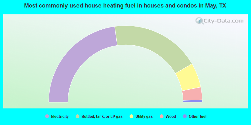
- 45.5%Electricity
- 37.8%Bottled, tank, or LP gas
- 10.4%Utility gas
- 5.3%Wood
- 1.0%Other fuel
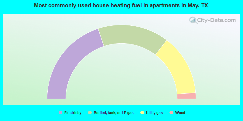
- 39.8%Electricity
- 31.0%Bottled, tank, or LP gas
- 26.5%Utility gas
- 2.7%Wood
May compared to Texas state average:
- Median house value below state average.
- Unemployed percentage significantly below state average.
- Black race population percentage significantly below state average.
- Hispanic race population percentage significantly below state average.
- Median age significantly above state average.
- Foreign-born population percentage significantly below state average.
- Renting percentage significantly below state average.
- Length of stay since moving in significantly above state average.
- Number of rooms per house significantly below state average.
- House age significantly below state average.
- Number of college students below state average.
- Percentage of population with a bachelor's degree or higher below state average.