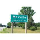
Maxville, Wisconsin
Submit your own pictures of this town and show them to the world
- OSM Map
- General Map
- Google Map
- MSN Map
Population change since 2000: -4.9%
 |
| Males: 165 | |
| Females: 144 |
| Median resident age: | 42.6 years |
| Wisconsin median age: | 42.6 years |
Zip codes: 54736.
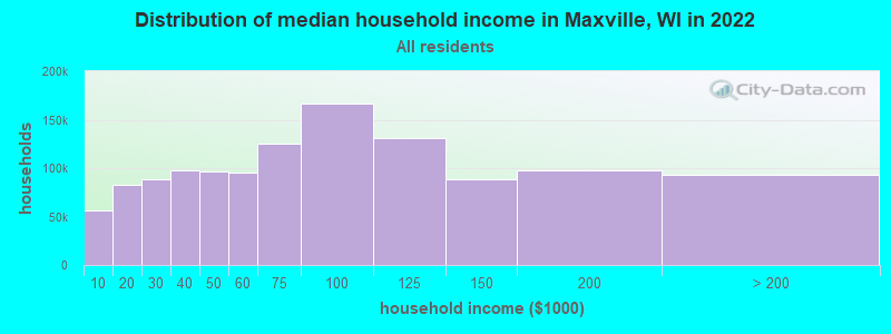
| Maxville: | $72,439 |
| WI: | $70,996 |
Estimated per capita income in 2022: $31,150 (it was $16,168 in 2000)
Maxville town income, earnings, and wages data
Estimated median house or condo value in 2022: $215,131 (it was $91,300 in 2000)
| Maxville: | $215,131 |
| WI: | $252,800 |
Detailed information about poverty and poor residents in Maxville, WI
Compare current foreclosures near Maxville, WI:
| Photo | Address | Area | Beds / Baths | Price | Details |
|---|---|---|---|---|---|

|
#1
Tanglewood Ct
Pepin, WI 54759
|
1,056 sq. feet
|
2 baths 3 beds |
show details | |

|
#2
3rd Ave E
Durand, WI 54736
|
- sq. feet
|
2 baths 3 beds |
show details | |

|
#3
Bruegger Valley Rd
Wabasha, MN 55981
|
1,452 sq. feet
|
2 baths 3 beds |
show details | |

|
#4
470th St
Menomonie, WI 54751
|
- sq. feet
|
- baths - beds |
show details | |

|
#5
Market St E
Wabasha, MN 55981
|
- sq. feet
|
- baths - beds |
show details | |

|
#6
460th Street, Apt 12
Downsville, WI 54735
|
- sq. feet
|
- baths - beds |
show details | |

|
#7
N Creek Ln
Mondovi, WI 54755
|
- sq. feet
|
- baths - beds |
show details | |

|
#8
810th St
Mondovi, WI 54755
|
- sq. feet
|
- baths - beds |
show details | |

|
#9
S Lakeshore Dr Apt 6
Lake City, MN 55041
|
- sq. feet
|
- baths - beds |
show details | |

|
#10
S Oak St
Lake City, MN 55041
|
- sq. feet
|
- baths - beds |
show details |
| Photo | Address | Area | Beds / Baths | Price | Details |
|---|---|---|---|---|---|

|
#11
Madalyn Ct
Durand, WI 54736
|
- sq. feet
|
- baths - beds |
show details | |

|
#12
6th Ave E
Durand, WI 54736
|
- sq. feet
|
- baths - beds |
show details | |

|
#13
S Main St
Elmwood, WI 54740
|
- sq. feet
|
- baths - beds |
show details | |

|
Check over 1 million property listings on Foreclosure.com!
|
browse all offers | |||

- 29996.8%White alone
- 92.9%Hispanic
- 10.3%Two or more races

Races in Maxville detailed stats: ancestries, foreign born residents, place of birth
 Recent articles from our blog. Our writers, many of them Ph.D. graduates or candidates, create easy-to-read articles on a wide variety of topics.

Latest news from Maxville, WI collected exclusively by city-data.com from local newspapers, TV, and radio stations
Ancestries: German (57.5%), Norwegian (27.4%), English (9.2%), French (4.9%), Irish (3.7%), Italian (2.5%).
Current Local Time: CST time zone
Elevation: 776 feet
Land area: 42.0 square miles.
Population density: 7.4 people per square mile (very low).
3 residents are foreign born
| This town: | 0.9% |
| Wisconsin: | 3.6% |
| Maxville town: | 1.2% ($1,104) |
| Wisconsin: | 2.0% ($2,245) |
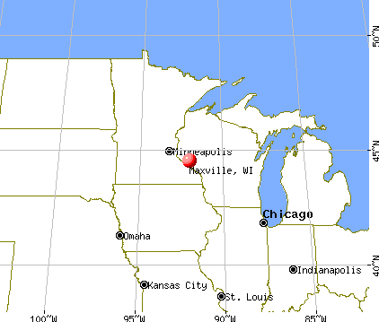
Nearest city with pop. 50,000+: Eau Claire, WI  (29.2 miles , pop. 61,704).
Nearest city with pop. 200,000+: St. Paul, MN (61.9 miles , pop. 287,151).
Nearest city with pop. 1,000,000+: Chicago, IL (287.3 miles , pop. 2,896,016).
Nearest cities:
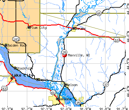
), ), ), ), Latitude: 44.57 N, Longitude: 91.98 W
Area code commonly used in this area: 715

| Here: | 4.2% |
| Wisconsin: | 2.7% |

- Agriculture, forestry, fishing & hunting (24.6%)
- Health care (9.7%)
- Construction (8.2%)
- Educational services (5.8%)
- Accommodation & food services (4.8%)
- Truck transportation (2.9%)
- Food (2.9%)

- Agriculture, forestry, fishing & hunting (34.2%)
- Construction (15.3%)
- Food (5.4%)
- Petroleum & petroleum products merchant wholesalers (5.4%)
- Educational services (5.4%)
- Motor vehicle & parts dealers (3.6%)
- Public administration (3.6%)

- Health care (18.8%)
- Agriculture, forestry, fishing & hunting (13.5%)
- Accommodation & food services (8.3%)
- Educational services (6.2%)
- Personal & laundry services (6.2%)
- Department & other general merchandise stores (4.2%)
- Printing & related support activities (4.2%)

- Farmers and farm managers (13.5%)
- Agricultural workers, including supervisors (7.7%)
- Secretaries and administrative assistants (5.3%)
- Registered nurses (4.8%)
- Cooks and food preparation workers (3.9%)
- Driver/sales workers and truck drivers (3.9%)
- Retail sales workers, except cashiers (3.9%)

- Farmers and farm managers (18.9%)
- Agricultural workers, including supervisors (10.8%)
- Construction traders workers except carpenters, electricians, painters, plumbers, and construction laborers (6.3%)
- Driver/sales workers and truck drivers (5.4%)
- Other management occupations, except farmers and farm managers (4.5%)
- Supervisors, construction and extraction workers (4.5%)
- Metal workers and plastic workers (4.5%)

- Secretaries and administrative assistants (11.5%)
- Registered nurses (10.4%)
- Cooks and food preparation workers (8.3%)
- Farmers and farm managers (7.3%)
- Building and grounds cleaning and maintenance occupations (4.2%)
- Nursing, psychiatric, and home health aides (4.2%)
- Information and record clerks, except customer service representatives (4.2%)
Average climate in Maxville, Wisconsin
Based on data reported by over 4,000 weather stations


Tornado activity:
Maxville-area historical tornado activity is near Wisconsin state average. It is 18% greater than the overall U.S. average.
On 6/4/1958, a category F5 (max. wind speeds 261-318 mph) tornado 28.7 miles away from the Maxville town center killed 21 people and injured 74 people and caused between $5,000,000 and $50,000,000 in damages.
On 5/24/1958, a category F3 (max. wind speeds 158-206 mph) tornado 3.6 miles away from the town center injured 12 people and caused between $50,000 and $500,000 in damages.
Earthquake activity:
Maxville-area historical earthquake activity is significantly above Wisconsin state average. It is 38% greater than the overall U.S. average.On 7/9/1975 at 14:54:15, a magnitude 4.6 (4.6 MB, Class: Light, Intensity: IV - V) earthquake occurred 212.4 miles away from the city center
On 6/5/1993 at 01:24:53, a magnitude 4.1 (4.1 LG, Depth: 6.2 mi) earthquake occurred 224.0 miles away from Maxville center
On 6/28/2004 at 06:10:52, a magnitude 4.2 (4.2 MW, Depth: 6.2 mi) earthquake occurred 265.4 miles away from the city center
On 4/18/2008 at 09:36:59, a magnitude 5.4 (5.1 MB, 4.8 MS, 5.4 MW, 5.2 MW, Class: Moderate, Intensity: VI - VII) earthquake occurred 473.1 miles away from the city center
On 3/4/1983 at 06:32:18, a magnitude 4.6 (4.4 MB, 4.6 LG, 4.4 ML) earthquake occurred 368.0 miles away from the city center
On 6/10/1987 at 23:48:54, a magnitude 5.1 (4.9 MB, 4.4 MS, 4.6 MS, 5.1 LG) earthquake occurred 450.2 miles away from Maxville center
Magnitude types: regional Lg-wave magnitude (LG), body-wave magnitude (MB), local magnitude (ML), surface-wave magnitude (MS), moment magnitude (MW)
Natural disasters:
The number of natural disasters in Buffalo County (14) is near the US average (15).Major Disasters (Presidential) Declared: 11
Emergencies Declared: 2
Causes of natural disasters: Floods: 10, Storms: 8, Tornadoes: 5, Heavy Rains: 2, Winds: 2, Drought: 1, Flash Flood: 1, Hurricane: 1, Landslide: 1, Other: 1 (Note: some incidents may be assigned to more than one category).

Hospitals and medical centers near Maxville:
- OAKVIEW CARE CTR (Nursing Home, about 4 miles away; DURAND, WI)
- PEPIN CTY NUR SVC (Home Health Center, about 4 miles away; DURAND, WI)
- PLUM CITY CARE CTR (Nursing Home, about 12 miles away; PLUM CITY, WI)
- MAYO DIALYSIS - WABASHA (Dialysis Facility, about 14 miles away; WABASHA, MN)
- ST ELIZABETH HOSPITAL (Hospital, about 14 miles away; WABASHA, MN)
- ST ELIZABETH HOME HEALTH CARE (Home Health Center, about 14 miles away; WABASHA, MN)
- ST ELIZABETH'S HEALTH CARE CENTER (Nursing Home, about 14 miles away; WABASHA, MN)
Colleges/universities with over 2000 students nearest to Maxville:
- University of Wisconsin-Stout (about 23 miles; Menomonie, WI; Full-time enrollment: 8,120)
- Chippewa Valley Technical College (about 28 miles; Eau Claire, WI; FT enrollment: 4,038)
- University of Wisconsin-Eau Claire (about 29 miles; Eau Claire, WI; FT enrollment: 10,143)
- University of Wisconsin-River Falls (about 38 miles; River Falls, WI; FT enrollment: 5,868)
- Saint Mary's University of Minnesota (about 39 miles; Winona, MN; FT enrollment: 4,022)
- Winona State University (about 40 miles; Winona, MN; FT enrollment: 8,397)
- Rochester Community and Technical College (about 45 miles; Rochester, MN; FT enrollment: 4,444)
Points of interest:
Notable location: Homestead Farms (A). Display/hide its location on the map
Cemetery: Maxville Cemetery (1). Display/hide its location on the map
Lake: Stump Lake (A). Display/hide its location on the map
Streams, rivers, and creeks: Spring Creek (A), Little Buffalo Slough (B). Display/hide their locations on the map
Park in Maxville: Tiffany Bottoms State Natural Area (1). Display/hide its location on the map
| This town: | 2.4 people |
| Wisconsin: | 2.4 people |
| This town: | 74.4% |
| Whole state: | 64.4% |
| This town: | 5.4% |
| Whole state: | 7.3% |
No gay or lesbian households reported
| This town: | 8.3% |
| Whole state: | 8.7% |
| This town: | 1.9% |
| Whole state: | 3.7% |
For population 15 years and over in Maxville:

- Never married: 29.5%
- Now married: 57.9%
- Separated: 0.7%
- Widowed: 5.5%
- Divorced: 6.3%
For population 25 years and over in Maxville:
- High school or higher: 91.3%
- Bachelor's degree or higher: 7.2%
- Graduate or professional degree: 2.9%
- Unemployed: 2.4%
- Mean travel time to work (commute): 26.7 minutes


| Here: | 7.4 |
| Wisconsin average: | 11.0 |
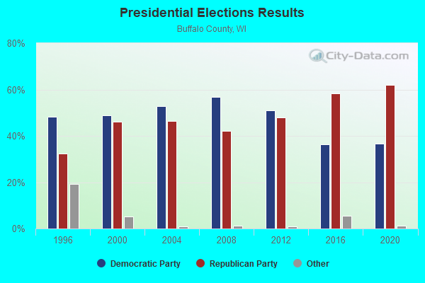
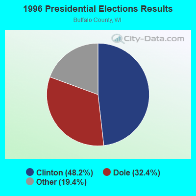
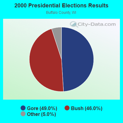
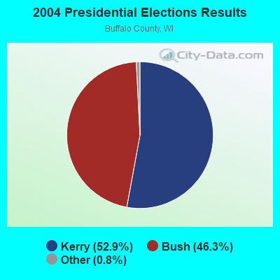
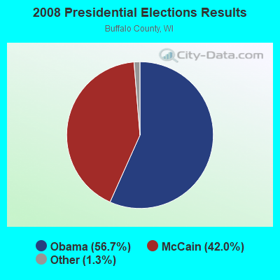
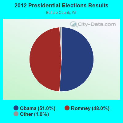
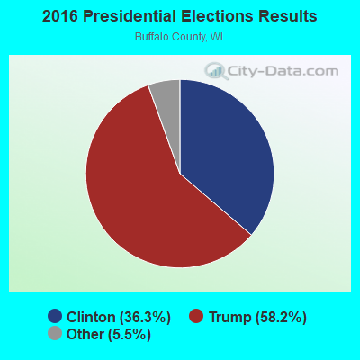
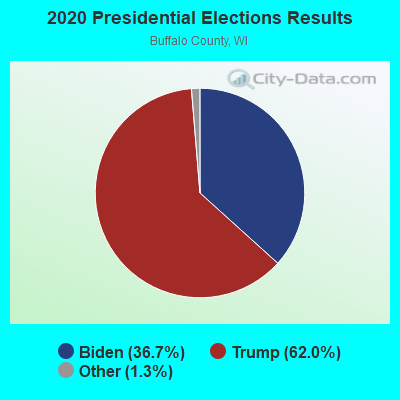
Graphs represent county-level data. Detailed 2008 Election Results
Religion statistics for Maxville, WI (based on Buffalo County data)
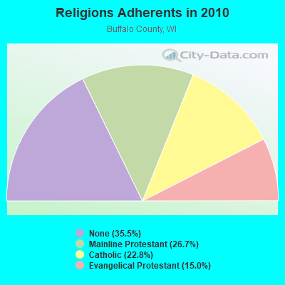
| Religion | Adherents | Congregations |
|---|---|---|
| Mainline Protestant | 3,625 | 14 |
| Catholic | 3,100 | 4 |
| Evangelical Protestant | 2,043 | 15 |
| Other | 1 | 2 |
| None | 4,818 | - |
Food Environment Statistics:
| Buffalo County: | 2.17 / 10,000 pop. |
| State: | 1.86 / 10,000 pop. |
| This county: | 5.79 / 10,000 pop. |
| State: | 4.12 / 10,000 pop. |
| Buffalo County: | 13.02 / 10,000 pop. |
| State: | 8.64 / 10,000 pop. |
| This county: | 8.5% |
| State: | 7.6% |
| This county: | 28.4% |
| State: | 27.5% |
| This county: | 13.3% |
| Wisconsin: | 13.0% |
Strongest AM radio stations in Maxville:
- WQOQ (1430 AM; 2 kW; DURAND, WI; Owner: ZOE COMMUNICATIONS, INC.)
- WMEQ (880 AM; 10 kW; MENOMONIE, WI; Owner: CAPSTAR TX LIMITED PARTNERSHIP)
- WCTS (1030 AM; 50 kW; MAPLEWOOD, MN; Owner: CNTL. BAPT. THEO/AL SEMI MINNEAPOLIS)
- WCCO (830 AM; 50 kW; MINNEAPOLIS, MN; Owner: INFINITY MEDIA CORPORATION)
- KSTP (1500 AM; 50 kW; ST. PAUL, MN; Owner: KSTP-AM, LLC (DELAWARE))
- KFAN (1130 AM; 50 kW; MINNEAPOLIS, MN; Owner: AMFM RADIO LICENSES, L.L.C.)
- KTIS (900 AM; 25 kW; MINNEAPOLIS, MN; Owner: NORTHWESTERN COLLEGE)
- WDGY (630 AM; 8 kW; HUDSON, WI; Owner: 630 RADIO, INCORPORATED)
- WAYY (790 AM; 5 kW; EAU CLAIRE, WI; Owner: MAVERICK MEDIA OF EAU CLAIRE LICENSE LLC)
- WEBC (560 AM; 50 kW; DULUTH, MN)
- WSPT (1010 AM; 50 kW; STEVENS POINT, WI)
- KMFX (1190 AM; daytime; 1 kW; WABASHA, MN; Owner: CLEAR CHANNEL BROADCASTING LICENSES, INC.)
- WEAQ (1150 AM; 5 kW; CHIPPEWA FALLS, WI; Owner: MAVERICK MEDIA OF EAU CLAIRE LICENSE LLC)
Strongest FM radio stations in Maxville:
- WDMO (95.9 FM; DURAND, WI; Owner: ZOE COMMUNICATIONS, INC.)
- KWNG (105.9 FM; RED WING, MN; Owner: SORENSON BROADCASTING CORPORATION)
- KMFX-FM (102.5 FM; LAKE CITY, MN; Owner: CLEAR CHANNEL BROADCASTING LICENSES, INC.)
- KLCH (94.9 FM; LAKE CITY, MN; Owner: WAITT RADIO, INC.)
- WHWC (88.3 FM; MENOMONIE, WI; Owner: STATE OF WISCONSIN - EDUCATIONAL COMMUNICATIONS BOARD)
- WAXX (104.5 FM; EAU CLAIRE, WI; Owner: MAVERICK MEDIA OF EAU CLAIRE LICENSE LLC)
- W211AY (90.1 FM; MENOMONIE, WI; Owner: CALVARY CHAPEL OF TWIN FALLS, INC.)
- KNXR (97.5 FM; ROCHESTER, MN; Owner: UNITED AUDIO CORPORATION)
- WVSS (90.7 FM; MENOMONIE, WI; Owner: BD. OF REGENTS, UNIVERSITY OF WISCONSIN SYSTEM)
- WUEC (89.7 FM; EAU CLAIRE, WI; Owner: BOARD OF REGENTS, UNIVERSITY OF WISCONSIN SYSTEM)
- KLSE-FM (91.7 FM; ROCHESTER, MN; Owner: MINNESOTA PUBLIC RADIO)
- KZSE (90.7 FM; ROCHESTER, MN; Owner: MINNESOTA PUBLIC RADIO)
- WMEQ-FM (92.1 FM; MENOMONIE, WI; Owner: CAPSTAR TX LIMITED PARTNERSHIP)
- WBIZ-FM (100.7 FM; EAU CLAIRE, WI; Owner: CAPSTAR TX LIMITED PARTNERSHIP)
- WECL (92.9 FM; ELK MOUND, WI; Owner: MAVERICK MEDIA OF EAU CLAIRE LICENSE LLC)
TV broadcast stations around Maxville:
- WHWC-TV (Channel 28; MENOMONIE, WI; Owner: STATE OF WISCONSIN - EDUCATIONAL COMMUNICATIONS BOARD)
- WQOW-TV (Channel 18; EAU CLAIRE, WI; Owner: WXOW-WQOW TELEVISION, INC.)
- WEAU-TV (Channel 13; EAU CLAIRE, WI; Owner: WEAU LICENSEE CORP.)
- WKBT (Channel 8; LA CROSSE, WI; Owner: QUEENB TELEVISION, LLC)
- K57CN (Channel 57; WABASHA, MN; Owner: HUBBARD BROADCASTING, INC.)
- KXLT-TV (Channel 47; ROCHESTER, MN; Owner: SHOCKLEY BROADCASTING, LLC)
- WEUX (Channel 48; CHIPPEWA FALLS, WI; Owner: GRANT MEDIA INC.)
- National Bridge Inventory (NBI) Statistics
- 4Number of bridges
- 16ft / 5.1mTotal length
- 5,962Total average daily traffic
- 203Total average daily truck traffic
- 6,938Total future (year 2039) average daily traffic
FCC Registered Antenna Towers:
3- GENE J KIRCHNER, S 104 Cr F (Lat: 44.581389 Lon: -91.912778), Type: 61.8, Overall height: 60.9 m, Registrant: Kirchner, Gene:kirchner, Ellen Dba , Duran-d, Phone: (715) 672-8989
- S 104 Co Rd F (Lat: 44.581389 Lon: -91.912778), Type: 61.9, Overall height: 61 m, Registrant: Kirchner, Gene:kirchner, Ellen Dba , Duran-d, Phone: (715) 672-8989
- S 104 Cr F (Lat: 44.581389 Lon: -91.912778), Type: 61.8, Overall height: 60.9 m, Registrant: Kirchner, Gene:kirchner, Ellen Dba , Duran-d, Phone: (715) 672-8989

- 51.8%Bottled, tank, or LP gas
- 27.1%Wood
- 14.1%Fuel oil, kerosene, etc.
- 7.1%Electricity

- 38.7%Bottled, tank, or LP gas
- 35.5%Fuel oil, kerosene, etc.
- 19.4%Wood
- 6.5%Electricity
Maxville compared to Wisconsin state average:
- Unemployed percentage significantly below state average.
- Black race population percentage significantly below state average.
- Hispanic race population percentage below state average.
- Foreign-born population percentage significantly below state average.
- Renting percentage significantly below state average.
- Length of stay since moving in significantly above state average.
- Number of rooms per house significantly below state average.
- House age significantly below state average.
- Number of college students below state average.
- Percentage of population with a bachelor's degree or higher significantly below state average.