Mason, West Virginia
Submit your own pictures of this town and show them to the world
- OSM Map
- General Map
- Google Map
- MSN Map
Population change since 2000: -21.0%
 |
| Males: 489 | |
| Females: 352 |
| Median resident age: | 54.6 years |
| West Virginia median age: | 42.9 years |
Zip codes: 25260.
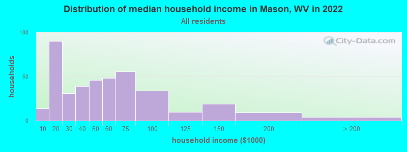
| Mason: | $45,660 |
| WV: | $54,329 |
Estimated per capita income in 2022: $26,768 (it was $14,020 in 2000)
Mason town income, earnings, and wages data
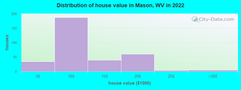
Estimated median house or condo value in 2022: $90,954 (it was $44,400 in 2000)
| Mason: | $90,954 |
| WV: | $155,100 |
Mean prices in 2022: all housing units: $96,581; detached houses: $102,931; mobile homes: $56,547
Median gross rent in 2022: $732.
(21.0% for White Non-Hispanic residents, 73.3% for two or more races residents)
Detailed information about poverty and poor residents in Mason, WV
Compare current foreclosures near Mason, WV:
| Photo | Address | Area | Beds / Baths | Price | Details |
|---|---|---|---|---|---|

|
#1
Bucktown Rd
Racine, OH 45771
|
1,728 sq. feet
|
2 baths 3 beds |
$48,000
|
show details |

|
#2
Meadowbrook Rd
Albany, OH 45710
|
1,353 sq. feet
|
1 baths 3 beds |
show details | |

|
#3
4th Ave
Gallipolis, OH 45631
|
1,020 sq. feet
|
1 baths 2 beds |
show details | |

|
#4
Ambey Ln
Vinton, OH 45686
|
1,852 sq. feet
|
2 baths 3 beds |
show details | |

|
#5
Woodsmill Rd
Bidwell, OH 45614
|
1,830 sq. feet
|
3 baths 3 beds |
show details | |

|
#6
Dutch Ridge Rd
Guysville, OH 45735
|
1,840 sq. feet
|
1 baths 3 beds |
show details | |

|
#7
Bulaville Pike
Gallipolis, OH 45631
|
1,340 sq. feet
|
2 baths 3 beds |
show details | |

|
#8
Washington Ave
Point Pleasant, WV 25550
|
1 sq. feet
|
2 baths 3 beds |
show details | |

|
#9
Bulaville Pike
Gallipolis, OH 45631
|
1,028 sq. feet
|
1 baths 3 beds |
show details | |

|
#10
Bittersweet Dr
Gallipolis, OH 45631
|
1,312 sq. feet
|
1 baths 3 beds |
show details |
| Photo | Address | Area | Beds / Baths | Price | Details |
|---|---|---|---|---|---|

|
#11
Limberger Ridge Rd
Reedsville, OH 45772
|
2,128 sq. feet
|
- baths - beds |
show details | |

|
#12
Burdette Addition Dr
Point Pleasant, WV 25550
|
- sq. feet
|
- baths - beds |
show details | |

|
#13
Eastern Ave Lot 33
Gallipolis, OH 45631
|
- sq. feet
|
- baths - beds |
show details | |

|
#14
Hawthorne Ln Apt B
Bidwell, OH 45614
|
- sq. feet
|
- baths - beds |
show details | |

|
#15
Homewood Dr
Bidwell, OH 45614
|
- sq. feet
|
- baths - beds |
show details | |

|
#16
Bush Park Ln
Bidwell, OH 45614
|
- sq. feet
|
- baths - beds |
show details | |

|
#17
Payne Rd
Bidwell, OH 45614
|
- sq. feet
|
- baths - beds |
show details | |

|
#18
State Route 554
Bidwell, OH 45614
|
- sq. feet
|
- baths - beds |
show details | |

|
#19
Hartley Dr
Ravenswood, WV 26164
|
- sq. feet
|
- baths - beds |
show details | |

|
#20
Brentwood Dr
Gallipolis, OH 45631
|
- sq. feet
|
- baths - beds |
show details |
| Photo | Address | Area | Beds / Baths | Price | Details |
|---|---|---|---|---|---|

|
#21
State Route 124
Langsville, OH 45741
|
- sq. feet
|
- baths - beds |
show details | |

|
#22
Mill School Rd
Guysville, OH 45735
|
- sq. feet
|
- baths - beds |
show details | |

|
#23
N High St
Wilkesville, OH 45695
|
- sq. feet
|
- baths - beds |
show details | |

|
#24
Ackley Rd
Guysville, OH 45735
|
- sq. feet
|
- baths - beds |
show details | |

|
#25
State Route 689
Albany, OH 45710
|
- sq. feet
|
- baths - beds |
show details | |

|
#26
Woodsmill Rd
Bidwell, OH 45614
|
- sq. feet
|
- baths - beds |
show details | |

|
#27
Gaston Rd
Albany, OH 45710
|
- sq. feet
|
- baths - beds |
show details | |

|
#28
Raymar Dr
Albany, OH 45710
|
- sq. feet
|
- baths - beds |
show details | |

|
#29
Hubbard Ave
Gallipolis, OH 45631
|
- sq. feet
|
- baths - beds |
show details | |

|
#30
Township Road 223
Pomeroy, OH 45769
|
- sq. feet
|
- baths - beds |
show details |
| Photo | Address | Area | Beds / Baths | Price | Details |
|---|---|---|---|---|---|

|
#31
S 2nd Ave
Middleport, OH 45760
|
1,786 sq. feet
|
- baths - beds |
show details | |

|
#32
Chase Ln
Point Pleasant, WV 25550
|
- sq. feet
|
- baths - beds |
show details | |

|
#33
S 2nd Ave
Middleport, OH 45760
|
1,362 sq. feet
|
- baths - beds |
show details | |

|
#34
Maple St
Middleport, OH 45760
|
858 sq. feet
|
- baths - beds |
show details | |

|
#35
Leading Creek Rd
Middleport, OH 45760
|
1,656 sq. feet
|
- baths - beds |
show details | |

|
#36
Lieving Rd
West Columbia, WV 25287
|
- sq. feet
|
- baths - beds |
show details | |

|
#37
Supper Club Rd
Letart, WV 25253
|
- sq. feet
|
- baths - beds |
show details | |

|
#38
Roy Jones Rd
Racine, OH 45771
|
- sq. feet
|
- baths - beds |
show details | |

|
#39
Main St
Rutland, OH 45775
|
- sq. feet
|
- baths - beds |
show details | |

|
#40
Locust St
Rutland, OH 45775
|
- sq. feet
|
- baths - beds |
show details |
| Photo | Address | Area | Beds / Baths | Price | Details |
|---|---|---|---|---|---|

|
#41
Tyree Blvd
Racine, OH 45771
|
- sq. feet
|
- baths - beds |
show details | |

|
#42
Loop Rd
Rutland, OH 45775
|
1,344 sq. feet
|
- baths - beds |
show details | |

|
#43
Fairview Rd
Point Pleasant, WV 25550
|
- sq. feet
|
- baths - beds |
show details | |

|
#44
Sunset Ln
Point Pleasant, WV 25550
|
- sq. feet
|
- baths - beds |
show details | |

|
#45
Roseberry Ln
Point Pleasant, WV 25550
|
- sq. feet
|
- baths - beds |
show details | |

|
#46
Apple Grove Dorcas Rd
Racine, OH 45771
|
924 sq. feet
|
- baths - beds |
show details | |

|
#47
Keeler Rd
Gallipolis, OH 45631
|
- sq. feet
|
- baths - beds |
show details | |

|
#48
Jack Burlingame Dr
Millwood, WV 25262
|
- sq. feet
|
- baths - beds |
show details | |

|
#49
Intrepid Dr
Point Pleasant, WV 25550
|
- sq. feet
|
- baths - beds |
show details | |

|
Check over 1 million property listings on Foreclosure.com!
|
browse all offers | |||


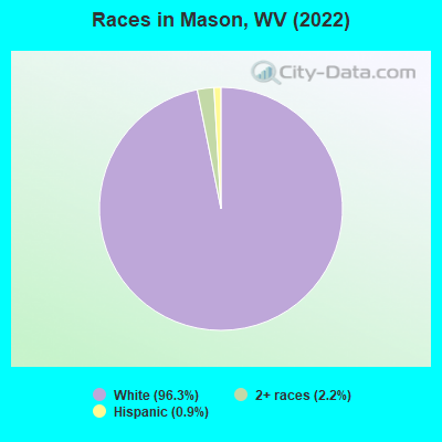
- 77996.3%White alone
- 182.2%Two or more races
- 70.9%Hispanic
Races in Mason detailed stats: ancestries, foreign born residents, place of birth
According to our research of West Virginia and other state lists, there were 3 registered sex offenders living in Mason, West Virginia as of July 03, 2024.
The ratio of all residents to sex offenders in Mason is 281 to 1.
The ratio of registered sex offenders to all residents in this city is near the state average.
Type |
2009 |
2010 |
2011 |
2012 |
2013 |
2014 |
2015 |
2016 |
2017 |
2018 |
2019 |
2020 |
2021 |
2022 |
|---|---|---|---|---|---|---|---|---|---|---|---|---|---|---|
| Murders (per 100,000) | 0 (0.0) | 0 (0.0) | 0 (0.0) | 0 (0.0) | 0 (0.0) | 0 (0.0) | 0 (0.0) | 0 (0.0) | 0 (0.0) | 0 (0.0) | 0 (0.0) | 0 (0.0) | 1 (109.3) | 0 (0.0) |
| Rapes (per 100,000) | 0 (0.0) | 0 (0.0) | 0 (0.0) | 0 (0.0) | 0 (0.0) | 0 (0.0) | 0 (0.0) | 1 (106.7) | 1 (107.9) | 0 (0.0) | 0 (0.0) | 0 (0.0) | 0 (0.0) | 0 (0.0) |
| Robberies (per 100,000) | 0 (0.0) | 0 (0.0) | 0 (0.0) | 1 (103.5) | 1 (104.6) | 0 (0.0) | 0 (0.0) | 0 (0.0) | 0 (0.0) | 0 (0.0) | 0 (0.0) | 0 (0.0) | 0 (0.0) | 0 (0.0) |
| Assaults (per 100,000) | 0 (0.0) | 0 (0.0) | 1 (103.2) | 1 (103.5) | 1 (104.6) | 1 (105.3) | 1 (106.3) | 0 (0.0) | 0 (0.0) | 0 (0.0) | 3 (321.2) | 1 (107.3) | 1 (109.3) | 0 (0.0) |
| Burglaries (per 100,000) | 0 (0.0) | 1 (103.3) | 2 (206.4) | 3 (310.6) | 1 (104.6) | 4 (421.1) | 6 (637.6) | 8 (853.8) | 3 (323.6) | 2 (212.5) | 0 (0.0) | 1 (107.3) | 0 (0.0) | 0 (0.0) |
| Thefts (per 100,000) | 3 (289.3) | 1 (103.3) | 5 (516.0) | 7 (724.6) | 6 (627.6) | 13 (1,368) | 46 (4,888) | 57 (6,083) | 56 (6,041) | 79 (8,395) | 32 (3,426) | 12 (1,288) | 0 (0.0) | 6 (709.2) |
| Auto thefts (per 100,000) | 0 (0.0) | 0 (0.0) | 0 (0.0) | 0 (0.0) | 0 (0.0) | 0 (0.0) | 0 (0.0) | 0 (0.0) | 0 (0.0) | 2 (212.5) | 0 (0.0) | 1 (107.3) | 0 (0.0) | 0 (0.0) |
| Arson (per 100,000) | 0 (0.0) | 0 (0.0) | 0 (0.0) | 0 (0.0) | 0 (0.0) | 0 (0.0) | 0 (0.0) | 0 (0.0) | 1 (107.9) | 1 (106.3) | 0 (0.0) | 0 (0.0) | 0 (0.0) | 0 (0.0) |
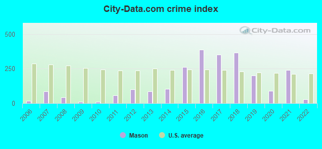
| City-Data.com crime index | 11.6 | 11.4 | 55.7 | 102.5 | 84.7 | 105.3 | 261.4 | 388.5 | 350.6 | 367.7 | 201.3 | 89.1 | 240.4 | 28.4 |
The City-Data.com crime index weighs serious crimes and violent crimes more heavily. Higher means more crime, U.S. average is 246.1. It adjusts for the number of visitors and daily workers commuting into cities.
Crime rate in Mason detailed stats: murders, rapes, robberies, assaults, burglaries, thefts, arson
Full-time law enforcement employees in 2021, including police officers: 6 (5 officers - 5 male; 0 female).
| Officers per 1,000 residents here: | 5.46 |
| West Virginia average: | 1.95 |
 Recent articles from our blog. Our writers, many of them Ph.D. graduates or candidates, create easy-to-read articles on a wide variety of topics.

 | Mason County news (12 replies) |
| Huntington continues to seek ways to improve (1016 replies) |
| Energy technology company to bring 500 jobs to Mason County (3 replies) |
| We need better politicians (65 replies) |
| Alternate universe where Charleston continued to grow (36 replies) |
| United Bank announces yet another acquisition (16 replies) |
Latest news from Mason, WV collected exclusively by city-data.com from local newspapers, TV, and radio stations
Ancestries: German (37.7%), Dutch (20.1%), English (13.2%), American (9.3%), Irish (5.4%), Scotch-Irish (3.9%).
Current Local Time: EST time zone
Elevation: 581 feet
Land area: 0.56 square miles.
Population density: 1,502 people per square mile (low).
4 residents are foreign born
| This town: | 0.5% |
| West Virginia: | 1.6% |
Median real estate property taxes paid for housing units with mortgages in 2022: $716 (0.8%)
Median real estate property taxes paid for housing units with no mortgage in 2022: $366 (0.4%)
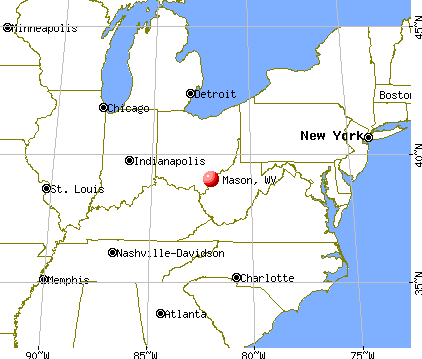
Nearest city with pop. 50,000+: Huntington, WV  (47.3 miles , pop. 51,475).
Nearest city with pop. 200,000+: Columbus, OH (84.4 miles , pop. 711,470).
Nearest city with pop. 1,000,000+: Chicago, IL (355.6 miles , pop. 2,896,016).
Nearest cities:
), ), ), ), ), )Latitude: 39.02 N, Longitude: 82.03 W
Area code: 304

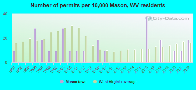
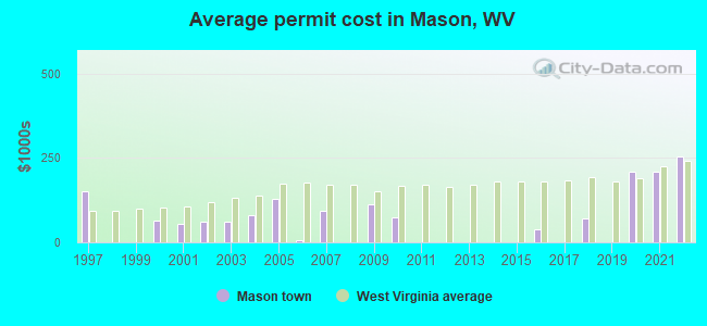
Single-family new house construction building permits:
- 2022: 2 buildings, average cost: $253,200
- 2021: 1 building, cost: $209,100
- 2020: 1 building, cost: $209,100
- 2018: 2 buildings, average cost: $70,100
- 2016: 4 buildings, average cost: $40,000
- 2010: 1 building, cost: $75,000
- 2009: 2 buildings, average cost: $112,500
- 2007: 1 building, cost: $92,000
- 2006: 1 building, cost: $8,000
- 2005: 1 building, cost: $130,000
- 2004: 3 buildings, average cost: $79,500
- 2003: 1 building, cost: $60,000
- 2002: 1 building, cost: $60,000
- 2001: 2 buildings, average cost: $53,500
- 2000: 3 buildings, average cost: $63,300
- 1997: 1 building, cost: $150,000
| Here: | 4.7% |
| West Virginia: | 4.0% |
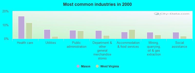
- Health care (16.4%)
- Utilities (6.7%)
- Public administration (6.2%)
- Department & other general merchandise stores (6.0%)
- Accommodation & food services (5.0%)
- Mining, quarrying, oil & gas extraction (4.7%)
- Social assistance (4.7%)
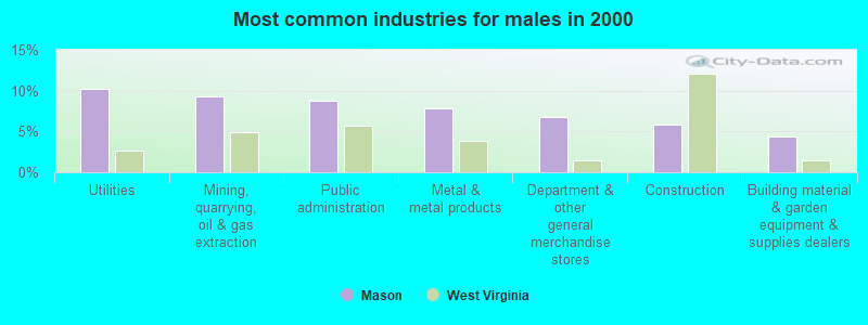
- Utilities (10.2%)
- Mining, quarrying, oil & gas extraction (9.3%)
- Public administration (8.8%)
- Metal & metal products (7.8%)
- Department & other general merchandise stores (6.8%)
- Construction (5.9%)
- Building material & garden equipment & supplies dealers (4.4%)
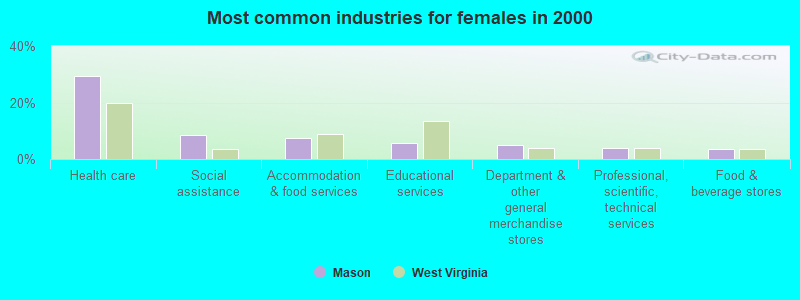
- Health care (29.3%)
- Social assistance (8.6%)
- Accommodation & food services (7.6%)
- Educational services (5.6%)
- Department & other general merchandise stores (5.1%)
- Professional, scientific, technical services (4.0%)
- Food & beverage stores (3.5%)
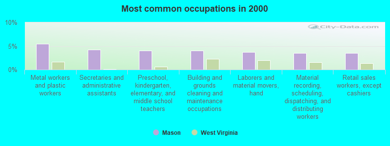
- Metal workers and plastic workers (5.5%)
- Secretaries and administrative assistants (4.2%)
- Preschool, kindergarten, elementary, and middle school teachers (4.0%)
- Building and grounds cleaning and maintenance occupations (4.0%)
- Laborers and material movers, hand (3.7%)
- Material recording, scheduling, dispatching, and distributing workers (3.5%)
- Retail sales workers, except cashiers (3.5%)
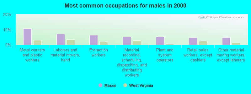
- Metal workers and plastic workers (10.7%)
- Laborers and material movers, hand (7.3%)
- Extraction workers (6.3%)
- Material recording, scheduling, dispatching, and distributing workers (5.4%)
- Plant and system operators (5.4%)
- Retail sales workers, except cashiers (4.9%)
- Other material moving workers, except laborers (4.9%)
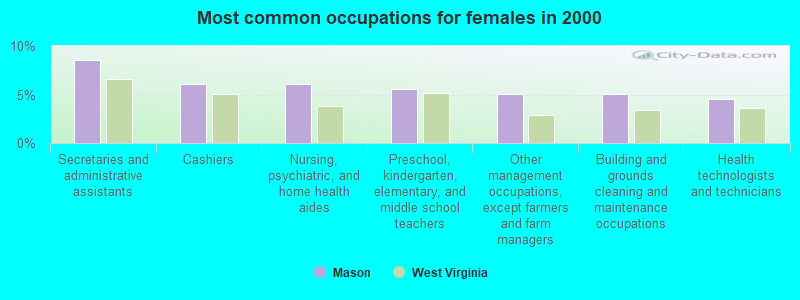
- Secretaries and administrative assistants (8.6%)
- Cashiers (6.1%)
- Nursing, psychiatric, and home health aides (6.1%)
- Preschool, kindergarten, elementary, and middle school teachers (5.6%)
- Other management occupations, except farmers and farm managers (5.1%)
- Building and grounds cleaning and maintenance occupations (5.1%)
- Health technologists and technicians (4.5%)
Average climate in Mason, West Virginia
Based on data reported by over 4,000 weather stations


|
|


(lower is better)
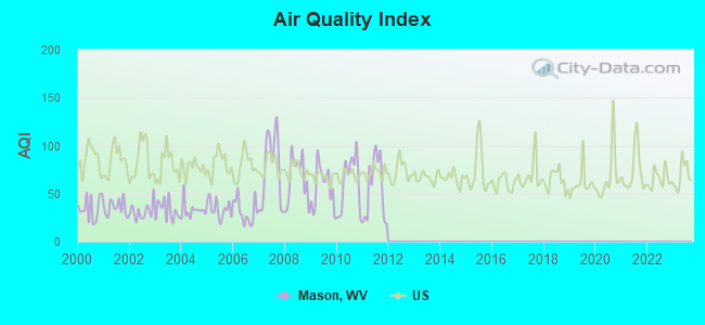
Air Quality Index (AQI) level in 2011 was 55.0. This is better than average.
| City: | 55.0 |
| U.S.: | 72.6 |
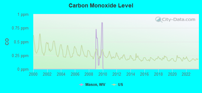
Carbon Monoxide (CO) [ppm] level in 2009 was 0.442. This is significantly worse than average. Closest monitor was 20.5 miles away from the city center.
| City: | 0.442 |
| U.S.: | 0.251 |
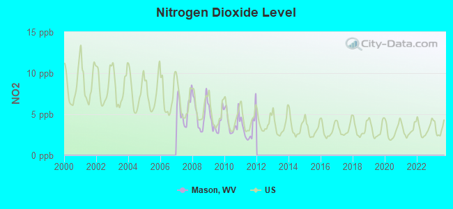
Nitrogen Dioxide (NO2) [ppb] level in 2011 was 3.36. This is significantly better than average. Closest monitor was 7.2 miles away from the city center.
| City: | 3.36 |
| U.S.: | 5.11 |
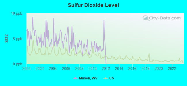
Sulfur Dioxide (SO2) [ppb] level in 2011 was 3.66. This is significantly worse than average. Closest monitor was 1.5 miles away from the city center.
| City: | 3.66 |
| U.S.: | 1.51 |
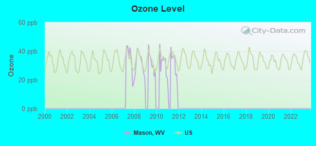
Ozone [ppb] level in 2011 was 28.5. This is about average. Closest monitor was 20.5 miles away from the city center.
| City: | 28.5 |
| U.S.: | 33.3 |
Tornado activity:
Mason-area historical tornado activity is above West Virginia state average. It is 53% smaller than the overall U.S. average.
On 4/23/1968, a category F5 (max. wind speeds 261-318 mph) tornado 16.5 miles away from the Mason town center killed 7 people and injured 93 people and caused between $500,000 and $5,000,000 in damages.
On 4/23/1968, a category F4 (max. wind speeds 207-260 mph) tornado 48.8 miles away from the town center killed 6 people and injured 364 people and caused between $5,000,000 and $50,000,000 in damages.
Earthquake activity:
Mason-area historical earthquake activity is significantly above West Virginia state average. It is 8% smaller than the overall U.S. average.On 8/23/2011 at 17:51:04, a magnitude 5.8 (5.8 MW, Depth: 3.7 mi, Class: Moderate, Intensity: VI - VII) earthquake occurred 234.6 miles away from Mason center
On 7/27/1980 at 18:52:21, a magnitude 5.2 (5.1 MB, 4.7 MS, 5.0 UK, 5.2 UK) earthquake occurred 117.7 miles away from Mason center
On 9/25/1998 at 19:52:52, a magnitude 5.2 (4.8 MB, 4.3 MS, 5.2 LG, 4.5 MW, Depth: 3.1 mi) earthquake occurred 191.5 miles away from Mason center
On 8/9/2020 at 12:07:37, a magnitude 5.1 (5.1 MW, Depth: 4.7 mi) earthquake occurred 183.3 miles away from Mason center
On 1/31/1986 at 16:46:43, a magnitude 5.0 (5.0 MB) earthquake occurred 184.4 miles away from the city center
On 9/7/1988 at 02:28:09, a magnitude 4.6 (4.5 MB, 4.6 LG, Class: Light, Intensity: IV - V) earthquake occurred 116.8 miles away from the city center
Magnitude types: regional Lg-wave magnitude (LG), body-wave magnitude (MB), surface-wave magnitude (MS), moment magnitude (MW)
Natural disasters:
The number of natural disasters in Mason County (18) is near the US average (15).Major Disasters (Presidential) Declared: 13
Emergencies Declared: 4
Causes of natural disasters: Floods: 9, Storms: 9, Landslides: 4, Winter Storms: 3, Hurricanes: 2, Blizzard: 1, Mudslide: 1, Snowfall: 1, Wind: 1, Other: 1 (Note: some incidents may be assigned to more than one category).

Hospitals and medical centers near Mason:
- VETERANS MEM SKILLED NRSG FAC (Nursing Home, about 2 miles away; POMEROY, OH)
- OVERBROOK CENTER (Nursing Home, about 3 miles away; MIDDLEPORT, OH)
- ROCKSPRINGS REHABILITATION CENTER (Nursing Home, about 6 miles away; POMEROY, OH)
- POINT PLEASANT DIALYSIS (Dialysis Facility, about 11 miles away; POINT PLEASANT, WV)
- PLEASANT VALLEY HOME HEALTH (Home Health Center, about 14 miles away; POINT PLEASANT, WV)
- HOME HEALTH CARE OF SOUTHEAST OHIO, INC (Home Health Center, about 14 miles away; GUYSVILLE, OH)
- BCS/PORTER ROAD HOME (Hospital, about 15 miles away; BIDWELL, OH)
located in Mason:
Colleges/universities with over 2000 students nearest to Mason:
- Ohio University-Main Campus (about 22 miles; Athens, OH; Full-time enrollment: 26,181)
- Hocking College (about 32 miles; Nelsonville, OH; FT enrollment: 4,146)
- West Virginia University at Parkersburg (about 32 miles; Parkersburg, WV; FT enrollment: 2,619)
- West Virginia State University (about 47 miles; Institute, WV; FT enrollment: 2,133)
- Marshall University (about 47 miles; Huntington, WV; FT enrollment: 11,450)
- Ashland Community and Technical College (about 51 miles; Ashland, KY; FT enrollment: 2,482)
- Shawnee State University (about 56 miles; Portsmouth, OH; FT enrollment: 4,160)
Public high school in Mason:
- WAHAMA HIGH SCHOOL (Students: 435, Location: #1 WHITE FALCON DRIVE, Grades: 7-12)
Points of interest:
Notable locations in Mason: Mason County Emergency Ambulance Service Authority 500 (A), Mason Volunteer Fire Department (B). Display/hide their locations on the map
Cemetery: Saint Josephs Cemetery (1). Display/hide its location on the map
Tourist attraction: State Line Big Time Coffee Shop (Amusement & Theme Parks; 393 South 2nd Street).
Drinking water stations with addresses in Mason and their reported violations in the past:
MASON WATER DEPT (Population served: 2,038, Groundwater):Past health violations:Past monitoring violations:
- Treatment Technique (SWTR and GWR) - In DEC-2009, Contaminant: GROUNDWATER RULE. Follow-up actions: St Compliance achieved (JAN-15-2010), St Public Notif requested (APR-16-2010), St Formal NOV issued (APR-16-2010), St Public Notif received (JUL-12-2010)
- Lead Consumer Notice - In DEC-30-2013, Contaminant: Lead and Copper Rule. Follow-up actions: St Formal NOV issued (FEB-14-2014), St Public Notif requested (FEB-14-2014)
- Follow-up Or Routine LCR Tap M/R - In OCT-01-2013, Contaminant: Lead and Copper Rule. Follow-up actions: St Formal NOV issued (NOV-14-2013), St Public Notif requested (NOV-14-2013)
- Monitoring and Reporting (DBP) - Between JAN-2009 and DEC-2009, Contaminant: TTHM. Follow-up actions: St Formal NOV issued (JAN-30-2010), St Compliance achieved (FEB-17-2010)
- Monitoring and Reporting (DBP) - Between JAN-2009 and DEC-2009, Contaminant: Total Haloacetic Acids (HAA5). Follow-up actions: St Formal NOV issued (JAN-30-2010), St Compliance achieved (FEB-17-2010)
- One minor monitoring violation
- 57 regular monitoring violations
| This town: | 2.3 people |
| West Virginia: | 2.4 people |
| This town: | 63.6% |
| Whole state: | 65.8% |
| This town: | 7.5% |
| Whole state: | 6.6% |
Likely homosexual households (counted as self-reported same-sex unmarried-partner households)
- Lesbian couples: 0.5% of all households
- Gay men: 0.0% of all households
Banks with branches in Mason (2011 data):
- City National Bank of West Virginia: Mason Branch at Second And Brown Streets, branch established on 1983/07/06. Info updated 2008/01/10: Bank assets: $2,753.2 mil, Deposits: $2,223.1 mil, headquarters in Charleston, WV, positive income, Commercial Lending Specialization, 68 total offices, Holding Company: City Holding Company
- The Farmers Bank and Savings Company: Mason Branch at 424 Second Street, branch established on 2003/06/30. Info updated 2006/11/03: Bank assets: $255.0 mil, Deposits: $224.7 mil, headquarters in Pomeroy, OH, positive income, 5 total offices, Holding Company: Farmers Bancshares, Inc.
For population 15 years and over in Mason:
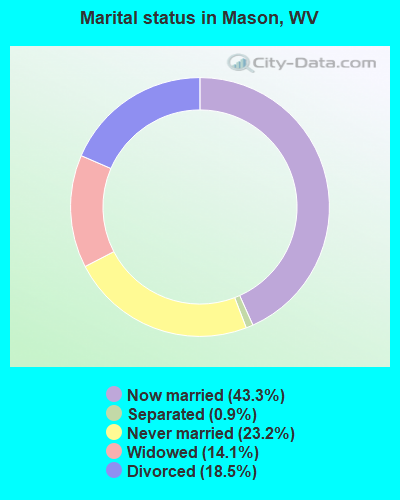
- Never married: 23.2%
- Now married: 43.3%
- Separated: 0.9%
- Widowed: 14.1%
- Divorced: 18.5%
For population 25 years and over in Mason:
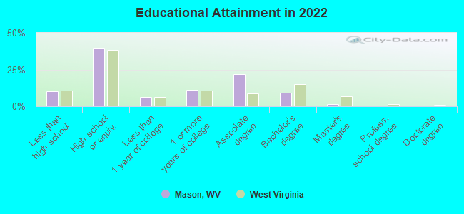
- High school or higher: 88.3%
- Bachelor's degree or higher: 9.7%
- Graduate or professional degree: 1.5%
- Unemployed: 6.5%
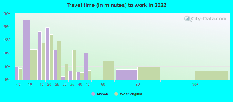
- Mean travel time to work (commute): 28.3 minutes
| Here: | 8.7 |
| West Virginia average: | 11.1 |
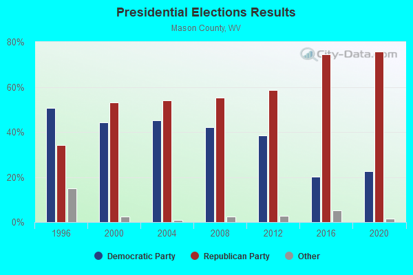
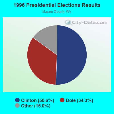
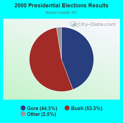
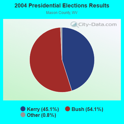
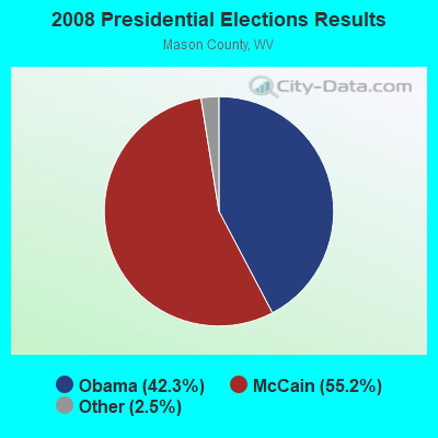
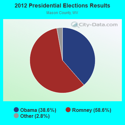
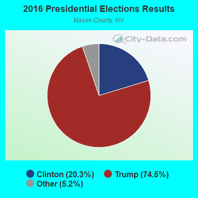
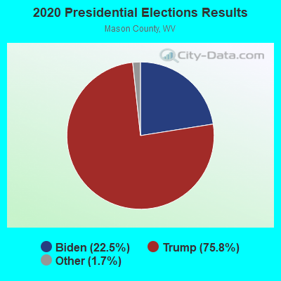
Graphs represent county-level data. Detailed 2008 Election Results
Religion statistics for Mason, WV (based on Mason County data)
| Religion | Adherents | Congregations |
|---|---|---|
| Mainline Protestant | 4,296 | 33 |
| Evangelical Protestant | 1,849 | 21 |
| Catholic | 171 | 1 |
| Other | - | 1 |
| None | 21,008 | - |
Food Environment Statistics:
| Mason County: | 1.57 / 10,000 pop. |
| West Virginia: | 2.41 / 10,000 pop. |
| Mason County: | 0.39 / 10,000 pop. |
| West Virginia: | 0.28 / 10,000 pop. |
| Mason County: | 0.78 / 10,000 pop. |
| West Virginia: | 1.09 / 10,000 pop. |
| Mason County: | 4.31 / 10,000 pop. |
| State: | 5.38 / 10,000 pop. |
| Mason County: | 4.70 / 10,000 pop. |
| West Virginia: | 6.22 / 10,000 pop. |
| Mason County: | 14.1% |
| West Virginia: | 12.2% |
| Here: | 31.9% |
| West Virginia: | 31.1% |
| Here: | 14.5% |
| State: | 13.1% |
Health and Nutrition:
| This city: | 45.2% |
| West Virginia: | 51.8% |
| This city: | 43.1% |
| West Virginia: | 49.7% |
| Mason: | 28.8 |
| West Virginia: | 28.6 |
| Mason: | 24.1% |
| State: | 20.4% |
| Mason: | 11.9% |
| West Virginia: | 9.7% |
| This city: | 6.8 |
| West Virginia: | 6.9 |
| This city: | 31.3% |
| West Virginia: | 34.8% |
| Here: | 50.4% |
| State: | 58.4% |
| Mason: | 84.3% |
| State: | 78.6% |
More about Health and Nutrition of Mason, WV Residents
| Local government employment and payroll (March 2022) | |||||
| Function | Full-time employees | Monthly full-time payroll | Average yearly full-time wage | Part-time employees | Monthly part-time payroll |
|---|---|---|---|---|---|
| Police Protection - Officers | 5 | $14,853 | $35,647 | 0 | $0 |
| Water Supply | 3 | $9,548 | $38,192 | 0 | $0 |
| Other and Unallocable | 2 | $4,203 | $25,218 | 1 | $957 |
| Other Government Administration | 0 | $0 | 2 | $1,661 | |
| Judicial and Legal | 0 | $0 | 1 | $1,453 | |
| Financial Administration | 0 | $0 | 1 | $200 | |
| Totals for Government | 10 | $28,604 | $34,325 | 5 | $4,270 |
Mason government finances - Expenditure in 2017 (per resident):
- Construction - Parks and Recreation: $25,000 ($29.73)
- Current Operations - Police Protection: $232,000 ($275.86)
Water Utilities: $200,000 ($237.81)
Sewerage: $183,000 ($217.60)
General Public Buildings: $118,000 ($140.31)
Parks and Recreation: $27,000 ($32.10)
Central Staff Services: $18,000 ($21.40)
General - Other: $10,000 ($11.89)
Regular Highways: $9,000 ($10.70)
Libraries: $6,000 ($7.13)
Financial Administration: $3,000 ($3.57)
Judicial and Legal Services: $2,000 ($2.38)
Health - Other: $1,000 ($1.19)
- Total Salaries and Wages: $183,000 ($217.60)
- Water Utilities - Interest on Debt: $117,000 ($139.12)
Mason government finances - Revenue in 2017 (per resident):
- Charges - Sewerage: $250,000 ($297.27)
- Miscellaneous - General Revenue - Other: $59,000 ($70.15)
Fines and Forfeits: $28,000 ($33.29)
Rents: $3,000 ($3.57)
Donations From Private Sources: $1,000 ($1.19)
- Revenue - Water Utilities: $382,000 ($454.22)
- State Intergovernmental - Public Welfare: $8,000 ($9.51)
- Tax - Occupation and Business License - Other: $196,000 ($233.06)
Property: $75,000 ($89.18)
Public Utilities Sales: $44,000 ($52.32)
Other Selective Sales: $18,000 ($21.40)
Alcoholic Beverage Sales: $5,000 ($5.95)
Other License: $3,000 ($3.57)
Severance: $1,000 ($1.19)
Mason government finances - Debt in 2017 (per resident):
- Long Term Debt - Outstanding Unspecified Public Purpose: $4,445,000 ($5285.37)
Beginning Outstanding - Unspecified Public Purpose: $2,920,000 ($3472.06)
Issue, Unspecified Public Purpose: $1,658,000 ($1971.46)
Retired Unspecified Public Purpose: $133,000 ($158.15)
Mason government finances - Cash and Securities in 2017 (per resident):
- Bond Funds - Cash and Securities: $1,500,000 ($1783.59)
- Other Funds - Cash and Securities: $553,000 ($657.55)
Businesses in Mason, WV
- Walmart: 1
Strongest AM radio stations in Mason:
- WMPO (1390 AM; 5 kW; MIDDLEPORT-POMEROY, OH; Owner: POSITIVE RADIO GROUP, INC. OF OHIO)
- WBGS (1030 AM; daytime; 10 kW; POINT PLEASANT, WV; Owner: BIG RIVER RADIO, INC.)
- WTVN (610 AM; 50 kW; COLUMBUS, OH; Owner: CITICASTERS LICENSES, L.P.)
- WADC (1050 AM; 5 kW; PARKERSBURG, WV; Owner: BURBACH OF DE, LLC)
- WBRJ (910 AM; 5 kW; MARIETTA, OH; Owner: CLEAR CHANNEL BROADCASTING LICENSES, INC.)
- WWVA (1170 AM; 53 kW; WHEELING, WV; Owner: CAPSTAR TX LIMITED PARTNERSHIP)
- WCAW (680 AM; 10 kW; CHARLESTON, WV; Owner: WEST VIRGINIA RADIO CORPORATION OF CHARLESTON)
- WLW (700 AM; 50 kW; CINCINNATI, OH; Owner: JACOR BROADCASTING CORPORATION)
- WRFD (880 AM; daytime; 23 kW; COLUMBUS-WORTHINGTON, OH; Owner: SALEM MEDIA OF OHIO, INC.)
- WCHS (580 AM; 5 kW; CHARLESTON, WV; Owner: WEST VIRGINIA RADIO CORPORATION OF CHARLESTON)
- WMOV (1360 AM; daytime; 1 kW; RAVENSWOOD, WV; Owner: HAROLD F. PARSHALL)
- WJEH (990 AM; 1 kW; GALLIPOLIS, OH; Owner: LEGEND COMMUNICATIONS OF OHIO, LLC)
- WVHU (800 AM; 5 kW; HUNTINGTON, WV; Owner: CAPSTAR TX LIMITED PARTNERSHIP)
Strongest FM radio stations in Mason:
- WYVK (92.1 FM; MIDDLEPORT, OH; Owner: POSITIVE RADIO GROUP, INC. OF OHIO)
- WRZZ (106.1 FM; ELIZABETH, WV; Owner: CLEAR CHANNEL BROADCASTING LICENSES, INC.)
- WKLC-FM (105.1 FM; ST. ALBANS, WV; Owner: WKLC, INC.)
- WLWF (93.1 FM; RAVENSWOOD, WV; Owner: LEGEND COMMUNICATIONS OF WEST VIRGINIA, LLC)
- WBYG (99.5 FM; POINT PLEASANT, WV; Owner: BIG RIVER RADIO, INC.)
- WRYV (101.5 FM; GALLIPOLIS, OH; Owner: LEGEND COMMUNICATIONS OF OHIO, LLC)
- WJKW (95.9 FM; ATHENS, OH; Owner: CHRISTIAN FAITH BROADCAST, INC.)
- WPCN (88.1 FM; POINT PLEASANT, WV; Owner: POSITIVE ALTERNATIVE RADIO, INC.)
- WVWV (89.9 FM; HUNTINGTON, WV; Owner: WEST VIRGINIA EDUCATIONAL BROADCASTING AUTHORITY)
- WAMX (106.3 FM; MILTON, WV; Owner: CAPSTAR TX LIMITED PARTNERSHIP)
- WOUB-FM (91.3 FM; ATHENS, OH; Owner: OHIO UNIVERSITY)
- WGGE (99.1 FM; PARKERSBURG, WV; Owner: BURBACH OF DE, LLC)
- W211BT (90.1 FM; ATHENS, OH; Owner: THE CEDARVILLE UNIVERSITY)
- WVRP (90.7 FM; RIPLEY, WV; Owner: LOWER OHIO VALLEY EDUCATIONAL CORP.)
- WRVB (102.1 FM; MARIETTA, OH; Owner: CLEAR CHANNEL BROADCASTING LICENSES, INC.)
- WXTQ (105.5 FM; ATHENS, OH; Owner: WATH, INC.)
TV broadcast stations around Mason:
- WJOS-LP (Channel 58; POMEROY, OH; Owner: WILLIAM A. BARNHARDT)
- WOUB-TV (Channel 20; ATHENS, OH; Owner: OHIO UNIVERSITY)
- WVAH-TV (Channel 11; CHARLESTON, WV; Owner: WVAH LICENSEE, LLC)
- WPBY-TV (Channel 33; HUNTINGTON, WV; Owner: WEST VIRGINIA EDUCATIONAL BROADCASTING AUTHORITY)
- WSAZ-TV (Channel 3; HUNTINGTON, WV; Owner: EMMIS TELEVISION LICENSE CORPORATION)
- WCHS-TV (Channel 8; CHARLESTON, WV; Owner: WCHS LICENSEE, LLC)
- WOWK-TV (Channel 13; HUNTINGTON, WV; Owner: WEST VIRGINIA MEDIA HOLDINGS, LLC)
- WLPX-TV (Channel 29; CHARLESTON, WV; Owner: PAXSON CHARLESTON LICENSE, INC.)
Mason fatal accident list:
May 25, 2005 09:39 PM, Us-33, Lat: 39.020480, Lon: -82.031000, Vehicles: 2, Persons: 4, Fatalities: 1
Jul 3, 2000 03:59 PM, Us-33, Vehicles: 2, Persons: 3, Fatalities: 1
Dec 7, 1985 01:36 AM, 33, Vehicles: 1, Persons: 1, Fatalities: 1, Drunk persons involved: 1
- National Bridge Inventory (NBI) Statistics
- 4Number of bridges
- 207ft / 63.3mTotal length
- $1,058,000Total costs
- 18,187Total average daily traffic
- 1,335Total average daily truck traffic
FCC Registered Cell Phone Towers:
1 (See the full list of FCC Registered Cell Phone Towers in Mason)FCC Registered Antenna Towers:
11 (See the full list of FCC Registered Antenna Towers)FCC Registered Broadcast Land Mobile Towers:
2- City Bldg (Lat: 39.002861 Lon: -81.993194), Call Sign: KNES272, Licensee ID: L00094431,
Assigned Frequencies: 39.8800 MHz, 39.9800 MHz, Grant Date: 12/23/1997, Expiration Date: 02/12/2003, Cancellation Date: 11/14/2002, Registrant: Mason, Town Of, Mason, WV 25260
- 1 White Falcon Dr (Lat: 39.009944 Lon: -82.036528), Type: Bant, Structure height: 5 m, Overall height: 8 m, Call Sign: WQOB876,
Assigned Frequencies: 462.750 MHz, Grant Date: 08/05/2011, Expiration Date: 08/05/2021, Cancellation Date: 10/09/2021, Certifier: Greg Martin, Registrant: Visiplex, Inc., 100 N Fairway Drive, Suite 120, Vernon Hills, IL 60061, Phone: (847) 918-0250, Fax: (847) 918-0259, Email:
FCC Registered Paging Towers:
1- 3000' South Of Us 33, 1 Mile East Of (Lat: 39.016722 Lon: -82.014583), Call Sign: KNKL577,
Assigned Frequencies: 454.525 MHz, Grant Date: 10/27/2009, Expiration Date: 11/04/2019, Cancellation Date: 12/03/2010, Certifier: Glenn S Rabin, Registrant: Verizon Wireless, 1120 Sanctuary Pkwy, #150 Gasa5reg, Alpharetta, GA 30009-7630, Phone: (770) 797-1070, Fax: (770) 797-1036, Email:
FCC Registered Amateur Radio Licenses:
12 (See the full list of FCC Registered Amateur Radio Licenses in Mason)2003 - 2018 National Fire Incident Reporting System (NFIRS) incidents
- Fire incident types reported to NFIRS in Mason, WV
- 9753.3%Structure Fires
- 5429.7%Outside Fires
- 2011.0%Mobile Property/Vehicle Fires
- 116.0%Other
 Based on the data from the years 2003 - 2018 the average number of fires per year is 11. The highest number of fire incidents - 27 took place in 2007, and the least - 2 in 2003. The data has a rising trend.
 When looking into fire subcategories, the most incidents belonged to: Structure Fires (53.3%), and Outside Fires (29.7%).
| Most common first names in Mason, WV among deceased individuals | ||
| Name | Count | Lived (average) |
|---|---|---|
| John | 20 | 77.7 years |
| William | 20 | 69.8 years |
| James | 13 | 67.3 years |
| George | 10 | 69.1 years |
| Mary | 9 | 73.4 years |
| Harold | 9 | 72.0 years |
| Helen | 8 | 81.6 years |
| Charles | 8 | 64.0 years |
| Clara | 7 | 86.5 years |
| Robert | 7 | 73.9 years |
| Most common last names in Mason, WV among deceased individuals | ||
| Last name | Count | Lived (average) |
|---|---|---|
| Johnson | 31 | 75.0 years |
| Roush | 29 | 72.3 years |
| Smith | 13 | 72.8 years |
| Stewart | 11 | 75.1 years |
| Riley | 7 | 80.0 years |
| Young | 6 | 74.0 years |
| Ingels | 6 | 73.7 years |
| Lewis | 6 | 67.7 years |
| Mcdaniel | 6 | 75.8 years |
| Casto | 6 | 69.7 years |
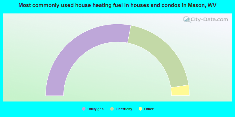
- 56.2%Utility gas
- 39.4%Electricity
- 3.0%Fuel oil, kerosene, etc.
- 1.3%No fuel used
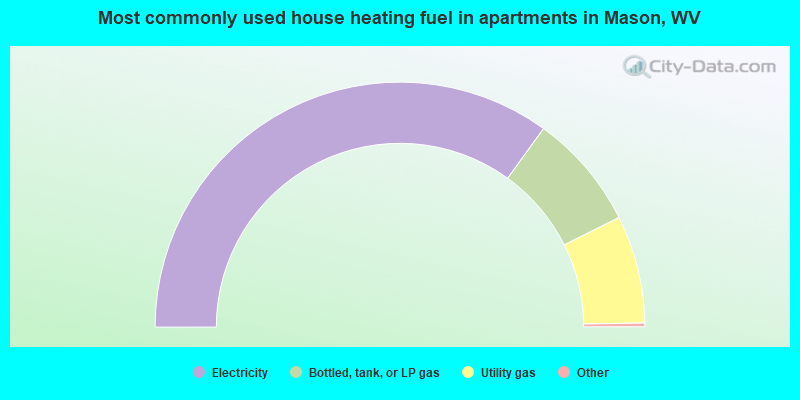
- 70.3%Electricity
- 15.4%Bottled, tank, or LP gas
- 14.3%Utility gas
Mason compared to West Virginia state average:
- Median house value below state average.
- Unemployed percentage below state average.
- Black race population percentage significantly below state average.
- Hispanic race population percentage significantly below state average.
- Foreign-born population percentage significantly below state average.
- Length of stay since moving in significantly above state average.
- Percentage of population with a bachelor's degree or higher below state average.