Martinsdale-Ringling, Montana
Submit your own pictures of this place and show them to the world
- OSM Map
- Google Map
- MSN Map
| Males: 206 | |
| Females: 182 |
| Median resident age: | 45.1 years |
| Montana median age: | 37.5 years |
Zip code: 59053
| Martinsdale-Ringling: | $52,402 |
| MT: | $67,631 |
Estimated per capita income in 2022: $48,016 (it was $18,985 in 2000)
Martinsdale-Ringling CCD income, earnings, and wages data
Estimated median house or condo value in 2022: $250,031 (it was $69,300 in 2000)
| Martinsdale-Ringling: | $250,031 |
| MT: | $366,400 |
Mean prices in 2022: all housing units: $304,247; detached houses: $345,662; townhouses or other attached units: $494,683; mobile homes: $57,487
Martinsdale-Ringling, MT residents, houses, and apartments details
Detailed information about poverty and poor residents in Martinsdale-Ringling, MT
Compare current foreclosures near your location:
| Photo | Address | Area | Beds / Baths | Price | Details |
|---|---|---|---|---|---|

|
#1
N Rhodes St
Pretty Prairie, KS 67570
|
1,725 sq. feet
|
2 baths 4 beds |
show details | |

|
#2
W 21st St N
Cheney, KS 67025
|
3,190 sq. feet
|
3 baths 5 beds |
show details | |

|
#3
NE Waterloo Ave
Murdock, KS 67111
|
1,220 sq. feet
|
1 baths 3 beds |
show details | |

|
#4
E Arlington Rd
Haven, KS 67543
|
960 sq. feet
|
1 baths 2 beds |
show details | |

|
#5
E Winterset St
Goddard, KS 67052
|
816 sq. feet
|
1 baths 2 beds |
show details | |

|
#6
W 39th St S
Goddard, KS 67052
|
4,221 sq. feet
|
3 baths 3 beds |
show details | |

|
#7
E 4th Ave Apt 1
Cheney, KS 67025
|
- sq. feet
|
- baths - beds |
show details | |

|
#8
SE Viney Ave
Murdock, KS 67111
|
- sq. feet
|
- baths - beds |
show details | |

|
#9
W Main St
Mount Hope, KS 67108
|
- sq. feet
|
- baths - beds |
show details | |

|
#10
N 189th Cir W
Colwich, KS 67030
|
- sq. feet
|
- baths - beds |
show details |
| Photo | Address | Area | Beds / Baths | Price | Details |
|---|---|---|---|---|---|

|
#11
N Main St
Goddard, KS 67052
|
- sq. feet
|
- baths - beds |
show details | |

|
#12
Martens Ct
Goddard, KS 67052
|
- sq. feet
|
- baths - beds |
show details | |

|
#13
W Maple St Lot D
Goddard, KS 67052
|
- sq. feet
|
- baths - beds |
show details | |

|
#14
S 339th St W
Cheney, KS 67025
|
- sq. feet
|
- baths - beds |
show details | |

|
#15
E Casey Dr
Goddard, KS 67052
|
- sq. feet
|
- baths - beds |
show details | |

|
Check over 1 million property listings on Foreclosure.com!
|
browse all offers | |||

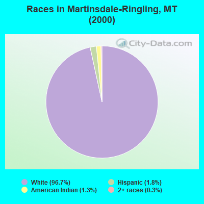
- 37896.7%White alone
- 71.8%Hispanic
- 51.3%American Indian alone
- 10.3%Two or more races
Races in Martinsdale-Ringling detailed stats: ancestries, foreign born residents, place of birth
 Recent articles from our blog. Our writers, many of them Ph.D. graduates or candidates, create easy-to-read articles on a wide variety of topics.
Current Local Time: MST time zone
Land area: 1052.8 square miles.
Population density: 0.4 people per square mile (very low).
| Martinsdale-Ringling CCD: | 0.5% ($375) |
| Montana: | 1.3% ($1,212) |
Nearest city with pop. 50,000+: Great Falls, MT  (81.0 miles , pop. 56,690).
Nearest city with pop. 200,000+: West Adams, CO (534.6 miles , pop. 259,628).
Nearest city with pop. 1,000,000+: Phoenix, AZ (894.8 miles , pop. 1,321,045).
Nearest cities:
), Latitude: 46.42 N, Longitude: 110.64 W
Area code commonly used in this area: 406
| Here: | 3.3% |
| Montana: | 3.8% |

- Agriculture, forestry, fishing & hunting (45.9%)
- Accommodation & food services (11.5%)
- Building material & garden equipment & supplies dealers (6.6%)
- Construction (6.0%)
- Public administration (3.8%)
- Professional, scientific, technical services (3.8%)
- Educational services (3.3%)
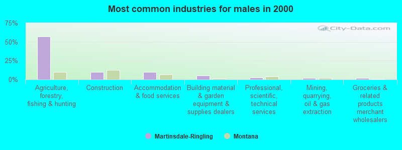
- Agriculture, forestry, fishing & hunting (57.3%)
- Construction (10.0%)
- Accommodation & food services (10.0%)
- Building material & garden equipment & supplies dealers (5.5%)
- Professional, scientific, technical services (2.7%)
- Mining, quarrying, oil & gas extraction (1.8%)
- Groceries & related products merchant wholesalers (1.8%)
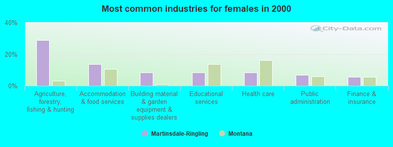
- Agriculture, forestry, fishing & hunting (28.8%)
- Accommodation & food services (13.7%)
- Building material & garden equipment & supplies dealers (8.2%)
- Educational services (8.2%)
- Health care (8.2%)
- Public administration (6.8%)
- Finance & insurance (5.5%)
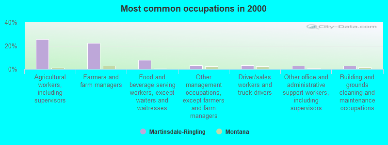
- Agricultural workers, including supervisors (25.7%)
- Farmers and farm managers (22.4%)
- Food and beverage serving workers, except waiters and waitresses (7.7%)
- Other management occupations, except farmers and farm managers (3.3%)
- Driver/sales workers and truck drivers (3.3%)
- Other office and administrative support workers, including supervisors (2.7%)
- Building and grounds cleaning and maintenance occupations (2.7%)

- Agricultural workers, including supervisors (32.7%)
- Farmers and farm managers (26.4%)
- Food and beverage serving workers, except waiters and waitresses (7.3%)
- Other management occupations, except farmers and farm managers (5.5%)
- Driver/sales workers and truck drivers (5.5%)
- Life, physical, and social science technicians (2.7%)
- Other sales and related occupations, including supervisors (2.7%)
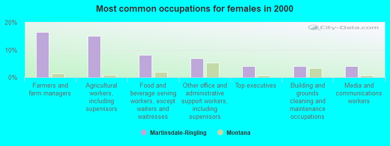
- Farmers and farm managers (16.4%)
- Agricultural workers, including supervisors (15.1%)
- Food and beverage serving workers, except waiters and waitresses (8.2%)
- Other office and administrative support workers, including supervisors (6.8%)
- Top executives (4.1%)
- Building and grounds cleaning and maintenance occupations (4.1%)
- Media and communications workers (4.1%)
Average climate in Martinsdale-Ringling, Montana
Based on data reported by over 4,000 weather stations


Earthquake activity:
Martinsdale-Ringling-area historical earthquake activity is significantly above Montana state average. It is 827% greater than the overall U.S. average.On 8/18/1959 at 06:37:13, a magnitude 7.7 (7.7 UK, Class: Major, Intensity: VIII - XII) earthquake occurred 128.1 miles away from Martinsdale-Ringling center, causing $26,000,000 total damage
On 10/28/1983 at 14:06:06, a magnitude 7.3 (6.2 MB, 7.3 MS, 7.0 MW) earthquake occurred 223.4 miles away from Martinsdale-Ringling center, causing 2 deaths (2 shaking deaths) and 3 injuries, causing $15,000,000 total damage
On 6/30/1975 at 18:54:13, a magnitude 6.1 (5.6 MB, 5.9 MS, 6.1 UK, 6.1 ML, Class: Strong, Intensity: VII - IX) earthquake occurred 120.8 miles away from Martinsdale-Ringling center
On 7/6/2017 at 06:30:17, a magnitude 5.8 (5.8 MW, Depth: 7.6 mi, Class: Moderate, Intensity: VI - VII) earthquake occurred 97.3 miles away from Martinsdale-Ringling center
On 3/31/2020 at 23:52:30, a magnitude 6.5 (6.5 MW, Depth: 7.5 mi) earthquake occurred 255.8 miles away from Martinsdale-Ringling center
On 7/26/2005 at 04:08:37, a magnitude 5.7 (5.7 MB, 5.2 MS, 5.6 MW) earthquake occurred 116.8 miles away from the city center
Magnitude types: body-wave magnitude (MB), local magnitude (ML), surface-wave magnitude (MS), moment magnitude (MW)
Natural disasters:
The number of natural disasters in Meagher County (8) is smaller than the US average (15).Major Disasters (Presidential) Declared: 5
Emergencies Declared: 1
Causes of natural disasters: Floods: 4, Storms: 4, Fires: 2, Snows: 2, Hurricane: 1, Other: 1 (Note: some incidents may be assigned to more than one category).
Colleges/universities with over 2000 students nearest to Martinsdale-Ringling:
- Montana State University (about 56 miles; Bozeman, MT; Full-time enrollment: 12,942)
- Montana State University-Billings (about 111 miles; Billings, MT; FT enrollment: 4,319)
- The University of Montana (about 162 miles; Missoula, MT; FT enrollment: 13,602)
- Brigham Young University-Idaho (about 189 miles; Rexburg, ID; FT enrollment: 30,522)
- Sheridan College (about 213 miles; Sheridan, WY; FT enrollment: 2,070)
- Idaho State University (about 262 miles; Pocatello, ID; FT enrollment: 10,350)
- North Idaho College (about 303 miles; Coeur d'Alene, ID; FT enrollment: 4,684)
Points of interest:
Notable locations in Martinsdale-Ringling: Adkison Ranch (A), Arthun Ranch (B), Bair Reservoir Sportsmans Access (C), Blackhawk Cabin (D), Brekke Ranch (E), Brewer Ranch (F), McKee Homestead (G), Campbell Ranch (H), Culver Ranch (I), Solbergs Pine Valley Cabins (J), Richardson Campground (K), Robertson Ranch (L), Rostad Ranch (M), Seventyone Ranch (N), Green Ranch (O), Hamen Ranch (P), Higgins Homestead (Q), Higgins Ranch (R), J Stewart Ranch (S), Spring Creek Campground (T). Display/hide their locations on the map
Churches in Martinsdale-Ringling include: Trinity Lutheran Church (A), Lutheran Church (B), Saint Johns Catholic Church (C). Display/hide their locations on the map
Cemeteries: Castle Cemetery (1), Lennup Cemetery (2), Lebo Cemetery (3). Display/hide their locations on the map
Lakes and reservoirs: Forest Lake (A), Coates Pond (B), Thorsens Pond (C), Castle Lake (D), Christensen Reservoir (E), Higgins Reservoir (F), Hamen Reservoir (G), Voldseth Reservoir (H). Display/hide their locations on the map
Streams, rivers, and creeks: Woodson Creek (A), Youngs Creek (B), Forty Creek (C), Honey Run Creek (D), Warm Springs Creek (E), Agate Creek (F), Alabaugh Creek (G), Alkali Creek (H), Badger Creek (I). Display/hide their locations on the map
Park in Martinsdale-Ringling: Smith River Valley Historical Marker (1). Display/hide its location on the map
| This place: | 2.0 people |
| Montana: | 2.4 people |
| This place: | 63.1% |
| Whole state: | 62.8% |
| This place: | 3.2% |
| Whole state: | 6.7% |
Likely homosexual households (counted as self-reported same-sex unmarried-partner households)
- Lesbian couples: 0.0% of all households
- Gay men: 0.5% of all households
| This place: | 18.7% |
| Whole state: | 14.6% |
| This place: | 11.7% |
| Whole state: | 5.8% |
For population 15 years and over in Martinsdale-Ringling:
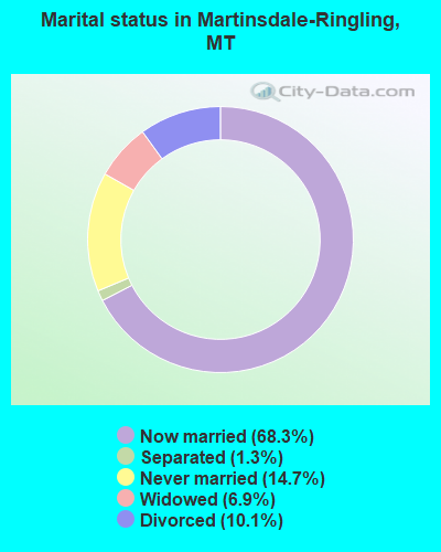
- Never married: 14.7%
- Now married: 68.3%
- Separated: 1.3%
- Widowed: 6.9%
- Divorced: 10.1%
For population 25 years and over in Martinsdale-Ringling:
- High school or higher: 85.9%
- Bachelor's degree or higher: 20.1%
- Graduate or professional degree: 4.2%
- Unemployed: 4.2%
- Mean travel time to work (commute): 15.9 minutes

| Here: | 9.5 |
| Montana average: | 10.4 |
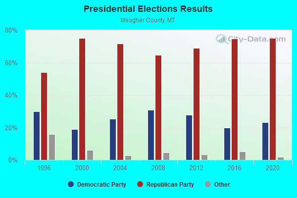
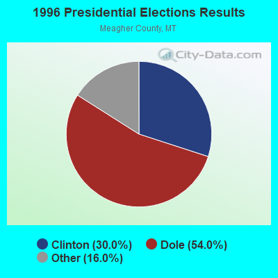

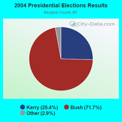
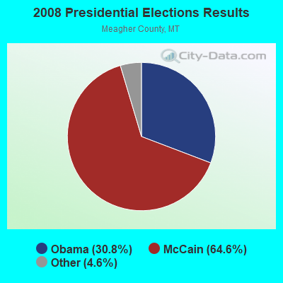

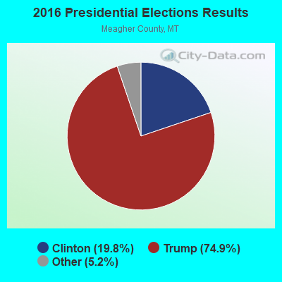
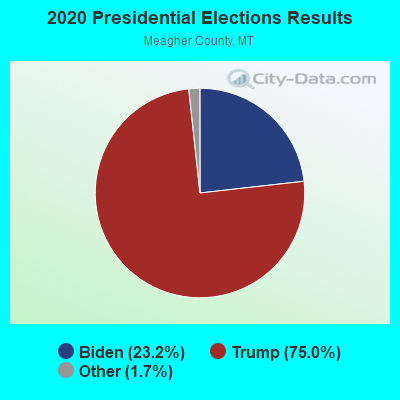
Graphs represent county-level data. Detailed 2008 Election Results
Religion statistics for Martinsdale-Ringling, MT (based on Meagher County data)
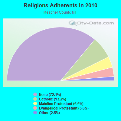
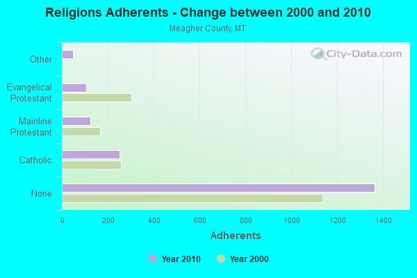
| Religion | Adherents | Congregations |
|---|---|---|
| Catholic | 250 | 1 |
| Mainline Protestant | 124 | 2 |
| Evangelical Protestant | 105 | 4 |
| Other | 48 | 1 |
| None | 1,364 | - |
Food Environment Statistics:
| This county: | 10.56 / 10,000 pop. |
| Montana: | 2.55 / 10,000 pop. |
| Meagher County: | 5.28 / 10,000 pop. |
| Montana: | 4.69 / 10,000 pop. |
| This county: | 26.40 / 10,000 pop. |
| State: | 10.38 / 10,000 pop. |
| Meagher County: | 7.7% |
| Montana: | 7.2% |
| This county: | 25.4% |
| Montana: | 23.1% |
Strongest AM radio stations in Martinsdale-Ringling:
- KGVW (640 AM; 10 kW; BELGRADE, MT; Owner: GALLATIN VALLEY WITNESS, INC.)
- KERR (750 AM; 50 kW; POLSON, MT; Owner: ANDERSON RADIO BROADCASTING, INC.)
- KKGR (680 AM; daytime; 5 kW; EAST HELENA, MT; Owner: KKGR, INC.)
- KMON (560 AM; 5 kW; GREAT FALLS, MT; Owner: COMMONWEALTH LICENSE SUBSIDIARY, LLC)
- KBOZ (1090 AM; 5 kW; BOZEMAN, MT; Owner: REIER BROADCASTING COMPANY, INC.)
- KMTX (950 AM; 5 kW; HELENA, MT; Owner: CAPRI, INC)
- KOFI (1180 AM; 50 kW; KALISPELL, MT; Owner: KOFI, INC.)
- KBOW (550 AM; 5 kW; BUTTE, MT; Owner: BUTTE BROADCASTING INCORPORATED)
- KBOI (670 AM; 50 kW; BOISE, ID; Owner: CITADEL BROADCASTING COMPANY)
- KEIN (1310 AM; 5 kW; GREAT FALLS, MT; Owner: MUNSON RADIO, INC.)
- KGHL (790 AM; 5 kW; BILLINGS, MT; Owner: NEW NORTHWEST BROADCASTERS, LLC)
- KURL (730 AM; 5 kW; BILLINGS, MT; Owner: ELENBAAS MEDIA, INC.)
- KALL (700 AM; 50 kW; NORTH SALT LAKE CITY, UT; Owner: CITICASTERS LICENSES, L.P.)
Strongest FM radio stations in Martinsdale-Ringling:
- KIKF (104.9 FM; CASCADE, MT; Owner: FISHER RADIO REGIONAL GROUP INC.)
- KINX (107.3 FM; GREAT FALLS, MT; Owner: FISHER RADIO REGIONAL GROUP INC.)
- K246AC (97.1 FM; HELENA, MT; Owner: LAST CHANCE PUBLIC RADIO ASSOCIATION)
- K251AC (98.1 FM; HELENA, MT; Owner: BOARD OF REGENTS-MT UNIV. SYSTEM)
- KEHT (100.3 FM; GREAT FALLS, MT; Owner: GEORGE S. FLINN, JR.)
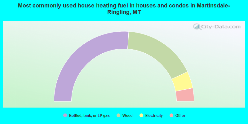
- 52.2%Bottled, tank, or LP gas
- 33.9%Wood
- 7.8%Electricity
- 3.5%Fuel oil, kerosene, etc.
- 2.6%Other fuel
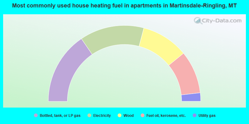
- 30.9%Bottled, tank, or LP gas
- 27.3%Electricity
- 20.0%Wood
- 18.2%Fuel oil, kerosene, etc.
- 3.6%Utility gas
Martinsdale-Ringling compared to Montana state average:
- Unemployed percentage significantly below state average.
- Black race population percentage significantly below state average.
- Hispanic race population percentage below state average.
- Median age above state average.
- Foreign-born population percentage significantly below state average.
- Length of stay since moving in significantly above state average.
- Number of rooms per house significantly below state average.
- House age significantly below state average.
- Number of college students significantly below state average.