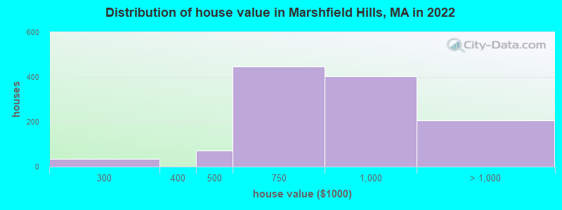
Estimated median house or condo value in 2022: $809,243 (it was $296,400 in 2000)
Marshfield Hills:
$809,243
MA:
$534,700
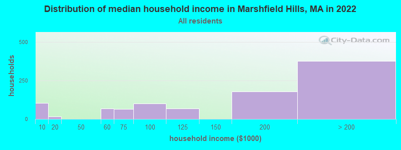
Mean prices in 2022:all housing units: $891,966; detached houses: $879,077March 2022 cost of living index in Marshfield Hills: 129.8 (high, U.S. average is 100)
Latest news from Marshfield Hills, MA collected exclusively by city-data.com from local newspapers, TV, and radio stations
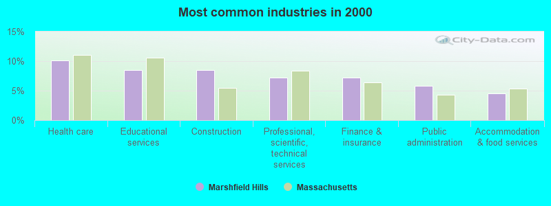
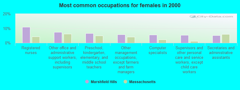
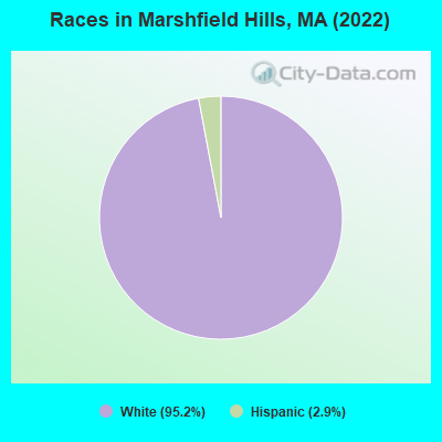
Ancestries: Irish (51.9%), Italian (13.9%), English (10.4%), French (8.8%), Portuguese (4.0%), Greek (3.4%).
Current Local Time: EST time zone
Elevation: 155 feet
Land area: 4.52 square miles.
Population density: 521 people per square mile (low).
174 residents are foreign born (5.8% Europe, 1.1% Latin America).
This place:
7.0%
Massachusetts:
17.6%
Median real estate property taxes paid for housing units with mortgages in 2022: $7,830 (1.0%) Median real estate property taxes paid for housing units with no mortgage in 2022: $8,204 (0.9%)
Nearest city with pop. 50,000+: Weymouth, MA (11.9 miles , pop. 53,988).
Nearest city with pop. 200,000+: Boston, MA (22.1 miles , pop. 589,141).
Nearest city with pop. 1,000,000+: Bronx, NY (185.9 miles , pop. 1,332,650).
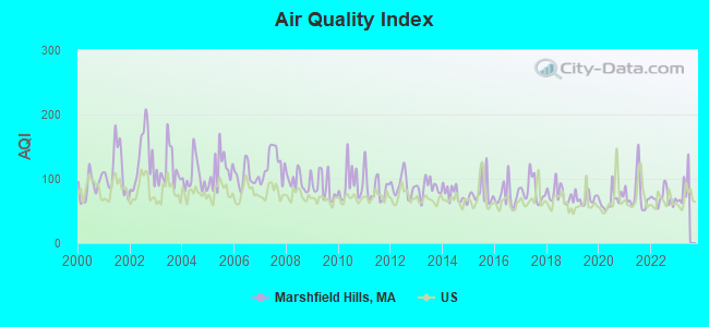
Air Quality Index (AQI) level in 2022 was 70.0. This is about average.
City:
70.0
U.S.:
72.6
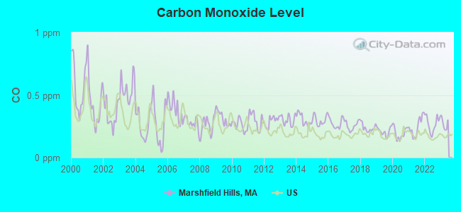
Carbon Monoxide (CO) [ppm] level in 2022 was 0.270. This is about average.Closest monitor was 14.2 miles away from the city center.
City:
0.270
U.S.:
0.251
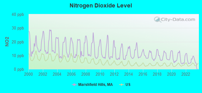
Nitrogen Dioxide (NO2) [ppb] level in 2022 was 6.73. This is worse than average.Closest monitor was 13.5 miles away from the city center.
City:
6.73
U.S.:
5.11
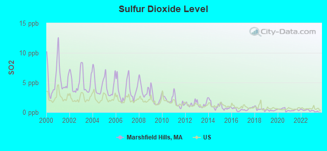
Sulfur Dioxide (SO2) [ppb] level in 2022 was 0.358. This is significantly better than average.Closest monitor was 13.5 miles away from the city center.
City:
0.358
U.S.:
1.515
Ozone [ppb] level in 2022 was 30.7. This is about average.Closest monitor was 13.7 miles away from the city center.
City:
30.7
U.S.:
33.3
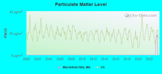
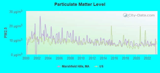
Particulate Matter (PM2.5) [µg/m3] level in 2022 was 7.09. This is about average.Closest monitor was 13.7 miles away from the city center.
City:
7.09
U.S.:
8.11
Tornado activity:
Marshfield Hills-area historical tornado activity is below Massachusetts state average. It is 63% smaller than the overall U.S. average.
On 6/9/1953, a category F4 (max. wind speeds 207-260 mph) tornado 41.9 miles away from the Marshfield Hills place center killed 90 peopleand injured 1228 peopleand causedbetween $50,000,000 and $500,000,000 in damages.
On 6/9/1953, a category F3 (max. wind speeds 158-206 mph) tornado 25.0 miles away from the place center injured 17 peopleand causedbetween $500,000 and $5,000,000 in damages.
Earthquake activity:
Marshfield Hills-area historical earthquake activity is significantly above Massachusetts state average. It is 75% smaller than the overall U.S. average.
On 10/7/1983 at 10:18:46, a magnitude 5.3 (5.1 MB, 5.3 LG, 5.1 ML, Class: Moderate, Intensity: VI - VII) earthquake occurred 221.3 miles away from the city center On 4/20/2002 at 10:50:47, a magnitude 5.3 (5.3 ML, Depth: 3.0 mi) earthquake occurred 221.6 miles away from Marshfield Hills center On 10/16/2012 at 23:12:25, a magnitude 4.7 (4.7 ML, Depth: 10.0 mi, Class: Light, Intensity: IV - V) earthquake occurred 100.6 miles away from the city center On 1/19/1982 at 00:14:42, a magnitude 4.7 (4.5 MB, 4.7 MD, 4.5 LG) earthquake occurred 103.6 miles away from Marshfield Hills center On 4/20/2002 at 10:50:47, a magnitude 5.2 (5.2 MB, 4.2 MS, 5.2 MW, 5.0 MW) earthquake occurred 221.0 miles away from the city center On 8/22/1992 at 12:20:32, a magnitude 4.8 (4.8 MB, 3.8 MS, 4.7 LG, Depth: 6.2 mi) earthquake occurred 211.3 miles away from Marshfield Hills center Magnitude types: regional Lg-wave magnitude (LG), body-wave magnitude (MB), duration magnitude (MD), local magnitude (ML), surface-wave magnitude (MS), moment magnitude (MW)
Natural disasters:
The number of natural disasters in Plymouth County (26) is a lot greater than the US average (15). Major Disasters (Presidential) Declared: 17 Emergencies Declared: 9
Causes of natural disasters: Floods: 11, Storms: 9, Hurricanes: 7, Snows: 3, Snowstorms: 3, Blizzards: 2, Winter Storms: 2, Heavy Rain: 1, Snowfall: 1, Tropical Storm: 1, Wind: 1 (Note: some incidents may be assigned to more than one category).
Hospitals and medical centers near Marshfield Hills:
LIFE CARE CENTER OF THE SOUTH SHORE (Nursing Home, about 3 miles away; SCITUATE, MA)
SCITUATE OCEAN MANOR (Nursing Home, about 3 miles away; SCITUATE, MA)
CARDIGAN NURSING AND REHABILITATION CENTER (Nursing Home, about 3 miles away; SCITUATE, MA)
NIGHTINGALE HOME HEALTHCARE OF MASSACHUSETTS INC (Home Health Center, about 3 miles away; MARSHFIELD, MA)
PEMBROKE HOSPITAL (Hospital, about 4 miles away; PEMBROKE, MA)
STETSON MANOR NURSING HOME (Nursing Home, about 5 miles away; NORWELL, MA)
NORTH RIVER NURSING HOME (Nursing Home, about 5 miles away; PEMBROKE, MA)
Operable nuclear power plant near Marshfield Hills:
14 miles: Pilgrim in Plymouth, MA.
Colleges/universities with over 2000 students nearest to Marshfield Hills:
Massasoit Community College (about 15 miles; Brockton, MA; Full-time enrollment: 5,442)
Quincy College (about 16 miles; Quincy, MA; FT enrollment: 3,184)
Bridgewater State University (about 17 miles; Bridgewater, MA; FT enrollment: 9,802)
Stonehill College (about 19 miles; Easton, MA; FT enrollment: 2,563)
University of Massachusetts-Boston (about 20 miles; Boston, MA; FT enrollment: 12,625)
Curry College (about 21 miles; Milton, MA; FT enrollment: 2,586)
Suffolk University (about 23 miles; Boston, MA; FT enrollment: 6,982)
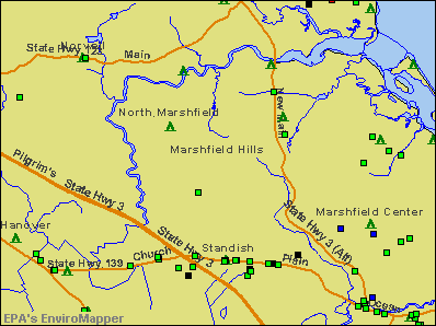
Streams, rivers, and creeks: Broad Creek (A), Branch Creek (B), Bares Brook (C), South River (D), Littles Creek (E), Macombers Creek (F), North River (G), Hannah Eames Brook (H). Display/hide their locations on the map
Plymouth County has a predicted average indoor radon screening level between 2 and 4 pCi/L (pico curies per liter) - Moderate Potential
Average household size:
This place:
2.8 people
Massachusetts:
2.5 people
Percentage of family households:
This place:
80.5%
Whole state:
63.0%
Percentage of households with unmarried partners:
This place:
5.6%
Whole state:
7.0%
Likely homosexual households (counted as self-reported same-sex unmarried-partner households)
Lesbian couples: 0.6% of all households
Gay men: 1.5% of all households
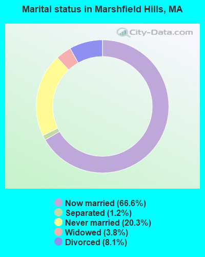
For population 15 years and over in Marshfield Hills:
Never married: 20.3%
Now married: 66.6%
Separated: 1.2%
Widowed: 3.8%
Divorced: 8.1%
For population 25 years and over in Marshfield Hills:
Religion statistics for Marshfield Hills, MA (based on Plymouth County data)
Religion
Adherents
Congregations
Catholic
165,985
35
Mainline Protestant
23,724
91
Evangelical Protestant
13,159
96
Other
6,129
43
Orthodox
1,140
3
Black Protestant
611
5
None
284,171
-
Source: Clifford Grammich, Kirk Hadaway, Richard Houseal, Dale E.Jones, Alexei Krindatch, Richie Stanley and Richard H.Taylor. 2012. 2010 U.S.Religion Census: Religious Congregations & Membership Study. Association of Statisticians of American Religious Bodies. Jones, Dale E., et al. 2002. Congregations and Membership in the United States 2000. Nashville, TN: Glenmary Research Center. Graphs represent county-level data
75,174Total future (year 2031) average daily traffic
FCC Registered Antenna Towers:
3
Edward G Roach, 1 Km Sse (Lat: 42.133611 Lon: -70.732500), Type: 81.0, Overall height: 73 m, Registrant: Sba Properties, Inc., Eroach@sbasite.Com, , Boca -Raton, Phone: (561) 995-7670
Edward G Roach, 1 Km Sse (Lat: 42.133611 Lon: -70.732500), Type: 81.0, Overall height: 73 m, Registrant: Sba Properties, Inc., Eroach@sbasite.Com, , Boca -Raton, Phone: (561) 995-7670
1 Km Sse (Lat: 42.133611 Lon: -70.732500), Type: 81.0, Overall height: 73 m, Registrant: New England Telephone And Telegraph, Notes.Acapewel@a50vm1.Trg.Nynex.Com, , Marlb-orough, Phone: (508) 627-1173
FCC Registered Microwave Towers:
1
MARSHFIELD, 0.9 Mile Sse Of (Lat: 42.133694 Lon: -70.732528), Overall height: 80.8 m, Call Sign: KVH81, Assigned Frequencies: 6004.50 MHz, 5945.20 MHz, 6004.50 MHz, 6063.80 MHz, 6123.10 MHz, 6123.10 MHz, Grant Date: 09/19/1985, Expiration Date: 08/05/1996, Cancellation Date: 08/05/1996, Registrant: New England Telephone And Telegraph Company, 125 High St Rm 515, Boston, MA 02110
FCC Registered Paging Towers:
1
1 Km Sse (Lat: 42.133611 Lon: -70.732500), Type: Tower, Structure height: 73 m, Overall height: 81 m, Call Sign: KNKG540, Assigned Frequencies: 931.787 MHz, Grant Date: 05/11/1999, Expiration Date: 04/01/2009, Cancellation Date: 04/21/2004, Certifier: Paul H Kuzia, Registrant: Wilkinson Barker Knauer, LLP, 2300 N Street, N.W., 7th Floor, Washington, DC 20037, Phone: (202) 783-4141, Fax: (202) 783-5851, Email:
FCC Registered Amateur Radio Licenses:
6
Call Sign: AA1FD, Previous Call Sign: W8YPJ, Licensee ID: L00631784, Grant Date: 01/31/2003, Expiration Date: 01/31/2013, Cancellation Date: 11/28/2012, Certifier: Peter P Roper, Registrant: Peter P Roper, 34 Deerhill Ln, Marshfield Hills, MA 02051
Call Sign: N1LXQ, Licensee ID: L00326775, Grant Date: 01/23/2012, Expiration Date: 04/07/2022, Certifier: Christerpher Perry, Registrant: Christerpher Perry, 846 Summer St, Marshfield Hills, MA 02051
Call Sign: KB1PBU, Licensee ID: L01287255, Grant Date: 05/24/2007, Expiration Date: 05/24/2017, Cancellation Date: 05/25/2019, Certifier: Joel P Clark, Registrant: Joel P Clark, Marshfield Hills, MA 02051
Call Sign: KB1QCH, Licensee ID: L01379358, Grant Date: 03/13/2008, Expiration Date: 03/13/2018, Cancellation Date: 03/14/2020, Certifier: Daniel K Ryan, Registrant: Daniel K Ryan, Marshfield Hills, MA 02051
Call Sign: KC1TVN, Licensee ID: L02681769, Grant Date: 12/12/2023, Expiration Date: 12/12/2033, Cancellation Date: 02/06/2024, Certifier: Matthew S Comeau, Registrant: Matthew S Comeau, Marshfield Hills, MA 02051
Call Sign: W1AXO, Previous Call Sign: KC1TVN, Licensee ID: L02681769, Grant Date: 02/06/2024, Expiration Date: 02/06/2034, Certifier: Matthew S Comeau, Registrant: Matthew S Comeau, Marshfield Hills, MA 02051
FAA Registered Aircraft:
1
Aircraft: CESSNA 182P (Category: Land, Seats: 4, Weight: Up to 12,499 Pounds, Speed: 120 mph), Engine: CONT MOTOR O-470 SERIES (230 HP) (Reciprocating) N-Number: 52624, N52624, N-52624, Serial Number: 18262721, Year manufactured: 1973, Airworthiness Date: 12/29/1973, Certificate Issue Date: 02/20/2014 Registrant (LLC): Skylane LLC, Po Box 200, Marshfield Hills, MA 02051
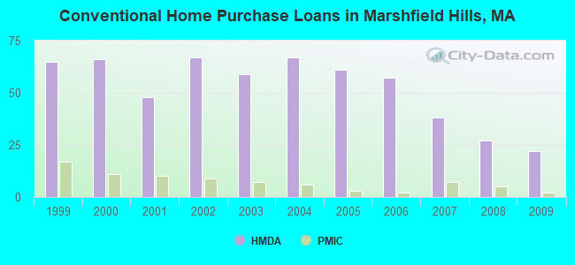
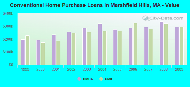
Home Mortgage Disclosure Act Aggregated Statistics For Year 2009 (Based on 2 partial tracts)
A) FHA, FSA/RHS & VA Home Purchase Loans
B) Conventional Home Purchase Loans
C) Refinancings
D) Home Improvement Loans
F) Non-occupant Loans on < 5 Family Dwellings (A B C & D)
Number
Average Value
Number
Average Value
Number
Average Value
Number
Average Value
Number
Average Value
LOANS ORIGINATED
10
$292,227
22
$295,698
142
$281,173
5
$173,752
4
$270,882
APPLICATIONS APPROVED, NOT ACCEPTED
1
$216,030
3
$348,770
7
$262,327
2
$79,910
0
$0
APPLICATIONS DENIED
1
$341,530
3
$274,687
36
$321,040
2
$205,330
2
$363,320
APPLICATIONS WITHDRAWN
1
$170,020
3
$240,180
24
$293,848
0
$0
1
$353,680
FILES CLOSED FOR INCOMPLETENESS
0
$0
1
$363,430
5
$356,766
1
$167,320
0
$0
Aggregated Statistics For Year 2008 (Based on 2 partial tracts)
A) FHA, FSA/RHS & VA Home Purchase Loans
B) Conventional Home Purchase Loans
C) Refinancings
D) Home Improvement Loans
F) Non-occupant Loans on < 5 Family Dwellings (A B C & D)
Number
Average Value
Number
Average Value
Number
Average Value
Number
Average Value
Number
Average Value
LOANS ORIGINATED
3
$331,413
27
$337,849
63
$311,835
8
$113,351
3
$600,843
APPLICATIONS APPROVED, NOT ACCEPTED
0
$0
2
$308,315
11
$321,555
0
$0
0
$0
APPLICATIONS DENIED
0
$0
5
$335,902
21
$335,839
3
$106,180
1
$441,490
APPLICATIONS WITHDRAWN
0
$0
5
$452,338
14
$331,716
1
$153,040
1
$283,420
FILES CLOSED FOR INCOMPLETENESS
0
$0
0
$0
4
$329,490
0
$0
0
$0
Aggregated Statistics For Year 2007 (Based on 2 partial tracts)
B) Conventional Home Purchase Loans
C) Refinancings
D) Home Improvement Loans
F) Non-occupant Loans on < 5 Family Dwellings (A B C & D)
Number
Average Value
Number
Average Value
Number
Average Value
Number
Average Value
LOANS ORIGINATED
38
$293,018
71
$284,238
11
$105,156
6
$251,588
APPLICATIONS APPROVED, NOT ACCEPTED
5
$356,048
11
$284,753
1
$154,570
1
$51,130
APPLICATIONS DENIED
3
$342,860
32
$341,357
3
$160,487
1
$328,930
APPLICATIONS WITHDRAWN
5
$349,700
17
$365,612
1
$321,770
1
$517,960
FILES CLOSED FOR INCOMPLETENESS
0
$0
6
$413,525
0
$0
0
$0
Aggregated Statistics For Year 2006 (Based on 2 partial tracts)
B) Conventional Home Purchase Loans
C) Refinancings
D) Home Improvement Loans
F) Non-occupant Loans on < 5 Family Dwellings (A B C & D)
Number
Average Value
Number
Average Value
Number
Average Value
Number
Average Value
LOANS ORIGINATED
57
$287,026
99
$273,132
22
$112,808
10
$305,544
APPLICATIONS APPROVED, NOT ACCEPTED
7
$255,436
14
$235,296
2
$81,240
1
$240,130
APPLICATIONS DENIED
9
$258,860
35
$302,101
6
$128,795
1
$180,440
APPLICATIONS WITHDRAWN
8
$337,481
25
$289,026
0
$0
1
$320,780
FILES CLOSED FOR INCOMPLETENESS
1
$276,590
9
$271,136
1
$227,090
0
$0
Aggregated Statistics For Year 2005 (Based on 2 partial tracts)
B) Conventional Home Purchase Loans
C) Refinancings
D) Home Improvement Loans
F) Non-occupant Loans on < 5 Family Dwellings (A B C & D)
Number
Average Value
Number
Average Value
Number
Average Value
Number
Average Value
LOANS ORIGINATED
61
$276,652
116
$270,146
17
$181,039
9
$267,378
APPLICATIONS APPROVED, NOT ACCEPTED
7
$257,771
8
$291,024
2
$88,870
1
$162,940
APPLICATIONS DENIED
6
$208,295
34
$285,544
4
$88,142
4
$224,412
APPLICATIONS WITHDRAWN
12
$256,995
26
$253,465
4
$118,060
4
$205,470
FILES CLOSED FOR INCOMPLETENESS
4
$196,060
10
$283,195
1
$70,470
0
$0
Aggregated Statistics For Year 2004 (Based on 2 partial tracts)
A) FHA, FSA/RHS & VA Home Purchase Loans
B) Conventional Home Purchase Loans
C) Refinancings
D) Home Improvement Loans
F) Non-occupant Loans on < 5 Family Dwellings (A B C & D)
Number
Average Value
Number
Average Value
Number
Average Value
Number
Average Value
Number
Average Value
LOANS ORIGINATED
1
$187,040
67
$321,106
133
$259,679
18
$172,700
6
$241,437
APPLICATIONS APPROVED, NOT ACCEPTED
0
$0
11
$320,059
12
$251,999
3
$72,100
0
$0
APPLICATIONS DENIED
0
$0
8
$247,666
25
$261,283
5
$94,654
1
$215,370
APPLICATIONS WITHDRAWN
0
$0
7
$245,939
28
$239,188
1
$231,260
1
$125,280
FILES CLOSED FOR INCOMPLETENESS
0
$0
2
$220,135
8
$271,608
1
$47,180
0
$0
Aggregated Statistics For Year 2003 (Based on 2 partial tracts)
A) FHA, FSA/RHS & VA Home Purchase Loans
B) Conventional Home Purchase Loans
C) Refinancings
D) Home Improvement Loans
F) Non-occupant Loans on < 5 Family Dwellings (A B C & D)
Number
Average Value
Number
Average Value
Number
Average Value
Number
Average Value
Number
Average Value
LOANS ORIGINATED
1
$203,480
59
$287,636
366
$219,594
12
$91,376
10
$213,012
APPLICATIONS APPROVED, NOT ACCEPTED
0
$0
5
$317,080
38
$217,801
2
$111,615
0
$0
APPLICATIONS DENIED
0
$0
7
$368,137
47
$239,991
3
$106,540
3
$174,737
APPLICATIONS WITHDRAWN
0
$0
3
$520,480
33
$208,506
1
$97,620
0
$0
FILES CLOSED FOR INCOMPLETENESS
0
$0
1
$377,560
6
$217,108
0
$0
0
$0
Aggregated Statistics For Year 2002 (Based on 2 partial tracts)
A) FHA, FSA/RHS & VA Home Purchase Loans
B) Conventional Home Purchase Loans
C) Refinancings
D) Home Improvement Loans
F) Non-occupant Loans on < 5 Family Dwellings (A B C & D)
Number
Average Value
Number
Average Value
Number
Average Value
Number
Average Value
Number
Average Value
LOANS ORIGINATED
1
$150,870
67
$256,664
258
$211,568
13
$80,941
8
$218,874
APPLICATIONS APPROVED, NOT ACCEPTED
0
$0
4
$246,728
31
$187,995
3
$55,707
0
$0
APPLICATIONS DENIED
0
$0
5
$154,462
36
$235,519
7
$59,984
2
$175,965
APPLICATIONS WITHDRAWN
0
$0
3
$251,570
28
$210,082
2
$52,600
0
$0
FILES CLOSED FOR INCOMPLETENESS
0
$0
2
$245,425
7
$219,527
0
$0
0
$0
Aggregated Statistics For Year 2001 (Based on 2 partial tracts)
A) FHA, FSA/RHS & VA Home Purchase Loans
B) Conventional Home Purchase Loans
C) Refinancings
D) Home Improvement Loans
F) Non-occupant Loans on < 5 Family Dwellings (A B C & D)
Number
Average Value
Number
Average Value
Number
Average Value
Number
Average Value
Number
Average Value
LOANS ORIGINATED
2
$109,535
48
$235,912
202
$191,775
12
$54,224
6
$152,607
APPLICATIONS APPROVED, NOT ACCEPTED
0
$0
5
$344,502
18
$185,144
3
$33,210
0
$0
APPLICATIONS DENIED
0
$0
4
$239,175
23
$165,167
5
$39,652
1
$217,920
APPLICATIONS WITHDRAWN
0
$0
6
$228,763
21
$201,177
2
$43,600
1
$124,200
FILES CLOSED FOR INCOMPLETENESS
0
$0
0
$0
3
$200,170
1
$41,310
0
$0
Aggregated Statistics For Year 2000 (Based on 2 partial tracts)
A) FHA, FSA/RHS & VA Home Purchase Loans
B) Conventional Home Purchase Loans
C) Refinancings
D) Home Improvement Loans
F) Non-occupant Loans on < 5 Family Dwellings (A B C & D)
Number
Average Value
Number
Average Value
Number
Average Value
Number
Average Value
Number
Average Value
LOANS ORIGINATED
3
$103,833
66
$191,819
41
$146,283
14
$41,003
4
$122,198
APPLICATIONS APPROVED, NOT ACCEPTED
0
$0
7
$244,357
6
$117,410
4
$30,278
1
$77,890
APPLICATIONS DENIED
0
$0
8
$191,320
15
$131,609
5
$47,626
1
$162,070
APPLICATIONS WITHDRAWN
0
$0
4
$327,308
15
$129,403
1
$45,530
0
$0
FILES CLOSED FOR INCOMPLETENESS
0
$0
1
$291,880
2
$162,895
0
$0
0
$0
Aggregated Statistics For Year 1999 (Based on 2 partial tracts)
A) FHA, FSA/RHS & VA Home Purchase Loans
B) Conventional Home Purchase Loans
C) Refinancings
D) Home Improvement Loans
F) Non-occupant Loans on < 5 Family Dwellings (A B C & D)


 Recent articles from our blog. Our writers, many of them Ph.D. graduates or candidates, create easy-to-read articles on a wide variety of topics.

 (11.9 miles