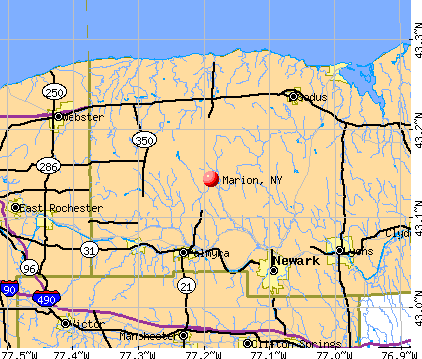
Marion, New York
Submit your own pictures of this town and show them to the world
- OSM Map
- General Map
- Google Map
- MSN Map
Population change since 2000: -4.6%
 |
| Males: 2,314 | |
| Females: 2,432 |
| Median resident age: | 41.1 years |
| New York median age: | 40.7 years |
Zip codes: 14505.
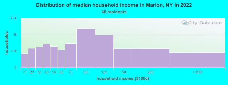
| Marion: | $77,595 |
| NY: | $79,557 |
Estimated per capita income in 2022: $34,230 (it was $18,414 in 2000)
Marion town income, earnings, and wages data
Estimated median house or condo value in 2022: $172,142 (it was $87,900 in 2000)
| Marion: | $172,142 |
| NY: | $400,400 |
Mean prices in 2022: all housing units: $177,416; detached houses: $194,685; townhouses or other attached units: $174,832; in 2-unit structures: $148,309; in 3-to-4-unit structures: $91,913; in 5-or-more-unit structures: $195,849; mobile homes: $52,467; occupied boats, rvs, vans, etc.: $19,284
Detailed information about poverty and poor residents in Marion, NY
Compare current foreclosures near Marion, NY:
| Photo | Address | Area | Beds / Baths | Price | Details |
|---|---|---|---|---|---|

|
#1
Witherden Rd
Marion, NY 14505
|
1,008 sq. feet
|
1 baths 3 beds |
show details | |

|
#2
Steel Point Rd
Marion, NY 14505
|
1,624 sq. feet
|
1 baths 2 beds |
show details | |

|
#3
Huntley Rd Lot 58
Marion, NY 14505
|
- sq. feet
|
- baths - beds |
show details | |

|
#4
Five Mile Line Rd
Webster, NY 14580
|
821 sq. feet
|
2 baths 3 beds |
show details | |

|
#5
Filkins Rd
Newark, NY 14513
|
3,248 sq. feet
|
2 baths 3 beds |
show details | |

|
#6
Glasgow St
Clyde, NY 14433
|
1,507 sq. feet
|
2 baths 2 beds |
show details | |

|
#7
Bennett St
Williamson, NY 14589
|
1,026 sq. feet
|
1 baths 3 beds |
show details | |

|
#8
North Ave
Newark, NY 14513
|
864 sq. feet
|
1 baths 3 beds |
show details | |

|
#9
Kathlyn Ave
Phelps, NY 14532
|
1,677 sq. feet
|
2 baths 3 beds |
show details | |

|
#10
Moseley Rd
Fairport, NY 14450
|
1,512 sq. feet
|
2 baths 3 beds |
show details |
| Photo | Address | Area | Beds / Baths | Price | Details |
|---|---|---|---|---|---|

|
#11
Lenora Ln
Webster, NY 14580
|
1,360 sq. feet
|
1 baths 3 beds |
show details | |

|
#12
Lovers Ln
Clyde, NY 14433
|
1,836 sq. feet
|
1 baths 4 beds |
show details | |

|
#13
County Road 19
Shortsville, NY 14548
|
720 sq. feet
|
1 baths 2 beds |
show details | |

|
#14
Sandhill Rd
Shortsville, NY 14548
|
1,720 sq. feet
|
1 baths 4 beds |
show details | |

|
#15
Booth Street Ext
Shortsville, NY 14548
|
1,040 sq. feet
|
1 baths 3 beds |
show details | |

|
#16
Pioneer Rd
Shortsville, NY 14548
|
540 sq. feet
|
1 baths 2 beds |
show details | |

|
#17
Springwood Dr
Webster, NY 14580
|
1,125 sq. feet
|
1 baths 2 beds |
show details | |

|
#18
Golf View Rise
Victor, NY 14564
|
4,191 sq. feet
|
4 baths 6 beds |
show details | |

|
#19
Lake Rd
Phelps, NY 14532
|
1,500 sq. feet
|
1 baths 4 beds |
show details | |

|
#20
Heron Way S
Fairport, NY 14450
|
840 sq. feet
|
1 baths 2 beds |
show details |
| Photo | Address | Area | Beds / Baths | Price | Details |
|---|---|---|---|---|---|

|
#21
Clearview Dr
Penfield, NY 14526
|
1,646 sq. feet
|
1 baths 3 beds |
show details | |

|
#22
Main St
Phelps, NY 14532
|
558 sq. feet
|
1 baths 1 beds |
show details | |

|
#23
5th Mile Line Rd
Penfield, NY 14526
|
1,305 sq. feet
|
1 baths 2 beds |
show details | |

|
#24
Gannett Rd
Farmington, NY 14425
|
1,008 sq. feet
|
1 baths 3 beds |
show details | |

|
#25
Belmont Dr
Farmington, NY 14425
|
1,963 sq. feet
|
2 baths 3 beds |
show details | |

|
#26
Taylor Rd
Clifton Springs, NY 14432
|
2,456 sq. feet
|
1 baths 4 beds |
show details | |

|
#27
State Route 14
Lyons, NY 14489
|
960 sq. feet
|
2 baths 3 beds |
show details | |

|
#28
Palmyra St
Shortsville, NY 14548
|
2,522 sq. feet
|
2 baths 4 beds |
show details | |

|
#29
Silver St
Clifton Springs, NY 14432
|
1,543 sq. feet
|
1 baths 2 beds |
show details | |

|
#30
Crowley Rd
Farmington, NY 14425
|
1,416 sq. feet
|
1 baths 4 beds |
show details |
| Photo | Address | Area | Beds / Baths | Price | Details |
|---|---|---|---|---|---|

|
#31
W Main St
Clifton Springs, NY 14432
|
2,048 sq. feet
|
1 baths 4 beds |
show details | |

|
#32
Falkey Rd
Phelps, NY 14532
|
3,198 sq. feet
|
2 baths 4 beds |
show details | |

|
#33
Camberley Pl
Penfield, NY 14526
|
1,820 sq. feet
|
2 baths 3 beds |
show details | |

|
#34
High St # A
Fairport, NY 14450
|
2,461 sq. feet
|
2 baths 7 beds |
show details | |

|
#35
Stonegate Dr
Webster, NY 14580
|
2,052 sq. feet
|
2 baths 3 beds |
show details | |

|
#36
Morning Glory Dr
Webster, NY 14580
|
2,524 sq. feet
|
2 baths 4 beds |
show details | |

|
#37
Railroad Ave
Clifton Springs, NY 14432
|
564 sq. feet
|
1 baths 3 beds |
show details | |

|
#38
Holley Rd
Webster, NY 14580
|
1,764 sq. feet
|
2 baths 5 beds |
show details | |

|
#39
Kendall St
Clifton Springs, NY 14432
|
1,896 sq. feet
|
1 baths 3 beds |
show details | |

|
#40
Brownsville Rd
Farmington, NY 14425
|
1,684 sq. feet
|
1 baths 3 beds |
show details |
| Photo | Address | Area | Beds / Baths | Price | Details |
|---|---|---|---|---|---|

|
#41
E Main St
Clifton Springs, NY 14432
|
3,552 sq. feet
|
3 baths 4 beds |
show details | |

|
#42
Silver St
Clifton Springs, NY 14432
|
1,380 sq. feet
|
1 baths 3 beds |
show details | |

|
#43
Cline Rd
Victor, NY 14564
|
1,374 sq. feet
|
1 baths 3 beds |
show details | |

|
#44
Covell Rd
Clyde, NY 14433
|
1,232 sq. feet
|
2 baths 2 beds |
show details | |

|
#45
Robin Hood Ln
Webster, NY 14580
|
1,410 sq. feet
|
1 baths 3 beds |
show details | |

|
#46
State Route 88
Phelps, NY 14532
|
1,957 sq. feet
|
1 baths 3 beds |
show details | |

|
#47
East Ave
Shortsville, NY 14548
|
1,414 sq. feet
|
1 baths 3 beds |
show details | |

|
#48
Wall Rd
Webster, NY 14580
|
2,000 sq. feet
|
1 baths 4 beds |
show details | |

|
#49
E Main St
Shortsville, NY 14548
|
2,218 sq. feet
|
1 baths 4 beds |
show details | |

|
Check over 1 million property listings on Foreclosure.com!
|
browse all offers | |||


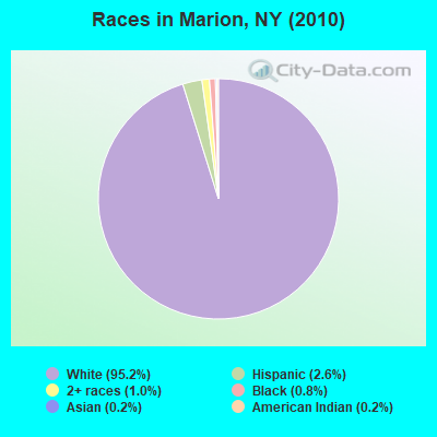
- 4,51795.2%White alone
- 1222.6%Hispanic
- 461.0%Two or more races
- 400.8%Black alone
- 100.2%American Indian alone
- 110.2%Asian alone
Races in Marion detailed stats: ancestries, foreign born residents, place of birth
According to our research of New York and other state lists, there were 4 registered sex offenders living in Marion, New York as of May 09, 2024.
The ratio of all residents to sex offenders in Marion is 1,187 to 1.
The ratio of registered sex offenders to all residents in this city is lower than the state average.
 Recent articles from our blog. Our writers, many of them Ph.D. graduates or candidates, create easy-to-read articles on a wide variety of topics.

 | Buffalo and Rochester: peers or not (39 replies) |
| For those interested in Technology and Economic activity in Upstate NY... (2811 replies) |
| smaller Upstate NY cities and towns/African American communities (5974 replies) |
| Big Move to Binghamton... honest opinions (17 replies) |
| Luxury style housing (14 replies) |
| Goodbye long island, hello myrtle beach (227 replies) |
Latest news from Marion, NY collected exclusively by city-data.com from local newspapers, TV, and radio stations
Ancestries: German (23.5%), Dutch (21.3%), English (17.5%), Irish (13.6%), United States (8.6%), Italian (7.2%).
Current Local Time: EST time zone
Elevation: 463 feet
Land area: 29.2 square miles.
Population density: 163 people per square mile (very low).
83 residents are foreign born
| This town: | 1.7% |
| New York: | 20.4% |
| Marion town: | 3.0% ($2,610) |
| New York: | 1.9% ($2,847) |
Nearest city with pop. 50,000+: Irondequoit, NY  (20.0 miles , pop. 52,354).
Nearest city with pop. 200,000+: Rochester, NY (21.5 miles , pop. 219,773).
Nearest city with pop. 1,000,000+: Bronx, NY (233.3 miles , pop. 1,332,650).
Nearest cities:
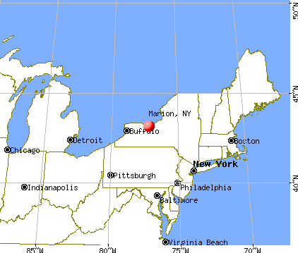
), ), ), )Latitude: 43.15 N, Longitude: 77.18 W
Area code: 315

Single-family new house construction building permits:
- 2022: 1 building, cost: $375,000
- 2021: 4 buildings, average cost: $229,800
- 2020: 5 buildings, average cost: $179,200
- 2019: 4 buildings, average cost: $100,300
- 2018: 5 buildings, average cost: $225,200
- 2017: 4 buildings, average cost: $126,500
- 2016: 1 building, cost: $185,000
- 2015: 1 building, cost: $75,000
- 2014: 3 buildings, average cost: $150,700
- 2013: 4 buildings, average cost: $180,700
- 2012: 2 buildings, average cost: $115,000
- 2011: 2 buildings, average cost: $215,000
- 2010: 4 buildings, average cost: $215,800
- 2009: 3 buildings, average cost: $149,700
- 2007: 8 buildings, average cost: $142,300
- 2006: 10 buildings, average cost: $146,300
- 2005: 10 buildings, average cost: $126,200
- 2004: 6 buildings, average cost: $156,700
- 2003: 9 buildings, average cost: $146,800
- 2002: 6 buildings, average cost: $175,800
- 2001: 6 buildings, average cost: $139,200
- 2000: 12 buildings, average cost: $113,700
- 1999: 11 buildings, average cost: $140,400
- 1998: 9 buildings, average cost: $92,200
- 1997: 12 buildings, average cost: $109,100
| Here: | 4.0% |
| New York: | 4.4% |
- Educational services (10.5%)
- Machinery (10.5%)
- Health care (9.8%)
- Construction (6.2%)
- Accommodation & food services (5.0%)
- Metal & metal products (3.9%)
- Food & beverage stores (3.7%)
- Machinery (16.9%)
- Construction (10.1%)
- Metal & metal products (5.9%)
- Repair & maintenance (4.2%)
- Accommodation & food services (4.1%)
- Educational services (3.9%)
- Food (3.8%)
- Health care (18.9%)
- Educational services (17.7%)
- Accommodation & food services (6.1%)
- Finance & insurance (5.6%)
- Food & beverage stores (4.6%)
- Social assistance (4.1%)
- Professional, scientific, technical services (3.9%)
- Other production occupations, including supervisors (6.9%)
- Metal workers and plastic workers (5.5%)
- Electrical equipment mechanics and other installation, maintenance, and repair workers, including supervisors (4.3%)
- Other office and administrative support workers, including supervisors (3.6%)
- Secretaries and administrative assistants (3.4%)
- Building and grounds cleaning and maintenance occupations (3.0%)
- Driver/sales workers and truck drivers (2.9%)
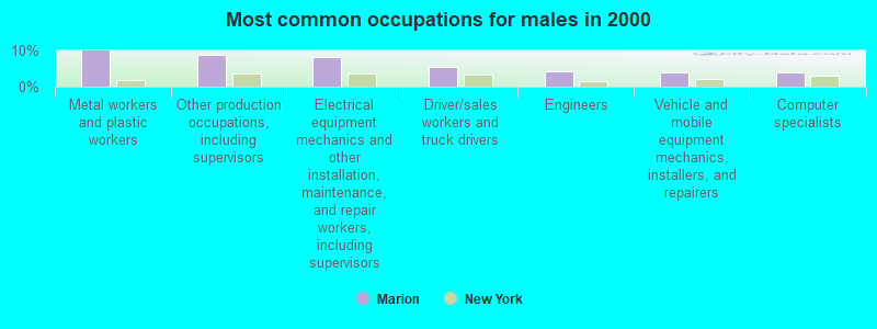
- Metal workers and plastic workers (10.0%)
- Other production occupations, including supervisors (8.8%)
- Electrical equipment mechanics and other installation, maintenance, and repair workers, including supervisors (8.3%)
- Driver/sales workers and truck drivers (5.5%)
- Engineers (4.2%)
- Vehicle and mobile equipment mechanics, installers, and repairers (4.1%)
- Computer specialists (3.9%)
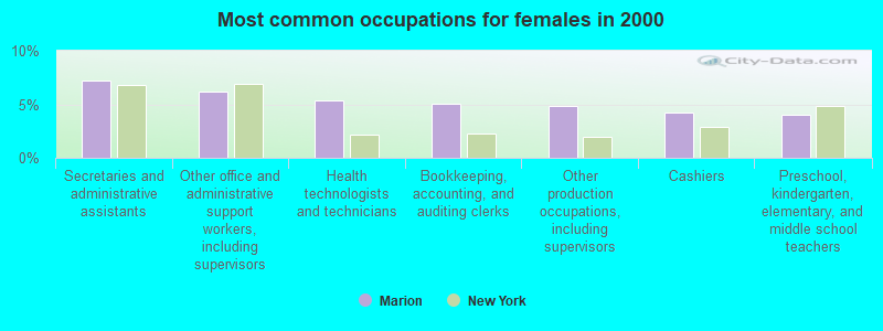
- Secretaries and administrative assistants (7.2%)
- Other office and administrative support workers, including supervisors (6.2%)
- Health technologists and technicians (5.4%)
- Bookkeeping, accounting, and auditing clerks (5.1%)
- Other production occupations, including supervisors (4.9%)
- Cashiers (4.2%)
- Preschool, kindergarten, elementary, and middle school teachers (4.0%)
Average climate in Marion, New York
Based on data reported by over 4,000 weather stations


(lower is better)
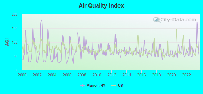
Air Quality Index (AQI) level in 2023 was 88.5. This is worse than average.
| City: | 88.5 |
| U.S.: | 72.6 |
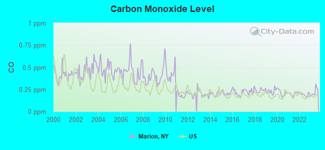
Carbon Monoxide (CO) [ppm] level in 2023 was 0.225. This is about average. Closest monitor was 18.3 miles away from the city center.
| City: | 0.225 |
| U.S.: | 0.251 |
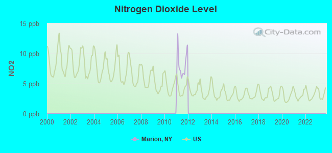
Nitrogen Dioxide (NO2) [ppb] level in 2011 was 8.11. This is significantly worse than average. Closest monitor was 18.3 miles away from the city center.
| City: | 8.11 |
| U.S.: | 5.11 |
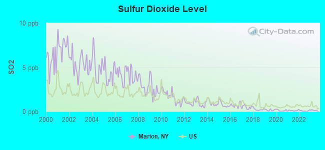
Sulfur Dioxide (SO2) [ppb] level in 2023 was 0.128. This is significantly better than average. Closest monitor was 12.9 miles away from the city center.
| City: | 0.128 |
| U.S.: | 1.515 |
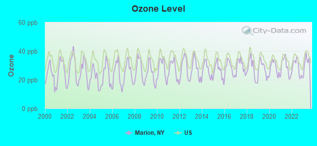
Ozone [ppb] level in 2023 was 31.3. This is about average. Closest monitor was 18.3 miles away from the city center.
| City: | 31.3 |
| U.S.: | 33.3 |
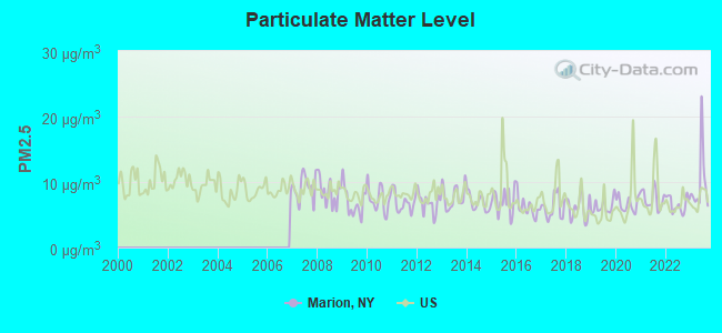
Particulate Matter (PM2.5) [µg/m3] level in 2023 was 9.83. This is worse than average. Closest monitor was 18.3 miles away from the city center.
| City: | 9.83 |
| U.S.: | 8.11 |
Earthquake activity:
Marion-area historical earthquake activity is significantly above New York state average. It is 68% smaller than the overall U.S. average.On 10/7/1983 at 10:18:46, a magnitude 5.3 (5.1 MB, 5.3 LG, 5.1 ML, Class: Moderate, Intensity: VI - VII) earthquake occurred 152.8 miles away from the city center
On 4/20/2002 at 10:50:47, a magnitude 5.3 (5.3 ML, Depth: 3.0 mi) earthquake occurred 197.7 miles away from the city center
On 4/20/2002 at 10:50:47, a magnitude 5.2 (5.2 MB, 4.2 MS, 5.2 MW, 5.0 MW) earthquake occurred 196.0 miles away from Marion center
On 9/25/1998 at 19:52:52, a magnitude 5.2 (4.8 MB, 4.3 MS, 5.2 LG, 4.5 MW, Depth: 3.1 mi) earthquake occurred 200.5 miles away from Marion center
On 8/23/2011 at 17:51:04, a magnitude 5.8 (5.8 MW, Depth: 3.7 mi) earthquake occurred 364.9 miles away from the city center
On 1/31/1986 at 16:46:43, a magnitude 5.0 (5.0 MB) earthquake occurred 229.7 miles away from the city center
Magnitude types: regional Lg-wave magnitude (LG), body-wave magnitude (MB), local magnitude (ML), surface-wave magnitude (MS), moment magnitude (MW)
Natural disasters:
The number of natural disasters in Wayne County (14) is near the US average (15).Major Disasters (Presidential) Declared: 7
Emergencies Declared: 6
Causes of natural disasters: Floods: 3, Storms: 3, Hurricanes: 2, Winter Storms: 2, Blizzard: 1, Ice Storm: 1, Power Outage: 1, Tropical Storm: 1, Wind: 1, Other: 2 (Note: some incidents may be assigned to more than one category).

Main business address for: SENECA FOODS CORP /NY/ (CANNED, FRUITS, VEG & PRESERVES, JAMS & JELLIES).
Hospitals and medical centers near Marion:
- WAYNE HEALTH CARE (Nursing Home, about 8 miles away; NEWARK, NY)
- NEWARK MANOR NURSING HOME (Nursing Home, about 8 miles away; NEWARK, NY)
- NEWARK-WAYNE COMMUNITY HOSPITAL Acute Care Hospitals (about 9 miles away; NEWARK, NY)
- BLOSSOM VIEW NURSING HOME (Nursing Home, about 10 miles away; SODUS, NY)
- WAYNE COMMUNITY NURSING CARE (Home Health Center, about 11 miles away; LYONS, NY)
- WAYNE COUNTY NURSING HOME (Nursing Home, about 11 miles away; LYONS, NY)
- MAPLEWOOD NURSING HOME INC (Nursing Home, about 14 miles away; WEBSTER, NY)
Airports located in Marion:
- Ag-Alley Airport (4NK6) (Runways: 1)
Colleges/universities with over 2000 students nearest to Marion:
- Saint John Fisher College (about 17 miles; Rochester, NY; Full-time enrollment: 3,373)
- Nazareth College (about 18 miles; Rochester, NY; FT enrollment: 2,632)
- Finger Lakes Community College (about 21 miles; Canandaigua, NY; FT enrollment: 4,732)
- Monroe Community College (about 22 miles; Rochester, NY; FT enrollment: 14,295)
- University of Rochester (about 23 miles; Rochester, NY; FT enrollment: 10,201)
- Hobart William Smith Colleges (about 23 miles; Geneva, NY; FT enrollment: 2,476)
- Rochester Institute of Technology (about 26 miles; Rochester, NY; FT enrollment: 14,177)
Public high school in Marion:
- MARION JUNIOR-SENIOR HIGH SCHOOL (Students: 460, Location: 4034 WARNER RD, Grades: 7-12)
Public elementary/middle school in Marion:
- MARION ELEMENTARY SCHOOL (Students: 474, Location: 3863 MAIN ST, Grades: PK-6)
Points of interest:
Notable location: Marion Public Library (A). Display/hide its location on the map
Main business address in Marion: SENECA FOODS CORP /NY/ (A). Display/hide its location on the map
Churches in Marion include: First Reformed Church (A), Saint Gregory's Church (B), Second Reformed Church (C), United Church of Marion (D). Display/hide their locations on the map
Cemetery: Marion Village Cemetery (1). Display/hide its location on the map
Birthplace of: Amanda Means - Photographer.
| This town: | 2.6 people |
| New York: | 2.6 people |
| This town: | 73.5% |
| Whole state: | 63.5% |
| This town: | 8.9% |
| Whole state: | 6.8% |
Likely homosexual households (counted as self-reported same-sex unmarried-partner households)
- Lesbian couples: 0.3% of all households
- Gay men: 0.2% of all households
| This town: | 5.4% |
| Whole state: | 14.6% |
| This town: | 2.1% |
| Whole state: | 7.4% |
4 people in workers' group living quarters and job corps centers in 2010
10 people in homes for the mentally retarded in 2000
Banks with branches in Marion (2011 data):
- Manufacturers and Traders Trust Company: Marion Branch at 3824 North Main Street, branch established on 1914/05/28. Info updated 2011/08/08: Bank assets: $76,887.1 mil, Deposits: $60,064.2 mil, headquarters in Buffalo, NY, positive income, Commercial Lending Specialization, 808 total offices, Holding Company: M&T Bank Corporation
For population 15 years and over in Marion:
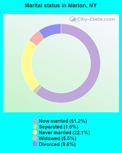
- Never married: 22.1%
- Now married: 61.2%
- Separated: 1.6%
- Widowed: 5.5%
- Divorced: 9.6%
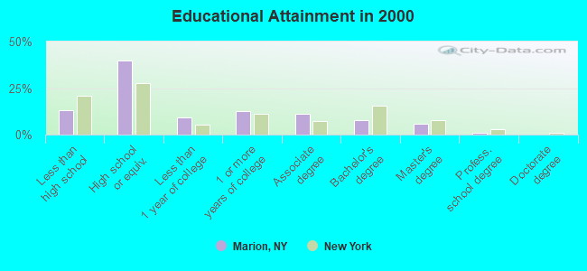
For population 25 years and over in Marion:
- High school or higher: 86.8%
- Bachelor's degree or higher: 14.4%
- Graduate or professional degree: 6.6%
- Unemployed: 4.1%
- Mean travel time to work (commute): 25.8 minutes
| Here: | 10.2 |
| New York average: | 14.2 |
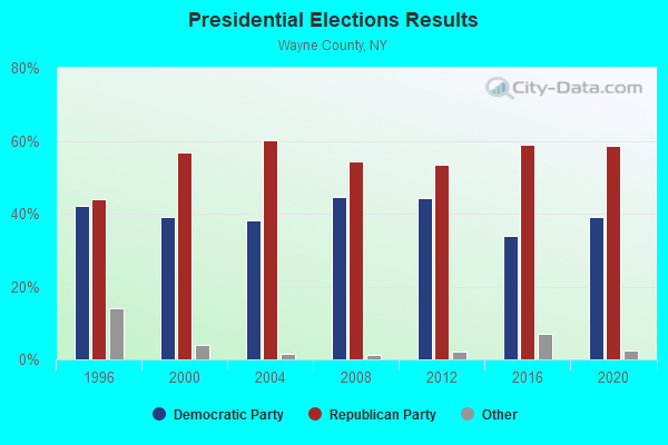
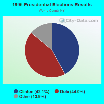
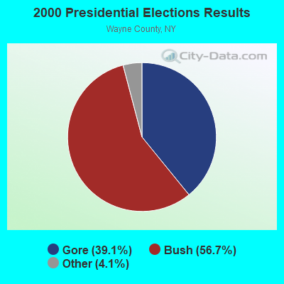
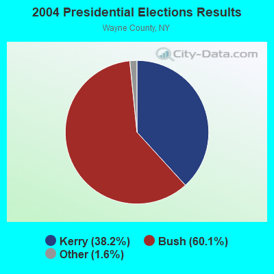
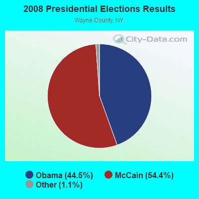
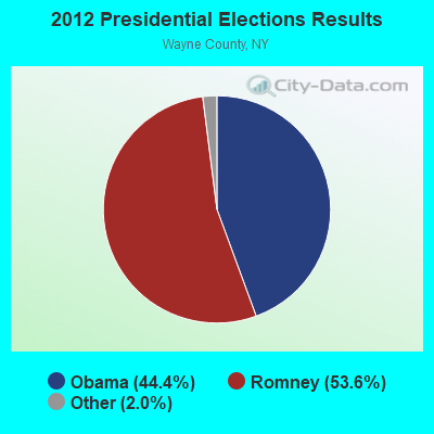
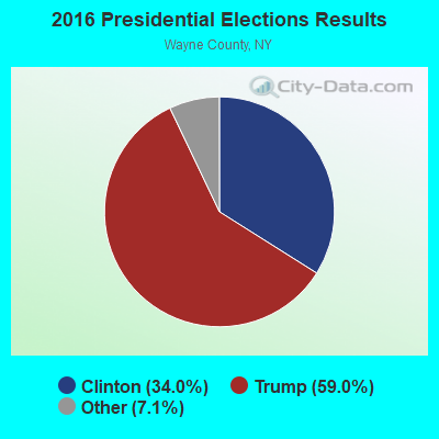
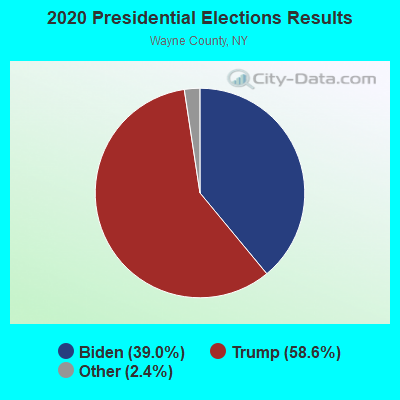
Graphs represent county-level data. Detailed 2008 Election Results
Religion statistics for Marion, NY (based on Wayne County data)
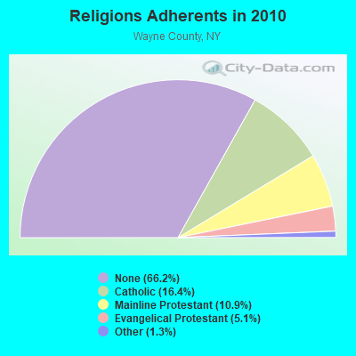
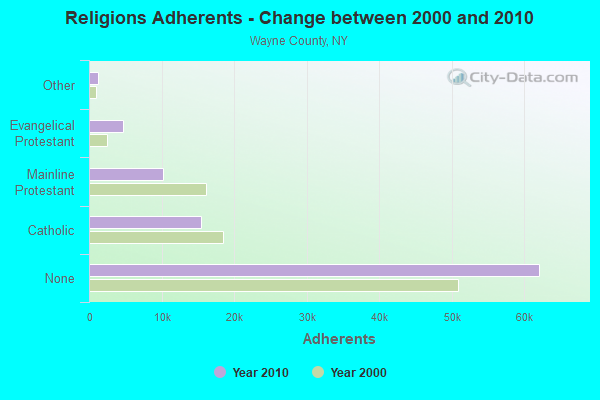
| Religion | Adherents | Congregations |
|---|---|---|
| Catholic | 15,422 | 8 |
| Mainline Protestant | 10,259 | 57 |
| Evangelical Protestant | 4,743 | 44 |
| Other | 1,254 | 5 |
| Black Protestant | - | 2 |
| None | 62,094 | - |
Food Environment Statistics:
| This county: | 1.75 / 10,000 pop. |
| State: | 4.13 / 10,000 pop. |
| Wayne County: | 0.66 / 10,000 pop. |
| New York: | 0.92 / 10,000 pop. |
| This county: | 4.59 / 10,000 pop. |
| New York: | 1.68 / 10,000 pop. |
| Wayne County: | 5.90 / 10,000 pop. |
| New York: | 8.82 / 10,000 pop. |
| Here: | 8.9% |
| New York: | 8.2% |
| Wayne County: | 25.4% |
| New York: | 23.8% |
| Wayne County: | 14.0% |
| New York: | 15.6% |
Strongest AM radio stations in Marion:
- WHAM (1180 AM; 50 kW; ROCHESTER, NY; Owner: CITICASTERS LICENSES, L.P.)
- WACK (1420 AM; 5 kW; NEWARK, NY; Owner: PEMBROOK PINES, INC.)
- WHTK (1280 AM; 5 kW; ROCHESTER, NY)
- WXXI (1370 AM; 5 kW; ROCHESTER, NY; Owner: WXXI PUBLIC BROADCASTING COUNCIL)
- WHIC (1460 AM; 5 kW; ROCHESTER, NY; Owner: HOLY FAMILY COMMUNICATIONS)
- WWKB (1520 AM; 50 kW; BUFFALO, NY; Owner: ENTERCOM BUFFALO LICENSE, LLC)
- WLGZ (990 AM; 5 kW; ROCHESTER, NY; Owner: KIMTRON, INC.)
- WHEN (620 AM; 5 kW; SYRACUSE, NY; Owner: CLEAR CHANNEL BROADCASTING LICENSES, INC.)
- WSYR (570 AM; 5 kW; SYRACUSE, NY; Owner: CLEAR CHANNEL BROADCASTING LICENSES, INC.)
- WROC (950 AM; 1 kW; ROCHESTER, NY)
- WABH (1380 AM; 10 kW; BATH, NY)
- WGY (810 AM; 50 kW; SCHENECTADY, NY; Owner: CLEAR CHANNEL BROADCASTING LICENSES, INC.)
- WYSL (1040 AM; 2 kW; AVON, NY; Owner: RADIO LIVINGSTON, LTD)
Strongest FM radio stations in Marion:
- WFRW (88.1 FM; WEBSTER, NY; Owner: FAMILY STATIONS, INC.)
- WUUF (103.5 FM; SODUS, NY; Owner: WAYNCO RADIO)
- WBEE-FM (92.5 FM; ROCHESTER, NY; Owner: ENTERCOM ROCHESTER LICENSE, LLC.)
- WZXV (99.7 FM; PALMYRA, NY; Owner: CALVARY CHAPEL OF FINGER LAKES, INC.)
- WISY (102.3 FM; CANANDAIGUA, NY; Owner: CITICASTERS LICENSES, L.P.)
- WVOR-FM (100.5 FM; ROCHESTER, NY; Owner: CITICASTERS LICENSES, L.P.)
- WBER (90.5 FM; ROCHESTER, NY; Owner: MONROE B.O.C.E.S. #1)
- WBBF-FM (93.3 FM; FAIRPORT, NY; Owner: ENTERCOM ROCHESTER LICENSE, LLC.)
- WCIY (88.9 FM; CANANDAIGUA, NY; Owner: FAMILY LIFE MINISTRIES, INC.)
- WFXF (107.3 FM; SOUTH BRISTOL TOWNSH, NY; Owner: CITICASTERS LICENSES, L.P.)
- WNVE (95.1 FM; HONEOYE FALLS, NY; Owner: CITICASTERS LICENSES, L.P.)
- WDKX (103.9 FM; ROCHESTER, NY; Owner: MONROE COUNTY BROADCASTING CO., LTD.)
- WCOV-FM (93.7 FM; CLYDE, NY; Owner: FAMILY LIFE MINISTRIES, INC.)
- WRMM-FM (101.3 FM; ROCHESTER, NY; Owner: INFINITY RADIO OPERATIONS INC.)
- WCMF-FM (96.5 FM; ROCHESTER, NY; Owner: INFINITY RADIO OPERATIONS INC.)
- WXXI-FM (91.5 FM; ROCHESTER, NY; Owner: WXXI PUBLIC BROADCASTING COUNCIL)
- WBZA (98.9 FM; ROCHESTER, NY; Owner: ENTERCOM ROCHESTER LICENSE, LLC.)
- W238AB (95.5 FM; ROCHESTER, NY; Owner: CITICASTERS LICENSES, L.P.)
- WZNE (94.1 FM; BRIGHTON, NY; Owner: INFINITY RADIO OPERATIONS INC.)
- WPXY-FM (97.9 FM; ROCHESTER, NY; Owner: INFINITY RADIO OPERATIONS INC.)
TV broadcast stations around Marion:
- WBGT-LP (Channel 40; ROCHESTER, NY; Owner: WBGT, LLC)
- WBXO-LP (Channel 15; ROCHESTER, NY; Owner: METRO TV, INC.)
- WUHF (Channel 31; ROCHESTER, NY; Owner: WUHF LICENSEE, LLC)
- W26BZ (Channel 26; VICTOR, NY; Owner: WBGT, LLC)
- WOKR (Channel 13; ROCHESTER, NY; Owner: CENTRAL NY NEWS, INC.)
- WHEC-TV (Channel 10; ROCHESTER, NY; Owner: WHEC-TV, LLC)
- WROC-TV (Channel 8; ROCHESTER, NY; Owner: NEXSTAR BROADCASTING OF ROCHESTER, LLC)
- WXXI-TV (Channel 21; ROCHESTER, NY; Owner: WXXI PUBLIC BROADCASTING COUNCIL)
- W42CO (Channel 42; ROCHESTER, NY; Owner: TRI-STATE CHRISTIAN TV, INC.)
- National Bridge Inventory (NBI) Statistics
- 1Number of bridges
- 3ft / 0.6mTotal length
- $233,000Total costs
- 3,227Total average daily traffic
- 258Total average daily truck traffic
- 3,247Total future (year 2040) average daily traffic
FCC Registered Cell Phone Towers:
1 (See the full list of FCC Registered Cell Phone Towers in Marion)FCC Registered Antenna Towers:
39 (See the full list of FCC Registered Antenna Towers)FCC Registered Broadcast Land Mobile Towers:
4- Newark Marion Rd 1000 E Of Main St (Lat: 43.143944 Lon: -77.189139), Call Sign: KDR736,
Assigned Frequencies: 46.4400 MHz, Grant Date: 03/15/2012, Expiration Date: 03/17/2022, Cancellation Date: 05/21/2022, Registrant: County Of Wayne, 7336 Route 31, Lyons, NY 14489, Phone: (315) 946-5712, Fax: (315) 946-5661, Email:
- 5392 Franklin Rd (Lat: 43.194778 Lon: -77.175250), Call Sign: KNHH219, Licensee ID: L00729015,
Assigned Frequencies: 152.885 MHz, Grant Date: 09/09/2003, Expiration Date: 09/07/2013, Cancellation Date: 11/09/2013, Registrant: Ron Brugge, 5392 Franklin Rd, Marion, NY 14505
- Lat: 43.139028 Lon: -77.191222, Call Sign: WQGS549,
Assigned Frequencies: 464.337 MHz, Grant Date: 04/05/2007, Expiration Date: 04/05/2017, Cancellation Date: 06/10/2017, Certifier: Peter M Blandino, Registrant: Furman Communications Inc, Savannah, NY 13146, Phone: (315) 365-3700, Fax: (315) 365-2813, Email:
- Lat: 43.139028 Lon: -77.191222, Call Sign: WRBL257,
Assigned Frequencies: 464.337 MHz, Grant Date: 04/17/2018, Expiration Date: 04/17/2028, Certifier: Tom Davenport, Registrant: Mid-State Communications, 185 Clear Road, Oriskany, NY 13424, Phone: (315) 736-3061, Fax: (315) 736-8250, Email:
FCC Registered Microwave Towers:
1- SODUS, 5441 Beam Hill Road (Lat: 43.184972 Lon: -77.123056), Type: Tower, Structure height: 58.5 m, Overall height: 60.7 m, Call Sign: WLV817,
Assigned Frequencies: 10616.2 MHz, 10657.5 MHz, 10795.0 MHz, 6372.67 MHz, Grant Date: 01/25/2011, Expiration Date: 02/01/2021, Cancellation Date: 03/19/2014, Registrant: Verizon Wireless, 1120 Sanctuary Pkwy, #150 Gasa5reg, Alpharetta, GA 30009-7630, Phone: (770) 797-1070, Fax: (770) 797-1036, Email:
FCC Registered Amateur Radio Licenses:
27 (See the full list of FCC Registered Amateur Radio Licenses in Marion)FAA Registered Aircraft:
2- Aircraft: CESSNA 150F (Category: Land, Seats: 2, Weight: Up to 12,499 Pounds, Speed: 90 mph), Engine: CONT MOTOR 0-200 SERIES (100 HP) (Reciprocating)
N-Number: 6687F, N6687F, N-6687F, Serial Number: 15063287, Year manufactured: 1966, Airworthiness Date: 02/28/1966, Certificate Issue Date: 08/20/1981
Registrant (Individual): David M Knight, Po Box 113, Marion, NY 14505 - Aircraft: CESSNA 172B (Category: Land, Seats: 4, Weight: Up to 12,499 Pounds, Speed: 105 mph), Engine: CONT MOTOR 0-300 SER (145 HP) (Reciprocating)
N-Number: 7978X, N7978X, N-7978X, Serial Number: 17248478, Year manufactured: 1961, Certificate Issue Date: 07/19/1972
Registrant (Individual): Thomas M Harter, 4430 Eddy Ridge Road, Marion, NY 14505
Deregistered: Cancel Date: 02/04/2017
2002 - 2018 National Fire Incident Reporting System (NFIRS) incidents
- Fire incident types reported to NFIRS in Marion, NY
- 11448.3%Structure Fires
- 9741.1%Outside Fires
- 229.3%Mobile Property/Vehicle Fires
- 31.3%Other
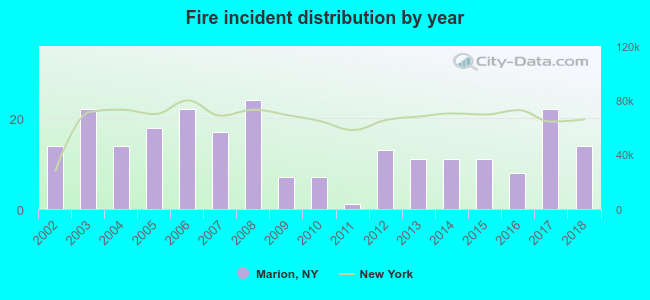 Based on the data from the years 2002 - 2018 the average number of fires per year is 14. The highest number of reported fires - 24 took place in 2008, and the least - 1 in 2011. The data has a constant trend.
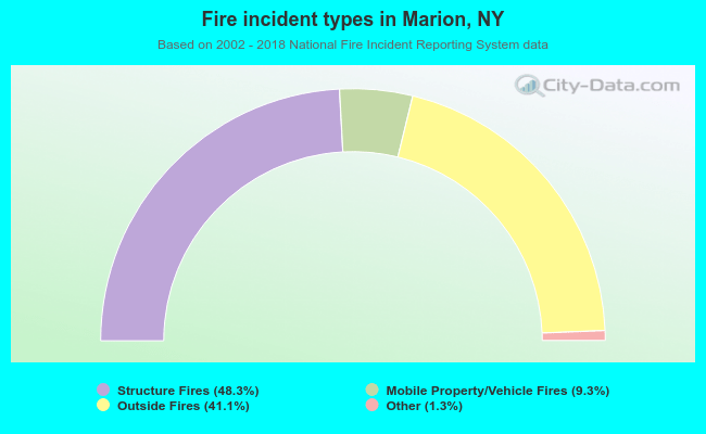 When looking into fire subcategories, the most reports belonged to: Structure Fires (48.3%), and Outside Fires (41.1%).
| Most common first names in Marion, NY among deceased individuals | ||
| Name | Count | Lived (average) |
|---|---|---|
| John | 35 | 76.9 years |
| Mary | 29 | 81.1 years |
| William | 26 | 74.4 years |
| Peter | 22 | 82.8 years |
| Robert | 20 | 74.2 years |
| Margaret | 19 | 82.2 years |
| Jacob | 16 | 78.6 years |
| James | 14 | 71.6 years |
| Anna | 13 | 83.0 years |
| Stanley | 13 | 74.2 years |
| Most common last names in Marion, NY among deceased individuals | ||
| Last name | Count | Lived (average) |
|---|---|---|
| Johnson | 20 | 74.0 years |
| Boerman | 13 | 80.0 years |
| Vanhall | 12 | 82.7 years |
| Smith | 12 | 73.2 years |
| Cook | 11 | 78.8 years |
| Steurrys | 11 | 76.4 years |
| White | 10 | 83.1 years |
| Adriaansen | 8 | 79.6 years |
| Verplank | 8 | 83.4 years |
| Miller | 8 | 74.1 years |
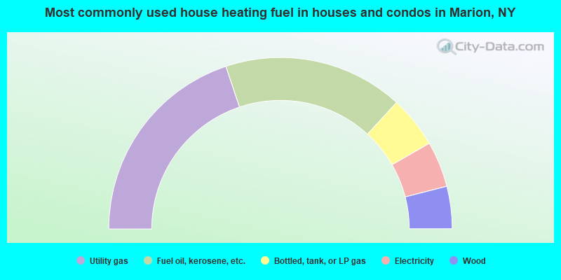
- 39.7%Utility gas
- 33.9%Fuel oil, kerosene, etc.
- 9.8%Bottled, tank, or LP gas
- 8.6%Electricity
- 8.0%Wood
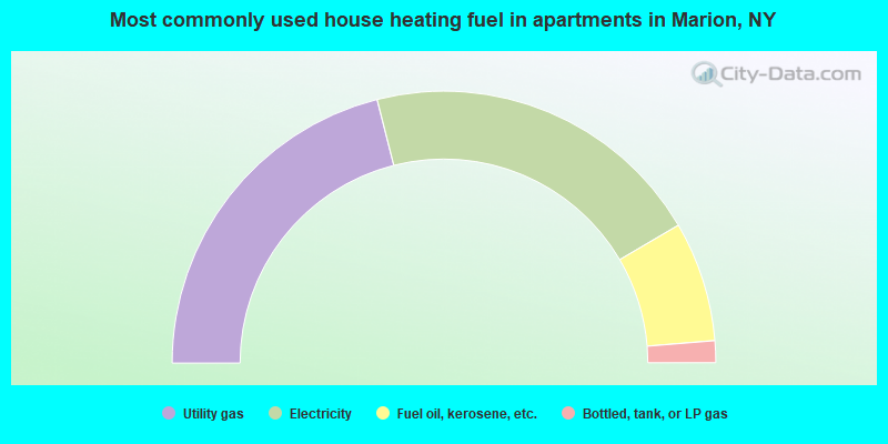
- 42.1%Utility gas
- 41.0%Electricity
- 14.3%Fuel oil, kerosene, etc.
- 2.6%Bottled, tank, or LP gas
Marion compared to New York state average:
- Median house value significantly below state average.
- Unemployed percentage significantly below state average.
- Black race population percentage significantly below state average.
- Hispanic race population percentage significantly below state average.
- Foreign-born population percentage significantly below state average.
- Renting percentage significantly below state average.
- Length of stay since moving in significantly above state average.
- Number of rooms per house significantly below state average.
- House age significantly below state average.
- Percentage of population with a bachelor's degree or higher below state average.

|
|
Total of 150 patent applications in 2008-2024.