Manheim, New York
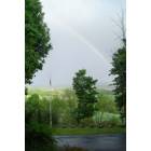
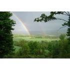
Submit your own pictures of this town and show them to the world
- OSM Map
- Google Map
- MSN Map
Population change since 2000: +5.1%
 |
| Males: 1,637 | |
| Females: 1,697 |
| Median resident age: | 40.3 years |
| New York median age: | 40.7 years |
Zip codes: 13365.
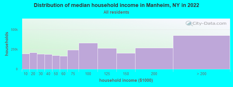
| Manheim: | $64,200 |
| NY: | $79,557 |
Estimated per capita income in 2022: $33,050 (it was $15,429 in 2000)
Manheim town income, earnings, and wages data
Estimated median house or condo value in 2022: $110,464 (it was $52,700 in 2000)
| Manheim: | $110,464 |
| NY: | $400,400 |
Mean prices in 2022: all housing units: $171,805; detached houses: $188,850; townhouses or other attached units: $180,855; in 2-unit structures: $120,765; in 3-to-4-unit structures: $192,443; in 5-or-more-unit structures: $403,258; mobile homes: $63,441
Detailed information about poverty and poor residents in Manheim, NY
Compare current foreclosures near Manheim, NY:
| Photo | Address | Area | Beds / Baths | Price | Details |
|---|---|---|---|---|---|

|
#1
Pine Ave
Herkimer, NY 13350
|
1,014 sq. feet
|
1 baths 3 beds |
$31,500
|
show details |

|
#2
County Highway 29a
Springfield Center, NY 13468
|
- sq. feet
|
2 baths 4 beds |
show details | |

|
#3
State Route 5s
Little Falls, NY 13365
|
984 sq. feet
|
1 baths 3 beds |
show details | |

|
#4
Dolge Ave
Dolgeville, NY 13329
|
1,826 sq. feet
|
1 baths 3 beds |
show details | |

|
#5
John St
Saint Johnsville, NY 13452
|
1,672 sq. feet
|
2 baths 4 beds |
show details | |

|
#6
Bickford Rd
Stratford, NY 13470
|
1,890 sq. feet
|
1 baths 1 beds |
show details | |

|
#7
Hogsback Rd
Richfield Springs, NY 13439
|
1,920 sq. feet
|
1 baths 3 beds |
show details | |

|
#8
Johnycake Rd
Mohawk, NY 13407
|
1,404 sq. feet
|
1 baths 3 beds |
show details | |

|
#9
Bliss Rd
Dolgeville, NY 13329
|
1,323 sq. feet
|
2 baths 3 beds |
show details | |

|
#10
William St # 1
Herkimer, NY 13350
|
2,008 sq. feet
|
2 baths 4 beds |
show details |
| Photo | Address | Area | Beds / Baths | Price | Details |
|---|---|---|---|---|---|

|
#11
Ritter Rd
Little Falls, NY 13365
|
6,400 sq. feet
|
2 baths 4 beds |
show details | |

|
#12
Charles St
Herkimer, NY 13350
|
1,092 sq. feet
|
1 baths 3 beds |
show details | |

|
#13
Michigan St
Mohawk, NY 13407
|
1,800 sq. feet
|
2 baths 4 beds |
show details | |

|
#14
S Richfield St
Mohawk, NY 13407
|
1,564 sq. feet
|
1 baths 3 beds |
show details | |

|
#15
Budnick Rd
Fort Plain, NY 13339
|
1,008 sq. feet
|
1 baths 2 beds |
show details | |

|
#16
2nd St
Ilion, NY 13357
|
3,041 sq. feet
|
2 baths 4 beds |
show details | |

|
#17
Ray St S
Ilion, NY 13357
|
2,224 sq. feet
|
2 baths 4 beds |
show details | |

|
#18
State Route 5
Frankfort, NY 13340
|
1,364 sq. feet
|
1 baths 3 beds |
show details | |

|
#19
Watkins Rd
Frankfort, NY 13340
|
1,080 sq. feet
|
2 baths 3 beds |
show details | |

|
#20
5th Avenue Ext
Frankfort, NY 13340
|
1,320 sq. feet
|
1 baths 3 beds |
show details |
| Photo | Address | Area | Beds / Baths | Price | Details |
|---|---|---|---|---|---|

|
#21
State Route 5
Frankfort, NY 13340
|
1,317 sq. feet
|
1 baths 3 beds |
show details | |

|
#22
State Highway 10
Fort Plain, NY 13339
|
1,848 sq. feet
|
1 baths 3 beds |
show details | |

|
#23
Southside Rd
Frankfort, NY 13340
|
1,652 sq. feet
|
2 baths 3 beds |
show details | |

|
#24
Walnut St
Canajoharie, NY 13317
|
2,079 sq. feet
|
1 baths 3 beds |
show details | |

|
#25
Montgomery St
Canajoharie, NY 13317
|
3,691 sq. feet
|
3 baths 4 beds |
show details | |

|
#26
Orchard St
Canajoharie, NY 13317
|
2,032 sq. feet
|
1 baths 3 beds |
show details | |

|
#27
Us Highway 20
East Springfield, NY 13333
|
1,144 sq. feet
|
2 baths 3 beds |
show details | |

|
#28
Montgomery St
Canajoharie, NY 13317
|
2,172 sq. feet
|
2 baths 3 beds |
show details | |

|
#29
Shells Bush Rd
Herkimer, NY 13350
|
1,840 sq. feet
|
1 baths 3 beds |
show details | |

|
#30
State Route 167
Little Falls, NY 13365
|
1,256 sq. feet
|
1 baths 3 beds |
show details |
| Photo | Address | Area | Beds / Baths | Price | Details |
|---|---|---|---|---|---|

|
#31
Ohara Rd
Little Falls, NY 13365
|
1,496 sq. feet
|
1 baths 3 beds |
show details | |

|
#32
State Highway 29
Dolgeville, NY 13329
|
1,176 sq. feet
|
1 baths 1 beds |
show details | |

|
#33
Howard St
Dolgeville, NY 13329
|
2,155 sq. feet
|
1 baths 3 beds |
show details | |

|
#34
Moreland St
Little Falls, NY 13365
|
1,302 sq. feet
|
1 baths 4 beds |
show details | |

|
#35
Highland Ave
Little Falls, NY 13365
|
1,404 sq. feet
|
1 baths 3 beds |
show details | |

|
#36
Burwell St
Little Falls, NY 13365
|
1,480 sq. feet
|
2 baths 4 beds |
show details | |

|
#37
Creek Rd
Little Falls, NY 13365
|
1,414 sq. feet
|
1 baths 2 beds |
show details | |

|
#38
Skinner St
Little Falls, NY 13365
|
1,670 sq. feet
|
1 baths 4 beds |
show details | |

|
#39
River Rd
Fort Plain, NY 13339
|
3,829 sq. feet
|
2 baths 6 beds |
show details | |

|
#40
Main St
Jordanville, NY 13361
|
- sq. feet
|
- baths - beds |
show details |
| Photo | Address | Area | Beds / Baths | Price | Details |
|---|---|---|---|---|---|

|
#41
W Prospect St
Ilion, NY 13357
|
- sq. feet
|
- baths - beds |
show details | |

|
#42
Rockwell Dr
Ilion, NY 13357
|
- sq. feet
|
- baths - beds |
show details | |

|
#43
Burwell St
Little Falls, NY 13365
|
- sq. feet
|
- baths - beds |
show details | |

|
#44
S Frank St
Frankfort, NY 13340
|
- sq. feet
|
- baths - beds |
show details | |

|
#45
Albany St
Little Falls, NY 13365
|
- sq. feet
|
- baths - beds |
show details | |

|
#46
Johnycake Rd
Mohawk, NY 13407
|
- sq. feet
|
- baths - beds |
show details | |

|
#47
Burnwell St
Little Falls, NY 13365
|
- sq. feet
|
- baths - beds |
show details | |

|
#48
Burnwell St
Little Falls, NY 13365
|
- sq. feet
|
- baths - beds |
show details | |

|
#49
Burwell St
Little Falls, NY 13365
|
- sq. feet
|
- baths - beds |
show details | |

|
Check over 1 million property listings on Foreclosure.com!
|
browse all offers | |||

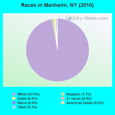
- 3,23497.0%White alone
- 381.1%Hispanic
- 210.6%Asian alone
- 130.4%Black alone
- 150.4%Two or more races
- 80.2%American Indian alone
- 50.1%Other race alone
Races in Manheim detailed stats: ancestries, foreign born residents, place of birth
 Recent articles from our blog. Our writers, many of them Ph.D. graduates or candidates, create easy-to-read articles on a wide variety of topics.
Ancestries: German (27.6%), Irish (15.5%), Italian (12.9%), English (10.4%), Polish (8.6%), French (6.7%).
Current Local Time: EST time zone
Land area: 29.0 square miles.
Population density: 115 people per square mile (very low).
25 residents are foreign born
| This town: | 0.8% |
| New York: | 20.4% |
| Manheim town: | 2.3% ($1,215) |
| New York: | 1.9% ($2,847) |
Nearest city with pop. 50,000+: Utica, NY  (22.1 miles , pop. 60,651).
Nearest city with pop. 200,000+: Rochester, NY (142.3 miles , pop. 219,773).
Nearest city with pop. 1,000,000+: Bronx, NY (160.7 miles , pop. 1,332,650).
Nearest cities:
), ), ), Latitude: 43.07 N, Longitude: 74.80 W
Area code commonly used in this area: 315
Single-family new house construction building permits:
- 2022: 1 building, cost: $100,000
- 2021: 2 buildings, average cost: $50,000
- 2020: 1 building, cost: $100,000
- 2019: 1 building, cost: $80,000
- 2018: 2 buildings, average cost: $75,000
- 2017: 3 buildings, average cost: $83,300
- 2016: 3 buildings, average cost: $666,700
- 2015: 3 buildings, average cost: $666,700
- 2013: 3 buildings, average cost: $50,000
- 2012: 1 building, cost: $100,000
- 2011: 4 buildings, average cost: $50,000
- 2010: 3 buildings, average cost: $50,300
- 2009: 4 buildings, average cost: $75,000
- 2008: 2 buildings, average cost: $50,000
- 2007: 2 buildings, average cost: $181,200
- 2005: 4 buildings, average cost: $100,000
- 2004: 8 buildings, average cost: $153,100
- 2003: 7 buildings, average cost: $153,100
- 2002: 3 buildings, average cost: $33,300
- 2001: 2 buildings, average cost: $15,000
- 2000: 1 building, cost: $375,000
- 1998: 2 buildings, average cost: $117,000
- 1997: 1 building, cost: $111,800
| Here: | 4.9% |
| New York: | 4.4% |
- Health care (14.2%)
- Educational services (10.6%)
- Accommodation & food services (6.3%)
- Metal & metal products (6.2%)
- Agriculture, forestry, fishing & hunting (5.2%)
- Construction (4.6%)
- Public administration (4.5%)
- Metal & metal products (10.0%)
- Construction (8.5%)
- Agriculture, forestry, fishing & hunting (8.0%)
- Public administration (7.6%)
- Health care (6.5%)
- Educational services (5.6%)
- Textile mills & textile products (4.4%)
- Health care (22.5%)
- Educational services (16.0%)
- Accommodation & food services (10.3%)
- Finance & insurance (6.5%)
- Social assistance (3.5%)
- Food & beverage stores (3.5%)
- Textile mills & textile products (3.4%)
- Other production occupations, including supervisors (6.7%)
- Other management occupations, except farmers and farm managers (5.4%)
- Metal workers and plastic workers (4.9%)
- Preschool, kindergarten, elementary, and middle school teachers (4.6%)
- Nursing, psychiatric, and home health aides (3.5%)
- Building and grounds cleaning and maintenance occupations (3.3%)
- Other sales and related occupations, including supervisors (3.3%)
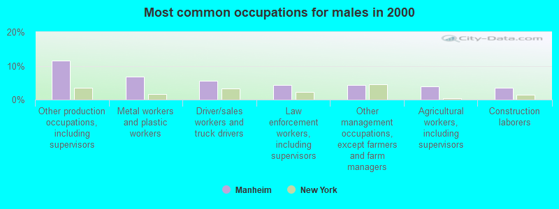
- Other production occupations, including supervisors (11.5%)
- Metal workers and plastic workers (6.9%)
- Driver/sales workers and truck drivers (5.5%)
- Law enforcement workers, including supervisors (4.4%)
- Other management occupations, except farmers and farm managers (4.3%)
- Agricultural workers, including supervisors (3.8%)
- Construction laborers (3.6%)
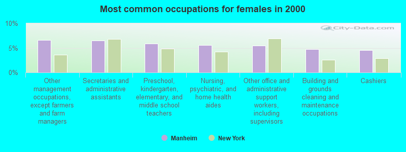
- Other management occupations, except farmers and farm managers (6.6%)
- Secretaries and administrative assistants (6.5%)
- Preschool, kindergarten, elementary, and middle school teachers (5.9%)
- Nursing, psychiatric, and home health aides (5.6%)
- Other office and administrative support workers, including supervisors (5.5%)
- Building and grounds cleaning and maintenance occupations (4.7%)
- Cashiers (4.6%)
Average climate in Manheim, New York
Based on data reported by over 4,000 weather stations


(lower is better)
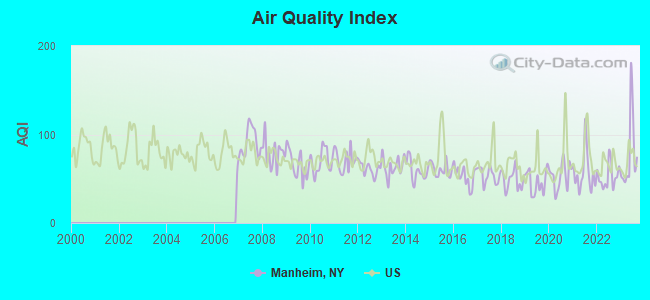
Air Quality Index (AQI) level in 2023 was 77.3. This is about average.
| City: | 77.3 |
| U.S.: | 72.6 |
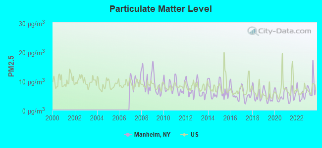
Particulate Matter (PM2.5) [µg/m3] level in 2023 was 7.86. This is about average. Closest monitor was 21.8 miles away from the city center.
| City: | 7.86 |
| U.S.: | 8.11 |
Tornado activity:
Manheim-area historical tornado activity is slightly below New York state average. It is 71% smaller than the overall U.S. average.
On 7/10/1989, a category F4 (max. wind speeds 207-260 mph) tornado 21.1 miles away from the Manheim town center injured 20 people and caused between $5,000,000 and $50,000,000 in damages.
On 5/31/1998, a category F3 (max. wind speeds 158-206 mph) tornado 34.3 miles away from the town center injured 3 people and caused $800,000 in damages.
Earthquake activity:
Manheim-area historical earthquake activity is significantly above New York state average. It is 68% smaller than the overall U.S. average.On 10/7/1983 at 10:18:46, a magnitude 5.3 (5.1 MB, 5.3 LG, 5.1 ML, Class: Moderate, Intensity: VI - VII) earthquake occurred 65.4 miles away from the city center
On 4/20/2002 at 10:50:47, a magnitude 5.3 (5.3 ML, Depth: 3.0 mi) earthquake occurred 114.1 miles away from Manheim center
On 4/20/2002 at 10:50:47, a magnitude 5.2 (5.2 MB, 4.2 MS, 5.2 MW, 5.0 MW) earthquake occurred 112.1 miles away from the city center
On 6/17/1991 at 08:53:16, a magnitude 4.1 (4.0 MB, 4.0 LG, Depth: 3.1 mi, Class: Light, Intensity: IV - V) earthquake occurred 30.7 miles away from Manheim center
On 1/19/1982 at 00:14:42, a magnitude 4.7 (4.5 MB, 4.7 MD, 4.5 LG) earthquake occurred 163.7 miles away from the city center
On 8/23/2011 at 17:51:04, a magnitude 5.8 (5.8 MW, Depth: 3.7 mi) earthquake occurred 393.0 miles away from the city center
Magnitude types: regional Lg-wave magnitude (LG), body-wave magnitude (MB), duration magnitude (MD), local magnitude (ML), surface-wave magnitude (MS), moment magnitude (MW)
Natural disasters:
The number of natural disasters in Herkimer County (23) is greater than the US average (15).Major Disasters (Presidential) Declared: 14
Emergencies Declared: 7
Causes of natural disasters: Storms: 12, Floods: 10, Hurricanes: 3, Snowstorms: 2, Tropical Storms: 2, Winds: 2, Blizzard: 1, Power Outage: 1, Tornado: 1, Winter Storm: 1, Other: 2 (Note: some incidents may be assigned to more than one category).
Hospitals and medical centers near Manheim:
- ALPINE REHABILITATION AND NURSING CENTER (Nursing Home, about 3 miles away; LITTLE FALLS, NY)
- BASSETT HEALTHCARE LITTLE FALLS DIALYSIS (Dialysis Facility, about 4 miles away; LITTLE FALLS, NY)
- LITTLE FALLS HOSPITAL Critical Access Hospitals (about 4 miles away; LITTLE FALLS, NY)
- ST JOHNSVILLE REHAB AND NURSING (Nursing Home, about 8 miles away; SAINT JOHNSVILLE, NY)
- FAXTON ST. LUKE'S HEALTHCARE - HERKIMER (Dialysis Facility, about 10 miles away; HERKIMER, NY)
- FOLTS HOME (Nursing Home, about 10 miles away; HERKIMER, NY)
- HERKIMER CO PUBLIC HLTH CHHA (Home Health Center, about 11 miles away; HERKIMER, NY)
Colleges/universities with over 2000 students nearest to Manheim:
- Herkimer County Community College (about 11 miles; Herkimer, NY; Full-time enrollment: 2,774)
- Mohawk Valley Community College (about 22 miles; Utica, NY; FT enrollment: 5,693)
- Utica College (about 25 miles; Utica, NY; FT enrollment: 2,952)
- Fulton-Montgomery Community College (about 27 miles; Johnstown, NY; FT enrollment: 2,043)
- SUNY College of Agriculture and Technology at Cobleskill (about 32 miles; Cobleskill, NY; FT enrollment: 2,455)
- Colgate University (about 42 miles; Hamilton, NY; FT enrollment: 3,094)
- Morrisville State College (about 43 miles; Morrisville, NY; FT enrollment: 2,823)
Points of interest:
Notable locations in Manheim: Hunter Crossing Farm (A), Garlock Corners (B), Dolgeville Wastewater Treatment Plant (C), Little Falls City Wastewater Treatment Plant (D), Dolgeville - Manheim Public Library (E), Strand Theatre (F), Dolgeville Volunteer Fire Department (G), Niagara-Mohawk Power Corporation Dolgeville Hydro Plant (H). Display/hide their locations on the map
Churches in Manheim include: Yellow Church (A), Kingdom Hall of Jehovahs Witnesses (B), Dolgeville Christian Fellowship (C), Inghams Mills Baptist Church (D), Zion Evangelical Lutheran Church (E), First Universalist Church (F), Saint Joseph's Roman Catholic Church (G). Display/hide their locations on the map
Cemeteries: Upper Cemetery (1), Yellow Church Road Cemetery (2), Dolgeville Cemetery (3), Rural Park Cemetery (4), Fink-Van Valkenburg Cemetery (5), Lower Cemetery (6). Display/hide their locations on the map
Reservoirs: East Canada Lake (A), Kyser Lake (B). Display/hide their locations on the map
Streams, rivers, and creeks: Ransom Creek (A), Crum Creek (B), Spruce Creek (C), Cold Brook (D), Bacon Brook (E), Beaver Creek (F). Display/hide their locations on the map
Park in Manheim: Spofford Square (1). Display/hide its location on the map
| This town: | 2.5 people |
| New York: | 2.6 people |
| This town: | 67.2% |
| Whole state: | 63.5% |
| This town: | 10.4% |
| Whole state: | 6.8% |
Likely homosexual households (counted as self-reported same-sex unmarried-partner households)
- Lesbian couples: 0.2% of all households
- Gay men: 0.1% of all households
| This town: | 12.7% |
| Whole state: | 14.6% |
| This town: | 3.8% |
| Whole state: | 7.4% |
15 people in homes for the mentally retarded in 2000
For population 15 years and over in Manheim:
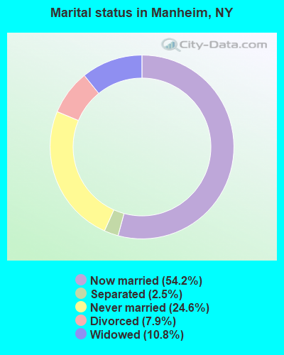
- Never married: 24.6%
- Now married: 54.2%
- Separated: 2.5%
- Widowed: 10.8%
- Divorced: 7.9%
For population 25 years and over in Manheim:
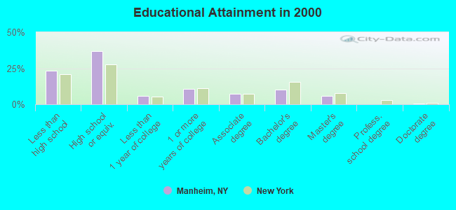
- High school or higher: 76.6%
- Bachelor's degree or higher: 16.2%
- Graduate or professional degree: 6.1%
- Unemployed: 6.0%
- Mean travel time to work (commute): 19.7 minutes
| Here: | 11.5 |
| New York average: | 14.2 |
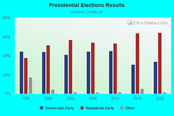
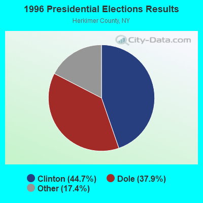
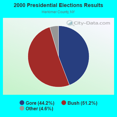
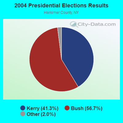
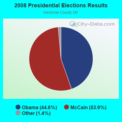
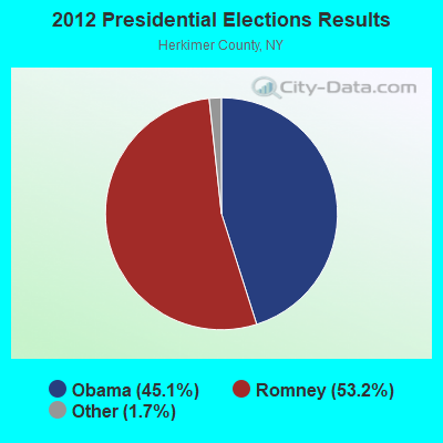
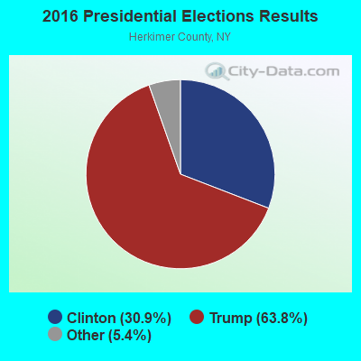
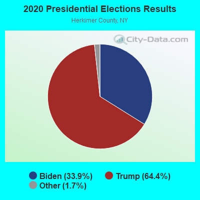
Graphs represent county-level data. Detailed 2008 Election Results
Religion statistics for Manheim, NY (based on Herkimer County data)
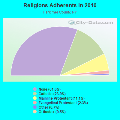
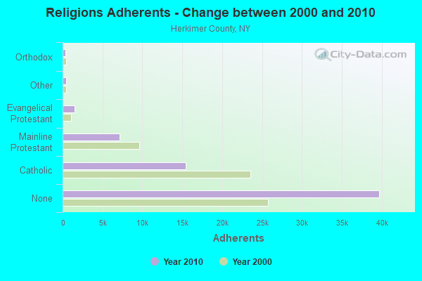
| Religion | Adherents | Congregations |
|---|---|---|
| Catholic | 15,425 | 12 |
| Mainline Protestant | 7,135 | 42 |
| Evangelical Protestant | 1,461 | 22 |
| Other | 450 | 5 |
| Orthodox | 334 | 4 |
| None | 39,714 | - |
Food Environment Statistics:
| This county: | 2.72 / 10,000 pop. |
| New York: | 4.13 / 10,000 pop. |
| This county: | 0.16 / 10,000 pop. |
| New York: | 0.06 / 10,000 pop. |
| Herkimer County: | 0.80 / 10,000 pop. |
| New York: | 0.92 / 10,000 pop. |
| This county: | 3.37 / 10,000 pop. |
| New York: | 1.68 / 10,000 pop. |
| Herkimer County: | 8.82 / 10,000 pop. |
| New York: | 8.82 / 10,000 pop. |
| Herkimer County: | 9.2% |
| New York: | 8.2% |
| Herkimer County: | 24.5% |
| New York: | 23.8% |
| Herkimer County: | 13.7% |
| State: | 15.6% |
Strongest AM radio stations in Manheim:
- WLFH (1230 AM; 1 kW; LITTLE FALLS, NY; Owner: CLEAR CHANNEL BROADCASTING LICENSES, INC.)
- WGY (810 AM; 50 kW; SCHENECTADY, NY; Owner: CLEAR CHANNEL BROADCASTING LICENSES, INC.)
- WPTR (1540 AM; 50 kW; ALBANY, NY; Owner: KIMTRON, INC.)
- WIBX (950 AM; 5 kW; UTICA, NY; Owner: REGENT LICENSEE OF UTICA/ROME, INC.)
- WTLB (1310 AM; 5 kW; UTICA, NY; Owner: GALAXY COMMUNICATIONS, L.P.)
- WRUN (1150 AM; 5 kW; UTICA, NY)
- WNRS (1420 AM; 1 kW; HERKIMER, NY; Owner: ARJUNA BROADCASTING CORP.)
- WNNZ (640 AM; 50 kW; WESTFIELD, MA; Owner: CLEAR CHANNEL BROADCASTING LICENSES, INC.)
- WADR (1480 AM; 5 kW; REMSEN, NY; Owner: CLEAR CHANNEL BROADCASTING LICENSES, INC.)
- WMCA (570 AM; 50 kW; NEW YORK, NY; Owner: SALEM MEDIA OF NEW YORK, LLC)
- WFAN (660 AM; 50 kW; NEW YORK, NY; Owner: INFINITY BROADCASTING OPERATIONS, INC.)
- WABC (770 AM; 50 kW; NEW YORK, NY; Owner: WABC-AM RADIO, INC.)
- WOR (710 AM; 50 kW; NEW YORK, NY; Owner: BUCKLEY BROADCASTING CORPORATION)
Strongest FM radio stations in Manheim:
- WSKU (105.5 FM; LITTLE FALLS, NY; Owner: CLEAR CHANNEL BROADCASTING LICENSES, INC.)
- WBUG-FM (101.1 FM; FORT PLAIN, NY; Owner: ROSER COMMUNICATIONS NETWORK, INC.)
- WBGK (99.7 FM; NEWPORT VILLAGE, NY; Owner: ROSER COMMUNICATIONS NETWORK, INC.)
- W262AC (100.3 FM; LITTLE FALLS, ETC., NY; Owner: FIRST BAPTIST CHURCH)
- WJIV (101.9 FM; CHERRY VALLEY, NY; Owner: CHRISTIAN BROADCASTING SYSTEM, LTD.)
- WOUR (96.9 FM; UTICA, NY; Owner: CLEAR CHANNEL BROADCASTING LICENSES, INC.)
- WUNY (89.5 FM; UTICA, NY; Owner: PUBLIC BC COUNCIL OF CENTRAL NY, INC)
- WLZW (98.7 FM; UTICA, NY; Owner: REGENT LICENSEE OF UTICA/ROME, INC.)
- WQBJ (103.5 FM; COBLESKILL, NY; Owner: REGENT LICENSEE OF MANSFIELD, INC.)
- WXUR (92.7 FM; HERKIMER, NY; Owner: ARJUNA BROADCASTING CORP.)
- WKVU (100.7 FM; UTICA, NY; Owner: EDUCATIONAL MEDIA FOUNDATION)
- WKLL (94.9 FM; FRANKFORT, NY; Owner: GALAXY COMMUNICATIONS, L.P.)
- WXLG (89.9 FM; NORTH CREEK, NY; Owner: THE ST. LAWRENCE UNIVERSITY)
- WRCK (107.3 FM; UTICA, NY; Owner: GALAXY COMMUNICATIONS, L.P.)
- WUCL (93.5 FM; REMSEN, NY; Owner: CLEAR CHANNEL BROADCASTING LICENSES, INC.)
- WGKR (105.3 FM; GRAND GORGE, NY; Owner: SOUND OF LIFE, INC.)
- WCAN (93.3 FM; CANAJOHARIE, NY; Owner: W A M C)
- WSKS (97.9 FM; WHITESBORO, NY; Owner: CLEAR CHANNEL BROADCASTING LICENSES, INC.)
- WBKK (97.7 FM; AMSTERDAM, NY; Owner: GEM ASSOCIATES, L. P.)
- WRBY (102.5 FM; ROME, NY; Owner: CLEAR CHANNEL BROADCASTING LICENSES, INC.)
TV broadcast stations around Manheim:
- WKTV (Channel 2; UTICA, NY; Owner: SMITH TELEVISION OF NEW YORK LICENSE HOLDINGS, INC.)
- W31BP (Channel 31; BURLINGTON, ETC., NY; Owner: QUORUM OF UTICA LICENSE, LLC)
- WFXV (Channel 33; UTICA, NY; Owner: QUORUM OF UTICA LICENSE, LLC)
- WUTR (Channel 20; UTICA, NY; Owner: CENTRAL NY NEWS, INC.)
- WPNY-LP (Channel 11; UTICA, ETC., NY; Owner: QUORUM OF UTICA LICENSE, LLC)
- WYPX (Channel 55; AMSTERDAM, NY; Owner: PAXSON ALBANY LICENSE, INC.)
- W59AU (Channel 59; UTICA, NY; Owner: PUBLIC B/CING.COUNCIL,CENTRAL N. Y.)
- W53AM (Channel 53; UTICA, NY; Owner: QUORUM OF UTICA LICENSE, LLC)
- W04AE (Channel 4; HERKIMER, NY; Owner: YOUNG BROADCASTING OF ALBANY, INC.)
- National Bridge Inventory (NBI) Statistics
- 12Number of bridges
- 79ft / 24.0mTotal length
- $21,745,000Total costs
- 17,002Total average daily traffic
- 1,140Total average daily truck traffic
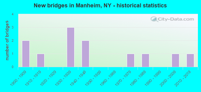
- New bridges - historical statistics
- 21900-1909
- 11910-1919
- 31930-1939
- 21940-1949
- 11970-1979
- 11980-1989
- 12000-2009
- 12010-2019
FCC Registered Antenna Towers: 6 (See the full list of FCC Registered Antenna Towers)
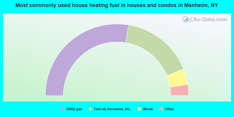
- 55.2%Utility gas
- 32.7%Fuel oil, kerosene, etc.
- 7.1%Wood
- 2.7%Bottled, tank, or LP gas
- 1.9%Electricity
- 0.4%Other fuel
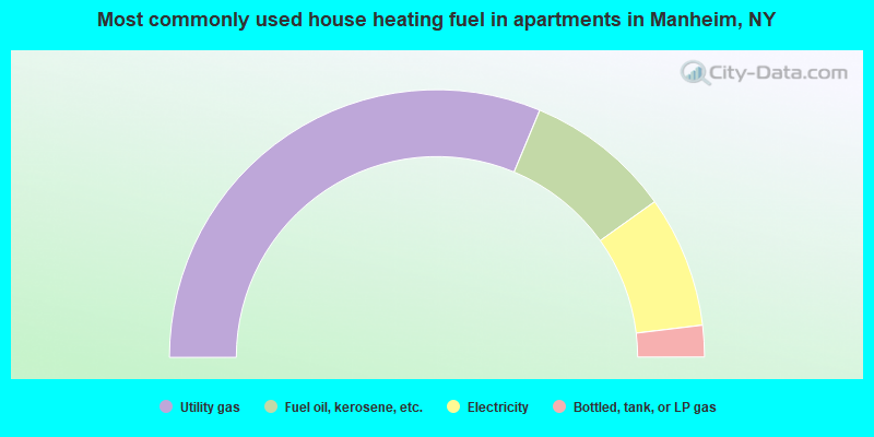
- 62.5%Utility gas
- 17.7%Fuel oil, kerosene, etc.
- 15.9%Electricity
- 3.8%Bottled, tank, or LP gas
Manheim compared to New York state average:
- Median house value significantly below state average.
- Unemployed percentage below state average.
- Black race population percentage significantly below state average.
- Hispanic race population percentage significantly below state average.
- Foreign-born population percentage significantly below state average.
- Renting percentage below state average.
- Length of stay since moving in significantly above state average.
- Number of rooms per house significantly below state average.
- House age significantly below state average.
- Number of college students below state average.
- Percentage of population with a bachelor's degree or higher below state average.