Manchester, Alabama
Submit your own pictures of this place and show them to the world
- OSM Map
- General Map
- Google Map
- MSN Map

| Males: 2,525 | |
| Females: 2,507 |
| Median resident age: | 36.0 years |
| Alabama median age: | 35.8 years |
Zip code: 35503
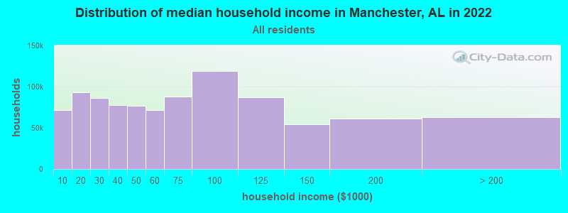
| Manchester: | $58,693 |
| AL: | $59,674 |
Estimated per capita income in 2022: $27,381 (it was $14,899 in 2000)
Manchester CCD income, earnings, and wages data
Estimated median house or condo value in 2022: $149,471 (it was $59,800 in 2000)
| Manchester: | $149,471 |
| AL: | $200,900 |
Detailed information about poverty and poor residents in Manchester, AL


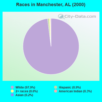
- 5,07197.9%White alone
- 470.9%Hispanic
- 320.6%Two or more races
- 140.3%American Indian alone
- 120.2%Asian alone
- 50.10%Black alone
 Recent articles from our blog. Our writers, many of them Ph.D. graduates or candidates, create easy-to-read articles on a wide variety of topics.
Current Local Time: CST time zone
Land area: 54.9 square miles.
Population density: 92 people per square mile (very low).

| Manchester CCD: | 0.3% ($199) |
| Alabama: | 0.4% ($289) |
Nearest city with pop. 50,000+: Birmingham, AL  (39.9 miles , pop. 242,820).
Nearest city with pop. 1,000,000+: Chicago, IL (546.6 miles , pop. 2,896,016).
Nearest cities:
), ), ), )Latitude: 33.94 N, Longitude: 87.29 W
Area code commonly used in this area: 205

| Here: | 2.7% |
| Alabama: | 2.6% |
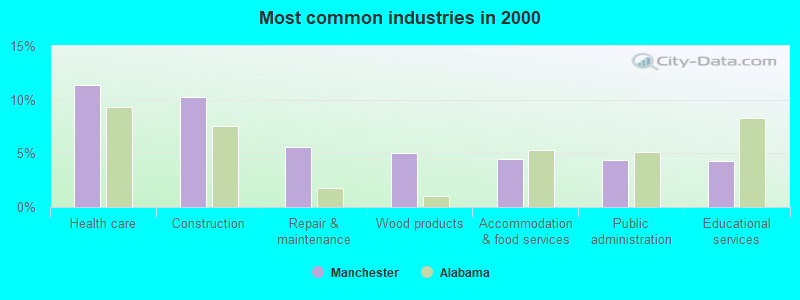
- Health care (11.4%)
- Construction (10.2%)
- Repair & maintenance (5.6%)
- Wood products (5.0%)
- Accommodation & food services (4.5%)
- Public administration (4.4%)
- Educational services (4.3%)
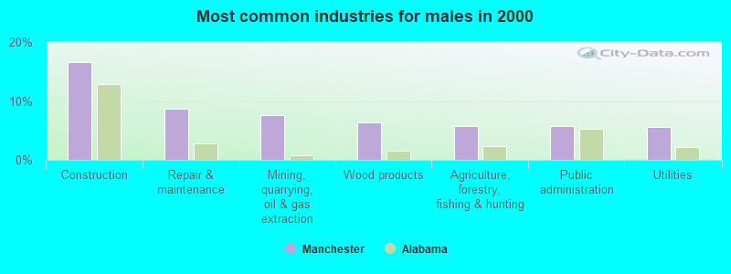
- Construction (16.5%)
- Repair & maintenance (8.7%)
- Mining, quarrying, oil & gas extraction (7.6%)
- Wood products (6.4%)
- Agriculture, forestry, fishing & hunting (5.7%)
- Public administration (5.7%)
- Utilities (5.5%)

- Health care (23.7%)
- Educational services (9.3%)
- Accommodation & food services (6.2%)
- Professional, scientific, technical services (5.2%)
- Department & other general merchandise stores (4.2%)
- Food (4.1%)
- Administrative & support & waste management services (4.1%)
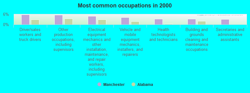
- Driver/sales workers and truck drivers (5.9%)
- Other production occupations, including supervisors (5.7%)
- Electrical equipment mechanics and other installation, maintenance, and repair workers, including supervisors (5.0%)
- Vehicle and mobile equipment mechanics, installers, and repairers (4.2%)
- Health technologists and technicians (3.3%)
- Building and grounds cleaning and maintenance occupations (3.2%)
- Secretaries and administrative assistants (3.1%)
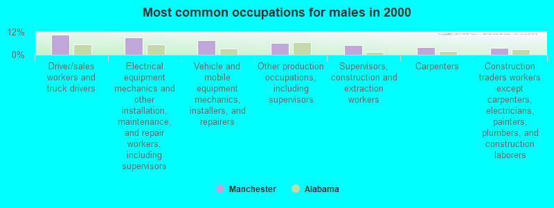
- Driver/sales workers and truck drivers (10.6%)
- Electrical equipment mechanics and other installation, maintenance, and repair workers, including supervisors (9.0%)
- Vehicle and mobile equipment mechanics, installers, and repairers (7.5%)
- Other production occupations, including supervisors (6.3%)
- Supervisors, construction and extraction workers (5.3%)
- Carpenters (3.9%)
- Construction traders workers except carpenters, electricians, painters, plumbers, and construction laborers (3.7%)
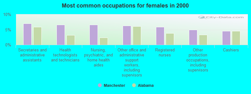
- Secretaries and administrative assistants (7.0%)
- Health technologists and technicians (6.6%)
- Nursing, psychiatric, and home health aides (6.6%)
- Other office and administrative support workers, including supervisors (6.3%)
- Registered nurses (5.8%)
- Other production occupations, including supervisors (4.9%)
- Cashiers (4.5%)
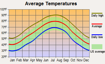
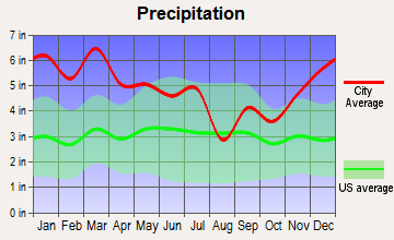
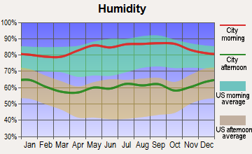
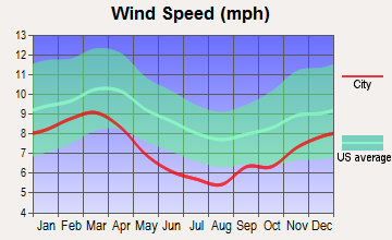
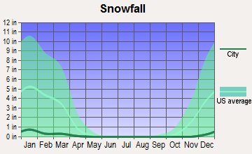
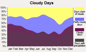
Average climate in Manchester, Alabama
Based on data reported by over 4,000 weather stations

(lower is better)

Air Quality Index (AQI) level in 2022 was 64.4. This is about average.
| City: | 64.4 |
| U.S.: | 72.6 |
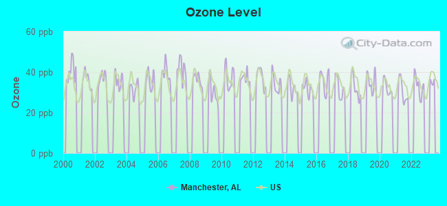
Ozone [ppb] level in 2022 was 33.3. This is about average. Closest monitor was 22.1 miles away from the city center.
| City: | 33.3 |
| U.S.: | 33.3 |
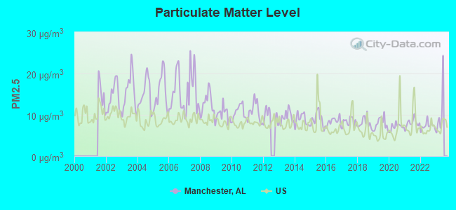
Particulate Matter (PM2.5) [µg/m3] level in 2022 was 7.31. This is about average. Closest monitor was 7.8 miles away from the city center.
| City: | 7.31 |
| U.S.: | 8.11 |
Tornado activity:
Manchester-area historical tornado activity is slightly above Alabama state average. It is 167% greater than the overall U.S. average.
On 11/17/1957, a category F4 (max. wind speeds 207-260 mph) tornado 1.2 miles away from the Manchester place center killed 4 people and injured 15 people and caused between $5000 and $50,000 in damages.
On 4/8/1998, a category F5 (max. wind speeds 261-318 mph) tornado 34.8 miles away from the place center killed 32 people and injured 259 people and caused $200 million in damages.
Earthquake activity:
Manchester-area historical earthquake activity is significantly above Alabama state average. It is 167% greater than the overall U.S. average.On 1/18/1999 at 07:00:53, a magnitude 4.8 (4.8 MB, 4.0 LG, Depth: 0.6 mi, Class: Light, Intensity: IV - V) earthquake occurred 37.4 miles away from the city center
On 4/29/2003 at 08:59:39, a magnitude 4.9 (4.4 MB, 4.6 MW, 4.9 LG) earthquake occurred 102.2 miles away from the city center
On 6/24/1975 at 11:11:36, a magnitude 4.5 (4.5 MB) earthquake occurred 35.4 miles away from Manchester center
On 4/29/2003 at 08:59:39, a magnitude 4.6 (4.6 MW, Depth: 12.3 mi) earthquake occurred 102.1 miles away from the city center
On 3/25/1976 at 00:41:20, a magnitude 5.0 (4.9 MB, 5.0 LG, Class: Moderate, Intensity: VI - VII) earthquake occurred 208.6 miles away from the city center
On 10/24/1997 at 08:35:17, a magnitude 4.9 (4.8 MB, 4.2 MS, 4.9 LG, Depth: 6.2 mi) earthquake occurred 195.2 miles away from Manchester center
Magnitude types: regional Lg-wave magnitude (LG), body-wave magnitude (MB), surface-wave magnitude (MS), moment magnitude (MW)
Natural disasters:
The number of natural disasters in Walker County (21) is greater than the US average (15).Major Disasters (Presidential) Declared: 13
Emergencies Declared: 5
Causes of natural disasters: Storms: 12, Tornadoes: 10, Floods: 9, Winds: 5, Hurricanes: 3, Drought: 1, Fire: 1, Snowfall: 1, Winter Storm: 1, Other: 1 (Note: some incidents may be assigned to more than one category).
Hospitals and medical centers near Manchester:
- KINDRED CARE HOSPICE - JASPER (Hospital, about 7 miles away; JASPER, AL)
- DSI-WALKER COUNTY DIALYSIS (Dialysis Facility, about 7 miles away; JASPER, AL)
- AMEDISYS HOME HEALTH OF WALKER (Home Health Center, about 8 miles away; JASPER, AL)
- WALKER BAPTIST MEDICAL CENTER Acute Care Hospitals (about 8 miles away; JASPER, AL)
- RCG WALKER (Dialysis Facility, about 8 miles away; JASPER, AL)
- MID-SOUTH HOME HEALTH AGENCY INC (Home Health Center, about 9 miles away; JASPER, AL)
- SHADESCREST HEALTH CARE CENTER (Nursing Home, about 9 miles away; JASPER, AL)
Colleges/universities with over 2000 students nearest to Manchester:
- Bevill State Community College (about 8 miles; Jasper, AL; Full-time enrollment: 2,970)
- George C Wallace State Community College-Hanceville (about 31 miles; Hanceville, AL; FT enrollment: 4,486)
- Jefferson State Community College (about 39 miles; Birmingham, AL; FT enrollment: 6,041)
- Lawson State Community College-Birmingham Campus (about 42 miles; Birmingham, AL; FT enrollment: 2,695)
- University of Alabama at Birmingham (about 42 miles; Birmingham, AL; FT enrollment: 14,853)
- Virginia College-Birmingham (about 43 miles; Birmingham, AL; FT enrollment: 8,167)
- Samford University (about 44 miles; Birmingham, AL; FT enrollment: 3,829)
Points of interest:
Notable locations in Manchester: Rose Hill Community Center (A), Curry Volunteer Fire and Rescue (B), Thach Volunteer Fire Department (C), Mount Zion Volunteer Fire and Rescue (D), Mount Zion Fire and Rescue (E). Display/hide their locations on the map
Churches in Manchester include: Union Hill Church (A), New Jerusalem Church (B), New Hope Church (C), I AMS Temple (D), House of Prayer Church (E), Harmony Church (F), Gods Church (G), Glory Hill Church (H), Blackwater Macedonia Church of Christ (I). Display/hide their locations on the map
Cemeteries: Gaddy Cemetery (1), Mount Vernon Cemetery (2), Old Bennett Cemetery (3), Jones Cemetery (4), Bennett Cemetery (5). Display/hide their locations on the map
Streams, rivers, and creeks: Gum Fork (A), Home Creek (B), Pole Branch (C), Rock Creek (D), Spring Creek (E), Strip Pit Creek (F), Teagle Creek (G), Wilson Branch (H), Buck Creek (I). Display/hide their locations on the map
| This place: | 2.6 people |
| Alabama: | 2.5 people |
| This place: | 75.3% |
| Whole state: | 67.8% |
| This place: | 4.4% |
| Whole state: | 4.7% |
Likely homosexual households (counted as self-reported same-sex unmarried-partner households)
- Lesbian couples: 0.3% of all households
- Gay men: 0.3% of all households
| This place: | 16.5% |
| Whole state: | 16.1% |
| This place: | 5.3% |
| Whole state: | 7.3% |
2 people in homes for the mentally retarded in 2000
For population 15 years and over in Manchester:
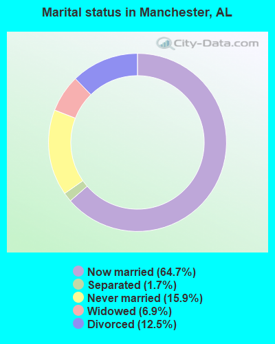
- Never married: 15.9%
- Now married: 64.7%
- Separated: 1.7%
- Widowed: 6.9%
- Divorced: 12.5%
For population 25 years and over in Manchester:
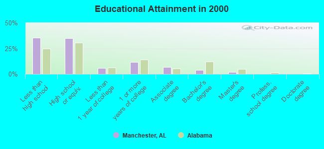
- High school or higher: 64.7%
- Bachelor's degree or higher: 5.8%
- Graduate or professional degree: 2.1%
- Unemployed: 5.4%
- Mean travel time to work (commute): 31.8 minutes
| Here: | 12.7 |
| Alabama average: | 13.2 |
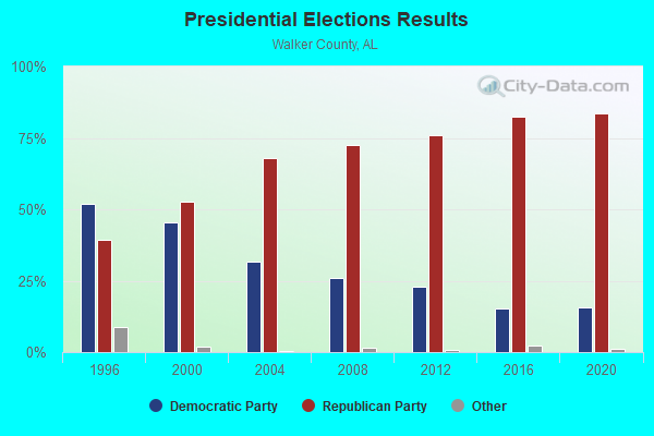
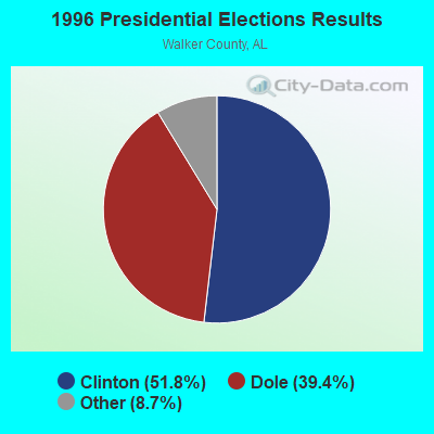
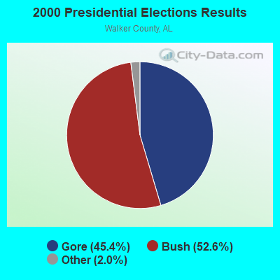
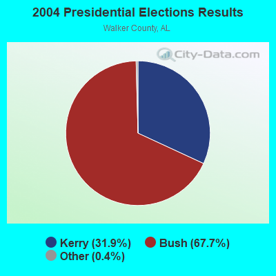

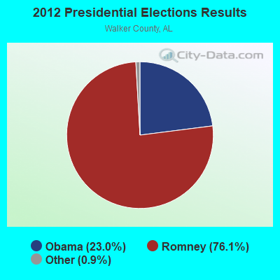
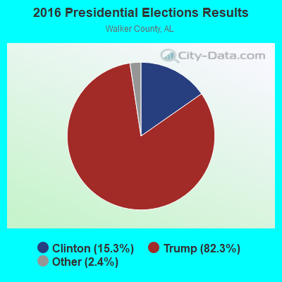
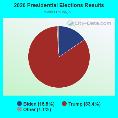
Graphs represent county-level data. Detailed 2008 Election Results
Religion statistics for Manchester, AL (based on Walker County data)
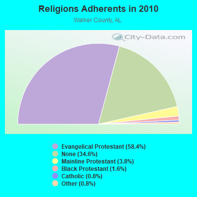
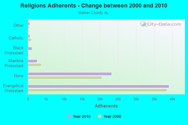
| Religion | Adherents | Congregations |
|---|---|---|
| Evangelical Protestant | 39,118 | 180 |
| Mainline Protestant | 2,552 | 25 |
| Black Protestant | 1,087 | 8 |
| Catholic | 523 | 1 |
| Other | 520 | 3 |
| None | 23,223 | - |
Food Environment Statistics:
| Walker County: | 2.48 / 10,000 pop. |
| State: | 1.89 / 10,000 pop. |
| This county: | 0.29 / 10,000 pop. |
| Alabama: | 0.20 / 10,000 pop. |
| Walker County: | 0.44 / 10,000 pop. |
| State: | 0.65 / 10,000 pop. |
| This county: | 6.41 / 10,000 pop. |
| Alabama: | 6.32 / 10,000 pop. |
| Walker County: | 5.39 / 10,000 pop. |
| Alabama: | 5.75 / 10,000 pop. |
| This county: | 11.9% |
| Alabama: | 11.8% |
| Walker County: | 32.4% |
| Alabama: | 31.7% |
| This county: | 16.5% |
| State: | 13.5% |
Strongest AM radio stations in Manchester:
- WJOX (690 AM; 50 kW; BIRMINGHAM, AL; Owner: CITADEL BROADCASTING COMPANY)
- WDJC (850 AM; 50 kW; BIRMINGHAM, AL; Owner: KIMTRON, INC.)
- WAPI (1070 AM; 50 kW; BIRMINGHAM, AL; Owner: CITADEL BROADCASTING COMPANY)
- WCOC (1010 AM; 5 kW; DORA, AL; Owner: AZTECA COMMUNICATIONS OF ALABAMA, INC.)
- WTID (1240 AM; 1 kW; JASPER, AL; Owner: NEW CENTURY RADIO, INC.)
- WZPQ (1360 AM; 1 kW; JASPER, AL; Owner: JAMES T. LEE)
- WNSI (810 AM; 50 kW; JACKSONVILLE, AL; Owner: UNITED BROADCASTING NETWORK, INC.)
- WLOR (1550 AM; 50 kW; HUNTSVILLE, AL; Owner: BCA RADIO, LLC)
- WCPC (940 AM; 50 kW; HOUSTON, MS; Owner: WCPC BROADCASTING CO., INC.)
- WKXM (1300 AM; 5 kW; WINFIELD, AL; Owner: AD-MEDIA MANAGEMENT CORP.)
- WMCJ (1460 AM; 5 kW; CULLMAN, AL)
- WWAM (820 AM; daytime; 50 kW; JASPER, TN; Owner: SHELTON BROADCASTING SYSTEM)
- WERC (960 AM; 5 kW; BIRMINGHAM, AL; Owner: CAPSTAR TX LIMITED PARTNERSHIP)
Strongest FM radio stations in Manchester:
- WFFN (95.3 FM; CORDOVA, AL; Owner: NEW CENTURY RADIO, INC.)
- WYDE-FM (101.1 FM; CULLMAN, AL; Owner: KIMTRON, INC.)
- WDXB (102.5 FM; JASPER, AL; Owner: CAPSTAR TX LIMITED PARTNERSHIP)
- WRAX (107.7 FM; BIRMINGHAM, AL; Owner: CITADEL BROADCASTING COMPANY)
- WODL (97.3 FM; HOMEWOOD, AL; Owner: CXR HOLDINGS, INC.)
- WBHK (98.7 FM; WARRIOR, AL; Owner: CXR HOLDINGS, INC.)
- WZZK-FM (104.7 FM; BIRMINGHAM, AL; Owner: CXR HOLDINGS, INC.)
- WBPT (106.9 FM; BIRMINGHAM, AL; Owner: CXR HOLDINGS, INC.)
- WQOP-FM (92.5 FM; DORA, AL; Owner: QUEEN OF PEACE RADIO, INC.)
- WYSF (94.5 FM; BIRMINGHAM, AL; Owner: CITADEL BROADCASTING COMPANY)
- WBHM (90.3 FM; BIRMINGHAM, AL; Owner: BD OF TRUSTEES/U OF AL AT BIRMINGHAM)
- WMJJ (96.5 FM; BIRMINGHAM, AL; Owner: CAPSTAR TX LIMITED PARTNERSHIP)
- WQEN (103.7 FM; GADSDEN, AL; Owner: CAPSTAR TX LIMITED PARTNERSHIP)
- WZRR (99.5 FM; BIRMINGHAM, AL; Owner: CITADEL BROADCASTING COMPANY)
- WDJC-FM (93.7 FM; BIRMINGHAM, AL; Owner: KIMTRON, INC.)
TV broadcast stations around Manchester:
- W55BJ (Channel 55; JASPER, AL; Owner: COMBS BROADCASTING, INC.)
- W66CN (Channel 66; JASPER, AL; Owner: TRINITY BROADCASTING NETWORK)
- WDBB (Channel 17; BESSEMER, AL; Owner: WDBB-TV, INC.)
- WCFT-TV (Channel 33; TUSCALOOSA, AL; Owner: TV ALABAMA, INCORPORATED)
- W23AK (Channel 23; JASPER, AL; Owner: WMTY, INC.)
- WIAT (Channel 42; BIRMINGHAM, AL; Owner: MEDIA GENERAL COMMUNICATIONS, INC.)
- WBIQ (Channel 10; BIRMINGHAM, AL; Owner: ALABAMA EDUCATIONAL TELEVISION COMMISSION)
- WABM (Channel 68; BIRMINGHAM, AL; Owner: BIRMINGHAM (WABM-TV) LICENSEE, INC.)
- WTTO (Channel 21; HOMEWOOD, AL; Owner: WTTO LICENSEE, LLC)
- WBRC (Channel 6; BIRMINGHAM, AL; Owner: WBRC LICENSE, INC.)
- WVTM-TV (Channel 13; BIRMINGHAM, AL; Owner: BIRMINGHAM BROADCASTING (WVTM-TV), LLC)
- National Bridge Inventory (NBI) Statistics
- 2Number of bridges
- 56ft / 17.3mTotal length
- $5,345,000Total costs
- 7,153Total average daily traffic
- 406Total average daily truck traffic
- 10,814Total future (year 2030) average daily traffic
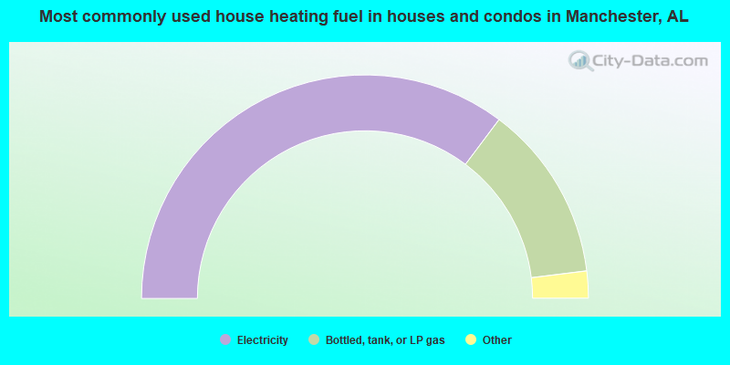
- 70.5%Electricity
- 25.6%Bottled, tank, or LP gas
- 2.1%Wood
- 1.5%Utility gas
- 0.4%No fuel used
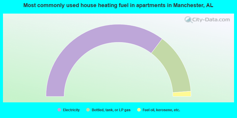
- 70.6%Electricity
- 27.1%Bottled, tank, or LP gas
- 2.3%Fuel oil, kerosene, etc.
Manchester compared to Alabama state average:
- Unemployed percentage below state average.
- Black race population percentage significantly below state average.
- Hispanic race population percentage significantly below state average.
- Median age below state average.
- Foreign-born population percentage significantly below state average.
- Renting percentage below state average.
- Length of stay since moving in significantly above state average.
- Number of rooms per house significantly below state average.
- House age significantly below state average.
- Percentage of population with a bachelor's degree or higher significantly below state average.
Manchester on our top lists:
- #1 on the list of "Top 101 cities with largest percentage of males in industries: metals and minerals, except petroleum, merchant wholesalers (population 5,000+)"
- #3 on the list of "Top 101 cities with largest percentage of males in industries: repair and maintenance (population 5,000+)"
- #9 on the list of "Top 101 cities with largest percentage of males in occupations: supervisors of construction and extraction workers (population 5,000+)"
- #9 on the list of "Top 101 cities with largest percentage of females in industries: wood products (population 5,000+)"
- #15 on the list of "Top 101 cities with largest percentage of females in occupations: painters and paperhangers (population 5,000+)"
- #17 on the list of "Top 101 cities with largest percentage of females in occupations: food processing workers (population 5,000+)"
- #22 on the list of "Top 101 cities with largest percentage of females in occupations: construction laborers (population 5,000+)"
- #22 on the list of "Top 101 cities with largest percentage of females in industries: machinery, equipment, and supplies merchant wholesalers (population 5,000+)"
- #26 on the list of "Top 101 cities with largest percentage of females in industries: food (population 5,000+)"
- #28 on the list of "Top 101 cities with largest percentage of males in occupations: vehicle and mobile equipment mechanics, installers, and repairers (population 5,000+)"
- #29 on the list of "Top 101 cities with largest percentage of males in occupations: driver/sales workers and truck drivers (population 5,000+)"
- #29 on the list of "Top 101 cities with largest percentage of females in industries: repair and maintenance (population 5,000+)"
- #32 on the list of "Top 101 cities with largest percentage of males in industries: wood products (population 5,000+)"
- #36 on the list of "Top 101 cities with largest percentage of females in industries: health care (population 5,000+)"
- #37 on the list of "Top 101 cities with largest percentage of females in industries: private households (population 5,000+)"
- #56 on the list of "Top 101 cities with largest percentage of males in industries: furniture and related product manufacturing (population 5,000+)"
- #66 on the list of "Top 100 least racially diverse cities (pop. 5,000+)"
- #87 on the list of "Top 101 cities with largest percentage of females in industries: metal and metal products (population 5,000+)"
- #90 on the list of "Top 101 cities with largest percentage of females in industries: pharmacies and drug stores (population 5,000+)"
- #3 on the list of "Top 101 counties with the highest number of deaths per 1000 residents 2007-2013 (pop. 50,000+)"
- #8 on the list of "Top 101 counties with the smallest number of children under 18 without health insurance coverage in 2000 (pop. 50,000+)"
- #13 on the list of "Top 101 counties with the smallest number of people without health insurance coverage in 2000 (pop. 50,000+)"
- #32 on the list of "Top 101 counties with highest percentage of residents voting for Romney (Republican) in the 2012 Presidential Election (pop. 50,000+)"
- #38 on the list of "Top 101 counties with the lowest ground withdrawal of fresh water for public supply (pop. 50,000+)"