Lysander, New York
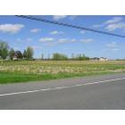
Submit your own pictures of this town and show them to the world
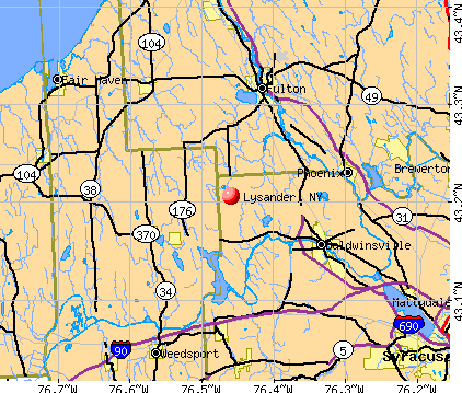
- OSM Map
- General Map
- Google Map
- MSN Map
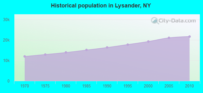
Population change since 2000: +12.8%
 |
| Males: 10,626 | |
| Females: 11,133 |
| Median resident age: | 41.7 years |
| New York median age: | 40.7 years |
Zip codes: 13027.
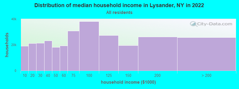
| Lysander: | $102,730 |
| NY: | $79,557 |
Estimated per capita income in 2022: $48,861 (it was $26,187 in 2000)
Lysander town income, earnings, and wages data
Estimated median house or condo value in 2022: $229,754 (it was $107,000 in 2000)
| Lysander: | $229,754 |
| NY: | $400,400 |
Mean prices in 2022: all housing units: $214,284; detached houses: $217,899; townhouses or other attached units: $207,408; in 2-unit structures: $163,770; in 3-to-4-unit structures: $75,948; in 5-or-more-unit structures: $207,108; mobile homes: $52,861
Detailed information about poverty and poor residents in Lysander, NY


- 20,62294.8%White alone
- 3411.6%Hispanic
- 2761.3%Two or more races
- 2481.1%Asian alone
- 1750.8%Black alone
- 770.4%American Indian alone
- 120.06%Other race alone
- 80.04%Native Hawaiian and Other
Pacific Islander alone
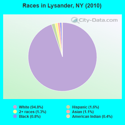
Races in Lysander detailed stats: ancestries, foreign born residents, place of birth
 Recent articles from our blog. Our writers, many of them Ph.D. graduates or candidates, create easy-to-read articles on a wide variety of topics.

 | Ideas for the economic growth and quality of life in Syracuse (333 replies) |
| Syracuse Construction Update (4332 replies) |
| Adding more than 20,000 single family homes in the hills (45 replies) |
| My Onondaga County Comprehensive Plan (42 replies) |
| Syracuse/baldwinsville (13 replies) |
| What's So Great About Syracuse? (15 replies) |
Latest news from Lysander, NY collected exclusively by city-data.com from local newspapers, TV, and radio stations
Ancestries: Irish (23.6%), German (23.1%), English (19.5%), Italian (16.1%), Polish (7.2%), French (5.8%).
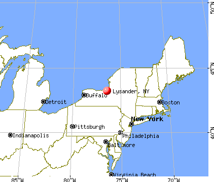
Current Local Time: EST time zone
Elevation: 418 feet
Land area: 61.9 square miles.
Population density: 351 people per square mile (very low).
498 residents are foreign born (0.9% Asia, 0.8% Europe, 0.6% North America).
| This town: | 2.6% |
| New York: | 20.4% |
| Lysander town: | 2.9% ($3,116) |
| New York: | 1.9% ($2,847) |
Nearest city with pop. 50,000+: Clay, NY  (8.3 miles , pop. 58,805).
Nearest city with pop. 200,000+: Rochester, NY (63.4 miles , pop. 219,773).
Nearest city with pop. 1,000,000+: Bronx, NY (205.3 miles , pop. 1,332,650).
Nearest cities:
), ), ), Latitude: 43.17 N, Longitude: 76.35 W
Area code: 315

Lysander, New York accommodation & food services, waste management - Economy and Business Data
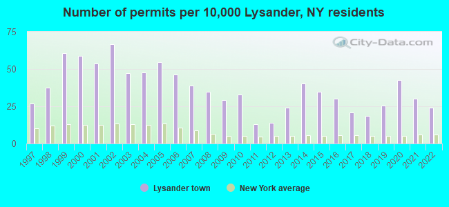
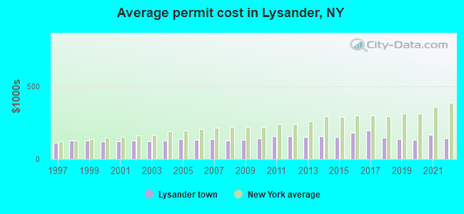
Single-family new house construction building permits:
- 2022: 46 buildings, average cost: $139,500
- 2021: 58 buildings, average cost: $164,100
- 2020: 82 buildings, average cost: $131,300
- 2019: 49 buildings, average cost: $138,100
- 2018: 36 buildings, average cost: $147,500
- 2017: 40 buildings, average cost: $197,300
- 2016: 58 buildings, average cost: $180,000
- 2015: 67 buildings, average cost: $149,400
- 2014: 78 buildings, average cost: $155,600
- 2013: 46 buildings, average cost: $151,000
- 2012: 27 buildings, average cost: $158,400
- 2011: 25 buildings, average cost: $154,000
- 2010: 63 buildings, average cost: $141,600
- 2009: 56 buildings, average cost: $132,600
- 2008: 67 buildings, average cost: $127,900
- 2007: 75 buildings, average cost: $135,100
- 2006: 89 buildings, average cost: $130,400
- 2005: 105 buildings, average cost: $138,800
- 2004: 92 buildings, average cost: $127,200
- 2003: 91 buildings, average cost: $120,000
- 2002: 129 buildings, average cost: $124,900
- 2001: 104 buildings, average cost: $121,800
- 2000: 113 buildings, average cost: $123,000
- 1999: 117 buildings, average cost: $124,700
- 1998: 72 buildings, average cost: $125,400
- 1997: 52 buildings, average cost: $110,900
| Here: | 3.9% |
| New York: | 4.4% |
- Educational services (11.2%)
- Health care (9.0%)
- Professional, scientific, technical services (6.2%)
- Finance & insurance (5.9%)
- Construction (5.0%)
- Accommodation & food services (4.0%)
- Public administration (4.0%)
- Construction (7.9%)
- Professional, scientific, technical services (6.5%)
- Educational services (5.9%)
- Utilities (5.9%)
- Health care (5.0%)
- Finance & insurance (4.5%)
- Public administration (4.3%)
- Educational services (17.1%)
- Health care (13.7%)
- Finance & insurance (7.4%)
- Professional, scientific, technical services (5.8%)
- Accommodation & food services (4.8%)
- Social assistance (4.1%)
- Public administration (3.7%)
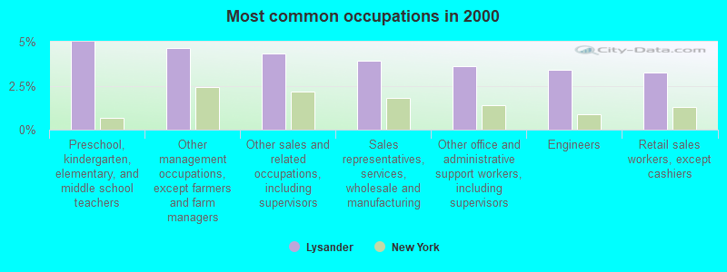
- Preschool, kindergarten, elementary, and middle school teachers (5.0%)
- Other management occupations, except farmers and farm managers (4.6%)
- Other sales and related occupations, including supervisors (4.3%)
- Sales representatives, services, wholesale and manufacturing (3.9%)
- Other office and administrative support workers, including supervisors (3.6%)
- Engineers (3.4%)
- Retail sales workers, except cashiers (3.3%)
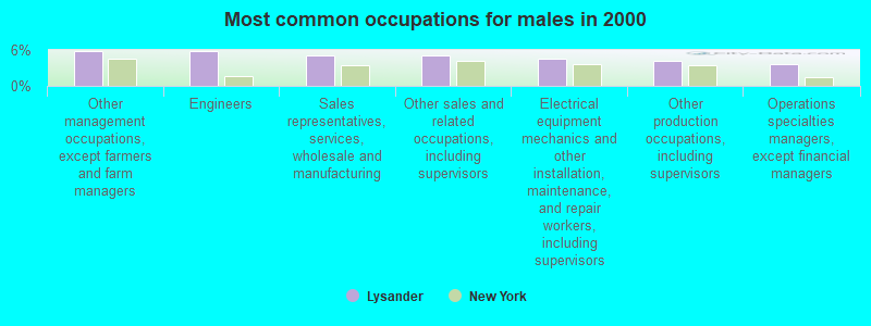
- Other management occupations, except farmers and farm managers (5.8%)
- Engineers (5.8%)
- Sales representatives, services, wholesale and manufacturing (5.1%)
- Other sales and related occupations, including supervisors (5.1%)
- Electrical equipment mechanics and other installation, maintenance, and repair workers, including supervisors (4.5%)
- Other production occupations, including supervisors (4.2%)
- Operations specialties managers, except financial managers (3.6%)
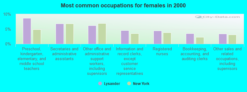
- Preschool, kindergarten, elementary, and middle school teachers (8.6%)
- Secretaries and administrative assistants (6.8%)
- Other office and administrative support workers, including supervisors (6.1%)
- Information and record clerks, except customer service representatives (4.6%)
- Registered nurses (4.5%)
- Bookkeeping, accounting, and auditing clerks (3.5%)
- Other sales and related occupations, including supervisors (3.4%)
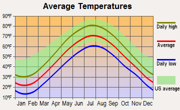
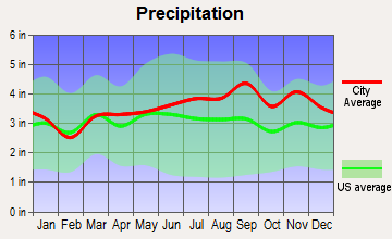
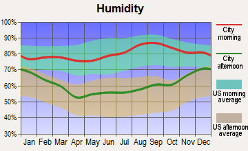
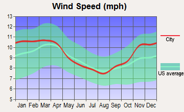
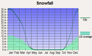
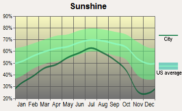
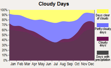
Average climate in Lysander, New York
Based on data reported by over 4,000 weather stations
(lower is better)
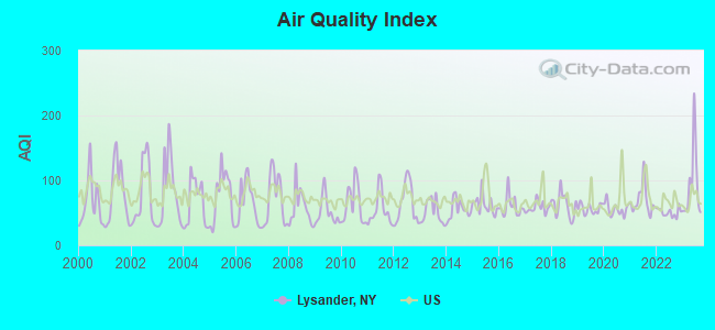
Air Quality Index (AQI) level in 2023 was 92.7. This is worse than average.
| City: | 92.7 |
| U.S.: | 72.6 |
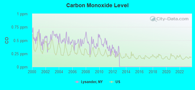
Carbon Monoxide (CO) [ppm] level in 2012 was 0.295. This is about average. Closest monitor was 11.7 miles away from the city center.
| City: | 0.295 |
| U.S.: | 0.251 |
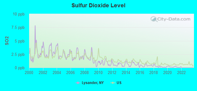
Sulfur Dioxide (SO2) [ppb] level in 2021 was 0.128. This is significantly better than average. Closest monitor was 10.7 miles away from the city center.
| City: | 0.128 |
| U.S.: | 1.515 |
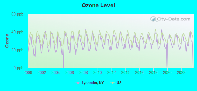
Ozone [ppb] level in 2023 was 31.1. This is about average. Closest monitor was 9.4 miles away from the city center.
| City: | 31.1 |
| U.S.: | 33.3 |
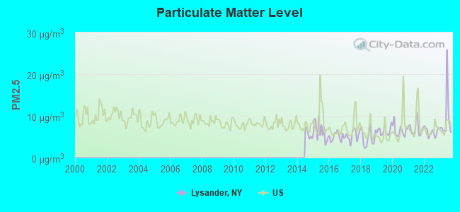
Particulate Matter (PM2.5) [µg/m3] level in 2023 was 9.42. This is about average. Closest monitor was 12.9 miles away from the city center.
| City: | 9.42 |
| U.S.: | 8.11 |
Tornado activity:
Lysander-area historical tornado activity is below New York state average. It is 79% smaller than the overall U.S. average.
On 5/2/1983, a category F3 (max. wind speeds 158-206 mph) tornado 4.8 miles away from the Lysander town center caused between $50,000 and $500,000 in damages.
On 5/2/1983, a category F3 tornado 9.5 miles away from the town center killed one person and caused between $500,000 and $5,000,000 in damages.
Earthquake activity:
Lysander-area historical earthquake activity is significantly above New York state average. It is 68% smaller than the overall U.S. average.On 10/7/1983 at 10:18:46, a magnitude 5.3 (5.1 MB, 5.3 LG, 5.1 ML, Class: Moderate, Intensity: VI - VII) earthquake occurred 114.4 miles away from Lysander center
On 4/20/2002 at 10:50:47, a magnitude 5.3 (5.3 ML, Depth: 3.0 mi) earthquake occurred 161.7 miles away from Lysander center
On 4/20/2002 at 10:50:47, a magnitude 5.2 (5.2 MB, 4.2 MS, 5.2 MW, 5.0 MW) earthquake occurred 159.9 miles away from the city center
On 9/25/1998 at 19:52:52, a magnitude 5.2 (4.8 MB, 4.3 MS, 5.2 LG, 4.5 MW, Depth: 3.1 mi) earthquake occurred 237.1 miles away from Lysander center
On 8/23/2011 at 17:51:04, a magnitude 5.8 (5.8 MW, Depth: 3.7 mi) earthquake occurred 373.4 miles away from Lysander center
On 6/17/1991 at 08:53:16, a magnitude 4.1 (4.0 MB, 4.0 LG, Depth: 3.1 mi, Class: Light, Intensity: IV - V) earthquake occurred 92.9 miles away from Lysander center
Magnitude types: regional Lg-wave magnitude (LG), body-wave magnitude (MB), local magnitude (ML), surface-wave magnitude (MS), moment magnitude (MW)
Natural disasters:
The number of natural disasters in Onondaga County (15) is near the US average (15).Major Disasters (Presidential) Declared: 10
Emergencies Declared: 5
Causes of natural disasters: Storms: 7, Floods: 5, Hurricanes: 2, Blizzard: 1, Heavy Rain: 1, Ice Storm: 1, Landslide: 1, Power Outage: 1, Tornado: 1, Tropical Storm: 1, Wind: 1, Other: 2 (Note: some incidents may be assigned to more than one category).
Hospitals and medical centers near Lysander:
- SYRACUSE HOME ASSOCIATION (Nursing Home, about 2 miles away; BALDWINSVILLE, NY)
- ST. JOSEPH'S - SENECA (Dialysis Facility, about 6 miles away; LIVERPOOL, NY)
- TOOMEY RESIDENTIAL COMMUNITY SERVICES (Hospital, about 9 miles away; LIVERPOOL, NY)
- ELDERWOOD HEALTH CARE AT BIRCHWOOD (Nursing Home, about 10 miles away; LIVERPOOL, NY)
- ST JOSEPHS HOSP HEALTH CENTER CHHA (Home Health Center, about 11 miles away; LIVERPOOL, NY)
- MICHAUD RESIDENTIAL HEALTH SERVICES INC (Nursing Home, about 11 miles away; FULTON, NY)
- ST. JOSEPH'S - CAMILLUS (Dialysis Facility, about 11 miles away; CAMILLUS, NY)
Amtrak station near Lysander:
- 12 miles: SYRACUSE (131 P & C PKWY.) . Services: ticket office, fully wheelchair accessible, enclosed waiting area, public restrooms, public payphones, full-service food facilities, free short-term parking, paid long-term parking, call for car rental service, taxi stand, intercity bus service, public transit connection.
Colleges/universities with over 2000 students nearest to Lysander:
- Onondaga Community College (about 14 miles; Syracuse, NY; Full-time enrollment: 8,920)
- Syracuse University (about 15 miles; Syracuse, NY; FT enrollment: 20,717)
- SUNY College of Environmental Science and Forestry (about 15 miles; Syracuse, NY; FT enrollment: 2,044)
- Le Moyne College (about 17 miles; Syracuse, NY; FT enrollment: 3,041)
- Cayuga County Community College (about 19 miles; Auburn, NY; FT enrollment: 3,141)
- SUNY College at Oswego (about 22 miles; Oswego, NY; FT enrollment: 7,550)
- Hobart William Smith Colleges (about 39 miles; Geneva, NY; FT enrollment: 2,476)
Points of interest:
Notable locations in Lysander: Destiny Farms (A), Radisson Corporate Park (B), North Side Sewage Disposal Plant (C), Brook (D), Abbott Farms (E), Hahn Family Farm (F), Palace Variety Theatre (G), Baldwinsville Village Hall (H), Baldwinsville Public Library (I), Lysander Town Hall (J), Seneca River Fire Department (K), Lysander Fire Department (L), Plainville Fire District Company 2 (M), Plainville Fire District Company 3 (N), Baldwinsville Fire Department Station 3 (O), Plainville Fire District Station 1 (P), Belgium Cold Springs Fire Department (Q). Display/hide their locations on the map
Churches in Lysander include: Saint Mark's Lutheran Church (A), Grace Church (B), Cold Springs Church (C), Little Utica Methodist Church (D), Lamson Road Community Church (E), First Presbyterian Church (F), First United Methodist Church (G), Christian Reformed Church (H). Display/hide their locations on the map
Cemeteries: Plainville Cemetery (1), Hortontown Cemetery (2), Jacksonville Cemetery (3), Old Presbyterian Cemetery (4), Lysander Cemetery (5), Cold Spring Cemetery (6), Belgium Cemetery (7). Display/hide their locations on the map
Lakes and swamps: Mud Lake (A), Frog Hole Swamp (B). Display/hide their locations on the map
Streams, rivers, and creeks: Mud Lake Inlet (A). Display/hide its location on the map
Park in Lysander: Three Rivers State Wildlife Management Area (1). Display/hide its location on the map
| This town: | 2.6 people |
| New York: | 2.6 people |
| This town: | 73.0% |
| Whole state: | 63.5% |
| This town: | 6.4% |
| Whole state: | 6.8% |
Likely homosexual households (counted as self-reported same-sex unmarried-partner households)
- Lesbian couples: 0.4% of all households
- Gay men: 0.2% of all households
| This town: | 3.8% |
| Whole state: | 14.6% |
| This town: | 1.6% |
| Whole state: | 7.4% |
5 people in group homes for juveniles (non-correctional) in 2010
People in group quarters in Lysander in 2000:
- 16 people in homes for the mentally retarded
- 5 people in other group homes
- 4 people in other nonhousehold living situations
For population 15 years and over in Lysander:
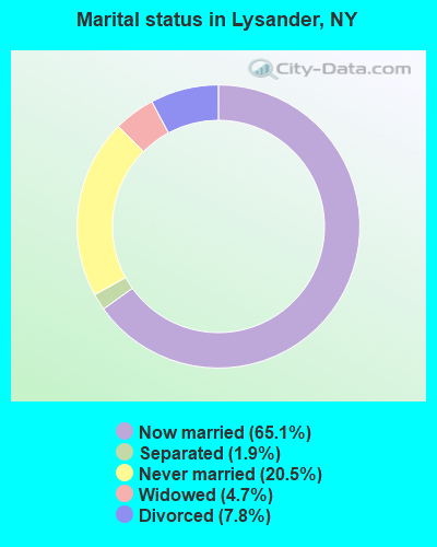
- Never married: 20.5%
- Now married: 65.1%
- Separated: 1.9%
- Widowed: 4.7%
- Divorced: 7.8%
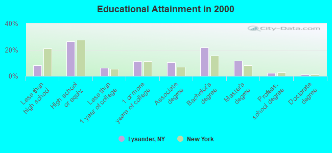
For population 25 years and over in Lysander:
- High school or higher: 91.8%
- Bachelor's degree or higher: 37.0%
- Graduate or professional degree: 15.4%
- Unemployed: 3.2%
- Mean travel time to work (commute): 23.1 minutes
| Here: | 10.2 |
| New York average: | 14.2 |
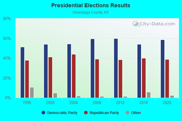
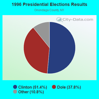
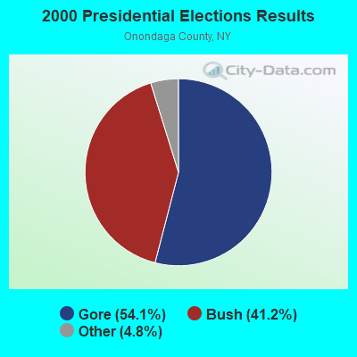
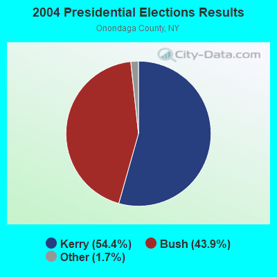
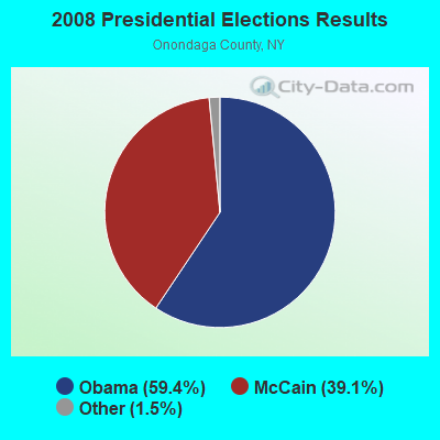

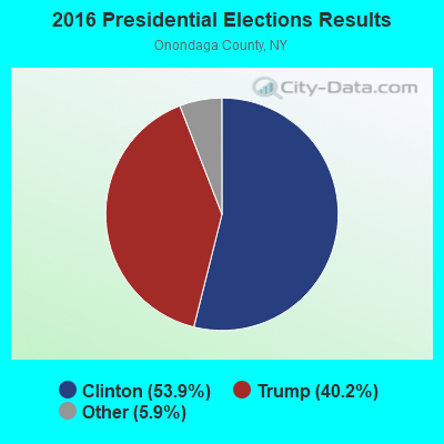
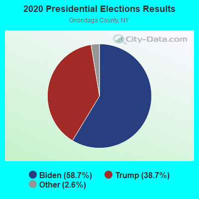
Graphs represent county-level data. Detailed 2008 Election Results
Religion statistics for Lysander, NY (based on Onondaga County data)
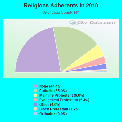
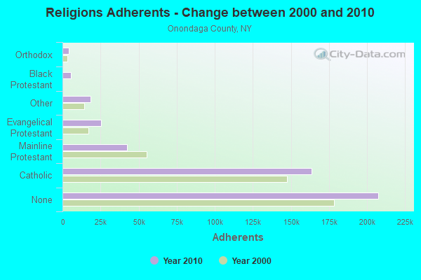
| Religion | Adherents | Congregations |
|---|---|---|
| Catholic | 163,488 | 59 |
| Mainline Protestant | 42,255 | 129 |
| Evangelical Protestant | 25,349 | 137 |
| Other | 18,569 | 34 |
| Black Protestant | 5,690 | 28 |
| Orthodox | 4,152 | 12 |
| None | 207,523 | - |
Food Environment Statistics:
| This county: | 2.56 / 10,000 pop. |
| State: | 4.13 / 10,000 pop. |
| Onondaga County: | 0.11 / 10,000 pop. |
| New York: | 0.06 / 10,000 pop. |
| Onondaga County: | 1.08 / 10,000 pop. |
| New York: | 0.92 / 10,000 pop. |
| This county: | 2.74 / 10,000 pop. |
| New York: | 1.68 / 10,000 pop. |
| This county: | 8.17 / 10,000 pop. |
| New York: | 8.82 / 10,000 pop. |
| Onondaga County: | 7.9% |
| New York: | 8.2% |
| Onondaga County: | 27.3% |
| State: | 23.8% |
| This county: | 13.7% |
| New York: | 15.6% |
4.05% of this county's 2021 resident taxpayers lived in other counties in 2020 ($62,522 average adjusted gross income)
| Here: | 4.05% |
| New York average: | 5.29% |
0.01% of residents moved from foreign countries ($88 average AGI)
Onondaga County: 0.01% New York average: 0.01%
Top counties from which taxpayers relocated into this county between 2020 and 2021:
| from Oswego County, NY | |
| from Madison County, NY | |
| from Cayuga County, NY |
4.93% of this county's 2020 resident taxpayers moved to other counties in 2021 ($66,970 average adjusted gross income)
| Here: | 4.93% |
| New York average: | 6.93% |
0.01% of residents moved to foreign countries ($98 average AGI)
Onondaga County: 0.01% New York average: 0.02%
Top counties to which taxpayers relocated from this county between 2020 and 2021:
| to Oswego County, NY | |
| to Madison County, NY | |
| to Cayuga County, NY |
Strongest AM radio stations in Lysander:
- WFBL (1050 AM; 2 kW; BALDWINSVILLE, NY; Owner: BUCKLEY BROADCASTING CORPORATION)
- WHEN (620 AM; 5 kW; SYRACUSE, NY; Owner: CLEAR CHANNEL BROADCASTING LICENSES, INC.)
- WDCW (1390 AM; 5 kW; SYRACUSE, NY; Owner: KIMTRON, INC.)
- WSYR (570 AM; 5 kW; SYRACUSE, NY; Owner: CLEAR CHANNEL BROADCASTING LICENSES, INC.)
- WNSS (1260 AM; 5 kW; SYRACUSE, NY; Owner: CITADEL BROADCASTING COMPANY)
- WHAM (1180 AM; 50 kW; ROCHESTER, NY; Owner: CITICASTERS LICENSES, L.P.)
- WAMF (1300 AM; 1 kW; FULTON, NY; Owner: DONALD H. DEROSA)
- WTLA (1200 AM; 1 kW; NORTH SYRACUSE, NY; Owner: GALAXY COMMUNICATIONS, L.P.)
- WOLF (1490 AM; 1 kW; SYRACUSE, NY; Owner: WOLF RADIO INC.)
- WGY (810 AM; 50 kW; SCHENECTADY, NY; Owner: CLEAR CHANNEL BROADCASTING LICENSES, INC.)
- WSIV (1540 AM; 2 kW; E. SYRACUSE, NY; Owner: CRAM COMMUNICATIONS LLC)
- WACK (1420 AM; 5 kW; NEWARK, NY; Owner: PEMBROOK PINES, INC.)
- WHCU (870 AM; 5 kW; ITHACA, NY; Owner: EAGLE BROADCASTING COMPANY, INC.)
Strongest FM radio stations in Lysander:
- WSEN-FM (92.1 FM; BALDWINSVILLE, NY; Owner: BUCKLEY BROADCASTING CORPORATION)
- WBBS (104.7 FM; FULTON, NY; Owner: CITICASTERS LICENSES, L.P.)
- WBXL (90.5 FM; BALDWINSVILLE, NY; Owner: BALDWINSVILLE CENTRAL SCHOOL DIST.)
- WZUN (102.1 FM; PHOENIX, NY; Owner: GALAXY COMMUNICATIONS, L.P.)
- WMHR (102.9 FM; SYRACUSE, NY; Owner: MARS HILL BROADCASTING CO., INC.)
- W207BH (89.3 FM; BALDWINSVILLE, NY; Owner: FAMILY LIFE MINISTRIES, INC.)
- WYYY (94.5 FM; SYRACUSE, NY; Owner: CLEAR CHANNEL BROADCASTING LICENSES, INC.)
- WLTI (105.9 FM; SYRACUSE, NY; Owner: CITADEL BROADCASTING COMPANY)
- WCNY-FM (91.3 FM; SYRACUSE, NY; Owner: THE PUB. B/C COUNC. OF CEN. NY, INC.)
- WNTQ (93.1 FM; SYRACUSE, NY; Owner: CITADEL BROADCASTING COMPANY)
- WPHR (106.9 FM; AUBURN, NY; Owner: CLEAR CHANNEL BROADCASTING LICENSES, INC.)
- WKRL-FM (100.9 FM; NORTH SYRACUSE, NY; Owner: GALAXY COMMUNICATIONS, L.P.)
- W278AH (103.5 FM; SYRACUSE, JAMESVILLE, NY; Owner: CALVARY CHAPEL OF THE FINGER LAKES, INC.)
- WWHT (107.9 FM; SYRACUSE, NY; Owner: CLEAR CHANNEL BROADCASTING LICENSES, INC.)
- WAQX-FM (95.7 FM; MANLIUS, NY; Owner: CITADEL BROADCASTING COMPANY)
- WTKV (105.5 FM; OSWEGO, NY; Owner: GALAXY COMMUNICATIONS, L.P.)
- W251AK (98.1 FM; NEDROW, NY; Owner: PATHWAY COMMUNITY RADIO, INC.)
- WRVO (89.9 FM; OSWEGO, NY; Owner: STATE UNIVERSITY OF NEW YORK)
- WAER (88.3 FM; SYRACUSE, NY; Owner: SYRACUSE UNIVERSITY)
- W256AC (99.1 FM; SOLVAY, NY; Owner: GALAXY COMMUNICATIONS, L.P.)
TV broadcast stations around Lysander:
- WSPX-TV (Channel 56; SYRACUSE, NY; Owner: PAXSON SYRACUSE LICENSE, INC.)
- WCNY-TV (Channel 24; SYRACUSE, NY; Owner: PUBLIC BROADCASTING COUNCIL OF CENTRAL NEW YORK)
- WNYS-TV (Channel 43; SYRACUSE, NY; Owner: RKM MEDIA, INC.)
- WSTM-TV (Channel 3; SYRACUSE, NY; Owner: WSTM LICENSE SUBSIDIARY, INC.)
- WIXT-TV (Channel 9; SYRACUSE, NY; Owner: CENTRAL NY NEWS, INC.)
- W11BP (Channel 11; SYRACUSE, ETC., NY; Owner: RENARD COMMUNICATIONS CORP.)
- WSYT (Channel 68; SYRACUSE, NY; Owner: WSYT LICENSEE L.P.)
- WTVU-LP (Channel 22; SYRACUSE, NY; Owner: RENARD COMMUNICATIONS CORP.)
- WOBX-LP (Channel 35; SYRACUSE, NY; Owner: METRO TV, INC.)
- WTVH (Channel 5; SYRACUSE, NY; Owner: WTVH LICENSE, INC.)
- WBLZ-LP (Channel 13; SYRACUSE, NY; Owner: RENARD COMMUNICATIONS CORP.)
- WSTQ-LP (Channel 14; SYRACUSE, NY; Owner: FEDERAL BROADCASTING COMPANY)
- W30AJ (Channel 30; SYRACUSE, NY; Owner: JOHN MESTER INCOME FAMILY TRUST)
- W51BA (Channel 51; SYRACUSE, NY; Owner: RENARD COMMUNICATIONS CORP.)
- WMBO-LP (Channel 60; SYRACUSE, ETC., NY; Owner: METRO TV, INC.)
- WNDR-LP (Channel 18; SYRACUSE, NY; Owner: METRO TV, INC.)
- W40BJ (Channel 40; DEWITT, NY; Owner: RENARD COMMUNICATIONS CORP.)
- W48AO (Channel 48; AUBURN, NY; Owner: SONNY PERSAD)
- National Bridge Inventory (NBI) Statistics
- 4Number of bridges
- 210ft / 63.8mTotal length
- $39,447,000Total costs
- 36,945Total average daily traffic
- 1,656Total average daily truck traffic
- 41,419Total future (year 2040) average daily traffic
FCC Registered Antenna Towers:
7- Elaine Evans, 7780 Hicks Road (Lat: 43.146306 Lon: -76.274944), Type: 61.0, Structure height: 36067 m, Overall height: 61 m, Registrant: Tarpon Towers Ii, LLC, Tbowman@tarpontowers.Com, Suite 103, Lakew-ood Ranch, Phone: (941) 757-5010
- Elaine Evans, 7780 Hicks Road (Lat: 43.146306 Lon: -76.274944), Type: 61.0, Structure height: 36067 m, Overall height: 61 m, Registrant: Tarpon Towers Ii, LLC, Tbowman@tarpontowers.Com, Suite 103, Lakew-ood Ranch, Phone: (941) 757-5010
- Elaine Evans, 7780 Hicks Road (Lat: 43.146306 Lon: -76.274944), Type: 61.0, Structure height: 36067 m, Overall height: 61 m, Registrant: Tarpon Towers Ii, LLC, Tbowman@tarpontowers.Com, Suite 103, Lakew-ood Ranch, Phone: (941) 757-5010
- Elaine Evans, 7770 Hicks Road (Lat: 43.146306 Lon: -76.274944), Type: 61.0, Structure height: 36067 m, Overall height: 61 m, Registrant: Tarpon Towers Ii, LLC, Tbowman@tarpontowers.Com, Suite 103, Lakew-ood Ranch, Phone: (941) 757-5010
- Elaine Evans, 7770 Hicks Road (Lat: 43.146306 Lon: -76.274944), Type: 61.0, Structure height: 36067 m, Overall height: 61 m, Registrant: Tarpon Towers Ii, LLC, Tbowman@tarpontowers.Com, Suite 103, Lakew-ood Ranch, Phone: (941) 757-5010
- Elaine Evans, 7770 Hicks Road (Lat: 43.146306 Lon: -76.274944), Type: 61.0, Structure height: 36067 m, Overall height: 61 m, Registrant: Tarpon Towers Iii, LLC, Tbowman@tarpontowers.Com, Suite 103, Lakew-ood Ranch, Phone: (941) 757-5010
- Elaine Evans, 7770 Hicks Road (Lat: 43.146306 Lon: -76.274944), Type: 61.0, Structure height: 36067 m, Overall height: 61 m, Registrant: Tarpon Towers Iii, LLC, Tbowman@tarpontowers.Com, Suite 103, Lakew-ood Ranch, Phone: (941) 757-5010
FCC Registered Commercial Land Mobile Towers:
2- Lamson Road (Lat: 43.214778 Lon: -76.395222), Structure height: 165 m, Call Sign: KPF356,
Assigned Frequencies: 450.750 MHz, Grant Date: 12/31/1991, Expiration Date: 06/01/1998, Cancellation Date: 09/24/2000, Registrant: Newcity Communications Of Syracuse, 500 Plum Street, Syracuse, NY 13204
- Lamson Road (Lat: 43.214778 Lon: -76.395222), Structure height: 165 m, Call Sign: KPG598,
Assigned Frequencies: 450.980 MHz, Grant Date: 08/07/1990, Expiration Date: 06/01/1991, Cancellation Date: 09/24/2000, Registrant: Wkfm-Syracuse, Inc., 1022 Willis Ave., Syracuse, NY 13204
FCC Registered Broadcast Land Mobile Towers:
5- Lysander Fire Station (Lat: 43.206722 Lon: -76.378000), Call Sign: KSQ727,
Assigned Frequencies: 46.1400 MHz, 46.2200 MHz, 46.4600 MHz, Grant Date: 01/06/2021, Expiration Date: 03/01/2031, Registrant: Dept Of Emergency Communications, 3911 Central Avenue, Syracuse, NY 13215, Phone: (315) 435-7911, Fax: (315) 435-8620, Email:
- Lamson Rd (Lat: 43.218389 Lon: -76.360500), Call Sign: WNJF599,
Assigned Frequencies: 46.1400 MHz, 46.4600 MHz, Grant Date: 06/07/2022, Expiration Date: 07/02/2032, Registrant: Dept Of Emergency Comunications, 3911 Central Avenue, Syracuse, NY 13215, Phone: (315) 435-7911, Fax: (315) 435-8620, Email:
- 2885 Belgium Rd (Lat: 43.165889 Lon: -76.312167), Structure height: 15 m, Call Sign: WNUH637, Licensee ID: L00107990,
Assigned Frequencies: 465.000 MHz, Grant Date: 08/02/1995, Expiration Date: 09/14/2000, Cancellation Date: 12/03/2000, Registrant: Anheuser Busch Inc, 2885 Belgium Rd, Lysander, NY 13027, Phone: (315) 446-7181
- LYS, 400 South Of Rt 31 (Lat: 43.158250 Lon: -76.450556), Type: Tower, Structure height: 54.9 m, Overall height: 58.8 m, Call Sign: WQKP897,
Assigned Frequencies: 453.237 MHz, 453.262 MHz, 453.362 MHz, 453.562 MHz, 453.587 MHz, 453.612 MHz, 460.212 MHz, 460.237 MHz, 460.262 MHz, 460.362 MHz... (+4 more), Grant Date: 05/10/2019, Expiration Date: 08/06/2029, Certifier: John Balloni, Registrant: Vogel Consulting Group, 105 Deer Trail, Ramsey, NJ 07446, Phone: (201) 327-8083, Email:
- LYS, 400 South Of Rt 31 (Lat: 43.158250 Lon: -76.450556), Type: Tower, Structure height: 54.9 m, Overall height: 58.8 m, Call Sign: WQKY729,
Assigned Frequencies: 453.850 MHz, 460.025 MHz, Grant Date: 08/01/2019, Expiration Date: 10/28/2029, Certifier: John M Balloni, Registrant: Vogel Consulting Group, 105 Deer Trail, Ramsey, NJ 07446, Phone: (210) 327-8083, Email:
FCC Registered Microwave Towers:
2- PLAINVILLE, 7836 Tater Road (Lat: 43.152250 Lon: -76.465111), Type: Ltower, Structure height: 57.9 m, Overall height: 59.7 m, Call Sign: WQRM970,
Assigned Frequencies: 10855.0 MHz, Grant Date: 05/16/2023, Expiration Date: 06/21/2033, Certifier: John Monday, Registrant: At&t Services, Inc., 208 S Akard St, 20f, Dallas, TX 75202, Phone: (855) 699-7073, Email:
- LYS, 400 South Of Rt 31 (Lat: 43.158333 Lon: -76.450111), Type: Ltower, Structure height: 54.9 m, Overall height: 58.8 m, Call Sign: WRAB440,
Assigned Frequencies: 11565.0 MHz, 11605.0 MHz, Grant Date: 09/29/2017, Expiration Date: 09/29/2027, Certifier: Lori Hable, Registrant: Department Of Emergency Communications, 3911 Central Avenue, Syracuse, NY 13215, Phone: (315) 435-7911, Fax: (315) 435-8620, Email:
FCC Registered Paging Towers:
2- 0.3 Miles East Of Mud Lake Rd. On Lamson Road (Lat: 43.214778 Lon: -76.395194), Type: Tower, Structure height: 164.6 m, Call Sign: KNKB893,
Assigned Frequencies: 72.2400 MHz, 454.350 MHz, 454.550 MHz, Grant Date: 05/11/1999, Expiration Date: 04/01/2009, Cancellation Date: 07/01/2003, Certifier: Paul H Kuzia, Registrant: Wilkinson Barker Knauer, LLP, 2300 N Street, N.W., 7th Floor, Washington, DC 20037, Phone: (202) 783-4141, Fax: (202) 783-5851, Email:
- Lysander Fire Dept, West Lampson Road (Lat: 43.206361 Lon: -76.455500), Type: Bant, Structure height: 6.4 m, Overall height: 8.5 m, Call Sign: KNKP657,
Assigned Frequencies: 454.600 MHz, Grant Date: 04/19/1999, Expiration Date: 04/01/2009, Cancellation Date: 10/05/2004, Registrant: Fiorio Communications Consulting, 10451 Twin Rivers Road Suite 207, Columbia, MD 27104-2333, Phone: (301) 596-1000, Fax: (301) 596-1121, Email:
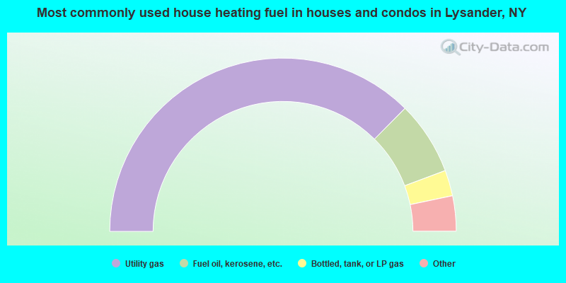
- 74.9%Utility gas
- 13.7%Fuel oil, kerosene, etc.
- 4.8%Bottled, tank, or LP gas
- 4.0%Electricity
- 2.6%Wood
- 0.1%Other fuel
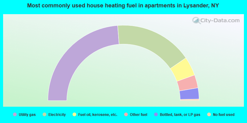
- 47.5%Utility gas
- 33.3%Electricity
- 8.1%Fuel oil, kerosene, etc.
- 5.6%Other fuel
- 4.8%Bottled, tank, or LP gas
- 0.6%No fuel used
Lysander compared to New York state average:
- Median house value below state average.
- Unemployed percentage significantly below state average.
- Black race population percentage significantly below state average.
- Hispanic race population percentage significantly below state average.
- Foreign-born population percentage significantly below state average.
- Renting percentage significantly below state average.
- Length of stay since moving in significantly above state average.
- Number of rooms per house significantly below state average.
- House age significantly below state average.
Lysander on our top lists:
- #17 on the list of "Top 101 cities with largest percentage of males in industries: beverage and tobacco products (population 5,000+)"
- #29 on the list of "Top 101 cities with largest percentage of females in industries: farm product raw materials merchant wholesalers (population 5,000+)"
- #41 on the list of "Top 101 cities with largest percentage of males in occupations: operations specialties managers except financial managers (population 5,000+)"
- #49 on the list of "Top 101 cities with largest percentage of females in industries: beverage and tobacco products (population 5,000+)"
- #58 on the list of "Top 101 cities with largest percentage of males in industries: drugs, sundries, and chemical and allied products merchant wholesalers (population 5,000+)"
- #60 on the list of "Top 101 cities with largest percentage of males in occupations: advertising, marketing, promotions, public relations, and sales managers (population 5,000+)"
- #62 on the list of "Top 101 cities with largest percentage of females in industries: electrical equipment, appliances, and components (population 5,000+)"
- #71 on the list of "Top 101 cities with largest percentage of females in occupations: preschool, kindergarten, elementary and middle school teachers (population 5,000+)"
- #76 on the list of "Top 101 cities with largest percentage of females in occupations: religious workers (population 5,000+)"
- #87 on the list of "Top 101 cities with largest percentage of females in industries: machinery (population 5,000+)"
- #96 on the list of "Top 101 cities with largest percentage of males in industries: groceries and related products merchant wholesalers (population 5,000+)"
- #98 on the list of "Top 101 cities with largest percentage of males in occupations: engineers (population 5,000+)"
- #98 on the list of "Top 101 cities with largest percentage of males in occupations: other healthcare support occupations (population 5,000+)"
- #31 on the list of "Top 101 counties with the largest decrease in the number of infant deaths per 1000 residents 2000-2006 to 2007-2013 (pop. 50,000+)"
- #41 on the list of "Top 101 counties with the most Orthodox congregations"
- #42 on the list of "Top 101 counties with the most Catholic congregations"
- #64 on the list of "Top 101 counties with the lowest percentage of residents relocating from other counties between 2010 and 2011 (pop. 50,000+)"
- #65 on the list of "Top 101 counties with the lowest Sulfur Oxides Annual air pollution readings in 2012 (µg/m3)"