Lyndon, Wisconsin
Submit your own pictures of this town and show them to the world
- OSM Map
- Google Map
- MSN Map
Population change since 2000: +5.0%
| Males: 808 | |
| Females: 734 |
| Median resident age: | 45.4 years |
| Wisconsin median age: | 42.6 years |
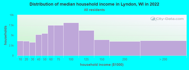
| Lyndon: | $76,441 |
| WI: | $70,996 |
Estimated per capita income in 2022: $36,818 (it was $21,727 in 2000)
Lyndon town income, earnings, and wages data
Estimated median house or condo value in 2022: $263,837 (it was $130,500 in 2000)
| Lyndon: | $263,837 |
| WI: | $252,800 |
Mean prices in 2022: all housing units: $292,018; detached houses: $260,266; townhouses or other attached units: $266,379; in 2-unit structures: $150,163; in 3-to-4-unit structures: $200,868; in 5-or-more-unit structures: over $1,000,000; mobile homes: $53,227
Detailed information about poverty and poor residents in Lyndon, WI
Compare current foreclosures near Lyndon, WI:
| Photo | Address | Area | Beds / Baths | Price | Details |
|---|---|---|---|---|---|

|
#1
S 15th St
Sheboygan, WI 53081
|
1,189 sq. feet
|
1 baths 3 beds |
show details | |

|
#2
Oakland Ave
Sheboygan, WI 53081
|
1,233 sq. feet
|
1 baths 3 beds |
show details | |

|
#3
Washington Ave
Sheboygan, WI 53081
|
864 sq. feet
|
1 baths 2 beds |
show details | |

|
#4
Broadway Ave
Sheboygan, WI 53081
|
1,194 sq. feet
|
2 baths 2 beds |
show details | |

|
#5
S 11th St
Sheboygan, WI 53081
|
1,355 sq. feet
|
1 baths 3 beds |
show details | |

|
#6
N 29th St
Sheboygan, WI 53083
|
1,125 sq. feet
|
1 baths 3 beds |
show details | |

|
#7
North Ave
Sheboygan, WI 53083
|
1,252 sq. feet
|
1 baths 4 beds |
show details | |

|
#8
N 15th St
Sheboygan, WI 53081
|
980 sq. feet
|
1 baths 3 beds |
show details | |

|
#9
S 13th St
Sheboygan, WI 53081
|
1,524 sq. feet
|
2 baths 3 beds |
show details | |

|
#10
Erie Ave
Sheboygan, WI 53081
|
1,230 sq. feet
|
1 baths 3 beds |
show details |
| Photo | Address | Area | Beds / Baths | Price | Details |
|---|---|---|---|---|---|

|
#11
Leon Ct
Sheboygan, WI 53081
|
1,176 sq. feet
|
1 baths 3 beds |
show details | |

|
#12
N 21st St
Sheboygan, WI 53083
|
2,189 sq. feet
|
2 baths 4 beds |
show details | |

|
#13
Macarthur Ave
Sheboygan, WI 53083
|
1,500 sq. feet
|
1 baths 4 beds |
show details | |

|
#14
S 19th St
Sheboygan, WI 53081
|
1,311 sq. feet
|
1 baths 3 beds |
show details | |

|
#15
Heller Ave
Sheboygan, WI 53081
|
2,408 sq. feet
|
2 baths 6 beds |
show details | |

|
#16
N 22nd St
Sheboygan, WI 53083
|
1,290 sq. feet
|
1 baths 3 beds |
show details | |

|
#17
Georgia Ave
Sheboygan, WI 53081
|
1,130 sq. feet
|
1 baths 3 beds |
show details | |

|
#18
S 13th St
Sheboygan, WI 53081
|
1,361 sq. feet
|
1 baths 3 beds |
show details | |

|
#19
Whitcomb Ave
Sheboygan, WI 53081
|
1,331 sq. feet
|
1 baths 2 beds |
show details | |

|
#20
N 37th St
Sheboygan, WI 53081
|
1,092 sq. feet
|
1 baths 3 beds |
show details |
| Photo | Address | Area | Beds / Baths | Price | Details |
|---|---|---|---|---|---|

|
#21
N 9th St
Sheboygan, WI 53081
|
2,186 sq. feet
|
2 baths 4 beds |
show details | |

|
#22
Superior Ave
Sheboygan, WI 53081
|
1,495 sq. feet
|
1 baths 3 beds |
show details | |

|
#23
S 14th St
Sheboygan, WI 53081
|
1,741 sq. feet
|
1 baths 6 beds |
show details | |

|
#24
Georgia Ave
Sheboygan, WI 53081
|
1,248 sq. feet
|
1 baths 3 beds |
show details | |

|
#25
S 21st St
Sheboygan, WI 53081
|
1,170 sq. feet
|
1 baths 3 beds |
show details | |

|
#26
S 22nd St
Sheboygan, WI 53081
|
1,542 sq. feet
|
2 baths 4 beds |
show details | |

|
#27
N 36th St
Sheboygan, WI 53083
|
1,788 sq. feet
|
2 baths 4 beds |
show details | |

|
#28
N 30th St
Sheboygan, WI 53081
|
1,272 sq. feet
|
2 baths 3 beds |
show details | |

|
#29
Michigan Ave
Sheboygan, WI 53081
|
1,830 sq. feet
|
1 baths 3 beds |
show details | |

|
#30
N 31st Pl
Sheboygan, WI 53083
|
2,320 sq. feet
|
2 baths 2 beds |
show details |
| Photo | Address | Area | Beds / Baths | Price | Details |
|---|---|---|---|---|---|

|
#31
N 4th St
Sheboygan, WI 53081
|
1,376 sq. feet
|
1 baths 3 beds |
show details | |

|
#32
N 8th St
Sheboygan, WI 53081
|
1,428 sq. feet
|
1 baths 3 beds |
show details | |

|
#33
Pershing Ave
Sheboygan, WI 53083
|
1,008 sq. feet
|
1 baths 3 beds |
show details | |

|
#34
Macarthur Ave
Sheboygan, WI 53083
|
944 sq. feet
|
1 baths 3 beds |
show details | |

|
#35
Niagara Ave
Sheboygan, WI 53081
|
2,356 sq. feet
|
2 baths 4 beds |
show details | |

|
#36
S 22nd St
Sheboygan, WI 53081
|
1,470 sq. feet
|
1 baths 4 beds |
show details | |

|
#37
S 19th St
Sheboygan, WI 53081
|
1,104 sq. feet
|
1 baths 3 beds |
show details | |

|
#38
S 19th St
Sheboygan, WI 53081
|
1,032 sq. feet
|
1 baths 3 beds |
show details | |

|
#39
N 24th St
Sheboygan, WI 53083
|
1,050 sq. feet
|
1 baths 3 beds |
show details | |

|
#40
Bartelt Ln
Campbellsport, WI 53010
|
- sq. feet
|
- baths - beds |
show details |
| Photo | Address | Area | Beds / Baths | Price | Details |
|---|---|---|---|---|---|

|
#41
Georgia Ave
Sheboygan, WI 53081
|
- sq. feet
|
- baths - beds |
show details | |

|
#42
Henry St # A
Sheboygan, WI 53081
|
- sq. feet
|
- baths - beds |
show details | |

|
#43
Henry St
Sheboygan, WI 53081
|
- sq. feet
|
- baths - beds |
show details | |

|
#44
Maryland Ave
Sheboygan, WI 53081
|
- sq. feet
|
- baths - beds |
show details | |

|
#45
Log Cabin Ln
Belgium, WI 53004
|
- sq. feet
|
- baths - beds |
show details | |

|
#46
Illinois Ave
Sheboygan, WI 53081
|
- sq. feet
|
- baths - beds |
show details | |

|
#47
Larkspur Way
Sheboygan, WI 53083
|
- sq. feet
|
- baths - beds |
show details | |

|
#48
Main St Apt 106
Belgium, WI 53004
|
- sq. feet
|
- baths - beds |
show details | |

|
#49
Kroos Ct
Sheboygan, WI 53083
|
- sq. feet
|
- baths - beds |
show details | |

|
Check over 1 million property listings on Foreclosure.com!
|
browse all offers | |||

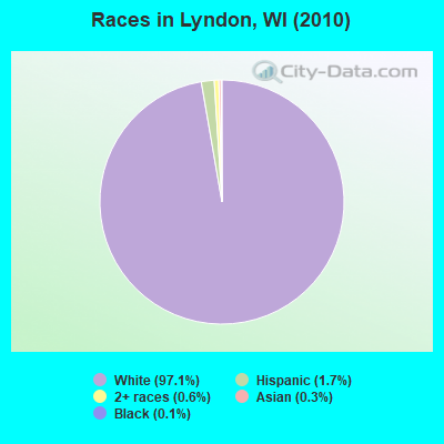
- 1,49797.1%White alone
- 261.7%Hispanic
- 100.6%Two or more races
- 50.3%Asian alone
- 20.1%Black alone
- 10.06%American Indian alone
- 10.06%Other race alone
Races in Lyndon detailed stats: ancestries, foreign born residents, place of birth
According to our research of Wisconsin and other state lists, there was 1 registered sex offender living in Lyndon, Wisconsin as of May 11, 2024.
The ratio of all residents to sex offenders in Lyndon is 1,542 to 1.
The ratio of registered sex offenders to all residents in this city is much lower than the state average.
 Recent articles from our blog. Our writers, many of them Ph.D. graduates or candidates, create easy-to-read articles on a wide variety of topics.
Ancestries: German (55.0%), Irish (11.5%), Dutch (6.3%), English (5.6%), French (4.9%), Polish (4.8%).
Current Local Time: CST time zone
Land area: 34.2 square miles.
Population density: 45 people per square mile (very low).
6 residents are foreign born
| This town: | 0.4% |
| Wisconsin: | 3.6% |
| Lyndon town: | 1.4% ($1,868) |
| Wisconsin: | 2.0% ($2,245) |
Nearest city with pop. 50,000+: Sheboygan, WI  (13.9 miles , pop. 50,792).
Nearest city with pop. 200,000+: Milwaukee, WI (42.9 miles , pop. 596,974).
Nearest city with pop. 1,000,000+: Chicago, IL (127.6 miles , pop. 2,896,016).
Nearest cities:
), ), ), ), ), ), )Latitude: 43.67 N, Longitude: 87.98 W
Area code commonly used in this area: 920
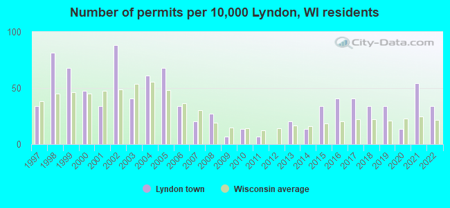
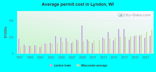
Single-family new house construction building permits:
- 2022: 5 buildings, average cost: $273,300
- 2021: 8 buildings, average cost: $244,800
- 2020: 2 buildings, average cost: $278,400
- 2019: 5 buildings, average cost: $270,700
- 2018: 5 buildings, average cost: $214,500
- 2017: 6 buildings, average cost: $378,000
- 2016: 6 buildings, average cost: $378,000
- 2015: 5 buildings, average cost: $205,600
- 2014: 2 buildings, average cost: $332,500
- 2013: 3 buildings, average cost: $244,400
- 2011: 1 building, cost: $165,000
- 2010: 2 buildings, average cost: $218,500
- 2009: 1 building, cost: $431,100
- 2008: 4 buildings, average cost: $218,500
- 2007: 3 buildings, average cost: $165,300
- 2006: 5 buildings, average cost: $238,800
- 2005: 10 buildings, average cost: $246,500
- 2004: 9 buildings, average cost: $270,600
- 2003: 6 buildings, average cost: $170,800
- 2002: 13 buildings, average cost: $160,900
- 2001: 5 buildings, average cost: $103,000
- 2000: 7 buildings, average cost: $129,100
- 1999: 10 buildings, average cost: $125,300
- 1998: 12 buildings, average cost: $142,900
- 1997: 5 buildings, average cost: $234,000
| Here: | 2.1% |
| Wisconsin: | 2.7% |
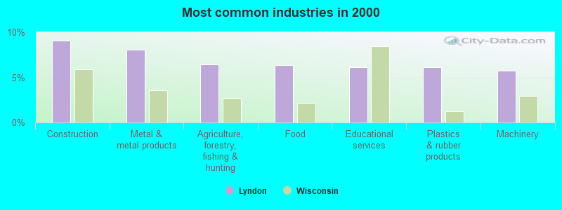
- Construction (9.1%)
- Metal & metal products (8.0%)
- Agriculture, forestry, fishing & hunting (6.5%)
- Food (6.3%)
- Educational services (6.1%)
- Plastics & rubber products (6.1%)
- Machinery (5.7%)
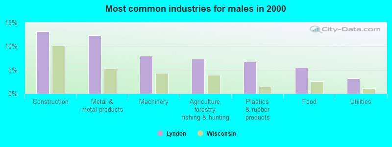
- Construction (13.2%)
- Metal & metal products (12.3%)
- Machinery (8.0%)
- Agriculture, forestry, fishing & hunting (7.3%)
- Plastics & rubber products (6.7%)
- Food (5.6%)
- Utilities (3.2%)
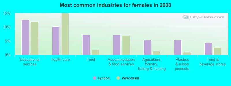
- Educational services (12.6%)
- Health care (10.2%)
- Food (7.3%)
- Accommodation & food services (7.3%)
- Agriculture, forestry, fishing & hunting (5.4%)
- Plastics & rubber products (5.4%)
- Food & beverage stores (4.3%)
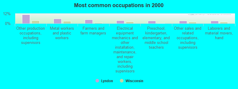
- Other production occupations, including supervisors (10.9%)
- Metal workers and plastic workers (5.7%)
- Farmers and farm managers (4.7%)
- Electrical equipment mechanics and other installation, maintenance, and repair workers, including supervisors (3.7%)
- Preschool, kindergarten, elementary, and middle school teachers (3.2%)
- Other sales and related occupations, including supervisors (3.2%)
- Laborers and material movers, hand (3.2%)
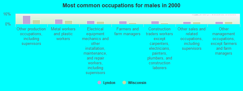
- Other production occupations, including supervisors (13.4%)
- Metal workers and plastic workers (7.8%)
- Electrical equipment mechanics and other installation, maintenance, and repair workers, including supervisors (5.4%)
- Farmers and farm managers (4.8%)
- Construction traders workers except carpenters, electricians, painters, plumbers, and construction laborers (4.8%)
- Other sales and related occupations, including supervisors (4.1%)
- Other management occupations, except farmers and farm managers (3.9%)

- Other production occupations, including supervisors (7.8%)
- Preschool, kindergarten, elementary, and middle school teachers (6.7%)
- Other teachers, instructors, education, training, and library occupations (6.5%)
- Cashiers (4.8%)
- Secretaries and administrative assistants (4.8%)
- Farmers and farm managers (4.6%)
- Information and record clerks, except customer service representatives (4.6%)
Average climate in Lyndon, Wisconsin
Based on data reported by over 4,000 weather stations


(lower is better)
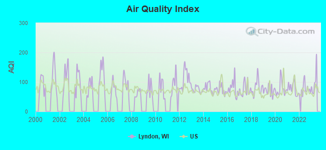
Air Quality Index (AQI) level in 2022 was 75.5. This is about average.
| City: | 75.5 |
| U.S.: | 72.6 |
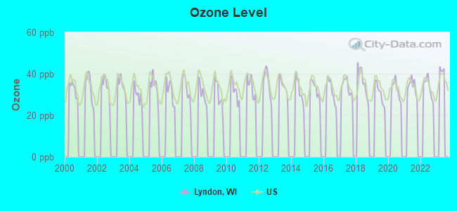
Ozone [ppb] level in 2022 was 33.8. This is about average. Closest monitor was 4.5 miles away from the city center.
| City: | 33.8 |
| U.S.: | 33.3 |
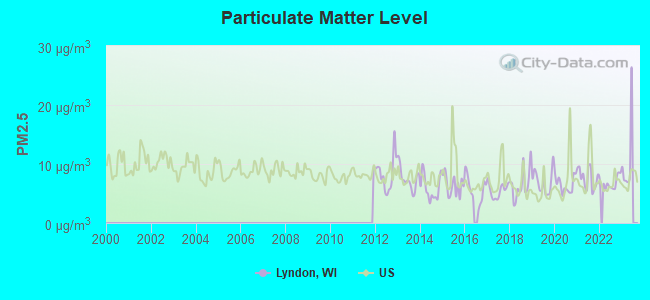
Particulate Matter (PM2.5) [µg/m3] level in 2022 was 6.81. This is about average. Closest monitor was 14.7 miles away from the city center.
| City: | 6.81 |
| U.S.: | 8.11 |
Tornado activity:
Lyndon-area historical tornado activity is near Wisconsin state average. It is 18% greater than the overall U.S. average.
On 7/18/1996, a category F5 (max. wind speeds 261-318 mph) tornado 20.2 miles away from the Lyndon town center injured 12 people and caused $40 million in damages.
On 4/4/1981, a category F4 (max. wind speeds 207-260 mph) tornado 20.0 miles away from the town center killed 3 people and injured 53 people and caused between $5,000,000 and $50,000,000 in damages.
Earthquake activity:
Lyndon-area historical earthquake activity is significantly above Wisconsin state average. It is 6% smaller than the overall U.S. average.On 4/18/2008 at 09:36:59, a magnitude 5.4 (5.1 MB, 4.8 MS, 5.4 MW, 5.2 MW, Class: Moderate, Intensity: VI - VII) earthquake occurred 361.1 miles away from the city center
On 6/28/2004 at 06:10:52, a magnitude 4.2 (4.2 MW, Depth: 6.2 mi, Class: Light, Intensity: IV - V) earthquake occurred 160.0 miles away from Lyndon center
On 5/2/2015 at 16:23:07, a magnitude 4.2 (4.2 MW, Depth: 2.8 mi) earthquake occurred 163.0 miles away from Lyndon center
On 6/10/1987 at 23:48:54, a magnitude 5.1 (4.9 MB, 4.4 MS, 4.6 MS, 5.1 LG) earthquake occurred 335.5 miles away from Lyndon center
On 4/18/2008 at 09:36:59, a magnitude 5.2 (5.2 MW, Depth: 8.9 mi) earthquake occurred 361.1 miles away from the city center
On 2/10/2010 at 09:59:35, a magnitude 3.8 (3.8 MW, Depth: 6.2 mi, Class: Light, Intensity: II - III) earthquake occurred 120.6 miles away from Lyndon center
Magnitude types: regional Lg-wave magnitude (LG), body-wave magnitude (MB), surface-wave magnitude (MS), moment magnitude (MW)
Natural disasters:
The number of natural disasters in Sheboygan County (10) is smaller than the US average (15).Major Disasters (Presidential) Declared: 8
Emergencies Declared: 2
Causes of natural disasters: Floods: 6, Storms: 6, Tornadoes: 2, Hurricane: 1, Wind: 1, Winter Storm: 1, Other: 1 (Note: some incidents may be assigned to more than one category).
Hospitals and medical centers near Lyndon:
- PLYMOUTH CARE CENTER, LLC (Nursing Home, about 5 miles away; PLYMOUTH, WI)
- VALLEY MANOR NURSING HOME (Nursing Home, about 5 miles away; PLYMOUTH, WI)
- AURORA VALLEY VIEW MEDICAL CENTER (Hospital, about 6 miles away; PLYMOUTH, WI)
- PINE HAVEN CHRISTIAN HOME (Nursing Home, about 9 miles away; SHEBOYGAN FALLS, WI)
- HOSPICE ADVANTAGE (Hospital, about 12 miles away; SHEBOYGAN, WI)
- SUNNY RIDGE (Nursing Home, about 14 miles away; SHEBOYGAN, WI)
- SUNNY RIDGE HEALTH AND REHAB CENTER (Nursing Home, about 14 miles away; SHEBOYGAN, WI)
Colleges/universities with over 2000 students nearest to Lyndon:
- Lakeland College (about 13 miles; Plymouth, WI; Full-time enrollment: 2,395)
- Marian University (about 24 miles; Fond Du Lac, WI; FT enrollment: 2,045)
- Moraine Park Technical College (about 24 miles; Fond du Lac, WI; FT enrollment: 3,079)
- Concordia University-Wisconsin (about 30 miles; Mequon, WI; FT enrollment: 5,253)
- Cardinal Stritch University (about 37 miles; Milwaukee, WI; FT enrollment: 3,595)
- University of Wisconsin-Oshkosh (about 38 miles; Oshkosh, WI; FT enrollment: 10,637)
- University of Wisconsin-Milwaukee (about 42 miles; Milwaukee, WI; FT enrollment: 24,196)
Points of interest:
Notable locations in Lyndon: Waldo Volunteer Fire Department (A), Cascade Volunteer Fire Department (B). Display/hide their locations on the map
Cemeteries: Harmon Cemetery (1), Winooski Cemetery (2), Lyndon Cemetery (3), Saint Pauls Cemetery (4), Waldo Cemetery (5). Display/hide their locations on the map
Lakes, reservoirs, and swamps: Lake Ellen (A), Waldo Millpond 22 (B), Waldo Mill Pond (C), Cascade Swamp (D). Display/hide their locations on the map
Creeks: Ben Nutt Creek (A), Mill Creek (B). Display/hide their locations on the map
Park in Lyndon: Nichols Creek State Wildlife Area (1). Display/hide its location on the map
| This town: | 2.6 people |
| Wisconsin: | 2.4 people |
| This town: | 77.8% |
| Whole state: | 64.4% |
| This town: | 6.8% |
| Whole state: | 7.3% |
Likely homosexual households (counted as self-reported same-sex unmarried-partner households)
- Lesbian couples: 0.3% of all households
- Gay men: 0.0% of all households
| This town: | 5.5% |
| Whole state: | 8.7% |
| This town: | 3.6% |
| Whole state: | 3.7% |
For population 15 years and over in Lyndon:
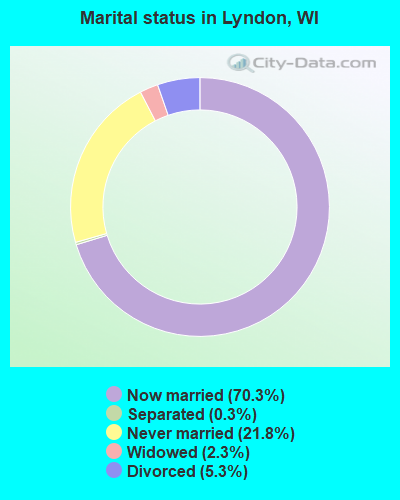
- Never married: 21.8%
- Now married: 70.3%
- Separated: 0.3%
- Widowed: 2.3%
- Divorced: 5.3%
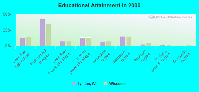
For population 25 years and over in Lyndon:
- High school or higher: 87.9%
- Bachelor's degree or higher: 18.7%
- Graduate or professional degree: 3.5%
- Unemployed: 3.1%
- Mean travel time to work (commute): 22.5 minutes
| Here: | 9.1 |
| Wisconsin average: | 11.0 |
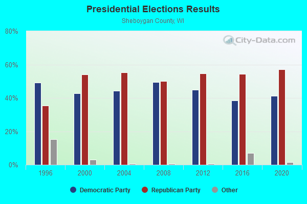
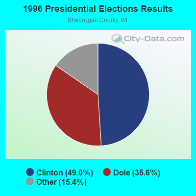
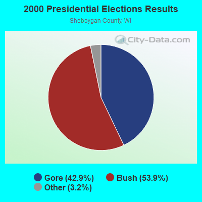
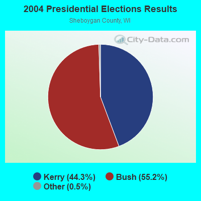
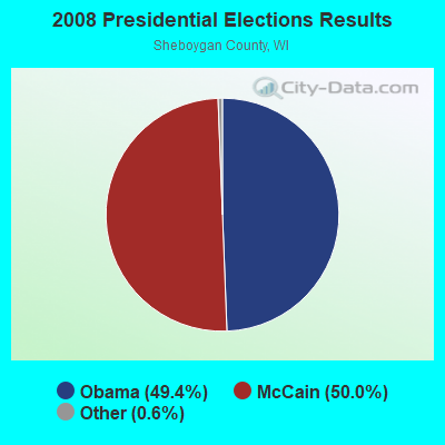
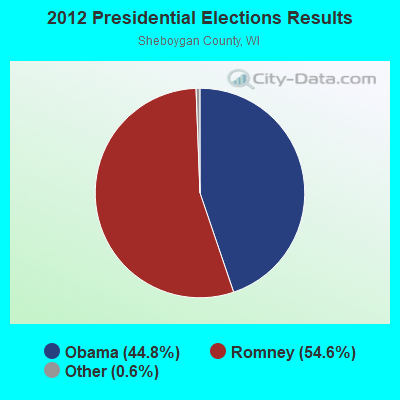
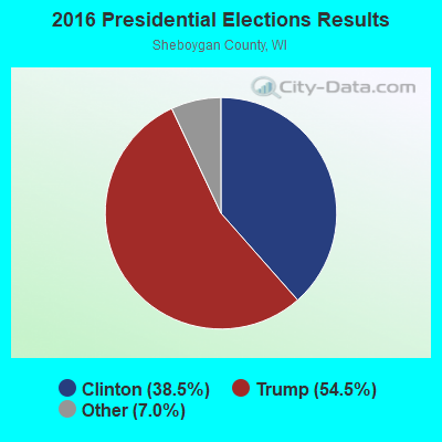
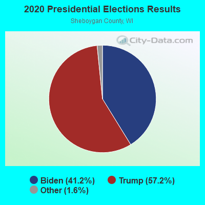
Graphs represent county-level data. Detailed 2008 Election Results
Religion statistics for Lyndon, WI (based on Sheboygan County data)
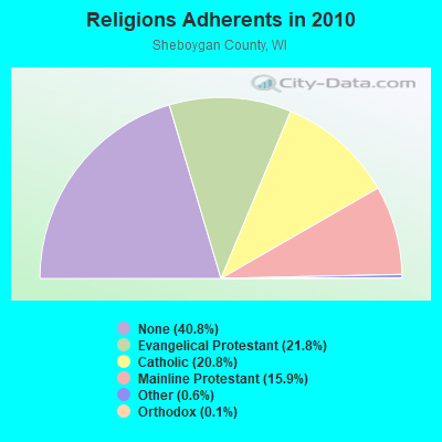
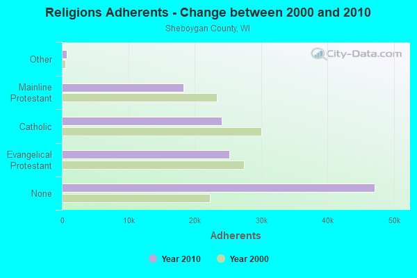
| Religion | Adherents | Congregations |
|---|---|---|
| Evangelical Protestant | 25,183 | 72 |
| Catholic | 24,036 | 11 |
| Mainline Protestant | 18,339 | 43 |
| Other | 686 | 7 |
| Orthodox | 145 | 1 |
| None | 47,118 | - |
Food Environment Statistics:
| This county: | 1.66 / 10,000 pop. |
| State: | 1.86 / 10,000 pop. |
| Sheboygan County: | 0.09 / 10,000 pop. |
| State: | 0.11 / 10,000 pop. |
| Here: | 0.09 / 10,000 pop. |
| State: | 0.38 / 10,000 pop. |
| This county: | 4.03 / 10,000 pop. |
| Wisconsin: | 4.12 / 10,000 pop. |
| Sheboygan County: | 8.49 / 10,000 pop. |
| Wisconsin: | 8.64 / 10,000 pop. |
| Sheboygan County: | 7.1% |
| Wisconsin: | 7.6% |
| Sheboygan County: | 26.5% |
| Wisconsin: | 27.5% |
| Here: | 13.3% |
| Wisconsin: | 13.0% |
Strongest AM radio stations in Lyndon:
- WNAM (1280 AM; 50 kW; NEENAH-MENASHA, WI; Owner: CUMULUS LICENSING CORP.)
- WHBL (1330 AM; 5 kW; SHEBOYGAN, WI; Owner: MIDWEST COMMUNICATIONS, INC.)
- WTMJ (620 AM; 50 kW; MILWAUKEE, WI; Owner: JOURNAL BROADCAST CORPORATION)
- WJUB (1420 AM; 0 kW; PLYMOUTH, WI)
- WHBY (1150 AM; 25 kW; KIMBERLY, WI; Owner: WOODWARD COMMUNICATIONS, INC.)
- WISN (1130 AM; 50 kW; MILWAUKEE, WI; Owner: CAPSTAR TX LIMITED PARTNERSHIP)
- WCLB (950 AM; 0 kW; SHEBOYGAN, WI; Owner: RBH ENTERPRISES, INC. D/B/A YELLOW DOG BROADCASTING)
- WCUB (980 AM; 5 kW; TWO RIVERS, WI; Owner: CUB RADIO, INC.)
- WGN (720 AM; 50 kW; CHICAGO, IL; Owner: WGN CONTINENTAL BROADCASTING CO.)
- WSPT (1010 AM; 50 kW; STEVENS POINT, WI)
- WSCR (670 AM; 50 kW; CHICAGO, IL; Owner: INFINITY BROADCASTING OPERATIONS, INC.)
- WBBM (780 AM; 50 kW; CHICAGO, IL; Owner: INFINITY BROADCASTING OPERATIONS, INC.)
- WKSH (1640 AM; 10 kW; SUSSEX, WI; Owner: ABC, INC.)
Strongest FM radio stations in Lyndon:
- WSTM (91.3 FM; KIEL, WI; Owner: JUBILATION MINISTRIES INC)
- WXER (104.5 FM; PLYMOUTH, WI; Owner: RBH ENTERPRISES, INC. D/B/A YELLOW DOG BROADCASTING)
- WBFM (93.7 FM; SHEBOYGAN, WI; Owner: MIDWEST COMMUNICATIONS, INC.)
- WBWI-FM (92.5 FM; WEST BEND, WI; Owner: WEST BEND BROADCASTING CO.)
- WHBZ (106.5 FM; SHEBOYGAN FALLS, WI; Owner: MIDWEST COMMUNICATIONS, INC.)
- WGLB-FM (100.1 FM; PORT WASHINGTON, WI; Owner: STARBOARD MEDIA FOUNDATION, INC.)
- WAPL-FM (105.7 FM; APPLETON, WI; Owner: WOODWARD COMMUNICATIONS, INC.)
- WMIL-FM (106.1 FM; WAUKESHA, WI; Owner: CLEAR CHANNEL BROADCASTING LICENSES, INC.)
- WJZI (93.3 FM; MILWAUKEE, WI; Owner: MILWAUKEE RADIO ALLIANCE, LLC)
- WLTQ (97.3 FM; MILWAUKEE, WI; Owner: CAPSTAR TX LIMITED PARTNERSHIP)
- WKTI-FM (94.5 FM; MILWAUKEE, WI; Owner: JOURNAL BROADCAST CORPORATION)
- W255AC (98.9 FM; SHEBOYGAN, WI; Owner: FAMILY EDUCATIONAL BROADCASTING CORP)
- WUWM (89.7 FM; MILWAUKEE, WI; Owner: BOARD OF REGENTS, UNIVERSITY OF WISCONSIN SYSTEM)
- WXSS (103.7 FM; WAUWATOSA, WI; Owner: ENTERCOM MILWAUKEE LICENSE, LLC)
- WKLH (96.5 FM; MILWAUKEE, WI; Owner: LAKEFRONT COMMUNICATIONS, LLC)
- KFIZ-FM (107.1 FM; FOND DU LAC, WI; Owner: RBH ENTERPRISES, INC.)
- WLKN (98.1 FM; CLEVELAND, WI; Owner: RADIO K-T, INC.)
TV broadcast stations around Lyndon:
- WMMF-TV (Channel 68; FOND DU LAC, WI; Owner: PAPPAS TELECASTING OF WISCONSIN, A CALIFORNIA LTD PARTNRSHP)
- WWRS-TV (Channel 52; MAYVILLE, WI; Owner: NATIONAL MINORITY T.V., INC.)
- W16BS (Channel 16; SHEBOYGAN, WI; Owner: TRINITY BROADCASTING NETWORK)
- WITI (Channel 6; MILWAUKEE, WI; Owner: WITI LICENSE,INC.)
- WDJT-TV (Channel 58; MILWAUKEE, WI; Owner: WDJT-TV LIMITED PARTNERSHIP)
- WISN-TV (Channel 12; MILWAUKEE, WI; Owner: WISN HEARST-ARGYLE TV, INC. (CA CORP.))
- WLUK-TV (Channel 11; GREEN BAY, WI; Owner: EMMIS TELEVISION LICENSE CORPORATION)
- WFRV-TV (Channel 5; GREEN BAY, WI; Owner: CBS BROADCASTING INC.)
- WPXE (Channel 55; KENOSHA, WI; Owner: PAXSON MILWAUKEE LICENSE, INC.)
- WMVS (Channel 10; MILWAUKEE, WI; Owner: MILWAUKEE AREA TECHNICAL COLLEGE DISTRICT BOARD)
- WMVT (Channel 36; MILWAUKEE, WI; Owner: MILWAUKEE AREA TECHNICAL COLLEGE DISTRICT BOARD)
- WMLW-CA (Channel 46; MILWAUKEE, WI; Owner: CHANNEL 41 AND 63 LIMITED PARTNERSHIP)
- W63CU (Channel 63; MILWAUKEE, WI; Owner: CHANNEL 41 AND 63 LIMITED PARTNERSHIP)
- WCGV-TV (Channel 24; MILWAUKEE, WI; Owner: WCGV LICENSEE, LLC)
- WVTV (Channel 18; MILWAUKEE, WI; Owner: WVTV LICENSEE, INC.)
- WTMJ-TV (Channel 4; MILWAUKEE, WI; Owner: JOURNAL BROADCAST CORPORATION)
- WVCY-TV (Channel 30; MILWAUKEE, WI; Owner: VCY AMERICA, INC.)
- National Bridge Inventory (NBI) Statistics
- 12Number of bridges
- 49ft / 15.4mTotal length
- $614,000Total costs
- 7,826Total average daily traffic
- 25Total average daily truck traffic
- 8,602Total future (year 2039) average daily traffic
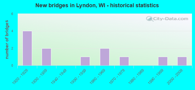
- New bridges - historical statistics
- 41920-1929
- 21930-1939
- 11950-1959
- 21960-1969
- 11970-1979
- 11990-1999
- 12000-2009
FCC Registered Antenna Towers:
4- Edward G Roach, N1233 63rd St. (Wi21284-A) (Lat: 43.681583 Lon: -89.834361), Type: 79.2, Structure height: 55057 m, Overall height: 76.2 m, Registrant: Sba Structures, LLC, Eroach@sbasite.Com, , Boca -Raton, Phone: (561) 995-7670
- Edward G Roach, N1233 63rd St. (Wi21284-A) (Lat: 43.681583 Lon: -89.834361), Type: 79.2, Structure height: 55057 m, Overall height: 76.2 m, Registrant: Sba Structures, LLC, Eroach@sbasite.Com, , Boca -Raton, Phone: (561) 995-7670
- Edward G Roach, N1233 63rd St. (Wi21284-A) (Lat: 43.681583 Lon: -89.834361), Type: 77.7, Structure height: 55057 m, Overall height: 76.2 m, Registrant: Sba Structures, LLC, Eroach@sbasite.Com, , Boca -Raton, Phone: (561) 995-7670
- Edward G Roach, N1233 63rd St. (Wi21284-A) (Lat: 43.681583 Lon: -89.834361), Type: 77.7, Structure height: 55057 m, Overall height: 76.2 m, Licensee ID: L, Registrant: Sba Structures, LLC, Eroach@sbasite.Com, , Boca -Raton, Phone: (561) 995-7670
FCC Registered Microwave Towers:
1- ML83621A, N1233 63rd St. (Wi21284-A) (Lat: 43.681583 Lon: -89.834361), Type: Ltower, Structure height: 76.2 m, Overall height: 79.2 m, Call Sign: WRPV525,
Assigned Frequencies: 10995.0 MHz, 10995.0 MHz, 10995.0 MHz, 10995.0 MHz, 10995.0 MHz, 10995.0 MHz, 10995.0 MHz, 10995.0 MHz, 10995.0 MHz, 10995.0 MHz... (+5 more), Grant Date: 03/22/2022, Expiration Date: 03/22/2032, Certifier: Jenny Knopf, Registrant: T-Mobile Usa, Inc., 12920 Se 38th Street, Bellevue, WA 98006, Phone: (425) 383-8401, Fax: (425) 383-4040, Email:
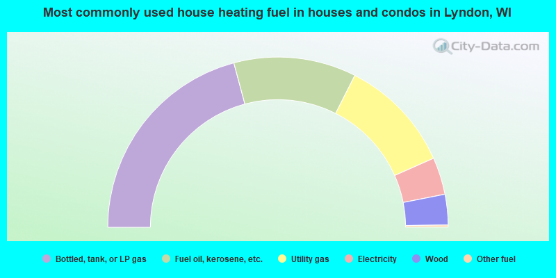
- 41.7%Bottled, tank, or LP gas
- 23.3%Fuel oil, kerosene, etc.
- 21.8%Utility gas
- 7.1%Electricity
- 5.8%Wood
- 0.4%Other fuel
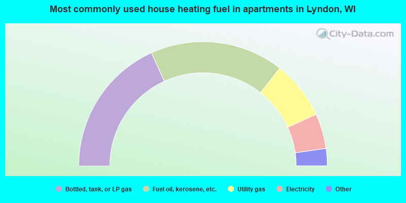
- 36.4%Bottled, tank, or LP gas
- 34.8%Fuel oil, kerosene, etc.
- 15.2%Utility gas
- 9.1%Electricity
- 3.0%Solar energy
- 1.5%No fuel used
Lyndon compared to Wisconsin state average:
- Unemployed percentage significantly below state average.
- Black race population percentage significantly below state average.
- Hispanic race population percentage significantly below state average.
- Foreign-born population percentage significantly below state average.
- Renting percentage significantly below state average.
- Length of stay since moving in significantly above state average.
- Number of rooms per house significantly below state average.
- House age significantly below state average.
- Number of college students below state average.