Lowell, Maine
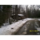
Lowell: View in the driveway on Dicks Lane, Rt. 188 Lowell Maine 3/11/2013
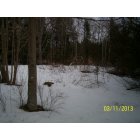
Lowell: part of my yard on Dicks Lane, Rt. 188 Lowell Maine 3/11/2013
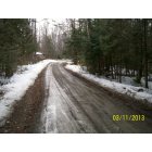
Lowell: Dicks Lane in Lowell Maine on March 11, 2013
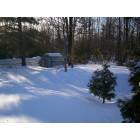
Lowell: RT. 188 LOWELL, MAINE . AT HOME
- add
your
Submit your own pictures of this town and show them to the world
- OSM Map
- General Map
- Google Map
- MSN Map
Population change since 2000: +23.0%
| Males: 184 | |
| Females: 174 |
| Median resident age: | 51.5 years |
| Maine median age: | 43.0 years |
Zip codes: 04493.
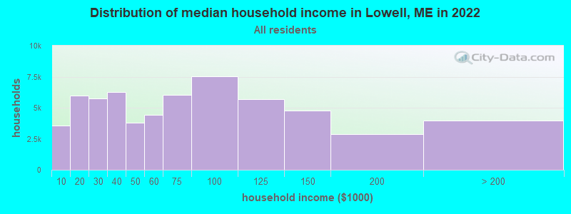
| Lowell: | $56,186 |
| ME: | $69,543 |
Estimated per capita income in 2022: $38,471 (it was $19,137 in 2000)
Lowell town income, earnings, and wages data
Estimated median house or condo value in 2022: $150,139 (it was $57,700 in 2000)
| Lowell: | $150,139 |
| ME: | $290,600 |
Mean prices in 2022: all housing units: $235,563; detached houses: $252,705; townhouses or other attached units: $267,749; in 2-unit structures: $255,332; in 3-to-4-unit structures: $815,300; in 5-or-more-unit structures: $185,873; mobile homes: $93,017; occupied boats, rvs, vans, etc.: $21,333
Detailed information about poverty and poor residents in Lowell, ME


- 34897.2%White alone
- 61.7%Two or more races
- 30.8%Asian alone
- 10.3%Hispanic

Races in Lowell detailed stats: ancestries, foreign born residents, place of birth
According to our research of Maine and other state lists, there was 1 registered sex offender living in Lowell, Maine as of May 08, 2024.
The ratio of all residents to sex offenders in Lowell is 358 to 1.
 Recent articles from our blog. Our writers, many of them Ph.D. graduates or candidates, create easy-to-read articles on a wide variety of topics.

 | Maine standards-what is a "pond" vs. what is a "lake?" (59 replies) |
| Found my Friend (8 replies) |
| Effects of Refugee Resettlement in Portland and Lewiston (46 replies) |
| Thinking of a move to Portland or nearby Portland (20 replies) |
| off grid living in maine (39 replies) |
| So Mass will get Canadian electricity via Maine (26 replies) |
Latest news from Lowell, ME collected exclusively by city-data.com from local newspapers, TV, and radio stations
Ancestries: English (14.1%), Irish (13.4%), French (10.7%), United States (10.7%), French Canadian (5.8%), German (5.2%).
Current Local Time: EST time zone
Incorporated on 02/09/1837
Elevation: 182 feet
Land area: 38.2 square miles.
Population density: 9.4 people per square mile (very low).
7 residents are foreign born (1.4% Europe, 1.0% North America).
| This town: | 2.4% |
| Maine: | 2.9% |
| Lowell town: | 1.3% ($771) |
| Maine: | 1.5% ($1,417) |
Nearest city with pop. 50,000+: Portland, ME  (139.0 miles , pop. 64,249).
Nearest city with pop. 200,000+: Boston, MA (238.9 miles , pop. 589,141).
Nearest city with pop. 1,000,000+: Bronx, NY (406.9 miles , pop. 1,332,650).
Nearest cities:
), ), Latitude: 45.21 N, Longitude: 68.47 W
Area code commonly used in this area: 207

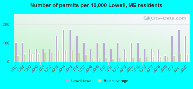
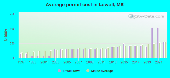
Single-family new house construction building permits:
- 2022: 4 buildings, average cost: $279,200
- 2021: 5 buildings, average cost: $525,000
- 2020: 4 buildings, average cost: $525,000
- 2019: 1 building, cost: $200,000
- 2018: 2 buildings, average cost: $212,500
- 2017: 2 buildings, average cost: $212,500
- 2016: 2 buildings, average cost: $212,500
- 2015: 3 buildings, average cost: $250,000
- 2014: 3 buildings, average cost: $187,500
- 2013: 2 buildings, average cost: $187,500
- 2012: 3 buildings, average cost: $150,000
- 2011: 2 buildings, average cost: $150,000
- 2010: 3 buildings, average cost: $150,000
- 2009: 3 buildings, average cost: $150,000
- 2008: 2 buildings, average cost: $150,000
- 2007: 3 buildings, average cost: $150,000
- 2006: 4 buildings, average cost: $150,000
- 2005: 5 buildings, average cost: $150,000
- 2004: 5 buildings, average cost: $150,000
- 2003: 4 buildings, average cost: $150,000
- 2002: 2 buildings, average cost: $37,500
- 2001: 2 buildings, average cost: $37,500
- 2000: 2 buildings, average cost: $37,500
- 1999: 2 buildings, average cost: $37,500
- 1998: 3 buildings, average cost: $80,000
- 1997: 3 buildings, average cost: $80,000
| Here: | 4.2% |
| Maine: | 3.4% |
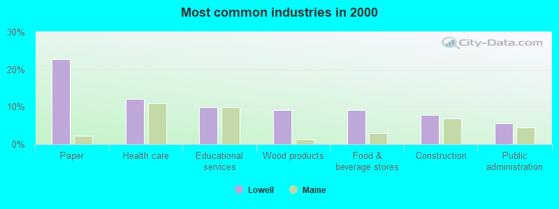
- Paper (22.7%)
- Health care (12.1%)
- Educational services (9.9%)
- Wood products (9.2%)
- Food & beverage stores (9.2%)
- Construction (7.8%)
- Public administration (5.7%)
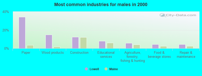
- Paper (34.1%)
- Wood products (14.8%)
- Construction (12.5%)
- Educational services (8.0%)
- Agriculture, forestry, fishing & hunting (5.7%)
- Food & beverage stores (4.5%)
- Repair & maintenance (4.5%)
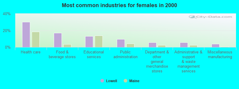
- Health care (30.2%)
- Food & beverage stores (17.0%)
- Educational services (13.2%)
- Public administration (9.4%)
- Department & other general merchandise stores (5.7%)
- Administrative & support & waste management services (5.7%)
- Miscellaneous manufacturing (3.8%)
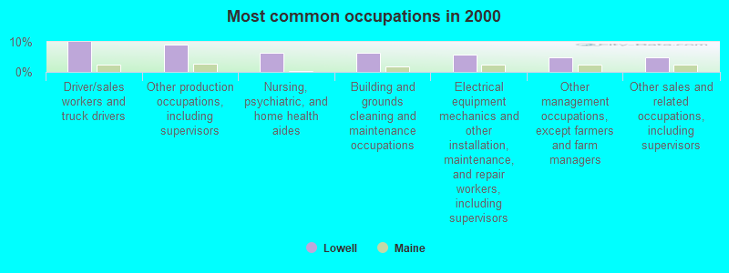
- Driver/sales workers and truck drivers (9.9%)
- Other production occupations, including supervisors (9.2%)
- Nursing, psychiatric, and home health aides (6.4%)
- Building and grounds cleaning and maintenance occupations (6.4%)
- Electrical equipment mechanics and other installation, maintenance, and repair workers, including supervisors (5.7%)
- Other management occupations, except farmers and farm managers (5.0%)
- Other sales and related occupations, including supervisors (5.0%)
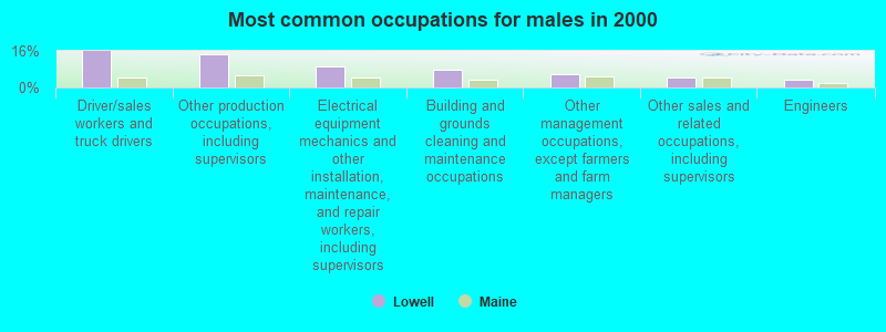
- Driver/sales workers and truck drivers (15.9%)
- Other production occupations, including supervisors (14.8%)
- Electrical equipment mechanics and other installation, maintenance, and repair workers, including supervisors (9.1%)
- Building and grounds cleaning and maintenance occupations (8.0%)
- Other management occupations, except farmers and farm managers (5.7%)
- Other sales and related occupations, including supervisors (4.5%)
- Engineers (3.4%)
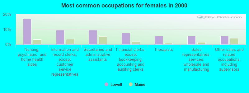
- Nursing, psychiatric, and home health aides (17.0%)
- Information and record clerks, except customer service representatives (9.4%)
- Secretaries and administrative assistants (9.4%)
- Financial clerks, except bookkeeping, accounting and auditing clerks (7.5%)
- Therapists (5.7%)
- Sales representatives, services, wholesale and manufacturing (5.7%)
- Other sales and related occupations, including supervisors (5.7%)
Average climate in Lowell, Maine
Based on data reported by over 4,000 weather stations


(lower is better)
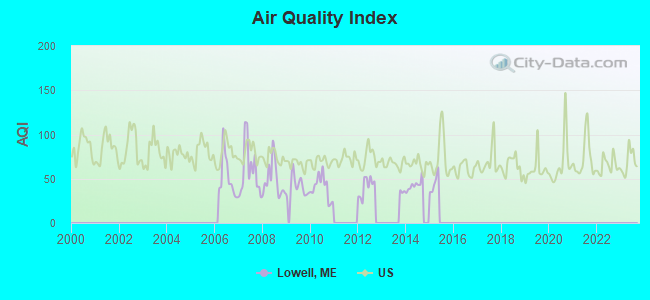
Air Quality Index (AQI) level in 2014 was 42.7. This is significantly better than average.
| City: | 42.7 |
| U.S.: | 72.6 |
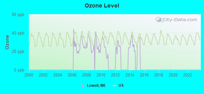
Ozone [ppb] level in 2015 was 16.3. This is significantly better than average. Closest monitor was 5.3 miles away from the city center.
| City: | 16.3 |
| U.S.: | 33.3 |
Earthquake activity:
Lowell-area historical earthquake activity is significantly above Maine state average. It is 82% smaller than the overall U.S. average.On 4/20/2002 at 10:50:47, a magnitude 5.3 (5.3 ML, Depth: 3.0 mi, Class: Moderate, Intensity: VI - VII) earthquake occurred 260.7 miles away from the city center
On 10/16/2012 at 23:12:25, a magnitude 4.7 (4.7 ML, Depth: 10.0 mi, Class: Light, Intensity: IV - V) earthquake occurred 155.3 miles away from Lowell center
On 4/20/2002 at 10:50:47, a magnitude 5.2 (5.2 MB, 4.2 MS, 5.2 MW, 5.0 MW) earthquake occurred 262.0 miles away from the city center
On 10/7/1983 at 10:18:46, a magnitude 5.3 (5.1 MB, 5.3 LG, 5.1 ML) earthquake occurred 301.9 miles away from Lowell center
On 1/19/1982 at 00:14:42, a magnitude 4.7 (4.5 MB, 4.7 MD, 4.5 LG) earthquake occurred 194.8 miles away from the city center
On 9/16/1994 at 04:22:42, a magnitude 3.6 (3.6 LG, Depth: 3.1 mi, Class: Light, Intensity: II - III) earthquake occurred 13.7 miles away from the city center
Magnitude types: regional Lg-wave magnitude (LG), body-wave magnitude (MB), duration magnitude (MD), local magnitude (ML), surface-wave magnitude (MS), moment magnitude (MW)
Natural disasters:
The number of natural disasters in Penobscot County (19) is greater than the US average (15).Major Disasters (Presidential) Declared: 11
Emergencies Declared: 7
Causes of natural disasters: Floods: 9, Storms: 8, Snows: 5, Heavy Rains: 2, Blizzard: 1, Hurricane: 1, Ice Storm: 1, Snowfall: 1, Wind: 1, Winter Storm: 1, Other: 2 (Note: some incidents may be assigned to more than one category).
Colleges/universities with over 2000 students nearest to Lowell:
- University of Maine (about 25 miles; Orono, ME; Full-time enrollment: 8,931)
- Husson University (about 31 miles; Bangor, ME; FT enrollment: 2,421)
- University of Maine at Augusta (about 89 miles; Augusta, ME; FT enrollment: 3,204)
- University of Maine at Farmington (about 91 miles; Farmington, ME; FT enrollment: 2,036)
- Saint Joseph's College of Maine (about 138 miles; Standish, ME; FT enrollment: 2,010)
- Southern Maine Community College (about 139 miles; South Portland, ME; FT enrollment: 4,666)
- University of Southern Maine (about 140 miles; Portland, ME; FT enrollment: 6,647)
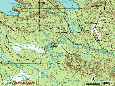
Points of interest:
Cemeteries: Lowell Cemetery (1), West End Cemetery (2). Display/hide their locations on the map
Lakes and reservoirs: Trout Pond (A), Eskutassis Pond (B), Pickerel Pond (C), Gristmill Pond (D). Display/hide their locations on the map
Streams, rivers, and creeks: Fogg Brook (A), Eskutassis Stream (B), Davis Brook (C), Clark Brook (D), Buck Brook (E). Display/hide their locations on the map
| This town: | 2.3 people |
| Maine: | 2.3 people |
| This town: | 76.0% |
| Whole state: | 62.9% |
| This town: | 9.1% |
| Whole state: | 9.4% |
Likely homosexual households (counted as self-reported same-sex unmarried-partner households)
- Lesbian couples: 0.0% of all households
- Gay men: 0.6% of all households
| This town: | 15.1% |
| Whole state: | 10.9% |
| This town: | 2.5% |
| Whole state: | 4.1% |
For population 15 years and over in Lowell:
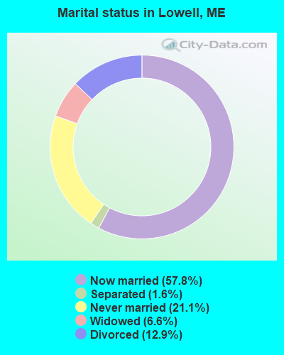
- Never married: 21.1%
- Now married: 57.8%
- Separated: 1.6%
- Widowed: 6.6%
- Divorced: 12.9%
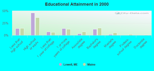
For population 25 years and over in Lowell:
- High school or higher: 85.8%
- Bachelor's degree or higher: 14.7%
- Graduate or professional degree: 2.0%
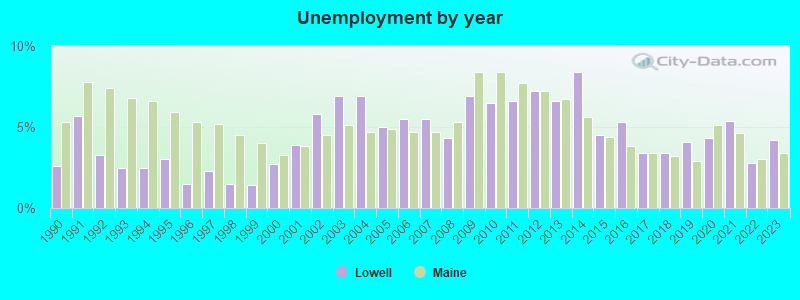
- Unemployed: 7.2%
- Mean travel time to work (commute): 37.2 minutes
| Here: | 9.7 |
| Maine average: | 11.2 |


Graphs represent county-level data. Detailed 2008 Election Results
Religion statistics for Lowell, ME (based on Penobscot County data)


| Religion | Adherents | Congregations |
|---|---|---|
| Catholic | 16,581 | 15 |
| Mainline Protestant | 9,715 | 59 |
| Evangelical Protestant | 7,523 | 80 |
| Other | 2,936 | 22 |
| Orthodox | 300 | 1 |
| None | 116,868 | - |
Food Environment Statistics:
| Penobscot County: | 2.29 / 10,000 pop. |
| State: | 2.80 / 10,000 pop. |
| Penobscot County: | 0.13 / 10,000 pop. |
| Maine: | 0.14 / 10,000 pop. |
| This county: | 2.56 / 10,000 pop. |
| Maine: | 2.20 / 10,000 pop. |
| This county: | 5.72 / 10,000 pop. |
| State: | 5.75 / 10,000 pop. |
| Penobscot County: | 7.41 / 10,000 pop. |
| Maine: | 11.02 / 10,000 pop. |
| This county: | 9.0% |
| State: | 8.2% |
| This county: | 28.0% |
| Maine: | 25.0% |
Strongest AM radio stations in Lowell:
- WZON (620 AM; 5 kW; BANGOR, ME; Owner: THE ZONE CORPORATION)
- WABI (910 AM; 5 kW; BANGOR, ME; Owner: CLEAR CHANNEL BROADCASTING LICENSES, INC.)
- WSKW (1160 AM; 10 kW; SKOWHEGAN, ME; Owner: MOUNTAIN WIRELESS, INCORPORATED)
- WDEA (1370 AM; 5 kW; ELLSWORTH, ME; Owner: CUMULUS LICENSING CORP.)
- WRKO (680 AM; 50 kW; BOSTON, MA; Owner: ENTERCOM BOSTON LICENSE, LLC)
- WNZS (1340 AM; 1 kW; VEAZIE, ME; Owner: WATERFRONT COMMUNICATIONS INC.)
- WTME (780 AM; 10 kW; RUMFORD, ME; Owner: MOUNTAIN VALLEY BROADCASTING, INC.)
- WREM (710 AM; daytime; 5 kW; MONTICELLO, ME; Owner: ALLAN H WEINER)
- WEEI (850 AM; 50 kW; BOSTON, MA; Owner: ENTERCOM BOSTON LICENSE, LLC)
- WBZ (1030 AM; 50 kW; BOSTON, MA; Owner: INFINITY BROADCASTING OPERATIONS, INC.)
- WNNZ (640 AM; 50 kW; WESTFIELD, MA; Owner: CLEAR CHANNEL BROADCASTING LICENSES, INC.)
- WCRN (830 AM; 50 kW; WORCESTER, MA; Owner: CARTER BROADCASTING CORPORATION)
- WCHP (760 AM; 35 kW; CHAMPLAIN, NY; Owner: CHAMPLAIN RADIO, INC.)
Strongest FM radio stations in Lowell:
- WVOM (103.9 FM; HOWLAND, ME; Owner: CLEAR CHANNEL BROADCASTING LICENSES, INC.)
- WHCF (88.5 FM; BANGOR, ME; Owner: BANGOR BAPTIST CHURCH)
- WHMX (105.7 FM; LINCOLN, ME; Owner: BANGOR BAPTIST CHURCH)
- WBZN (107.3 FM; OLD TOWN, ME; Owner: CUMULUS LICENSING CORP.)
- WQCB (106.5 FM; BREWER, ME; Owner: CUMULUS LICENSING CORP.)
- WMEH (90.9 FM; BANGOR, ME; Owner: MAINE PUBLIC BROADCASTING CORPORATION)
- WEZQ (92.9 FM; BANGOR, ME; Owner: CUMULUS LICENSING CORP.)
- WWMJ (95.7 FM; ELLSWORTH, ME; Owner: CUMULUS LICENSING CORP.)
- WWBX (97.1 FM; BANGOR, ME; Owner: CLEAR CHANNEL BROADCASTING LICENSES, INC.)
- WKIT-FM (100.3 FM; BREWER, ME; Owner: THE ZONE CORPORATION)
- National Bridge Inventory (NBI) Statistics
- 1Number of bridges
- 7ft / 1.7mTotal length
- 28Total average daily traffic
- 1Total average daily truck traffic
- 45Total future (year 2036) average daily traffic
FCC Registered Antenna Towers:
9 (See the full list of FCC Registered Antenna Towers in Lowell)FCC Registered Microwave Towers:
1- LOWELL, Vinegar Hill Road(Ebi 61123690 / Ensite 12074 / Collocation) (Lat: 45.221000 Lon: -68.514389), Type: Gtower, Structure height: 97.5 m, Call Sign: WQRB572,
Assigned Frequencies: 10755.0 MHz, Grant Date: 04/10/2013, Expiration Date: 04/10/2023, Cancellation Date: 03/13/2015, Certifier: Charles Cleary, Registrant: Verizon Wireless, 1120 Sanctuary Pkwy, #150 Gasa5reg, Alpharetta, GA 30009-7630, Phone: (770) 797-1070, Fax: (770) 797-1036, Email:
FCC Registered Amateur Radio Licenses:
2- Call Sign: N1ZDM, Licensee ID: L01006909, Grant Date: 04/13/2017, Expiration Date: 05/02/2027, Certifier: Jeremy B Priest, Registrant: Jeremy B Priest, 98 Webb Cove Drive, Lowell, ME 04493
- Call Sign: KC1HPI, Licensee ID: L02104969, Grant Date: 05/15/2017, Expiration Date: 05/15/2027, Cancellation Date: 06/17/2017, Certifier: Aaron P Webb, Registrant: Aaron P Webb, 187 Vinegar Hill Rd, Lowell, ME 04493
FAA Registered Aircraft:
3- Aircraft: ROLFES HARRY SEAREY (Category: Amphibian, Seats: 2, Weight: Up to 12,499 Pounds), Engine: ROTAX SEE BOMBADIER (Reciprocating)
N-Number: 24DZ, N24DZ, N-24DZ, Serial Number: 1DK068, Year manufactured: 2004, Airworthiness Date: 06/08/2004, Certificate Issue Date: 07/25/2019
Registrant (Individual): Mark L Hunter, 668 Webb Cove Dr, Lowell, ME 04493 - Aircraft: CESSNA A185F (Category: Land, Seats: 6, Weight: Up to 12,499 Pounds, Speed: 127 mph), Engine: CONT MOTOR IO 520 SERIES (285 HP) (Reciprocating)
N-Number: 9355N, N9355N, N-9355N, Serial Number: 18504337, Year manufactured: 1981, Airworthiness Date: 09/30/1981, Certificate Issue Date: 10/11/2017
Registrant (Co-Owned): Tyler J Gardner, 94 Webb Cove Dr, Lowell, ME 04493, Other Owners: Shey B Gardner - Aircraft: LUSCOMBE 8A (Category: Land, Seats: 2, Weight: Up to 12,499 Pounds, Speed: 86 mph), Engine: CONT MOTOR A&C65 SERIES (65 HP) (Reciprocating)
N-Number: 2209K, N2209K, N-2209K, Serial Number: 4936, Year manufactured: 1947, Airworthiness Date: 11/30/1955, Certificate Issue Date: 04/13/2005
Registrant (Individual): Gerald A Jr Millett, 367 Old West Maine Rd, Lowell, ME 04493
Deregistered: Cancel Date: 03/24/2017
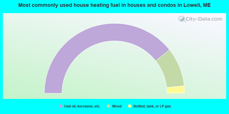
- 78.6%Fuel oil, kerosene, etc.
- 17.9%Wood
- 3.4%Bottled, tank, or LP gas
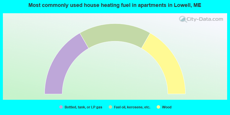
- 33.3%Bottled, tank, or LP gas
- 33.3%Fuel oil, kerosene, etc.
- 33.3%Wood
Lowell compared to Maine state average:
- Median house value below state average.
- Unemployed percentage below state average.
- Black race population percentage significantly below state average.
- Hispanic race population percentage significantly below state average.
- Median age significantly above state average.
- Foreign-born population percentage below state average.
- Renting percentage significantly below state average.
- Length of stay since moving in significantly above state average.
- Number of rooms per house significantly below state average.
- House age significantly below state average.
- Percentage of population with a bachelor's degree or higher below state average.