Lovell, Maine

Submit your own pictures of this town and show them to the world
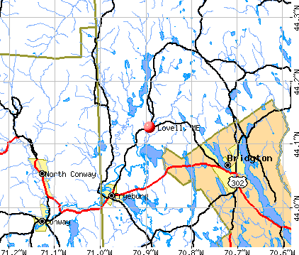
- OSM Map
- General Map
- Google Map
- MSN Map
Population change since 2000: +17.0%
 |
| Males: 555 | |
| Females: 585 |
| Median resident age: | 49.8 years |
| Maine median age: | 43.0 years |
Zip codes: 04051.
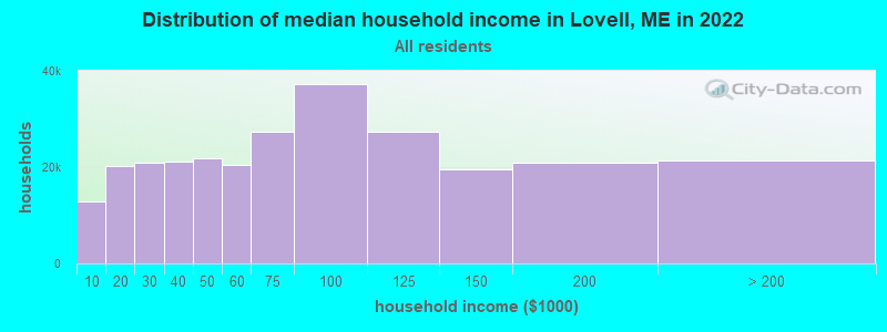
| Lovell: | $55,700 |
| ME: | $69,543 |
Estimated per capita income in 2022: $32,299 (it was $17,089 in 2000)
Lovell town income, earnings, and wages data
Estimated median house or condo value in 2022: $265,810 (it was $101,700 in 2000)
| Lovell: | $265,810 |
| ME: | $290,600 |
Mean prices in 2022: all housing units: $258,607; detached houses: $254,021; townhouses or other attached units: $393,466; in 2-unit structures: $184,786; in 3-to-4-unit structures: $229,715; in 5-or-more-unit structures: $205,553; mobile homes: $333,480; occupied boats, rvs, vans, etc.: $32,243
Detailed information about poverty and poor residents in Lovell, ME

Compare current foreclosures near Lovell, ME:
| Photo | Address | Area | Beds / Baths | Price | Details |
|---|---|---|---|---|---|

|
#1
Fein Ln
Center Conway, NH 03813
|
1,040 sq. feet
|
1 baths 3 beds |
show details | |

|
#2
Fein Lane A/k/a 26 Fein Lane
Center Conway, NH Array
|
952 sq. feet
|
1 baths 3 beds |
show details | |

|
#3
Henry Cotton Rd
Center Conway, NH 03813
|
1,792 sq. feet
|
2 baths 3 beds |
show details | |

|
#4
Bill Howe Rd
Norway, ME 04268
|
1,644 sq. feet
|
1 baths - beds |
show details | |

|
#5
Black Bear Rd
Fryeburg, ME 04037
|
1,296 sq. feet
|
- baths - beds |
show details | |

|
#6
Portland St
Fryeburg, ME 04037
|
600 sq. feet
|
- baths - beds |
show details | |

|
#7
Smith Ave # 1
Bridgton, ME 04009
|
- sq. feet
|
- baths - beds |
show details | |

|
#8
Colonial Cir
Harrison, ME 04040
|
- sq. feet
|
- baths - beds |
show details | |

|
#9
Fein Ln
Conway, NH 03818
|
- sq. feet
|
- baths - beds |
show details | |

|
#10
Blake Hill Rd
Center Conway, NH 03813
|
- sq. feet
|
- baths - beds |
show details |
| Photo | Address | Area | Beds / Baths | Price | Details |
|---|---|---|---|---|---|

|
Check over 1 million property listings on Foreclosure.com!
|
browse all offers | |||
| Photo | Address | Area | Beds / Baths | Price | Details |
|---|

- 1,10196.6%White alone
- 171.5%Two or more races
- 100.9%Hispanic
- 40.4%Black alone
- 40.4%Asian alone
- 30.3%American Indian alone
- 10.09%Native Hawaiian and Other
Pacific Islander alone
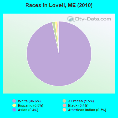
Races in Lovell detailed stats: ancestries, foreign born residents, place of birth
 Recent articles from our blog. Our writers, many of them Ph.D. graduates or candidates, create easy-to-read articles on a wide variety of topics.

 | SMALL HOUSES (year-round) (229 replies) |
| Looking for Suggestions Please (10 replies) |
| Western Maine: Dog socialization/play question (8 replies) |
| Moving to Andover Maine (10 replies) |
| New Name (wolfhelm) (5 replies) |
| Tax Friendly, Modern, Family-Sized, Reasonably Priced Homes (14 replies) |
Latest news from Lovell, ME collected exclusively by city-data.com from local newspapers, TV, and radio stations
Ancestries: English (32.1%), Irish (14.3%), United States (12.1%), French (9.4%), Scottish (5.9%), Italian (5.3%).
Current Local Time: EST time zone
Incorporated on 11/15/1800
Elevation: 407 feet
Land area: 43.2 square miles.
Population density: 26 people per square mile (very low).
20 residents are foreign born (0.9% Europe, 0.5% North America, 0.3% Asia, 0.3% Latin America).
| This town: | 2.1% |
| Maine: | 2.9% |
| Lovell town: | 1.1% ($1,118) |
| Maine: | 1.5% ($1,417) |
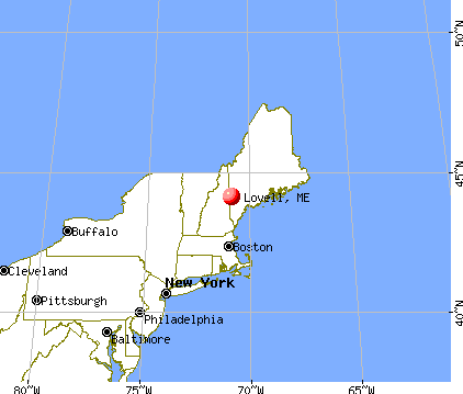
Nearest city with pop. 50,000+: Portland, ME  (47.6 miles , pop. 64,249).
Nearest city with pop. 200,000+: Boston, MA (129.3 miles , pop. 589,141).
Nearest city with pop. 1,000,000+: Bronx, NY (276.4 miles , pop. 1,332,650).
Nearest cities:
), Latitude: 44.19 N, Longitude: 70.89 W
Area code: 207

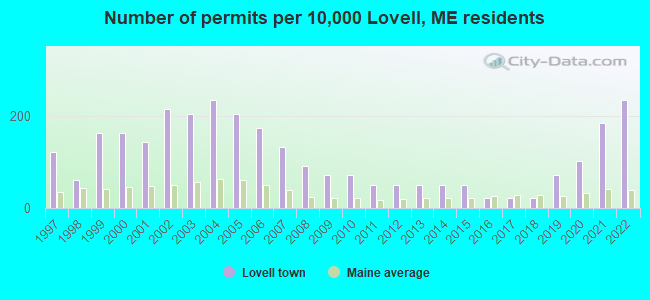
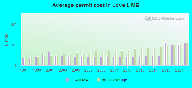
Single-family new house construction building permits:
- 2022: 23 buildings, average cost: $274,000
- 2021: 18 buildings, average cost: $259,200
- 2020: 10 buildings, average cost: $248,200
- 2019: 7 buildings, average cost: $282,200
- 2018: 2 buildings, average cost: $112,500
- 2017: 2 buildings, average cost: $112,500
- 2016: 2 buildings, average cost: $112,500
- 2015: 5 buildings, average cost: $107,800
- 2014: 5 buildings, average cost: $107,800
- 2013: 5 buildings, average cost: $107,800
- 2012: 5 buildings, average cost: $107,800
- 2011: 5 buildings, average cost: $107,800
- 2010: 7 buildings, average cost: $107,800
- 2009: 7 buildings, average cost: $107,800
- 2008: 9 buildings, average cost: $107,800
- 2007: 13 buildings, average cost: $107,800
- 2006: 17 buildings, average cost: $107,800
- 2005: 20 buildings, average cost: $107,800
- 2004: 23 buildings, average cost: $107,800
- 2003: 20 buildings, average cost: $117,200
- 2002: 21 buildings, average cost: $116,400
- 2001: 14 buildings, average cost: $164,900
- 2000: 16 buildings, average cost: $143,100
- 1999: 16 buildings, average cost: $102,200
- 1998: 6 buildings, average cost: $95,000
- 1997: 12 buildings, average cost: $90,400
| Here: | 2.6% |
| Maine: | 3.4% |
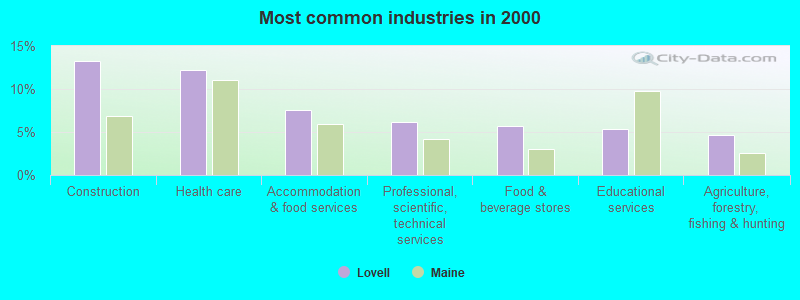
- Construction (13.3%)
- Health care (12.2%)
- Accommodation & food services (7.5%)
- Professional, scientific, technical services (6.2%)
- Food & beverage stores (5.8%)
- Educational services (5.3%)
- Agriculture, forestry, fishing & hunting (4.6%)
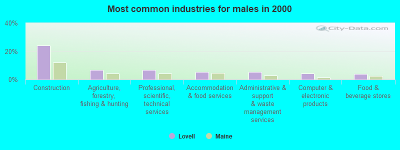
- Construction (24.0%)
- Agriculture, forestry, fishing & hunting (6.8%)
- Professional, scientific, technical services (6.8%)
- Accommodation & food services (5.2%)
- Administrative & support & waste management services (5.2%)
- Computer & electronic products (4.4%)
- Food & beverage stores (4.0%)
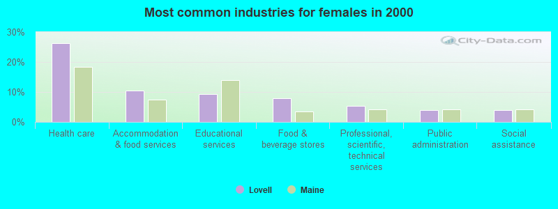
- Health care (26.2%)
- Accommodation & food services (10.4%)
- Educational services (9.4%)
- Food & beverage stores (7.9%)
- Professional, scientific, technical services (5.4%)
- Public administration (4.0%)
- Social assistance (4.0%)
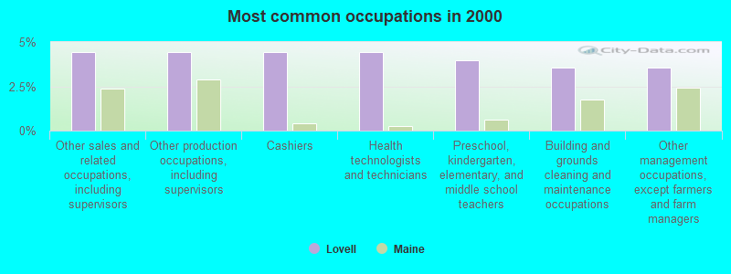
- Other sales and related occupations, including supervisors (4.4%)
- Other production occupations, including supervisors (4.4%)
- Cashiers (4.4%)
- Health technologists and technicians (4.4%)
- Preschool, kindergarten, elementary, and middle school teachers (4.0%)
- Building and grounds cleaning and maintenance occupations (3.5%)
- Other management occupations, except farmers and farm managers (3.5%)
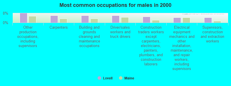
- Other production occupations, including supervisors (8.0%)
- Carpenters (6.0%)
- Building and grounds cleaning and maintenance occupations (6.0%)
- Driver/sales workers and truck drivers (6.0%)
- Construction traders workers except carpenters, electricians, painters, plumbers, and construction laborers (5.2%)
- Electrical equipment mechanics and other installation, maintenance, and repair workers, including supervisors (4.4%)
- Supervisors, construction and extraction workers (4.4%)
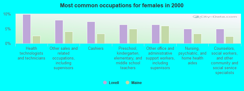
- Health technologists and technicians (9.9%)
- Other sales and related occupations, including supervisors (7.9%)
- Cashiers (7.4%)
- Preschool, kindergarten, elementary, and middle school teachers (6.4%)
- Other office and administrative support workers, including supervisors (6.4%)
- Nursing, psychiatric, and home health aides (5.0%)
- Counselors, social workers, and other community and social service specialists (5.0%)
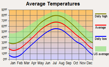
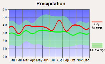
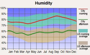
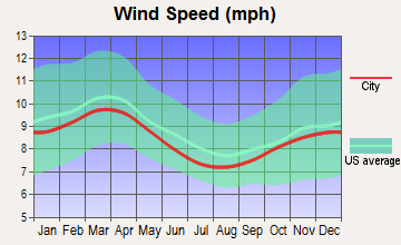
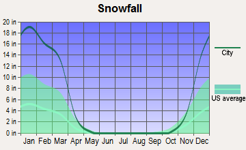
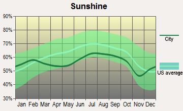
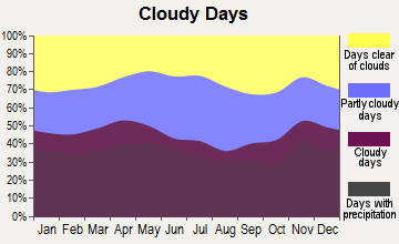
Average climate in Lovell, Maine
Based on data reported by over 4,000 weather stations
(lower is better)
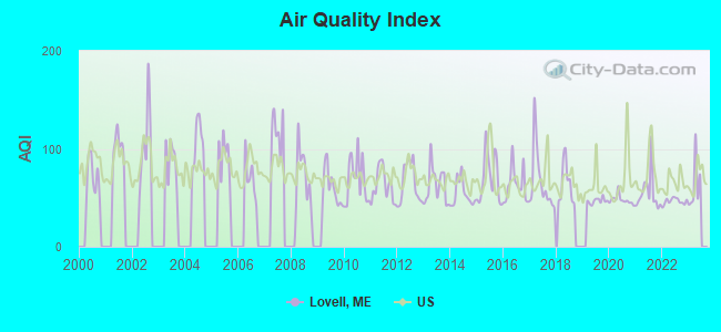
Air Quality Index (AQI) level in 2022 was 46.3. This is significantly better than average.
| City: | 46.3 |
| U.S.: | 72.6 |
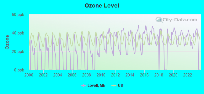
Ozone [ppb] level in 2022 was 33.8. This is about average. Closest monitor was 4.8 miles away from the city center.
| City: | 33.8 |
| U.S.: | 33.3 |
Tornado activity:
Lovell-area historical tornado activity is above Maine state average. It is 79% smaller than the overall U.S. average.
On 7/31/1971, a category F2 (max. wind speeds 113-157 mph) tornado 37.3 miles away from the Lovell town center injured one person and caused between $50,000 and $500,000 in damages.
On 7/31/1971, a category F2 tornado 38.0 miles away from the town center caused between $50,000 and $500,000 in damages.
Earthquake activity:
Lovell-area historical earthquake activity is significantly above Maine state average. It is 74% smaller than the overall U.S. average.On 4/20/2002 at 10:50:47, a magnitude 5.3 (5.3 ML, Depth: 3.0 mi, Class: Moderate, Intensity: VI - VII) earthquake occurred 140.5 miles away from Lovell center
On 4/20/2002 at 10:50:47, a magnitude 5.2 (5.2 MB, 4.2 MS, 5.2 MW, 5.0 MW) earthquake occurred 141.3 miles away from Lovell center
On 10/16/2012 at 23:12:25, a magnitude 4.7 (4.7 ML, Depth: 10.0 mi, Class: Light, Intensity: IV - V) earthquake occurred 42.4 miles away from the city center
On 10/7/1983 at 10:18:46, a magnitude 5.3 (5.1 MB, 5.3 LG, 5.1 ML) earthquake occurred 172.2 miles away from Lovell center
On 1/19/1982 at 00:14:42, a magnitude 4.7 (4.5 MB, 4.7 MD, 4.5 LG) earthquake occurred 59.1 miles away from the city center
On 8/21/1996 at 07:54:14, a magnitude 3.8 (3.8 LG, 3.6 LG, Depth: 6.2 mi, Class: Light, Intensity: II - III) earthquake occurred 22.8 miles away from the city center
Magnitude types: regional Lg-wave magnitude (LG), body-wave magnitude (MB), duration magnitude (MD), local magnitude (ML), surface-wave magnitude (MS), moment magnitude (MW)
Natural disasters:
The number of natural disasters in Oxford County (31) is a lot greater than the US average (15).Major Disasters (Presidential) Declared: 23
Emergencies Declared: 7
Causes of natural disasters: Floods: 19, Storms: 16, Snows: 7, Hurricanes: 3, Heavy Rains: 2, Blizzard: 1, Ice Storm: 1, Landslide: 1, Mudslide: 1, Snowfall: 1, Tropical Storm: 1, Wind: 1, Winter Storm: 1, Other: 2 (Note: some incidents may be assigned to more than one category).
Hospitals and medical centers near Lovell:
- FRYEBURG HEALTH CARE CENTER (Nursing Home, about 12 miles away; FRYEBURG, ME)
- HICKS NURSING HOME (Nursing Home, about 13 miles away; FRYEBURG, ME)
- BRIDGTON HEALTH CARE CENTER (Nursing Home, about 14 miles away; BRIDGTON, ME)
- VN AND HSP CARE SVC OF N CAR CTY (Home Health Center, about 15 miles away; NORTH CONWAY, NH)
Colleges/universities with over 2000 students nearest to Lovell:
- Saint Joseph's College of Maine (about 33 miles; Standish, ME; Full-time enrollment: 2,010)
- University of Southern Maine (about 48 miles; Portland, ME; FT enrollment: 6,647)
- Plymouth State University (about 50 miles; Plymouth, NH; FT enrollment: 4,838)
- University of Maine at Farmington (about 50 miles; Farmington, ME; FT enrollment: 2,036)
- Southern Maine Community College (about 50 miles; South Portland, ME; FT enrollment: 4,666)
- University of Maine at Augusta (about 56 miles; Augusta, ME; FT enrollment: 3,204)
- University of New England (about 57 miles; Biddeford, ME; FT enrollment: 4,539)
Public elementary/middle school in Lovell:
- NEW SUNCOOK SCHOOL (Location: 95 MAIN STREET, Grades: KG-5)
Libraries in Lovell:
- CHARLOTTE HOBBS MEMORIAL LIBRARY (Operating income: $93,008; Location: 227 MAIN STREET; 14,854 books; 674 audio materials; 1,661 video materials; 52 other licensed databases; 35 print serial subscriptions)
- LEWIS DANA HILL MEMORIAL LIBRARY (Operating income: $5,500; Location: 2079 MAIN STREET; 9,000 books; 300 audio materials; 175 video materials; 12 print serial subscriptions)
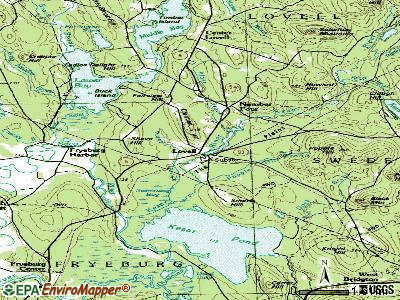
Points of interest:
Notable locations in Lovell: Camp Aqawam (A), Camp Mudiekewis (B), Lake Kezar Country Club (C), Kezar Lake Camp (D), Number Four (E), Lovell Volunteer Fire Department Village Station (F), Lovell Volunteer Fire Department Central Station (G), Lovell Volunteer Fire Department North Station (H). Display/hide their locations on the map
Church in Lovell: Lovell United Church of Christ (A). Display/hide its location on the map
Cemeteries: Village Cemetery (1), Fox Cemetery (2), Lord Cemetery (3), Stearns Cemetery (4). Display/hide their locations on the map
Lakes and reservoirs: Bradley Pond (A), Dan Charles Pond (B), Farrington Pond (C), Horseshoe Pond (D), Moose Pond (E), Mud Pond (F), Noah Eastman Pond (G), Heald Pond (H). Display/hide their locations on the map
Streams, rivers, and creeks: Mill Brook (A), Sucker Brook (B), Martin Brook (C), Long Meadow Brook (D), Little Trout Brook (E), Keyes Brook (F), Howard Brook (G), Great Brook (H), Cold Brook (I). Display/hide their locations on the map
Tourist attractions: Rocky Ridge Guide Service (Tours & Charters; 8 Ridge Road) (1), White Birch Guide Service & Kennel (Tours & Charters; Southern Maine Coast) (2). Display/hide their approximate locations on the map
Hotel: Quisisana Resort (Pleasant Point Road) (1). Display/hide its approximate location on the map
Birthplace of: Abraham Andrews Barker - Politician, Marcellus Stearns - Politician.
Drinking water stations with addresses in Lovell and their reported violations in the past:
EBENEZERS RESTAURANT & PUB (Population served: 210, Groundwater):Past health violations:N E FRONTIER CAMP (Population served: 100, Groundwater):Past monitoring violations:
- MCL, Monthly (TCR) - In JUN-2010, Contaminant: Coliform. Follow-up actions: St Public Notif requested (JUL-21-2010), St Formal NOV issued (JUL-21-2010), St Compliance achieved (AUG-31-2010)
- 5 routine major monitoring violations
- 2 regular monitoring violations
Past health violations:Past monitoring violations:
- MCL, Monthly (TCR) - In DEC-2011, Contaminant: Coliform. Follow-up actions: St Public Notif requested (JAN-03-2012), St Formal NOV issued (JAN-03-2012), St Compliance achieved (MAY-24-2013), St Site Visit (enforcement) (JUN-20-2013), St Public Notif received (JUN-20-2013)
- MCL, Monthly (TCR) - In OCT-2011, Contaminant: Coliform. Follow-up actions: St Public Notif requested (NOV-28-2011), St Formal NOV issued (NOV-28-2011), St Public Notif received (MAR-27-2012), St Compliance achieved (APR-05-2012)
- MCL, Monthly (TCR) - In AUG-2011, Contaminant: Coliform. Follow-up actions: St Public Notif requested (SEP-06-2011), St Formal NOV issued (SEP-06-2011), St Public Notif received (OCT-11-2011), St Compliance achieved (MAY-24-2013)
- One routine major monitoring violation
- 2 regular monitoring violations
| This town: | 2.4 people |
| Maine: | 2.3 people |
| This town: | 71.1% |
| Whole state: | 62.9% |
| This town: | 5.2% |
| Whole state: | 9.4% |
Likely homosexual households (counted as self-reported same-sex unmarried-partner households)
- Lesbian couples: 0.6% of all households
- Gay men: 0.4% of all households
| This town: | 12.4% |
| Whole state: | 10.9% |
| This town: | 5.0% |
| Whole state: | 4.1% |
For population 15 years and over in Lovell:
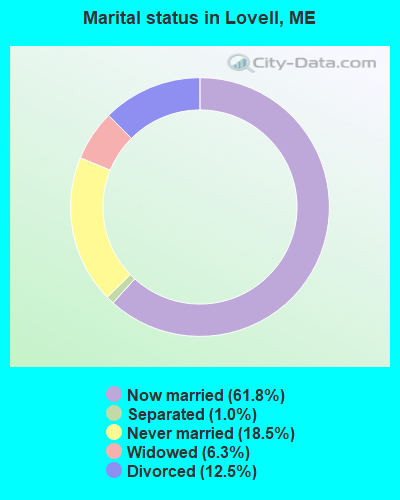
- Never married: 18.5%
- Now married: 61.8%
- Separated: 1.0%
- Widowed: 6.3%
- Divorced: 12.5%
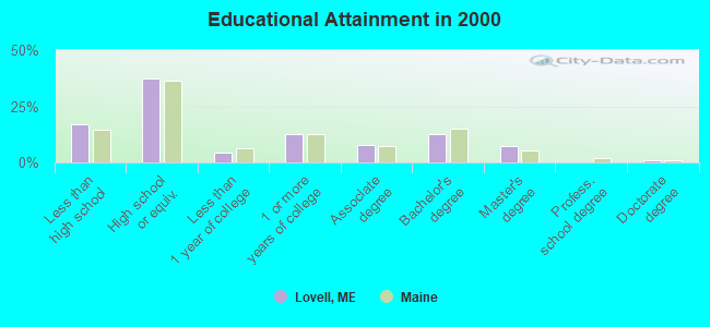
For population 25 years and over in Lovell:
- High school or higher: 83.1%
- Bachelor's degree or higher: 21.2%
- Graduate or professional degree: 8.3%
- Unemployed: 5.8%
- Mean travel time to work (commute): 34.1 minutes
| Here: | 11.4 |
| Maine average: | 11.2 |
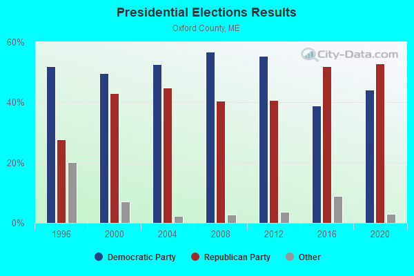
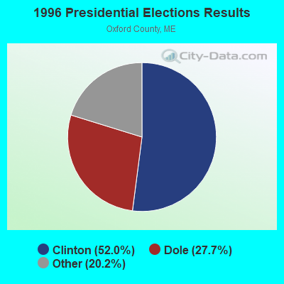
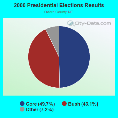
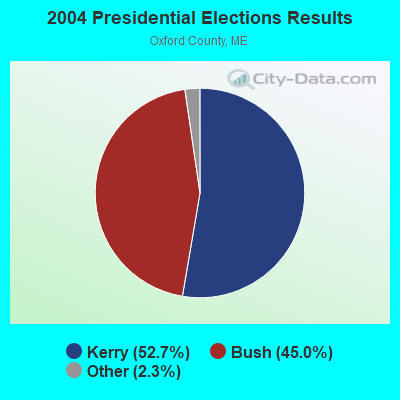
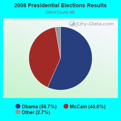

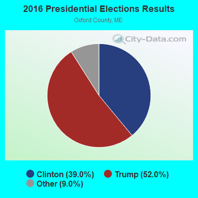
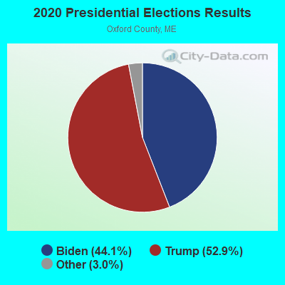
Graphs represent county-level data. Detailed 2008 Election Results
Religion statistics for Lovell, ME (based on Oxford County data)
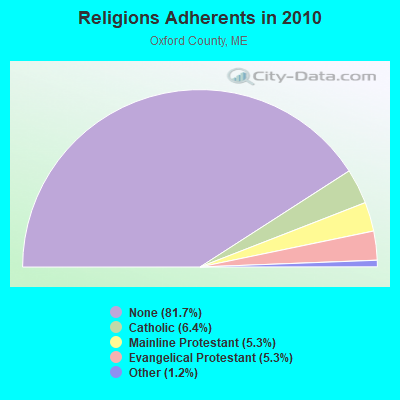
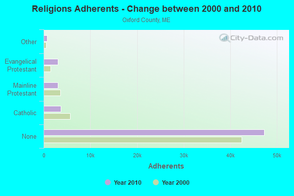
| Religion | Adherents | Congregations |
|---|---|---|
| Catholic | 3,708 | 7 |
| Mainline Protestant | 3,085 | 45 |
| Evangelical Protestant | 3,045 | 37 |
| Other | 719 | 14 |
| None | 47,276 | - |
Food Environment Statistics:
| Oxford County: | 2.47 / 10,000 pop. |
| Maine: | 2.80 / 10,000 pop. |
| Oxford County: | 0.35 / 10,000 pop. |
| Maine: | 0.14 / 10,000 pop. |
| Oxford County: | 2.29 / 10,000 pop. |
| Maine: | 2.20 / 10,000 pop. |
| Here: | 7.94 / 10,000 pop. |
| State: | 5.75 / 10,000 pop. |
| Oxford County: | 9.35 / 10,000 pop. |
| Maine: | 11.02 / 10,000 pop. |
| Oxford County: | 7.6% |
| State: | 8.2% |
| This county: | 25.6% |
| State: | 25.0% |
Businesses in Lovell, ME
- U-Haul: 1
Strongest AM radio stations in Lovell:
- WTME (780 AM; 10 kW; RUMFORD, ME; Owner: MOUNTAIN VALLEY BROADCASTING, INC.)
- WMTW (870 AM; 10 kW; GORHAM, ME; Owner: RADIO PARTNERS OF MAINE, L.P.)
- WRKO (680 AM; 50 kW; BOSTON, MA; Owner: ENTERCOM BOSTON LICENSE, LLC)
- WGAN (560 AM; 5 kW; PORTLAND, ME; Owner: SAGA COMMUNICATIONS OF NEW ENGLAND, LLC)
- WEEI (850 AM; 50 kW; BOSTON, MA; Owner: ENTERCOM BOSTON LICENSE, LLC)
- WLAM (1470 AM; 5 kW; LEWISTON, ME; Owner: RADIO PARTNERS OF MAINE, L.P.)
- WBNC (1050 AM; 1 kW; CONWAY, NH; Owner: MT. WASHINGTON RADIO & GRAMOPHONE, L.L.C.)
- WCRN (830 AM; 50 kW; WORCESTER, MA; Owner: CARTER BROADCASTING CORPORATION)
- WBZ (1030 AM; 50 kW; BOSTON, MA; Owner: INFINITY BROADCASTING OPERATIONS, INC.)
- WGIN (930 AM; 10 kW; ROCHESTER, NH; Owner: CAPSTAR TX LIMITED PARTNERSHIP)
- WNNZ (640 AM; 50 kW; WESTFIELD, MA; Owner: CLEAR CHANNEL BROADCASTING LICENSES, INC.)
- WCHP (760 AM; 35 kW; CHAMPLAIN, NY; Owner: CHAMPLAIN RADIO, INC.)
- WKOX (1200 AM; 50 kW; FRAMINGHAM, MA; Owner: CAPSTAR TX LIMITED PARTNERSHIP)
Strongest FM radio stations in Lovell:
- WPKQ (103.7 FM; NORTH CONWAY, NH; Owner: CITADEL BROADCASTING COMPANY)
- WHOM (94.9 FM; MT. WASHINGTON, NH; Owner: CITADEL BROADCASTING COMPANY)
- WMEA (90.1 FM; PORTLAND, ME; Owner: MAINE PUBLIC BROADCASTING CORPORATION)
- WSCY (106.9 FM; MOULTONBOROUGH, NH; Owner: NORTHEAST COMMUNICATIONS CORPORATION)
- WBLM (102.9 FM; PORTLAND, ME; Owner: CITADEL BROADCASTING COMPANY)
- WVFM (105.7 FM; CAMPTON, NH; Owner: DEVON BROADCASTING COMPANY, INC.)
- WLOB-FM (96.3 FM; RUMFORD, ME; Owner: ATLANTIC COAST RADIO, LLC)
- WTBM (100.7 FM; MEXICO, ME; Owner: MOUNTAIN VALLEY BROADCASTING, INC.)
- WTOS-FM (105.1 FM; SKOWHEGAN, ME; Owner: CAPSTAR TX LIMITED PARTNERSHIP)
- WGMT (97.7 FM; LYNDON, VT; Owner: VERMONT BROADCAST ASSOCIATES, INC.)
- WTHT (107.5 FM; LEWISTON, ME; Owner: RADIO PARTNERS OF MAINE, L.P.)
- WOXO-FM (92.7 FM; NORWAY, ME; Owner: TRI-COUNTY BROADCASTING, INC.)
- WMTK (106.3 FM; LITTLETON, NH; Owner: VERMONT BROADCAST ASSOCIATES, INC.)
- WMWV (93.5 FM; CONWAY, NH; Owner: MT. WASHINGTON RADIO & GRAMOPHONE, L.L.C.)
- WJBQ (97.9 FM; PORTLAND, ME; Owner: CITADEL BROADCASTING COMPANY)
- WVMJ (104.5 FM; CONWAY, NH; Owner: MT. WASHINGTON RADIO & GRAMOPHONE, L.L.C.)
- WXXS (102.3 FM; LANCASTER, NH; Owner: BARRY P. LUNDERVILLE)
- WMEK-FM (99.9 FM; AUBURN, ME; Owner: RADIO PARTNERS OF MAINE, L.P.)
TV broadcast stations around Lovell:
- WMTW-TV (Channel 8; POLAND SPRING, ME; Owner: WMTW BROADCAST GROUP, LLC)
- WGME-TV (Channel 13; PORTLAND, ME; Owner: WGME LICENSEE, LLC)
- WCSH (Channel 6; PORTLAND, ME; Owner: PACIFIC AND SOUTHERN COMPANY, INC.)
- WMEA-TV (Channel 26; BIDDEFORD, ME; Owner: MAINE PUBLIC BROADCASTING CORP.)
- WPXT (Channel 51; PORTLAND, ME; Owner: HMW, INC.)
- WPME (Channel 35; LEWISTON, ME; Owner: KB PRIME MEDIA LLC)
- W03AM (Channel 3; HARRISON, ETC., ME; Owner: MAINE PUBLIC BROADCASTING CORP.)
Lovell fatal accident list:
Jul 24, 2010 02:25 PM, Sr-5, Westway Road, Lat: 44.213403, Lon: -70.880097, Vehicles: 2, Persons: 4, Fatalities: 1
Aug 2, 2004 00:50 AM, Old Waterford Road, Vehicles: 1, Persons: 4, Fatalities: 1, Drunk persons involved: 1
Jul 1, 2002 03:30 PM, Sr-5, Vehicles: 2, Persons: 2, Fatalities: 1
- National Bridge Inventory (NBI) Statistics
- 2Number of bridges
- 16ft / 5.1mTotal length
- 1,817Total average daily traffic
- 90Total average daily truck traffic
- 2,762Total future (year 2036) average daily traffic
FCC Registered Amateur Radio Licenses:
13 (See the full list of FCC Registered Amateur Radio Licenses in Lovell)FAA Registered Aircraft:
2- Aircraft: GRUMMAN AMERICAN AVN. CORP. AA-5A (Category: Land, Seats: 4, Weight: Up to 12,499 Pounds, Speed: 105 mph), Engine: LYCOMING 0-320 SERIES (180 HP) (Reciprocating)
N-Number: 747SZ, N747SZ, N-747SZ, Serial Number: AA5A0515, Year manufactured: 1977, Airworthiness Date: 12/22/1977, Certificate Issue Date: 12/10/2020
Registrant (Individual): Glenn S Bender, 485 W Lovell Rd, Lovell, ME 04051 - Aircraft: RYAN NAVION A (Category: Land, Seats: 5, Weight: Up to 12,499 Pounds, Speed: 126 mph), Engine: CONT MOTOR TSIO 520SER (350 HP) (Reciprocating)
N-Number: 9TF, N9TF, N-9TF, Serial Number: NAV-4-1396, Year manufactured: 1948, Airworthiness Date: 08/12/2004, Certificate Issue Date: 07/22/2014
Registrant (Individual): Glenn Steven Bender, 485 W Lovell Rd, Lovell, ME 04051
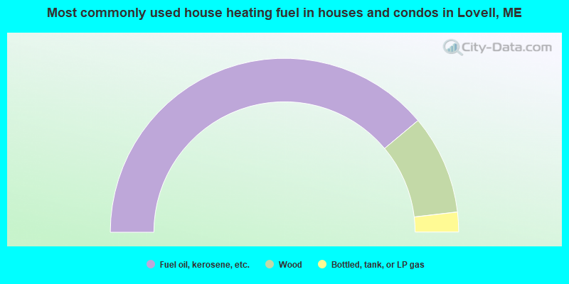
- 77.8%Fuel oil, kerosene, etc.
- 18.5%Wood
- 3.7%Bottled, tank, or LP gas
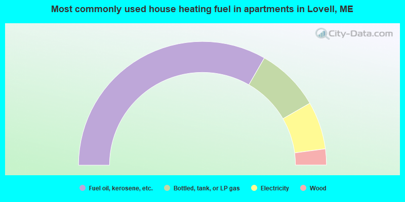
- 66.7%Fuel oil, kerosene, etc.
- 16.7%Bottled, tank, or LP gas
- 12.5%Electricity
- 4.2%Wood
Lovell compared to Maine state average:
- Unemployed percentage below state average.
- Black race population percentage significantly below state average.
- Hispanic race population percentage below state average.
- Median age above state average.
- Foreign-born population percentage below state average.
- Renting percentage significantly below state average.
- Length of stay since moving in significantly above state average.
- Number of rooms per house significantly below state average.
- House age significantly below state average.
- Number of college students below state average.