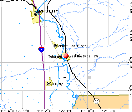
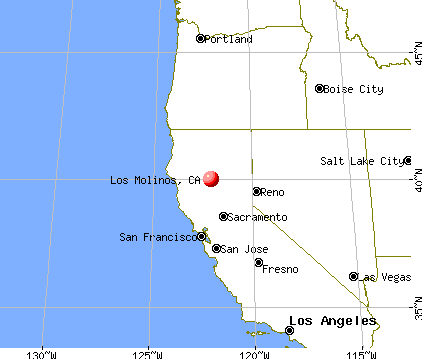
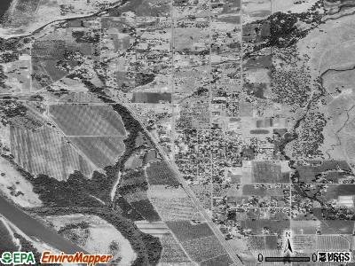
Los Molinos, California

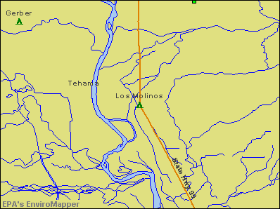
Los Molinos
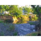
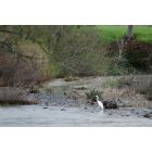
Los Molinos: Mill Creek Ca.
Los Molinos: Mill Creek near HWY 99E
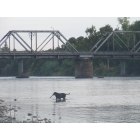
Los Molinos: Mill Creek Park and the RailRoad Bridge.
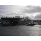
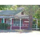
Los Molinos: Rob's Recycling in Los Molinos, California
Los Molinos: Rob's Recycling joined the Chamber in Los Molinos, California
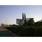
Los Molinos: Los Molinos Chamber of Commerce Office
- add
your
Submit your own pictures of this place and show them to the world
- OSM Map
- General Map
- Google Map
- MSN Map
Population change since 2000: +4.4%
| Males: 980 | |
| Females: 1,057 |
| Median resident age: | 35.5 years |
| California median age: | 37.9 years |
Zip codes: 96055.
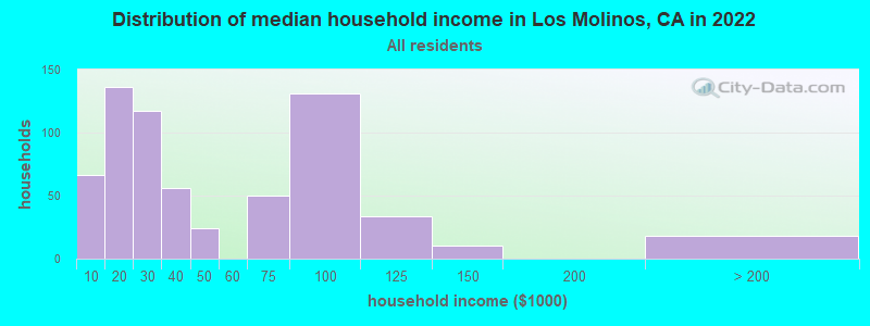
| Los Molinos: | $28,315 |
| CA: | $91,551 |
Estimated per capita income in 2022: $18,119 (it was $12,107 in 2000)
Los Molinos CDP income, earnings, and wages data
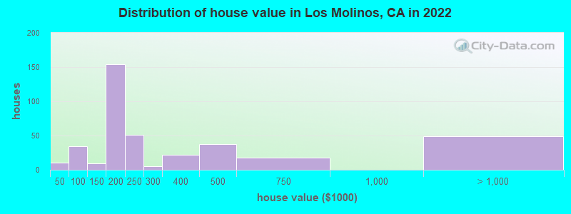
Estimated median house or condo value in 2022: $232,779 (it was $72,800 in 2000)
| Los Molinos: | $232,779 |
| CA: | $715,900 |
Mean prices in 2022: all housing units: $303,928; detached houses: $354,764; mobile homes: $167,716
Median gross rent in 2022: $1,166.
(33.7% for White Non-Hispanic residents, 42.9% for Hispanic or Latino residents, 41.9% for other race residents, 79.1% for two or more races residents)
Detailed information about poverty and poor residents in Los Molinos, CA

Compare current foreclosures near Los Molinos, CA:
| Photo | Address | Area | Beds / Baths | Price | Details |
|---|---|---|---|---|---|

|
#1
S Center St
Los Molinos, CA 96055
|
1,720 sq. feet
|
2 baths 3 beds |
show details | |

|
#2
Sherwood Blvd
Los Molinos, CA 96055
|
- sq. feet
|
2 baths 2 beds |
show details | |

|
#3
State Highway 99e
Los Molinos, CA 96055
|
- sq. feet
|
- baths - beds |
show details | |

|
#4
Buena Vista Ave
Los Molinos, CA 96055
|
- sq. feet
|
- baths - beds |
show details | |

|
#5
Foothill Blvd
Los Molinos, CA 96055
|
- sq. feet
|
- baths - beds |
show details | |

|
#6
Paskenta Rd
Corning, CA 96021
|
1,064 sq. feet
|
2 baths 2 beds |
$224,900
|
show details |

|
#7
Houghton Ave
Corning, CA 96021
|
- sq. feet
|
2 baths 2 beds |
show details | |

|
#8
Franzel Rd
Red Bluff, CA 96080
|
1,456 sq. feet
|
2 baths 3 beds |
show details | |

|
#9
Meadowbrook Ln
Corning, CA 96021
|
1,044 sq. feet
|
2 baths 3 beds |
show details | |

|
#10
Williams Ave
Red Bluff, CA 96080
|
1,591 sq. feet
|
2 baths 3 beds |
show details |
| Photo | Address | Area | Beds / Baths | Price | Details |
|---|---|---|---|---|---|

|
#11
E Fig Ln
Corning, CA 96021
|
1,974 sq. feet
|
2 baths 3 beds |
show details | |

|
#12
Lincoln St
Red Bluff, CA 96080
|
1,315 sq. feet
|
1 baths 2 beds |
show details | |

|
#13
Chestnut Ave
Red Bluff, CA 96080
|
2,042 sq. feet
|
2 baths 3 beds |
show details | |

|
#14
San Benito Ave
Gerber, CA 96035
|
864 sq. feet
|
1 baths 2 beds |
show details | |

|
#15
Krueger Ct
Red Bluff, CA 96080
|
2,166 sq. feet
|
3 baths 5 beds |
show details | |

|
#16
Walton Ave
Red Bluff, CA 96080
|
- sq. feet
|
2 baths 4 beds |
show details | |

|
#17
Mariposa Ave
Gerber, CA 96035
|
- sq. feet
|
3 baths 4 beds |
show details | |

|
#18
Reeds Creek Rd
Red Bluff, CA 96080
|
1,531 sq. feet
|
2 baths 3 beds |
show details | |

|
#19
Douglas St
Red Bluff, CA 96080
|
1,142 sq. feet
|
1 baths 3 beds |
show details | |

|
#20
Williams Ave
Red Bluff, CA 96080
|
1,591 sq. feet
|
2 baths 3 beds |
show details |
| Photo | Address | Area | Beds / Baths | Price | Details |
|---|---|---|---|---|---|

|
#21
Hunt Ave
Red Bluff, CA 96080
|
1,474 sq. feet
|
2 baths 2 beds |
show details | |

|
#22
Vallecito Way
Red Bluff, CA 96080
|
1,657 sq. feet
|
2 baths 3 beds |
show details | |

|
#23
Evelyn St
Red Bluff, CA 96080
|
1,064 sq. feet
|
2 baths 3 beds |
show details | |

|
#24
Cuesta Verde Ct
Red Bluff, CA 96080
|
2,646 sq. feet
|
2 baths 3 beds |
show details | |

|
#25
Wernmark Dr
Red Bluff, CA 96080
|
1,100 sq. feet
|
1 baths 3 beds |
show details | |

|
#26
Crosby Ln
Red Bluff, CA 96080
|
942 sq. feet
|
1 baths 2 beds |
show details | |

|
#27
Rowland Ln
Corning, CA 96021
|
2,298 sq. feet
|
2 baths 3 beds |
show details | |

|
#28
State Highway 99e # 99e
Red Bluff, CA 96080
|
1,308 sq. feet
|
2 baths 3 beds |
show details | |

|
#29
West St
Corning, CA 96021
|
1,975 sq. feet
|
2 baths 4 beds |
show details | |

|
#30
South St
Corning, CA 96021
|
1,956 sq. feet
|
2 baths 1 beds |
show details |
| Photo | Address | Area | Beds / Baths | Price | Details |
|---|---|---|---|---|---|

|
#31
North St
Corning, CA 96021
|
960 sq. feet
|
1 baths 2 beds |
show details | |

|
#32
Michigan Ave
Corning, CA 96021
|
1,560 sq. feet
|
2 baths 3 beds |
show details | |

|
#33
Colusa St
Corning, CA 96021
|
- sq. feet
|
- baths - beds |
show details | |

|
#34
Woodland Ave
Gerber, CA 96035
|
1,188 sq. feet
|
- baths - beds |
show details | |

|
#35
Mariposa Ave
Gerber, CA 96035
|
- sq. feet
|
- baths - beds |
show details | |

|
#36
San Benito Ave
Gerber, CA 96035
|
- sq. feet
|
- baths - beds |
show details | |

|
#37
Wilder Rd
Red Bluff, CA 96080
|
- sq. feet
|
- baths - beds |
show details | |

|
#38
E Solano St
Corning, CA 96021
|
- sq. feet
|
- baths - beds |
show details | |

|
#39
Flores Ave
Red Bluff, CA 96080
|
- sq. feet
|
- baths - beds |
show details | |

|
#40
Jackson St
Red Bluff, CA 96080
|
- sq. feet
|
- baths - beds |
show details |
| Photo | Address | Area | Beds / Baths | Price | Details |
|---|---|---|---|---|---|

|
#41
Kimball Rd Apt 208
Red Bluff, CA 96080
|
- sq. feet
|
- baths - beds |
show details | |

|
#42
Jackson St Apt 4
Red Bluff, CA 96080
|
- sq. feet
|
- baths - beds |
show details | |

|
#43
S Jackson St Apt 207
Red Bluff, CA 96080
|
- sq. feet
|
- baths - beds |
show details | |

|
#44
Cascade Ave
Red Bluff, CA 96080
|
- sq. feet
|
- baths - beds |
show details | |

|
#45
Blackberry Ave
Red Bluff, CA 96080
|
- sq. feet
|
- baths - beds |
show details | |

|
#46
S Main St Spc 44
Red Bluff, CA 96080
|
- sq. feet
|
- baths - beds |
show details | |

|
#47
Capay Rd
Corning, CA 96021
|
- sq. feet
|
- baths - beds |
show details | |

|
#48
Peach St
Corning, CA 96021
|
- sq. feet
|
- baths - beds |
show details | |

|
#49
Reeds Creek Rd
Red Bluff, CA 96080
|
- sq. feet
|
- baths - beds |
show details | |

|
Check over 1 million property listings on Foreclosure.com!
|
browse all offers | |||


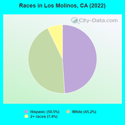
- 82950.5%Hispanic
- 74345.2%White alone
- 1227.4%Two or more races
According to our research of California and other state lists, there were 17 registered sex offenders living in Los Molinos, California as of May 09, 2024.
The ratio of all residents to sex offenders in Los Molinos is 124 to 1.
 Recent articles from our blog. Our writers, many of them Ph.D. graduates or candidates, create easy-to-read articles on a wide variety of topics.

 | California Wildfires Summer 2020 (191 replies) |
| RE: Relocation - What community do you recommend within 50 miles of Chico, CA? (15 replies) |
| Family of five looking to relocate to Northern California.. HELP! (27 replies) |
| where to buy whole walnuts (10 replies) |
| Cowboy Culture in CA? If so, where? (Ranching, Equine, Western life) (97 replies) |
| Moving to Chico, CA - Where to camp? (3 replies) |
Latest news from Los Molinos, CA collected exclusively by city-data.com from local newspapers, TV, and radio stations
Ancestries: American (11.6%), European (6.7%), English (4.8%), Italian (3.5%), Scottish (3.2%), Norwegian (2.9%).
Current Local Time: PST time zone
Elevation: 220 feet
Land area: 2.25 square miles.
Population density: 907 people per square mile (low).
140 residents are foreign born (8.5% Latin America).
| This place: | 8.5% |
| California: | 26.5% |
Median real estate property taxes paid for housing units with mortgages in 2022: $1,823 (0.7%)
Median real estate property taxes paid for housing units with no mortgage in 2022: $829 (0.4%)
Nearest city with pop. 50,000+: Chico, CA  (24.2 miles , pop. 59,954).
Nearest city with pop. 200,000+: Sacramento, CA (107.1 miles , pop. 407,018).
Nearest city with pop. 1,000,000+: Los Angeles, CA (459.2 miles , pop. 3,694,820).
Nearest cities:
), ), ), ), ), ), Latitude: 40.02 N, Longitude: 122.10 W
Area code: 530
| Here: | 6.4% |
| California: | 5.1% |
- Wood products (11.2%)
- Agriculture, forestry, fishing & hunting (10.4%)
- Accommodation & food services (8.4%)
- Administrative & support & waste management services (7.9%)
- Educational services (7.4%)
- Construction (5.9%)
- Department & other general merchandise stores (3.9%)
- Wood products (18.1%)
- Agriculture, forestry, fishing & hunting (16.5%)
- Construction (10.3%)
- Administrative & support & waste management services (7.8%)
- Accommodation & food services (6.5%)
- Utilities (5.9%)
- Repair & maintenance (5.4%)
- Educational services (15.6%)
- Accommodation & food services (10.9%)
- Health care (9.1%)
- Finance & insurance (8.0%)
- Administrative & support & waste management services (8.0%)
- Social assistance (7.6%)
- Food & beverage stores (4.7%)
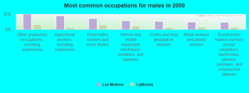
- Other production occupations, including supervisors (7.8%)
- Agricultural workers, including supervisors (7.1%)
- Driver/sales workers and truck drivers (5.0%)
- Laborers and material movers, hand (5.0%)
- Vehicle and mobile equipment mechanics, installers, and repairers (3.9%)
- Material recording, scheduling, dispatching, and distributing workers (3.9%)
- Cooks and food preparation workers (3.7%)
- Other production occupations, including supervisors (11.9%)
- Agricultural workers, including supervisors (10.8%)
- Driver/sales workers and truck drivers (8.6%)
- Vehicle and mobile equipment mechanics, installers, and repairers (6.8%)
- Cooks and food preparation workers (6.5%)
- Metal workers and plastic workers (5.9%)
- Construction traders workers except carpenters, electricians, painters, plumbers, and construction laborers (5.7%)
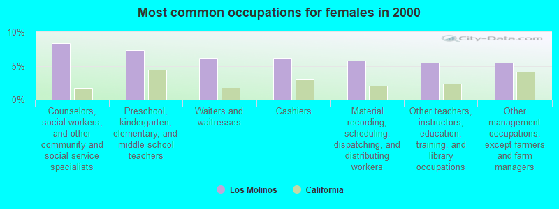
- Counselors, social workers, and other community and social service specialists (8.4%)
- Preschool, kindergarten, elementary, and middle school teachers (7.3%)
- Waiters and waitresses (6.2%)
- Cashiers (6.2%)
- Material recording, scheduling, dispatching, and distributing workers (5.8%)
- Other teachers, instructors, education, training, and library occupations (5.5%)
- Other management occupations, except farmers and farm managers (5.5%)
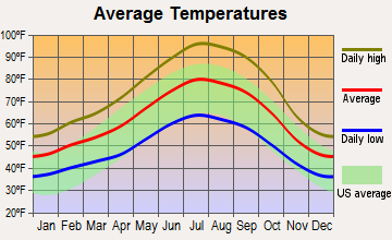
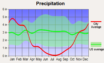
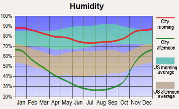
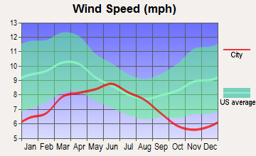
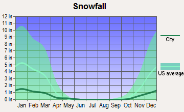
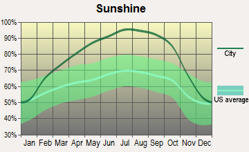
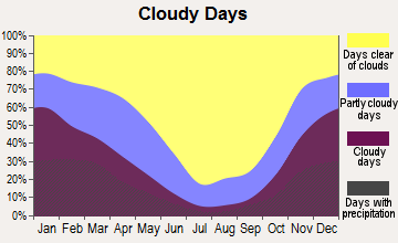
Average climate in Los Molinos, California
Based on data reported by over 4,000 weather stations
|
|

(lower is better)
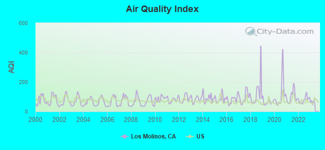
Air Quality Index (AQI) level in 2022 was 80.2. This is about average.
| City: | 80.2 |
| U.S.: | 72.6 |
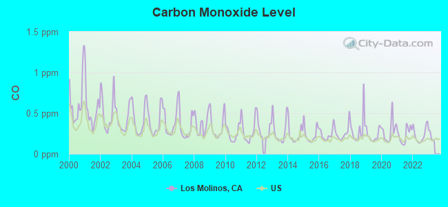
Carbon Monoxide (CO) [ppm] level in 2022 was 0.233. This is about average. Closest monitor was 13.1 miles away from the city center.
| City: | 0.233 |
| U.S.: | 0.251 |
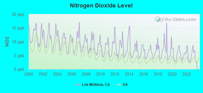
Nitrogen Dioxide (NO2) [ppb] level in 2022 was 5.46. This is about average. Closest monitor was 13.1 miles away from the city center.
| City: | 5.46 |
| U.S.: | 5.11 |
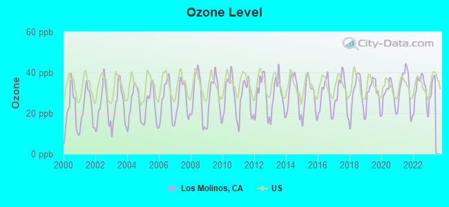
Ozone [ppb] level in 2022 was 31.3. This is about average. Closest monitor was 12.8 miles away from the city center.
| City: | 31.3 |
| U.S.: | 33.3 |
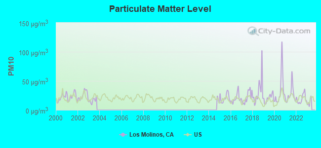
Particulate Matter (PM10) [µg/m3] level in 2022 was 19.2. This is about average. Closest monitor was 13.1 miles away from the city center.
| City: | 19.2 |
| U.S.: | 19.2 |
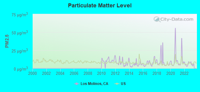
Particulate Matter (PM2.5) [µg/m3] level in 2022 was 6.34. This is better than average. Closest monitor was 12.0 miles away from the city center.
| City: | 6.34 |
| U.S.: | 8.11 |
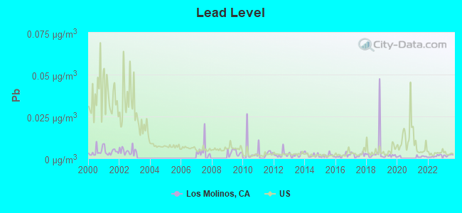
Lead (Pb) [µg/m3] level in 2023 was 0.00184. This is significantly better than average. Closest monitor was 13.1 miles away from the city center.
| City: | 0.00184 |
| U.S.: | 0.00931 |
Earthquake activity:
Los Molinos-area historical earthquake activity is significantly above California state average. It is 6118% greater than the overall U.S. average.On 4/18/1906 at 13:12:21, a magnitude 7.9 (7.9 UK, Class: Major, Intensity: VIII - XII) earthquake occurred 148.2 miles away from the city center, causing $524,000,000 total damage
On 1/31/1922 at 13:17:28, a magnitude 7.6 (7.6 UK) earthquake occurred 187.9 miles away from Los Molinos center
On 4/25/1992 at 18:06:04, a magnitude 7.2 (6.3 MB, 7.1 MS, 7.2 MW, 7.1 MW, Depth: 9.4 mi) earthquake occurred 106.4 miles away from Los Molinos center, causing $75,000,000 total damage
On 11/8/1980 at 10:27:34, a magnitude 7.2 (6.2 MB, 7.2 MS, 7.2 MW, 7.0 ML) earthquake occurred 137.9 miles away from the city center
On 10/3/1915 at 06:52:48, a magnitude 7.6 (7.6 UK) earthquake occurred 245.0 miles away from Los Molinos center
On 1/22/1923 at 09:04:18, a magnitude 7.2 (7.2 UK) earthquake occurred 173.2 miles away from Los Molinos center
Magnitude types: body-wave magnitude (MB), local magnitude (ML), surface-wave magnitude (MS), moment magnitude (MW)
Natural disasters:
The number of natural disasters in Tehama County (19) is greater than the US average (15).Major Disasters (Presidential) Declared: 12
Emergencies Declared: 3
Causes of natural disasters: Floods: 13, Storms: 7, Winter Storms: 6, Landslides: 4, Fires: 2, Mudslides: 2, Drought: 1, Freeze: 1, Heavy Rain: 1, Hurricane: 1, Tornado: 1, Other: 1 (Note: some incidents may be assigned to more than one category).

Hospitals and medical centers near Los Molinos:
- ACCENTCARE HOME HEALTH OF CALIFORNIA, INC (Home Health Center, about 8 miles away; CORNING, CA)
- RED BLUFF DIALYSIS (Dialysis Facility, about 11 miles away; RED BLUFF, CA)
- ST ELIZABETH COMMUNITY HOSPITAL Acute Care Hospitals (about 11 miles away; RED BLUFF, CA)
- RED BLUFF HEALTH CARE CENTER (Nursing Home, about 12 miles away; RED BLUFF, CA)
- BRENTWOOD SKILLED NURSING (Nursing Home, about 13 miles away; RED BLUFF, CA)
- ADDUS HEALTHCARE, INC (Home Health Center, about 14 miles away; RED BLUFF, CA)
Colleges/universities with over 2000 students nearest to Los Molinos:
- California State University-Chico (about 25 miles; Chico, CA; Full-time enrollment: 14,838)
- Butte College (about 36 miles; Oroville, CA; FT enrollment: 8,649)
- Shasta College (about 44 miles; Redding, CA; FT enrollment: 5,645)
- Yuba College (about 69 miles; Marysville, CA; FT enrollment: 4,737)
- Mendocino College (about 84 miles; Ukiah, CA; FT enrollment: 2,263)
- Sierra College (about 98 miles; Rocklin, CA; FT enrollment: 11,488)
- Universal Technical Institute of Northern California Inc (about 101 miles; Sacramento, CA; FT enrollment: 3,193)
Public high schools in Los Molinos:
- LOS MOLINOS HIGH (Students: 132, Location: 7900 SHERWOOD BLVD., Grades: 9-12)
- LOS MOLINOS COMMUNITY DAY (Students: 5, Location: 25330 MAGNOLIA ST., Grades: 6-12)
Public elementary/middle schools in Los Molinos:
- LASSEN VIEW ELEMENTARY (Students: 209, Location: 10818 HIGHWAY 99-E, Grades: KG-8)
- LOS MOLINOS ELEMENTARY (Students: 179, Location: 7700 STANFORD, Grades: KG-8)
- LASSEN VIEW COMMUNITY DAY (Students: 8, Location: 10818 HIGHWAY 99-E, Grades: KG-8)
Points of interest:
Notable location: Tehama County Fire Department Station 10 Los Molinos (A). Display/hide its location on the map
Creek: Mill Creek (A). Display/hide its location on the map
Park in Los Molinos: Mill Creek Park (1). Display/hide its location on the map
Birthplace of: Marv Grissom - Baseball player and coach.
Drinking water stations with addresses in Los Molinos and their reported violations in the past:
ANTELOPE CREEK MHP (Population served: 75, Groundwater):Past monitoring violations:
- One minor monitoring violation
- 16 regular monitoring violations
Drinking water stations with addresses in Los Molinos that have no violations reported:
- HIDDEN HARBOR MARINA & RVP (Population served: 100, Primary Water Source Type: Groundwater)
| This place: | 2.5 people |
| California: | 2.9 people |
| This place: | 63.2% |
| Whole state: | 68.7% |
| This place: | 9.0% |
| Whole state: | 7.2% |
Likely homosexual households (counted as self-reported same-sex unmarried-partner households)
- Lesbian couples: 0.1% of all households
- Gay men: 0.0% of all households
People in group quarters in Los Molinos in 2000:
- 22 people in other noninstitutional group quarters
- 8 people in nursing homes
- 4 people in homes for the mentally retarded
Banks with branches in Los Molinos (2011 data):
- Umpqua Bank: Los Molinos Branch at 7843 Highway 99e, branch established on 1985/10/28. Info updated 2011/09/02: Bank assets: $11,556.7 mil, Deposits: $9,325.3 mil, headquarters in Roseburg, OR, positive income, Commercial Lending Specialization, 193 total offices, Holding Company: Umpqua Holdings Corporation
For population 15 years and over in Los Molinos:
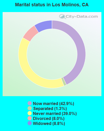
- Never married: 39.0%
- Now married: 42.9%
- Separated: 1.3%
- Widowed: 8.8%
- Divorced: 8.0%
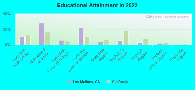
For population 25 years and over in Los Molinos:
- High school or higher: 90.2%
- Bachelor's degree or higher: 14.2%
- Graduate or professional degree: 5.6%
- Unemployed: 12.8%
- Mean travel time to work (commute): 42.1 minutes
| Here: | 11.6 |
| California average: | 15.5 |
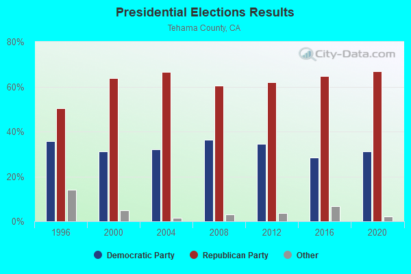
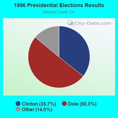

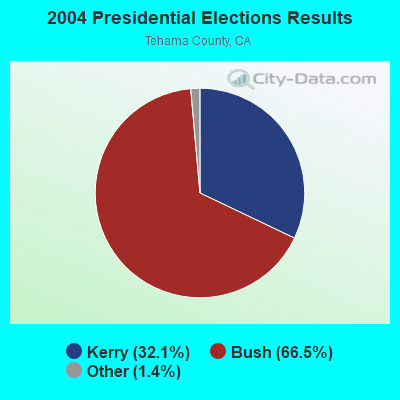
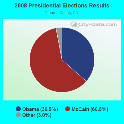
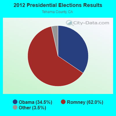
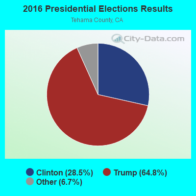

Graphs represent county-level data. Detailed 2008 Election Results
Religion statistics for Los Molinos, CA (based on Tehama County data)
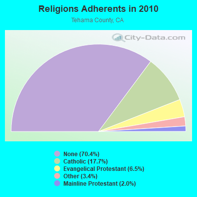
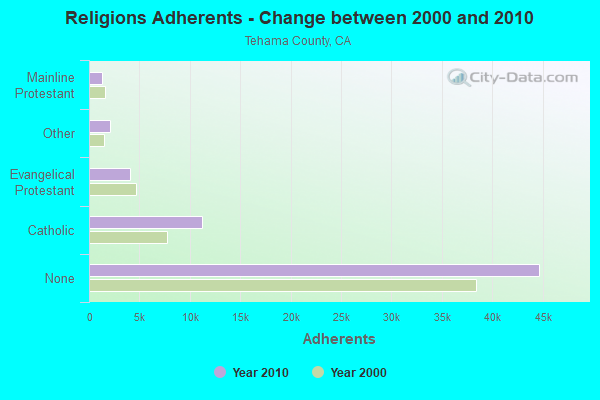
| Religion | Adherents | Congregations |
|---|---|---|
| Catholic | 11,243 | 3 |
| Evangelical Protestant | 4,100 | 39 |
| Other | 2,130 | 6 |
| Mainline Protestant | 1,280 | 11 |
| Orthodox | 20 | 1 |
| None | 44,690 | - |
Food Environment Statistics:
| Tehama County: | 1.80 / 10,000 pop. |
| State: | 2.14 / 10,000 pop. |
| Here: | 0.98 / 10,000 pop. |
| State: | 0.62 / 10,000 pop. |
| This county: | 3.12 / 10,000 pop. |
| State: | 1.49 / 10,000 pop. |
| Tehama County: | 4.76 / 10,000 pop. |
| California: | 7.42 / 10,000 pop. |
| Tehama County: | 8.4% |
| California: | 7.3% |
| Tehama County: | 25.5% |
| California: | 21.3% |
| This county: | 13.3% |
| California: | 17.9% |
Health and Nutrition:
| Los Molinos: | 51.1% |
| California: | 49.4% |
| Los Molinos: | 48.2% |
| California: | 48.0% |
| Los Molinos: | 28.2 |
| California: | 28.1 |
| This city: | 20.7% |
| California: | 20.2% |
| Here: | 9.1% |
| State: | 11.2% |
| Los Molinos: | 6.9 |
| State: | 6.8 |
| This city: | 33.8% |
| California: | 31.5% |
| This city: | 56.4% |
| California: | 56.4% |
| Los Molinos: | 78.2% |
| California: | 80.9% |
More about Health and Nutrition of Los Molinos, CA Residents
Businesses in Los Molinos, CA
- Ace Hardware: 1
- FedEx: 1
- U-Haul: 1
Strongest AM radio stations in Los Molinos:
- KPAY (1290 AM; 5 kW; CHICO, CA; Owner: CAPSTAR TX LIMITED PARTNERSHIP)
- KFBK (1530 AM; 50 kW; SACRAMENTO, CA; Owner: AMFM RADIO LICENSES, L.L.C.)
- KNRO (1670 AM; 10 kW; REDDING, CA; Owner: REGENT LICENSEE OF REDDING, INC.)
- KBLF (1490 AM; 1 kW; RED BLUFF, CA; Owner: TOM HUTH)
- KKOH (780 AM; 50 kW; RENO, NV; Owner: CITADEL BROADCASTING COMPANY)
- KFIA (710 AM; 25 kW; CARMICHAEL, CA; Owner: VISTA BROADCASTING INC.)
- KCBS (740 AM; 50 kW; SAN FRANCISCO, CA; Owner: INFINITY BROADCASTING OPERATIONS, INC.)
- KHTK (1140 AM; 50 kW; SACRAMENTO, CA; Owner: INFINITY RADIO SUBSIDIARY OPERATIONS INC.)
- KSTE (650 AM; 25 kW; RANCHO CORDOVA, CA; Owner: AMFM RADIO LICENSES, L.L.C.)
- KTRB (860 AM; 50 kW; MODESTO, CA; Owner: PAPPAS RADIO OF CALIFORNIA, A CALIFORNIA LIMITED PARTNERSHIP)
- KNBR (680 AM; 50 kW; SAN FRANCISCO, CA; Owner: KNBR LICO, INC.)
- KVIP (540 AM; 2 kW; REDDING, CA; Owner: PACIFIC CASCADE COMMUNICATIONS CORP.)
- KCBC (770 AM; 50 kW; RIVERBANK, CA; Owner: KIERTRON, INC.)
Strongest FM radio stations in Los Molinos:
- KLVB-FM (102.7 FM; RED BLUFF, CA; Owner: EDUCATIONAL MEDIA FOUNDATION)
- KLVC (88.3 FM; MAGALIA, CA; Owner: EDUCATIONAL MEDIA FOUNDATION)
- K216CF (91.1 FM; CHICO, CA; Owner: YOUR CHRISTIAN COMPANION NETWORK, INC.)
- KZAP (96.7 FM; PARADISE, CA; Owner: REGENT LICENSEE OF CHICO, INC.)
- KHSL-FM (103.5 FM; PARADISE, CA; Owner: CAPSTAR TX LIMITED PARTNERSHIP)
- KCHO (91.7 FM; CHICO, CA; Owner: UNIV. FOUNDATION/CA. ST. UNIV. CHICO)
- KRDG (105.3 FM; SHINGLETOWN, CA; Owner: REGENT LICENSEE OF REDDING, INC.)
- KMXI (95.1 FM; CHICO, CA; Owner: CAPSTAR TX LIMITED PARTNERSHIP)
- KHRD (103.1 FM; WEAVERVILLE, CA; Owner: RESULTS RADIO LICENSEE, LLC)
- KFMF (93.9 FM; CHICO, CA; Owner: REGENT LICENSEE OF CHICO, INC)
- KNCQ (97.3 FM; REDDING, CA; Owner: RESULTS RADIO OF REDDING, LLC)
- KTHU (100.7 FM; CORNING, CA; Owner: RESULTS RADIO LICENSEE, LLC)
- K225AJ (92.9 FM; BURNEY/REDDING, CA; Owner: CALVARY CHAPEL OF TWIN FALLS, INC.)
- KALF (95.7 FM; RED BLUFF, CA; Owner: REGENT LICENSEE OF CHICO, INC)
- K205EJ (88.9 FM; CHESTER, CA; Owner: CALVARY CHAPEL OF TWIN FALLS, INC.)
- KKXS (96.1 FM; SHINGLETOWN, CA; Owner: RESULTS RADIO LICENSEE, LLC)
- KYIX (104.9 FM; SOUTH OROVILLE, CA; Owner: BUTTE BROADCASTING COMPANY, INC.)
- KTOR (99.7 FM; WESTWOOD, CA; Owner: SIERRA RADIO, INC.)
- KHGQ (100.3 FM; QUINCY, CA; Owner: KEILY MILLER)
- KBNF (98.9 FM; CHESTER, CA; Owner: CAROUSEL BROADCASTING, INC.)
TV broadcast stations around Los Molinos:
- KNVN (Channel 24; CHICO, CA; Owner: CHICO LICENSE, L.L.C.)
- KCVU (Channel 30; PARADISE, CA; Owner: SAINTE PARTNERS II, L.P.)
- K53FT (Channel 53; CHICO, CA; Owner: TRINITY BROADCASTING NETWORK)
Los Molinos fatal accident list:
Dec 17, 2018 09:49 PM, Tehama And Vina Rd, Lat: 40.031311, Lon: -122.100433, Vehicles: 1, Persons: 1, Pedestrians: 1, Fatalities: 1, Drunk persons involved: 1
Jun 18, 2017 04:20 AM, Sr-99, Lat: 40.022856, Lon: -122.099825, Vehicles: 1, Persons: 1, Fatalities: 1
Jul 24, 2013 01:18 PM, Sr-99, Sherman St, Lat: 40.012033, Lon: -122.095456, Vehicles: 3, Persons: 4, Fatalities: 1
Oct 30, 2010 02:00 AM, Sr-99, Rose St, Lat: 40.020119, Lon: -122.099597, Vehicles: 2, Persons: 1, Fatalities: 1, Drunk persons involved: 1
- National Bridge Inventory (NBI) Statistics
- 19Number of bridges
- 151ft / 45.6mTotal length
- $674,000Total costs
- 67,420Total average daily traffic
- 8,378Total average daily truck traffic
- 75,588Total future (year 2040) average daily traffic
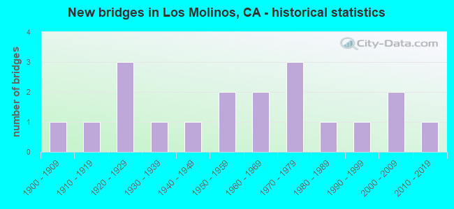
- New bridges - historical statistics
- 11900-1909
- 11910-1919
- 31920-1929
- 11930-1939
- 11940-1949
- 21950-1959
- 21960-1969
- 31970-1979
- 11980-1989
- 11990-1999
- 22000-2009
- 12010-2019
FCC Registered Antenna Towers:
2- Douglas I Brandon, 25025 Aramayo Way (Lat: 40.027222 Lon: -122.103056), Type: 31.7, Overall height: 31.7 m, Registrant: At&t Wireless Services, Inc., Esther.Hilliard@attws.Com, , Washi-ngton, Phone: (202) 223-9222
- Douglas I Brandon, 25025 Aramayo Way (Lat: 40.027222 Lon: -122.103056), Type: 31.7, Overall height: 31.7 m, Registrant: At&t Wireless Services, Inc., Esther.Hilliard@attws.Com, , Washi-ngton, Phone: (202) 223-9222
FCC Registered Broadcast Land Mobile Towers:
6- LOSMOLNOSTEHFS, 7930 Sherwood Blvd (Lat: 40.026694 Lon: -122.095833), Type: Building, Structure height: 8 m, Overall height: 9 m, Call Sign: WPJI318,
Assigned Frequencies: 151.370 MHz, 159.285 MHz, Grant Date: 03/31/2021, Expiration Date: 06/25/2031, Certifier: Glen S Nash, Registrant: State Of California, 601 Sequoia Pacific Blvd, Sacramento, CA 95811-0231, Phone: (916) 894-5102, Fax: (916) 894-5392, Email:
- Tehama Bridge Telemetry 2 Km Nw (Lat: 40.028500 Lon: -122.118333), Type: Pipe, Structure height: 5 m, Overall height: 6 m, Call Sign: WCC917, Licensee ID: L00009514,
Assigned Frequencies: 169.500 MHz, Grant Date: 05/25/2005, Expiration Date: 07/05/2015, Cancellation Date: 01/05/2012, Certifier: Glen S Nash, Registrant: State Of California, 601 Sequoia Pacific Blvd, Sacramento, CA 95811-0231, Phone: (916) 657-6153, Fax: (916) 657-9468, Email:
- 1/4 Mi W Of Hwy 99e On 63rd Ave (Lat: 40.096000 Lon: -122.103333), Call Sign: KRM585,
Assigned Frequencies: 43.0000 MHz, Grant Date: 04/06/2000, Expiration Date: 05/17/2005, Cancellation Date: 07/23/2005, Registrant: Lindauer River Ranch, 11790 Tyler Rd, Red Bluff, CA 96080, Phone: (916) 527-6795
- Lat: 40.024583 Lon: -122.098722, Call Sign: WPWV974,
Assigned Frequencies: 462.300 MHz, Grant Date: 01/28/2003, Expiration Date: 01/28/2013, Cancellation Date: 03/30/2013, Certifier: Donald Pike, Registrant: Radio Licensing Services, P.O. Box 22161, Milwaukie, OR 97222, Phone: (503) 794-3761, Fax: (503) 794-3759
- Lat: 40.107722 Lon: -122.110056, Call Sign: WQUV251,
Assigned Frequencies: 461.475 MHz, 466.475 MHz, Grant Date: 10/22/2014, Expiration Date: 10/22/2024, Certifier: Heather Igarta, Registrant: Valley Industrial Communications, 5040 Caterpillar Rd, Redding, CA 96003, Phone: (530) 241-6025, Email:
- Dye Creek Canyon 10km Ne Of Los Molinos (Lat: 40.105639 Lon: -122.024306), Type: Pipe, Structure height: 1.5 m, Overall height: 4 m, Call Sign: WRCG574,
Assigned Frequencies: 464.237 MHz, Grant Date: 09/25/2018, Expiration Date: 09/25/2028, Certifier: Scott Hardage, Registrant: The Nature Conservancy, 26855 Foothill Rd., Los Molinos, CA 96055, Phone: (530) 727-5751, Email:
FCC Registered Microwave Towers:
3- LOS MOLINOS, 25195 4th Ave (Lat: 40.066667 Lon: -122.100056), Type: Ltower, Structure height: 33.5 m, Overall height: 35.1 m, Call Sign: WRBS389,
Assigned Frequencies: 11405.0 MHz, 11405.0 MHz, 11405.0 MHz, 11405.0 MHz, 11405.0 MHz, 11405.0 MHz, 11405.0 MHz, 11405.0 MHz, Grant Date: 06/05/2018, Expiration Date: 06/05/2028, Certifier: Scott M Schifando, Registrant: Micronet Communications, Inc., 812 Lexington Dr, Plano, TX 75075, Phone: (972) 422-7200, Email:
- Los Molinos, 25031 Aramayo Way (Lat: 40.027083 Lon: -122.103139), Type: Mtower, Structure height: 30.5 m, Overall height: 33.5 m, Call Sign: WRXR860,
Assigned Frequencies: 11645.0 MHz, 11645.0 MHz, 11645.0 MHz, 11645.0 MHz, 11645.0 MHz, 11645.0 MHz, 11645.0 MHz, 11645.0 MHz, 11645.0 MHz, 11645.0 MHz... (+10 more), Grant Date: 06/22/2023, Expiration Date: 06/22/2033, Certifier: Peter L Sorensen, Registrant: Micronet Communications, Inc., 812 Lexington Dr, Plano, TX 75075, Phone: (972) 422-7200, Email:
- lsmsca01, 25025 Aramayo Way (Lat: 40.027111 Lon: -122.103139), Type: Gtower, Structure height: 48.8 m, Call Sign: WSAR396,
Assigned Frequencies: 11325.0 MHz, 11485.0 MHz, 11325.0 MHz, 11485.0 MHz, 11325.0 MHz, 11485.0 MHz, 11325.0 MHz, 11485.0 MHz, 11325.0 MHz, 11485.0 MHz... (+10 more), Grant Date: 02/06/2024, Expiration Date: 02/06/2034, Certifier: Josh Rogers, Registrant: Micronet Communications, Inc., 812 Lexington Dr, Plano, TX 75075, Phone: (972) 422-7200, Email:
FCC Registered Amateur Radio Licenses:
28 (See the full list of FCC Registered Amateur Radio Licenses in Los Molinos)| Most common first names in Los Molinos, CA among deceased individuals | ||
| Name | Count | Lived (average) |
|---|---|---|
| John | 43 | 75.8 years |
| Robert | 34 | 71.1 years |
| William | 32 | 78.9 years |
| George | 27 | 80.2 years |
| James | 25 | 75.2 years |
| Mary | 21 | 78.9 years |
| Frank | 14 | 79.3 years |
| Richard | 13 | 68.2 years |
| Helen | 13 | 79.9 years |
| Ruth | 13 | 75.0 years |
| Most common last names in Los Molinos, CA among deceased individuals | ||
| Last name | Count | Lived (average) |
|---|---|---|
| Brown | 15 | 79.7 years |
| Anderson | 14 | 81.1 years |
| Smith | 13 | 82.4 years |
| Thompson | 13 | 77.6 years |
| Johnson | 12 | 77.0 years |
| Jones | 7 | 66.6 years |
| Day | 7 | 76.0 years |
| Nagos | 7 | 75.4 years |
| Wilson | 6 | 76.0 years |
| Mattoon | 6 | 87.5 years |
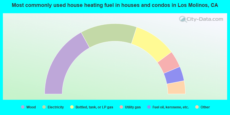
- 34.3%Wood
- 26.2%Electricity
- 19.8%Bottled, tank, or LP gas
- 7.7%Utility gas
- 6.7%Fuel oil, kerosene, etc.
- 3.0%Solar energy
- 2.5%Other fuel
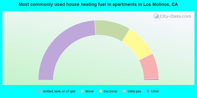
- 48.3%Bottled, tank, or LP gas
- 19.6%Wood
- 18.2%Electricity
- 14.0%Utility gas
Los Molinos compared to California state average:
- Median household income significantly below state average.
- Median house value significantly below state average.
- Black race population percentage significantly below state average.
- Median age significantly above state average.
- Foreign-born population percentage significantly below state average.
- House age above state average.
- Percentage of population with a bachelor's degree or higher below state average.