Liberty, Maine

Liberty: Cabin on St. Georges Lake at route 3, near 173
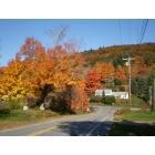
Liberty: Haystack Mountain from Rte.220 (Main St is crossroad)
- add
your
Submit your own pictures of this town and show them to the world
- OSM Map
- General Map
- Google Map
- MSN Map

Population change since 2000: -1.5%
 |
| Males: 470 | |
| Females: 443 |
| Median resident age: | 47.2 years |
| Maine median age: | 43.0 years |
Zip codes: 04949.
| Liberty: | $65,003 |
| ME: | $69,543 |
Estimated per capita income in 2022: $34,373 (it was $16,201 in 2000)
Liberty town income, earnings, and wages data
Estimated median house or condo value in 2022: $250,878 (it was $85,900 in 2000)
| Liberty: | $250,878 |
| ME: | $290,600 |
Mean prices in 2022: all housing units: $270,070; detached houses: $293,055; townhouses or other attached units: $325,130; in 2-unit structures: $297,158; in 3-to-4-unit structures: $211,194; in 5-or-more-unit structures: $284,526; mobile homes: $128,233; occupied boats, rvs, vans, etc.: $21,180
Detailed information about poverty and poor residents in Liberty, ME


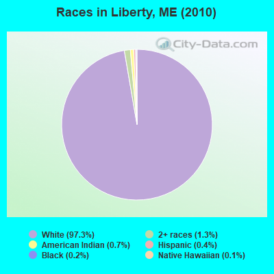
- 88897.3%White alone
- 121.3%Two or more races
- 60.7%American Indian alone
- 40.4%Hispanic
- 20.2%Black alone
- 10.1%Native Hawaiian and Other
Pacific Islander alone
Races in Liberty detailed stats: ancestries, foreign born residents, place of birth
 Recent articles from our blog. Our writers, many of them Ph.D. graduates or candidates, create easy-to-read articles on a wide variety of topics.

 | Maine weather thread (3207 replies) |
| Lake St. George in Liberty Maine (4 replies) |
| Well, here goes. The start to our trek North to Maine, our new home-state. (395 replies) |
| Maine 09/12-09/16 where to, and what to (13 replies) |
| New to Maine- What type of vehicle? (95 replies) |
| How best to get from Atlanta, Georgia to Augusta, Maine? (18 replies) |
Latest news from Liberty, ME collected exclusively by city-data.com from local newspapers, TV, and radio stations
Liberty, ME City Guides:
Ancestries: English (18.6%), Irish (14.9%), German (11.3%), French (10.1%), United States (9.9%), Italian (4.1%).
Current Local Time: EST time zone
Incorporated on 01/31/1827
Elevation: 450 feet
Land area: 25.9 square miles.
Population density: 35 people per square mile (very low).
8 residents are foreign born
| This town: | 0.9% |
| Maine: | 2.9% |
| Liberty town: | 0.9% ($768) |
| Maine: | 1.5% ($1,417) |
Nearest city with pop. 50,000+: Portland, ME  (67.4 miles , pop. 64,249).
Nearest city with pop. 200,000+: Boston, MA (167.0 miles , pop. 589,141).
Nearest city with pop. 1,000,000+: Bronx, NY (335.7 miles , pop. 1,332,650).
Nearest cities:
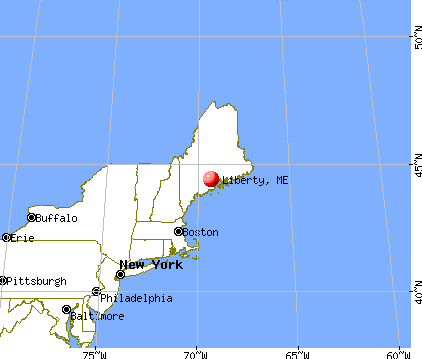
), ), ), ), )Latitude: 44.37 N, Longitude: 69.33 W
Area code: 207
| Here: | 5.0% |
| Maine: | 3.4% |

- Educational services (10.6%)
- Health care (9.8%)
- Construction (7.4%)
- Food & beverage stores (6.9%)
- Public administration (6.9%)
- Accommodation & food services (5.7%)
- Agriculture, forestry, fishing & hunting (5.4%)

- Construction (14.2%)
- Agriculture, forestry, fishing & hunting (9.6%)
- Public administration (6.6%)
- Wood products (5.1%)
- Educational services (5.1%)
- Transportation equipment (4.1%)
- Textile mills & textile products (3.6%)

- Educational services (15.7%)
- Health care (15.7%)
- Food & beverage stores (10.5%)
- Accommodation & food services (10.0%)
- Finance & insurance (8.6%)
- Public administration (7.1%)
- Professional, scientific, technical services (4.8%)

- Other production occupations, including supervisors (6.1%)
- Other office and administrative support workers, including supervisors (5.9%)
- Other management occupations, except farmers and farm managers (5.4%)
- Driver/sales workers and truck drivers (4.4%)
- Preschool, kindergarten, elementary, and middle school teachers (4.2%)
- Other sales and related occupations, including supervisors (3.9%)
- Carpenters (3.2%)

- Driver/sales workers and truck drivers (9.1%)
- Other production occupations, including supervisors (8.6%)
- Carpenters (6.6%)
- Fishing, hunting, and forestry occupations (5.6%)
- Construction traders workers except carpenters, electricians, painters, plumbers, and construction laborers (5.6%)
- Other office and administrative support workers, including supervisors (4.6%)
- Metal workers and plastic workers (4.6%)

- Other management occupations, except farmers and farm managers (8.1%)
- Preschool, kindergarten, elementary, and middle school teachers (7.1%)
- Other office and administrative support workers, including supervisors (7.1%)
- Cashiers (5.7%)
- Cooks and food preparation workers (4.8%)
- Waiters and waitresses (4.3%)
- Secretaries and administrative assistants (3.8%)
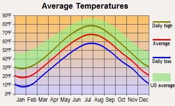
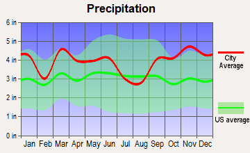
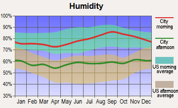
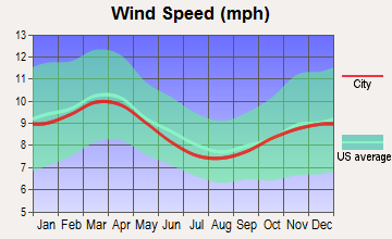
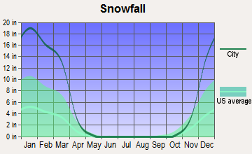
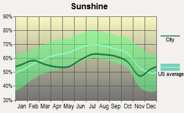
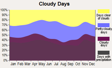
Average climate in Liberty, Maine
Based on data reported by over 4,000 weather stations
(lower is better)
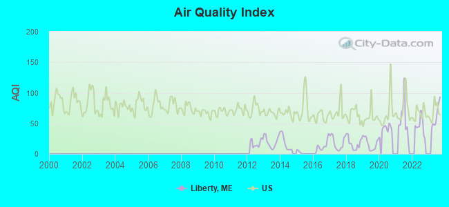
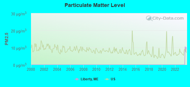
Air Quality Index (AQI) level in 2023 was 62.3. This is about average.
| City: | 62.3 |
| U.S.: | 72.6 |
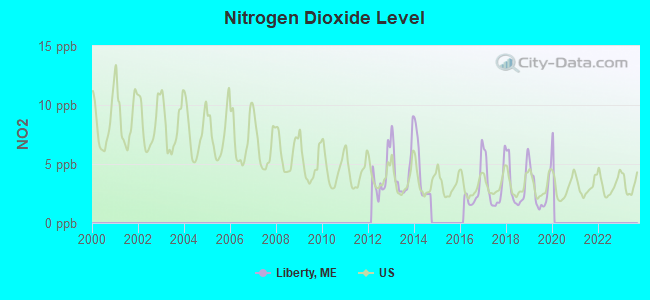
Nitrogen Dioxide (NO2) [ppb] level in 2019 was 2.80. This is significantly better than average. Closest monitor was 21.8 miles away from the city center.
| City: | 2.80 |
| U.S.: | 5.11 |
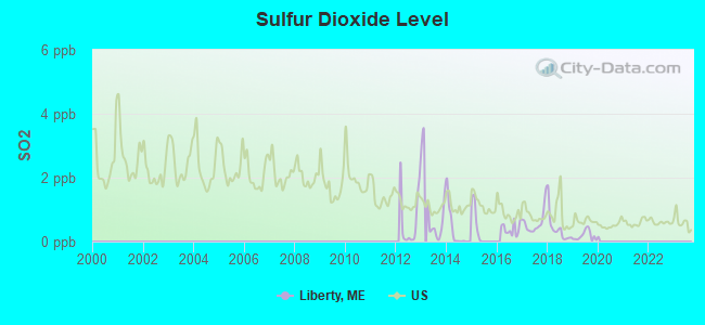
Sulfur Dioxide (SO2) [ppb] level in 2019 was 0.185. This is significantly better than average. Closest monitor was 18.5 miles away from the city center.
| City: | 0.185 |
| U.S.: | 1.515 |

Ozone [ppb] level in 2023 was 29.5. This is about average. Closest monitor was 16.1 miles away from the city center.
| City: | 29.5 |
| U.S.: | 33.3 |
Earthquake activity:
Liberty-area historical earthquake activity is significantly above Maine state average. It is 78% smaller than the overall U.S. average.On 10/16/2012 at 23:12:25, a magnitude 4.7 (4.7 ML, Depth: 10.0 mi, Class: Light, Intensity: IV - V) earthquake occurred 84.8 miles away from the city center
On 4/20/2002 at 10:50:47, a magnitude 5.3 (5.3 ML, Depth: 3.0 mi, Class: Moderate, Intensity: VI - VII) earthquake occurred 215.7 miles away from the city center
On 4/20/2002 at 10:50:47, a magnitude 5.2 (5.2 MB, 4.2 MS, 5.2 MW, 5.0 MW) earthquake occurred 216.6 miles away from the city center
On 1/19/1982 at 00:14:42, a magnitude 4.7 (4.5 MB, 4.7 MD, 4.5 LG) earthquake occurred 127.9 miles away from the city center
On 10/7/1983 at 10:18:46, a magnitude 5.3 (5.1 MB, 5.3 LG, 5.1 ML) earthquake occurred 250.1 miles away from Liberty center
On 2/26/1999 at 03:38:43, a magnitude 3.8 (3.8 LG, Depth: 2.0 mi, Class: Light, Intensity: II - III) earthquake occurred 11.9 miles away from the city center
Magnitude types: regional Lg-wave magnitude (LG), body-wave magnitude (MB), duration magnitude (MD), local magnitude (ML), surface-wave magnitude (MS), moment magnitude (MW)
Natural disasters:
The number of natural disasters in Waldo County (19) is greater than the US average (15).Major Disasters (Presidential) Declared: 15
Emergencies Declared: 3
Causes of natural disasters: Floods: 14, Storms: 11, Snows: 3, Heavy Rains: 2, Winter Storms: 2, Blizzard: 1, Hurricane: 1, Ice Storm: 1, Landslide: 1, Snowfall: 1, Wind: 1, Other: 1 (Note: some incidents may be assigned to more than one category).
Colleges/universities with over 2000 students nearest to Liberty:
- University of Maine at Augusta (about 23 miles; Augusta, ME; Full-time enrollment: 3,204)
- Husson University (about 42 miles; Bangor, ME; FT enrollment: 2,421)
- University of Maine at Farmington (about 46 miles; Farmington, ME; FT enrollment: 2,036)
- University of Maine (about 49 miles; Orono, ME; FT enrollment: 8,931)
- Southern Maine Community College (about 67 miles; South Portland, ME; FT enrollment: 4,666)
- University of Southern Maine (about 68 miles; Portland, ME; FT enrollment: 6,647)
- Saint Joseph's College of Maine (about 69 miles; Standish, ME; FT enrollment: 2,010)
Private high school in Liberty:
Public elementary/middle school in Liberty:
- WALKER MEMORIAL SCHOOL (Location: 33 WEST MAIN STREET, Grades: PK-5)
Points of interest:
Notable locations in Liberty: Fish Turn (A), Liberty Volunteer Ambulance Service (B), Liberty Volunteer Fire Department (C). Display/hide their locations on the map
Cemeteries: Fish Cemetery (1), Hannon Cemetery (2), Gove Cemetery (3), Hunt Cemetery (4). Display/hide their locations on the map
Lakes and reservoirs: Cargill Pond (A), Colby Pond (B), Little Pond (C), Stevens Pond (D), Saint George Lake (E). Display/hide their locations on the map
Park in Liberty: Lake Saint George State Park (1). Display/hide its location on the map
Tourist attraction: Davistown Museum (Main Street) (1). Display/hide its approximate location on the map
Drinking water stations with addresses in Liberty and their reported violations in the past:
MDOC ST PK - LAKE ST GEORGE (Population served: 255, Groundwater):Past monitoring violations:LORIS CAFE (Population served: 190, Groundwater):
- One routine major monitoring violation
Past monitoring violations:
- 19 routine major monitoring violations
- 4 regular monitoring violations
| This town: | 2.3 people |
| Maine: | 2.3 people |
| This town: | 65.6% |
| Whole state: | 62.9% |
| This town: | 7.8% |
| Whole state: | 9.4% |
Likely homosexual households (counted as self-reported same-sex unmarried-partner households)
- Lesbian couples: 0.3% of all households
- Gay men: 0.3% of all households
| This town: | 17.1% |
| Whole state: | 10.9% |
| This town: | 5.8% |
| Whole state: | 4.1% |
For population 15 years and over in Liberty:
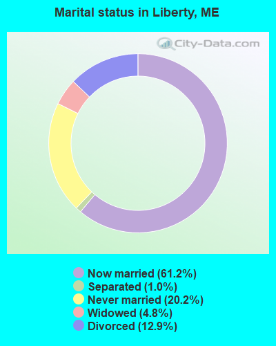
- Never married: 20.2%
- Now married: 61.2%
- Separated: 1.0%
- Widowed: 4.8%
- Divorced: 12.9%
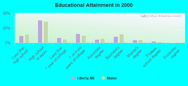
For population 25 years and over in Liberty:
- High school or higher: 87.9%
- Bachelor's degree or higher: 19.0%
- Graduate or professional degree: 8.4%
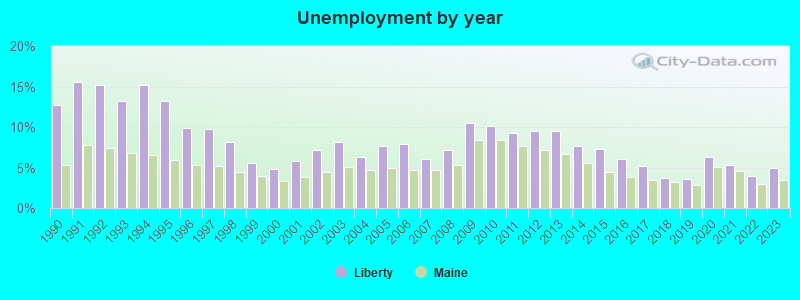
- Unemployed: 6.0%
- Mean travel time to work (commute): 33.0 minutes
| Here: | 10.1 |
| Maine average: | 11.2 |
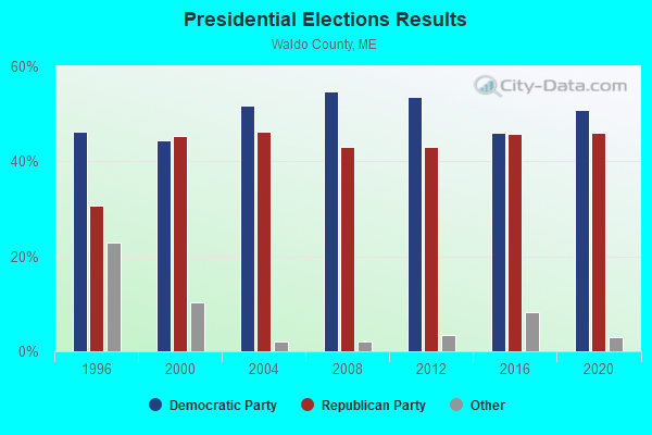
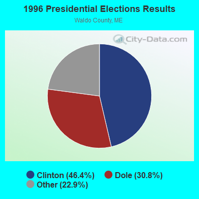
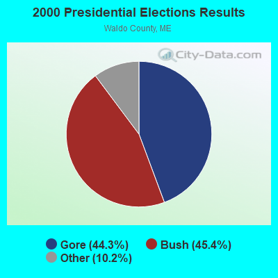
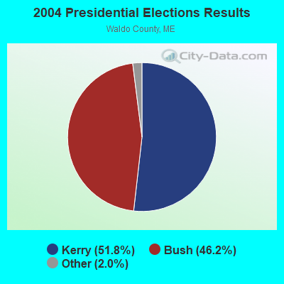
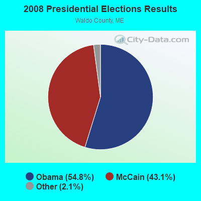
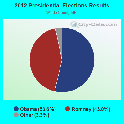
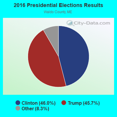
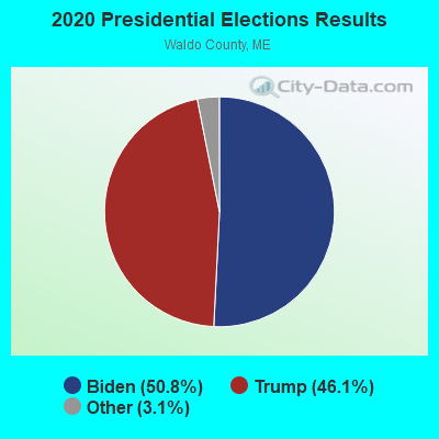
Graphs represent county-level data. Detailed 2008 Election Results
Religion statistics for Liberty, ME (based on Waldo County data)
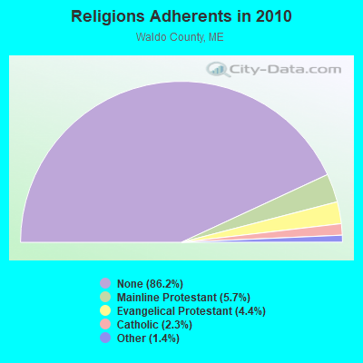
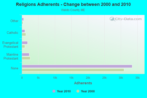
| Religion | Adherents | Congregations |
|---|---|---|
| Mainline Protestant | 2,204 | 20 |
| Evangelical Protestant | 1,711 | 23 |
| Catholic | 900 | 3 |
| Other | 554 | 7 |
| None | 33,417 | - |
Food Environment Statistics:
| Waldo County: | 2.60 / 10,000 pop. |
| State: | 2.80 / 10,000 pop. |
| Waldo County: | 1.82 / 10,000 pop. |
| Maine: | 2.20 / 10,000 pop. |
| Waldo County: | 7.02 / 10,000 pop. |
| Maine: | 5.75 / 10,000 pop. |
| This county: | 8.84 / 10,000 pop. |
| Maine: | 11.02 / 10,000 pop. |
| Waldo County: | 9.2% |
| Maine: | 8.2% |
| Waldo County: | 26.1% |
| State: | 25.0% |
Strongest AM radio stations in Liberty:
- WSKW (1160 AM; 10 kW; SKOWHEGAN, ME; Owner: MOUNTAIN WIRELESS, INCORPORATED)
- WFAU (1280 AM; 5 kW; GARDINER, ME; Owner: CAPSTAR TX LIMITED PARTNERSHIP)
- WZON (620 AM; 5 kW; BANGOR, ME; Owner: THE ZONE CORPORATION)
- WTME (780 AM; 10 kW; RUMFORD, ME; Owner: MOUNTAIN VALLEY BROADCASTING, INC.)
- WABI (910 AM; 5 kW; BANGOR, ME; Owner: CLEAR CHANNEL BROADCASTING LICENSES, INC.)
- WRKO (680 AM; 50 kW; BOSTON, MA; Owner: ENTERCOM BOSTON LICENSE, LLC)
- WDEA (1370 AM; 5 kW; ELLSWORTH, ME; Owner: CUMULUS LICENSING CORP.)
- WMTW (870 AM; 10 kW; GORHAM, ME; Owner: RADIO PARTNERS OF MAINE, L.P.)
- WEEI (850 AM; 50 kW; BOSTON, MA; Owner: ENTERCOM BOSTON LICENSE, LLC)
- WTVL (1490 AM; 1 kW; WATERVILLE, ME; Owner: CITADEL BROADCASTING COMPANY)
- WRKD (1450 AM; 1 kW; ROCKLAND, ME; Owner: CLEAR CHANNEL BROADCASTING LICENSES, INC.)
- WGAN (560 AM; 5 kW; PORTLAND, ME; Owner: SAGA COMMUNICATIONS OF NEW ENGLAND, LLC)
- WBZ (1030 AM; 50 kW; BOSTON, MA; Owner: INFINITY BROADCASTING OPERATIONS, INC.)
Strongest FM radio stations in Liberty:
- WMEP (90.5 FM; CAMDEN, ME; Owner: MAINE PUBLIC BROADCASTING CORP.)
- WQSS (102.5 FM; CAMDEN, ME; Owner: CLEAR CHANNEL BROADCASTING LICENSES, INC.)
- WWBX (97.1 FM; BANGOR, ME; Owner: CLEAR CHANNEL BROADCASTING LICENSES, INC.)
- WFZX (101.7 FM; SEARSPORT, ME; Owner: CLEAR CHANNEL BROADCASTING LICENSES, INC.)
- WMCM (103.3 FM; ROCKLAND, ME; Owner: CLEAR CHANNEL BROADCASTING LICENSES, INC.)
- WWWA (95.3 FM; WINSLOW, ME; Owner: LIGHT OF LIFE MINISTRIES, INC.)
- WBFB (104.7 FM; BELFAST, ME; Owner: CLEAR CHANNEL BROADCASTING LICENSES, INC.)
- WBQX (106.9 FM; THOMASTON, ME; Owner: MARINER BROADCASTING LIMITED PARTNER)
- WMME-FM (92.3 FM; AUGUSTA, ME; Owner: CITADEL BROADCASTING COMPANY)
- WTOS-FM (105.1 FM; SKOWHEGAN, ME; Owner: CAPSTAR TX LIMITED PARTNERSHIP)
- WKIT-FM (100.3 FM; BREWER, ME; Owner: THE ZONE CORPORATION)
- WERU-FM (89.9 FM; BLUE HILL, ME; Owner: SALT POND COMMUNITY B/C COMPANY)
- WWMJ (95.7 FM; ELLSWORTH, ME; Owner: CUMULUS LICENSING CORP.)
- WHQO (107.9 FM; SKOWHEGAN, ME; Owner: MOUNTAIN WIRELESS, INC.)
- WCTB (93.5 FM; FAIRFIELD, ME; Owner: MOUNTAIN WIRELESS, INC.)
- WMEW (91.3 FM; WATERVILLE, ME; Owner: MAINE PUBLIC BROADCASTING CORPORATION)
- WBYA (105.5 FM; ISLESBORO, ME; Owner: MARINER BROADCASTING LIMTED PARTNERSHIP)
- WEBB (98.5 FM; WATERVILLE, ME; Owner: CITADEL BROADCASTING COMPANY)
- WCME (96.7 FM; BOOTHBAY HARBOR, ME; Owner: CAPSTAR TX LIMITED PARTNERSHIP)
- WABK-FM (104.3 FM; GARDINER, ME; Owner: CAPSTAR TX LIMITED PARTNERSHIP)
TV broadcast stations around Liberty:
- WABI-TV (Channel 5; BANGOR, ME; Owner: COMMUNITY BROADCASTING SERVICE)
- WPFO (Channel 23; WATERVILLE, ME; Owner: CMCG PORTLAND LICENSE LLC)
- WFYW-LP (Channel 69; FAIRFIELD/WATERVILLE, ME; Owner: THREE ANGELS BROADCASTING NETWORK, INC.)
- DW23AB (Channel 23; WATERVILLE, ME; Owner: RUSSELL COMMUNICATIONS)
- W36CK (Channel 36; BANGOR, ME; Owner: TRINITY BROADCASTING NETWORK)
- Liberty, Maine
- Fatal accident count18
- Vehicles involved in fatal accidents33
- Fatal accidents involving drunk persons:5
- Fatalities21
- Persons involved in fatal accidents50
- Pedestrians involved in fatal accidents2
- Maine average
- Fatal accident count2574
- Vehicles involved in fatal accidents3711
- Fatal accidents involving drunk persons1008
- Fatalities2813
- Persons involved in fatal accidents6156
- Pedestrians involved in fatal accidents178
- National Bridge Inventory (NBI) Statistics
- 3Number of bridges
- 10ft / 2.7mTotal length
- 1,380Total average daily traffic
- 68Total average daily truck traffic
- 2,208Total future (year 2036) average daily traffic
FCC Registered Cell Phone Towers:
2 (See the full list of FCC Registered Cell Phone Towers in Liberty)FCC Registered Antenna Towers:
31 (See the full list of FCC Registered Antenna Towers)FCC Registered Microwave Towers:
7- LIBERTY, 12 Mi Ne Of Windsor (Lat: 44.396194 Lon: -69.359778), Type: Gtower, Structure height: 109.7 m, Overall height: 111.2 m, Call Sign: WMQ587,
Assigned Frequencies: 5945.20 MHz, Grant Date: 03/16/2021, Expiration Date: 02/01/2031, Registrant: Wilkinson Barker Knauer, LLP, 1800 M Street Nw, Suite 800n, Washington, DC 20036, Phone: (202) 383-3420, Fax: (202) 783-5851, Email:
- LIBERTY, Off Route 220 (Lat: 44.355306 Lon: -69.335722), Type: Ltower, Structure height: 49 m, Call Sign: WQFC939,
Assigned Frequencies: 6765.00 MHz, 6765.00 MHz, 6765.00 MHz, 6765.00 MHz, 6765.00 MHz, 6765.00 MHz, 6765.00 MHz, 6765.00 MHz, 957.150 MHz, Grant Date: 04/06/2016, Expiration Date: 06/19/2026, Certifier: Owen R Smith, Registrant: Radio Communications Management Inc., 158 Rand Road, Rcm, Portland, ME 04102, Phone: (207) 797-7503, Email:
- Liberty, 0.80 Km Nnw Of Sr-3, 4.82km West Of (Lat: 44.391111 Lon: -69.366111), Type: Tower, Structure height: 91.4 m, Overall height: 96 m, Call Sign: WQJF680,
Assigned Frequencies: 6805.00 MHz, Grant Date: 08/21/2008, Expiration Date: 08/21/2018, Cancellation Date: 08/06/2015, Certifier: John T Scott Iii, Registrant: Verizon Wireless, 1120 Sanctuary Pkwy, #150 Gasa5reg, Alpharetta, GA 30009-7630, Phone: (770) 797-1070, Fax: (770) 797-1036, Email:
- Liberty, 98 Tower Road (Lat: 44.392778 Lon: -69.365167), Type: Gtower, Structure height: 86.3 m, Overall height: 87.8 m, Call Sign: WQSB859,
Assigned Frequencies: 11425.0 MHz, 11385.0 MHz, 11425.0 MHz, 11385.0 MHz, 11425.0 MHz, 11385.0 MHz, 11425.0 MHz, 11385.0 MHz, 11425.0 MHz, 11385.0 MHz... (+8 more), Grant Date: 08/28/2013, Expiration Date: 08/28/2023, Cancellation Date: 09/17/2020, Certifier: Jessica B Lyons, Registrant: At&t Services, Inc., 208 S. Akard Street, Room 2100, Dallas, TX 75202, Phone: (855) 699-7073, Email:
- LIBERTY (OLD AT&T), Rt 220 (725 Pinnacle Rd) (Lat: 44.355278 Lon: -69.335833), Type: Ltower, Structure height: 64.9 m, Overall height: 71.6 m, Call Sign: WRAW553,
Assigned Frequencies: 10995.0 MHz, 10995.0 MHz, 10995.0 MHz, 10995.0 MHz, 10995.0 MHz, 10995.0 MHz, 10995.0 MHz, 10995.0 MHz, Grant Date: 03/26/2018, Expiration Date: 03/26/2028, Certifier: John Cutler, Registrant: Redzone Wireless, 91 Camden St., Suite 404, Rockland, ME 04841, Phone: (207) 596-5700, Fax: (207) 596-5701, Email:
- Liberty, Rt 220 (Lat: 44.355278 Lon: -69.335833), Type: Ltower, Structure height: 64.9 m, Overall height: 71.6 m, Call Sign: WREB696,
Assigned Frequencies: 11565.0 MHz, 11565.0 MHz, 11565.0 MHz, 11565.0 MHz, 11565.0 MHz, 11565.0 MHz, 11565.0 MHz, 11565.0 MHz, Grant Date: 09/12/2019, Expiration Date: 09/12/2029, Certifier: Jim Mckenna, Registrant: Intelpath, Hinsdale, IL 60522, Phone: (312) 841-9188, Email:
- LIBERTY, Rt 220 (Lat: 44.355333 Lon: -69.335861), Overall height: 70.4 m, Call Sign: KCB83,
Assigned Frequencies: 4010.00 MHz, 4070.00 MHz, 4010.00 MHz, 4070.00 MHz, 3770.00 MHz, 3770.00 MHz, 3850.00 MHz, 3850.00 MHz, 3930.00 MHz, 3930.00 MHz, 4090.00 MHz, 4090.00 MHz, Grant Date: 02/19/1998, Expiration Date: 02/01/2000, Cancellation Date: 05/07/2000, Phone: (404) 810-4021
FCC Registered Amateur Radio Licenses:
15 (See the full list of FCC Registered Amateur Radio Licenses in Liberty)2002 - 2018 National Fire Incident Reporting System (NFIRS) incidents
- Fire incident types reported to NFIRS in Liberty, ME
- 20684.8%Structure Fires
- 2711.1%Outside Fires
- 83.3%Mobile Property/Vehicle Fires
- 20.8%Other
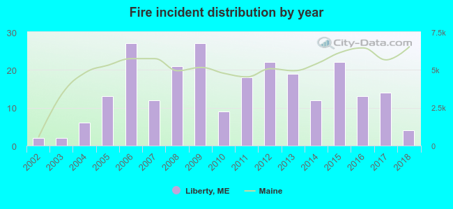 According to the data from the years 2002 - 2018 the average number of fire incidents per year is 14. The highest number of reported fire incidents - 27 took place in 2006, and the least - 2 in 2002. The data has an increasing trend.
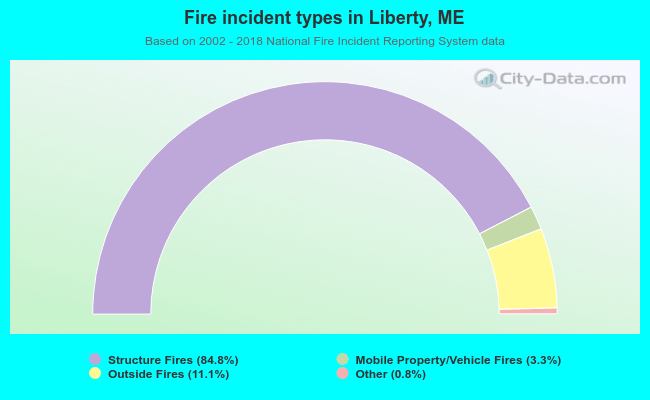 When looking into fire subcategories, the most incidents belonged to: Structure Fires (84.8%), and Outside Fires (11.1%).
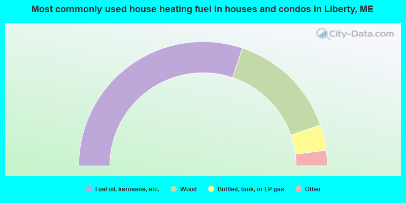
- 60.3%Fuel oil, kerosene, etc.
- 29.0%Wood
- 6.7%Bottled, tank, or LP gas
- 2.4%Other fuel
- 1.7%Electricity
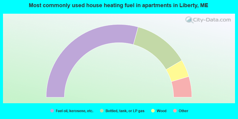
- 58.5%Fuel oil, kerosene, etc.
- 24.6%Bottled, tank, or LP gas
- 7.7%Wood
- 3.1%Utility gas
- 3.1%Electricity
- 3.1%No fuel used
Liberty compared to Maine state average:
- Unemployed percentage below state average.
- Black race population percentage significantly below state average.
- Hispanic race population percentage significantly below state average.
- Median age above state average.
- Foreign-born population percentage significantly below state average.
- Renting percentage below state average.
- Length of stay since moving in significantly above state average.
- Number of rooms per house significantly below state average.
- House age significantly below state average.
- Number of college students below state average.

|
Total of 2 patent applications in 2008-2024.