Leland, Idaho
Submit your own pictures of this place and show them to the world
- OSM Map
- General Map
- Google Map
- MSN Map

| Males: 205 | |
| Females: 186 |
| Median resident age: | 45.0 years |
| Idaho median age: | 33.2 years |
Zip code: 83537
| Leland: | $75,472 |
| ID: | $72,785 |
Estimated per capita income in 2022: $35,286 (it was $17,946 in 2000)
Leland CCD income, earnings, and wages data
Estimated median house or condo value in 2022: $314,242 (it was $95,500 in 2000)
| Leland: | $314,242 |
| ID: | $432,500 |
Mean prices in 2022: all housing units: $316,821; detached houses: $332,064; townhouses or other attached units: $264,463; in 2-unit structures: $312,880; in 3-to-4-unit structures: $229,397; mobile homes: $180,529; occupied boats, rvs, vans, etc.: $158,699
Detailed information about poverty and poor residents in Leland, ID


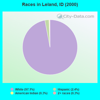
- 36797.1%White alone
- 92.4%Hispanic
- 10.3%American Indian alone
- 10.3%Two or more races
Races in Leland detailed stats: ancestries, foreign born residents, place of birth
 Recent articles from our blog. Our writers, many of them Ph.D. graduates or candidates, create easy-to-read articles on a wide variety of topics.
Current Local Time: PST time zone
Elevation: 2240 feet
Land area: 58.6 square miles.
Population density: 6.7 people per square mile (very low).

| Leland CCD: | 0.8% ($800) |
| Idaho: | 1.0% ($1,007) |
Nearest city with pop. 50,000+: Spokane Valley, WA (81.9 miles  , pop. 89,755).
Nearest city with pop. 200,000+: East Seattle, WA (273.8 miles , pop. 480,100).
Nearest city with pop. 1,000,000+: Los Angeles, CA (869.9 miles , pop. 3,694,820).
Nearest cities:
), ), ), Latitude: 46.59 N, Longitude: 116.55 W
Area code commonly used in this area: 208

| Here: | 2.7% |
| Idaho: | 3.1% |
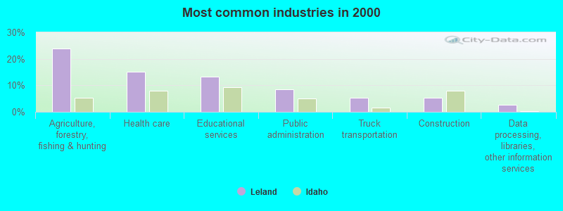
- Agriculture, forestry, fishing & hunting (23.8%)
- Health care (15.2%)
- Educational services (13.2%)
- Public administration (8.6%)
- Truck transportation (5.3%)
- Construction (5.3%)
- Data processing, libraries, other information services (2.6%)
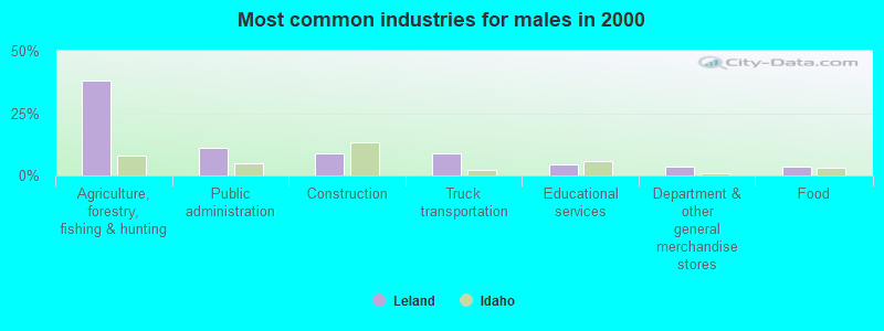
- Agriculture, forestry, fishing & hunting (38.2%)
- Public administration (11.2%)
- Construction (9.0%)
- Truck transportation (9.0%)
- Educational services (4.5%)
- Department & other general merchandise stores (3.4%)
- Food (3.4%)
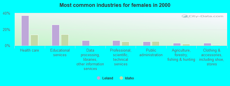
- Health care (37.1%)
- Educational services (25.8%)
- Data processing, libraries, other information services (6.5%)
- Professional, scientific, technical services (6.5%)
- Public administration (4.8%)
- Agriculture, forestry, fishing & hunting (3.2%)
- Clothing & accessories, including shoe, stores (3.2%)
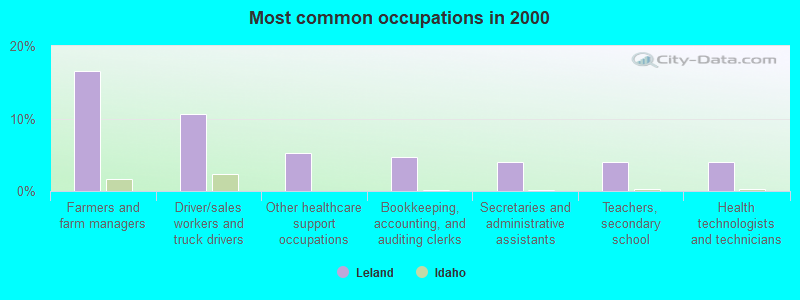
- Farmers and farm managers (16.6%)
- Driver/sales workers and truck drivers (10.6%)
- Other healthcare support occupations (5.3%)
- Bookkeeping, accounting, and auditing clerks (4.6%)
- Secretaries and administrative assistants (4.0%)
- Teachers, secondary school (4.0%)
- Health technologists and technicians (4.0%)
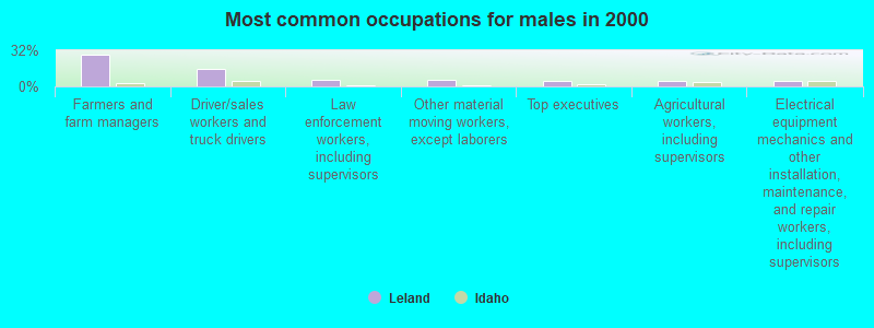
- Farmers and farm managers (28.1%)
- Driver/sales workers and truck drivers (15.7%)
- Law enforcement workers, including supervisors (5.6%)
- Other material moving workers, except laborers (5.6%)
- Top executives (4.5%)
- Agricultural workers, including supervisors (4.5%)
- Electrical equipment mechanics and other installation, maintenance, and repair workers, including supervisors (4.5%)
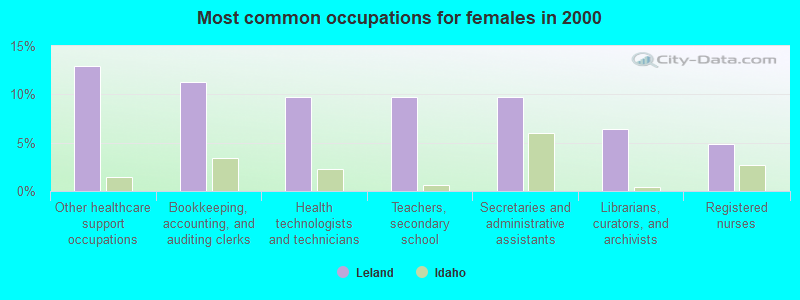
- Other healthcare support occupations (12.9%)
- Bookkeeping, accounting, and auditing clerks (11.3%)
- Health technologists and technicians (9.7%)
- Teachers, secondary school (9.7%)
- Secretaries and administrative assistants (9.7%)
- Librarians, curators, and archivists (6.5%)
- Registered nurses (4.8%)
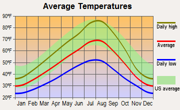
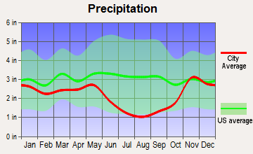
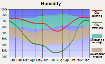
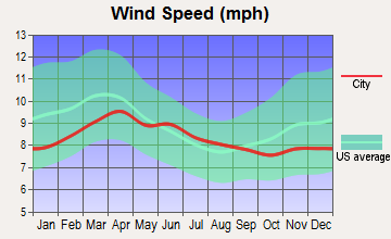
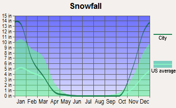
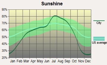
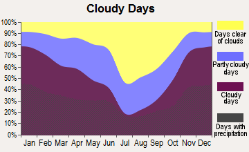
Average climate in Leland, Idaho
Based on data reported by over 4,000 weather stations
(lower is better)
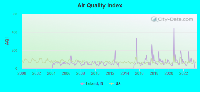
Air Quality Index (AQI) level in 2022 was 70.1. This is about average.
| City: | 70.1 |
| U.S.: | 72.6 |
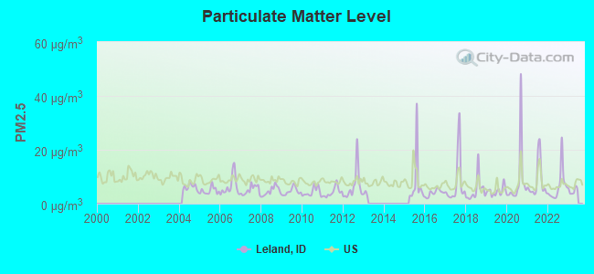
Particulate Matter (PM2.5) [µg/m3] level in 2022 was 6.51. This is better than average. Closest monitor was 21.7 miles away from the city center.
| City: | 6.51 |
| U.S.: | 8.11 |
Earthquake activity:
Leland-area historical earthquake activity is significantly above Idaho state average. It is 1060% greater than the overall U.S. average.On 10/28/1983 at 14:06:06, a magnitude 7.3 (6.2 MB, 7.3 MS, 7.0 MW, Class: Major, Intensity: VIII - XII) earthquake occurred 219.0 miles away from the city center, causing 2 deaths (2 shaking deaths) and 3 injuries, causing $15,000,000 total damage
On 8/18/1959 at 06:37:13, a magnitude 7.7 (7.7 UK) earthquake occurred 317.6 miles away from the city center, causing $26,000,000 total damage
On 3/31/2020 at 23:52:30, a magnitude 6.5 (6.5 MW, Depth: 7.5 mi, Class: Strong, Intensity: VII - IX) earthquake occurred 162.3 miles away from Leland center
On 4/13/1949 at 19:55:42, a magnitude 7.0 (7.0 UK) earthquake occurred 284.8 miles away from the city center, causing $80,000,000 total damage
On 10/3/1915 at 06:52:48, a magnitude 7.6 (7.6 UK) earthquake occurred 423.6 miles away from the city center
On 2/28/2001 at 18:54:32, a magnitude 6.8 (6.5 MB, 6.6 MS, 6.8 MW) earthquake occurred 287.4 miles away from the city center, causing $2,000,000,000 total damage and $305,000,000 insured losses
Magnitude types: body-wave magnitude (MB), surface-wave magnitude (MS), moment magnitude (MW)
Natural disasters:
The number of natural disasters in Nez Perce County (9) is smaller than the US average (15).Major Disasters (Presidential) Declared: 7
Emergencies Declared: 1
Causes of natural disasters: Floods: 5, Heavy Rains: 2, Storms: 2, Fire: 1, Hurricane: 1, Landslide: 1, Mudslide: 1, Volcanic Eruption: 1, Other: 1 (Note: some incidents may be assigned to more than one category).
Colleges/universities with over 2000 students nearest to Leland:
- University of Idaho (about 25 miles; Moscow, ID; Full-time enrollment: 10,416)
- Lewis-Clark State College (about 26 miles; Lewiston, ID; FT enrollment: 3,199)
- Washington State University (about 31 miles; Pullman, WA; FT enrollment: 25,055)
- North Idaho College (about 77 miles; Coeur d'Alene, ID; FT enrollment: 4,684)
- Eastern Washington University (about 80 miles; Cheney, WA; FT enrollment: 11,643)
- Spokane Community College (about 85 miles; Spokane, WA; FT enrollment: 6,482)
- Gonzaga University (about 85 miles; Spokane, WA; FT enrollment: 6,780)
Points of interest:
Cemeteries: Leland Cemetery (1), Kendrick Cemetery (2). Display/hide their locations on the map
Creeks: Leopold Creek (A), Big Bear Creek (B), Louse Creek (C). Display/hide their locations on the map
| This place: | 2.2 people |
| Idaho: | 2.7 people |
| This place: | 71.7% |
| Whole state: | 69.6% |
| This place: | 5.7% |
| Whole state: | 6.3% |
Likely homosexual households (counted as self-reported same-sex unmarried-partner households)
- Lesbian couples: 1.3% of all households
- Gay men: 0.0% of all households
| This place: | 7.7% |
| Whole state: | 11.8% |
| This place: | 7.2% |
| Whole state: | 4.6% |
For population 15 years and over in Leland:
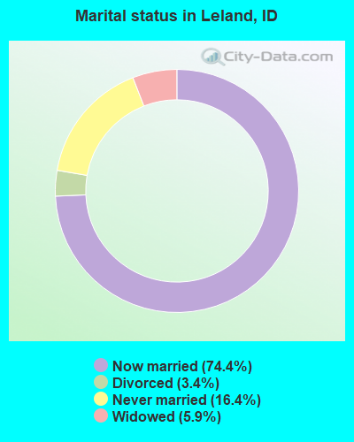
- Never married: 16.4%
- Now married: 74.4%
- Separated: 0.0%
- Widowed: 5.9%
- Divorced: 3.4%
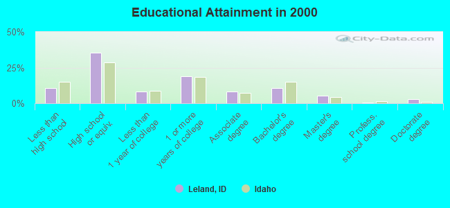
For population 25 years and over in Leland:
- High school or higher: 89.5%
- Bachelor's degree or higher: 18.9%
- Graduate or professional degree: 8.4%
- Unemployed: 7.4%
- Mean travel time to work (commute): 33.1 minutes
| Here: | 9.9 |
| Idaho average: | 11.1 |
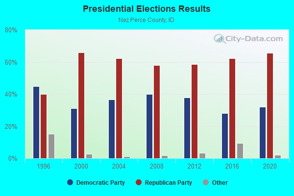
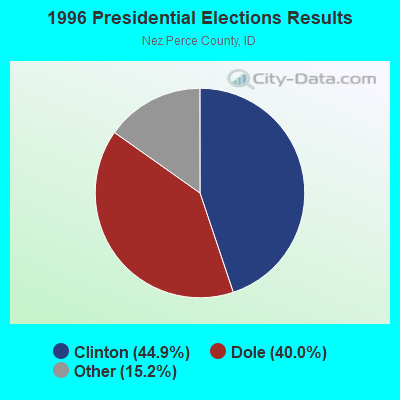
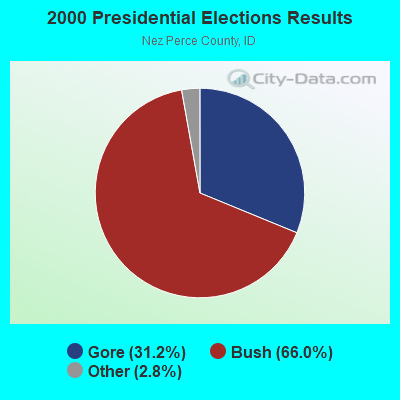
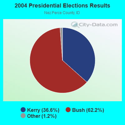
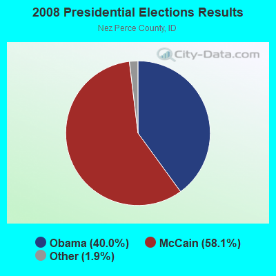
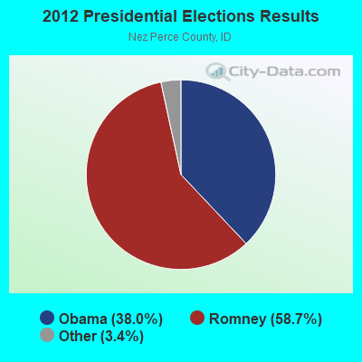
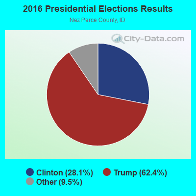
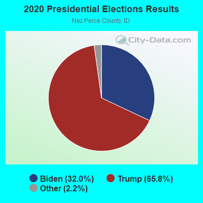
Graphs represent county-level data. Detailed 2008 Election Results
Religion statistics for Leland, ID (based on Nez Perce County data)
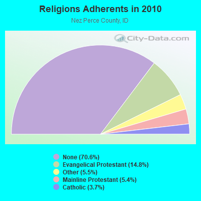
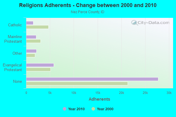
| Religion | Adherents | Congregations |
|---|---|---|
| Evangelical Protestant | 5,793 | 32 |
| Other | 2,163 | 9 |
| Mainline Protestant | 2,116 | 12 |
| Catholic | 1,468 | 4 |
| None | 27,725 | - |
Food Environment Statistics:
| This county: | 2.83 / 10,000 pop. |
| Idaho: | 1.88 / 10,000 pop. |
| Nez Perce County: | 0.52 / 10,000 pop. |
| State: | 0.53 / 10,000 pop. |
| This county: | 3.61 / 10,000 pop. |
| State: | 3.87 / 10,000 pop. |
| This county: | 6.96 / 10,000 pop. |
| Idaho: | 7.75 / 10,000 pop. |
| This county: | 10.5% |
| State: | 7.7% |
| Nez Perce County: | 29.2% |
| State: | 25.7% |
| Nez Perce County: | 20.4% |
| Idaho: | 11.7% |
Strongest AM radio stations in Leland:
- KQQQ (1150 AM; 25 kW; PULLMAN, WA; Owner: RADIO PALOUSE, INC.)
- KLER (1300 AM; 5 kW; OROFINO, ID; Owner: CENTRAL IDAHO BROADCASTING)
- KOZE (950 AM; 5 kW; LEWISTON, ID; Owner: 4-K RADIO, INC.)
- KMAX (840 AM; 10 kW; COLFAX, WA; Owner: PALOUSE COUNTRY, INC.)
- KGA (1510 AM; 50 kW; SPOKANE, WA; Owner: CITADEL BROADCASTING COMPANY)
- KRLC (1350 AM; 5 kW; CLARKSTON LEWISTON,, WA; Owner: IDA-VEND COMPANY, INC.)
- KCLK (1430 AM; 5 kW; ASOTIN, WA; Owner: CLARKSTON BROADCASTERS, INC.)
- KWSU (1250 AM; 5 kW; PULLMAN, WA; Owner: WASHINGTON STATE UNIVERSITY)
- KERR (750 AM; 50 kW; POLSON, MT; Owner: ANDERSON RADIO BROADCASTING, INC.)
- KXLY (920 AM; 20 kW; SPOKANE, WA; Owner: SPOKANE RADIO, INC.)
- KTBI (810 AM; daytime; 50 kW; EPHRATA, WA; Owner: TACOMA BROADCASTERS, INCORPORATED)
- KMJY (700 AM; 10 kW; NEWPORT, WA; Owner: JAMES E. AND HELEN G. STARGEL)
- KVNI (1080 AM; 10 kW; COEUR D' ALENE, ID; Owner: QUEENB RADIO, INC.)
Strongest FM radio stations in Leland:
- KHTR (104.3 FM; PULLMAN, WA; Owner: RADIO PALOUSE, INC.)
- KZZL-FM (99.5 FM; PULLMAN, WA; Owner: PALOUSE COUNTRY, INC.)
- K213BN (90.5 FM; OROFINO, ID; Owner: ALACCA BIBLE CONFERENCE, INC.)
- KLER-FM (95.3 FM; OROFINO, ID; Owner: CENTRAL IDAHO BROADCASTING)
- K272DO (102.3 FM; OROFINO, ID; Owner: WASHINGTON STATE UNIVERSITY)
- KMOK (106.9 FM; LEWISTON, ID; Owner: IDA-VEND COMPANY, INC.)
- KNWO (90.1 FM; COTTONWOOD, ID; Owner: WASHINGTON STATE UNIVERSITY)
- KZFN (106.1 FM; MOSCOW, ID; Owner: KRPL, INC.)
- KRFA-FM (91.7 FM; MOSCOW, ID; Owner: WASHINGTON STATE UNIVERSITY)
- KVTY (105.1 FM; LEWISTON, ID; Owner: IDAVEND CO. INC.)
- KOZE-FM (96.5 FM; LEWISTON, ID; Owner: 4-K RADIO, INC.)
- KCLK-FM (94.1 FM; CLARKSTON, WA; Owner: CLARKSTON BROADCASTERS, INC.)
- KVAB (102.9 FM; CLARKSTON, WA; Owner: CLARKSTON BROADCASTERS, INC.)
- KNWV (90.5 FM; CLARKSTON, WA; Owner: WASHINGTON STATE UNIVERSITY)
- KATW (101.5 FM; LEWISTON, ID; Owner: PACIFIC EMPIRE COMMUNICATIONS CORP.)
- KORT-FM (92.7 FM; GRANGEVILLE, ID; Owner: 4-K RADIO, INC.)
- KRLF (88.5 FM; PULLMAN, WA; Owner: LIVING FAITH F/SHIP EDUC. MINISTRIES)
- KRAO-FM (102.5 FM; COLFAX, WA; Owner: PALOUSE COUNTRY, INC.)
TV broadcast stations around Leland:
- KUID-TV (Channel 12; MOSCOW, ID; Owner: STATE BOARD OF EDUCATION, STATE OF IDAHO)
- K07NL (Channel 7; JULIAETTA, ID; Owner: JULIAETTA TELEVISION ASSOCIATION)
- K09DF (Channel 9; JULIAETTA, ID; Owner: JULIAETTA TELEVISION ASSOCIATION)
- K41GW (Channel 41; JULIAETTA, ID; Owner: JULIAETTA TELEVISION ASSOCIATION)
- K48HB (Channel 48; JULIAETTA, ID; Owner: JULIAETTA TELEVISION ASSOCIATION)
- K43GE (Channel 43; JULIAETTA, ID; Owner: STATE BOARD OF EDUCATION (IEPBS))
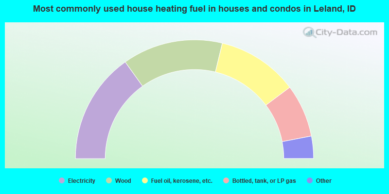
- 30.3%Electricity
- 27.3%Wood
- 22.0%Fuel oil, kerosene, etc.
- 14.4%Bottled, tank, or LP gas
- 3.0%Other fuel
- 1.5%Utility gas
- 1.5%No fuel used
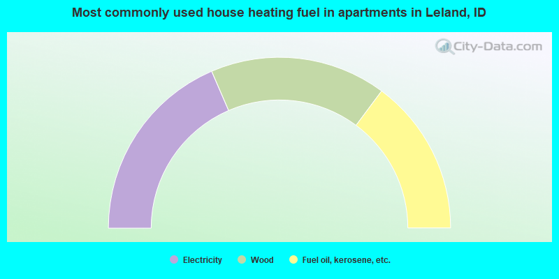
- 37.0%Electricity
- 33.3%Wood
- 29.6%Fuel oil, kerosene, etc.
Leland compared to Idaho state average:
- Black race population percentage significantly below state average.
- Hispanic race population percentage significantly below state average.
- Foreign-born population percentage significantly below state average.
- Renting percentage below state average.
- Length of stay since moving in significantly above state average.
- Number of rooms per house significantly below state average.
- House age significantly below state average.
- Number of college students significantly below state average.