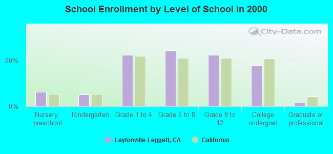
Laytonville-Leggett, California
Submit your own pictures of this place and show them to the world
- OSM Map
- Google Map
- MSN Map
| Males: 2,068 | |
| Females: 1,898 |
| Median resident age: | 40.8 years |
| California median age: | 33.3 years |
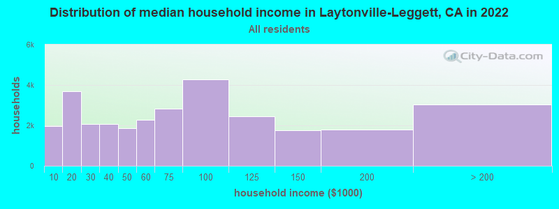
| Laytonville-Leggett: | $56,326 |
| CA: | $91,551 |
Estimated per capita income in 2022: $38,909 (it was $19,235 in 2000)
Laytonville-Leggett CCD income, earnings, and wages data
Estimated median house or condo value in 2022: $407,228 (it was $139,000 in 2000)
| Laytonville-Leggett: | $407,228 |
| CA: | $715,900 |
Mean prices in 2022: all housing units: $543,293; detached houses: $599,740; townhouses or other attached units: $578,121; in 2-unit structures: $619,716; in 3-to-4-unit structures: $580,324; mobile homes: $187,001; occupied boats, rvs, vans, etc.: $113,877
Laytonville-Leggett, CA residents, houses, and apartments details
Detailed information about poverty and poor residents in Laytonville-Leggett, CA


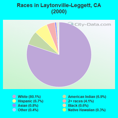
- 3,21080.1%White alone
- 2766.9%American Indian alone
- 2676.7%Hispanic
- 1654.1%Two or more races
- 330.8%Asian alone
- 240.6%Black alone
- 160.4%Other race alone
- 140.3%Native Hawaiian and Other
Pacific Islander alone
 Recent articles from our blog. Our writers, many of them Ph.D. graduates or candidates, create easy-to-read articles on a wide variety of topics.
Current Local Time: PST time zone
Land area: 740.0 square miles.
Population density: 5.4 people per square mile (very low).
| Laytonville-Leggett CCD: | 0.5% ($735) |
| California: | 0.8% ($1,564) |
Nearest city with pop. 50,000+: Redding, CA  (87.7 miles , pop. 80,865).
Nearest city with pop. 200,000+: Sacramento, CA (143.5 miles , pop. 407,018).
Nearest city with pop. 1,000,000+: Los Angeles, CA (488.7 miles , pop. 3,694,820).
Nearest cities:
), ), ), Latitude: 39.76 N, Longitude: 123.64 W
Area code commonly used in this area: 707
| Here: | 5.4% |
| California: | 5.1% |
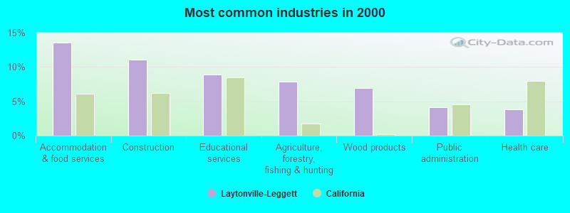
- Accommodation & food services (13.6%)
- Construction (11.1%)
- Educational services (8.9%)
- Agriculture, forestry, fishing & hunting (7.8%)
- Wood products (6.9%)
- Public administration (4.1%)
- Health care (3.8%)
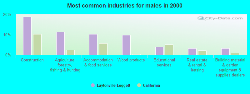
- Construction (18.9%)
- Agriculture, forestry, fishing & hunting (11.3%)
- Accommodation & food services (10.3%)
- Wood products (9.8%)
- Educational services (4.0%)
- Real estate & rental & leasing (3.3%)
- Building material & garden equipment & supplies dealers (3.3%)
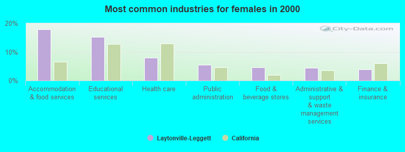
- Accommodation & food services (17.8%)
- Educational services (15.1%)
- Health care (8.0%)
- Public administration (5.4%)
- Food & beverage stores (4.5%)
- Administrative & support & waste management services (4.4%)
- Finance & insurance (3.9%)
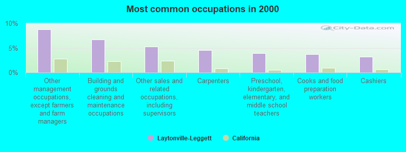
- Other management occupations, except farmers and farm managers (8.7%)
- Building and grounds cleaning and maintenance occupations (6.7%)
- Other sales and related occupations, including supervisors (5.3%)
- Carpenters (4.5%)
- Preschool, kindergarten, elementary, and middle school teachers (3.9%)
- Cooks and food preparation workers (3.7%)
- Cashiers (3.2%)
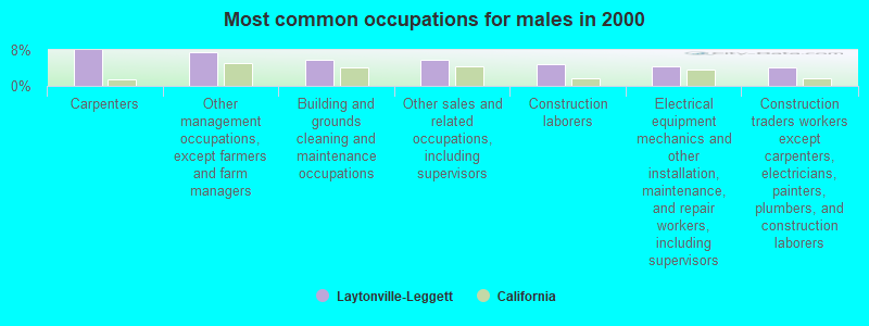
- Carpenters (8.0%)
- Other management occupations, except farmers and farm managers (7.6%)
- Building and grounds cleaning and maintenance occupations (5.9%)
- Other sales and related occupations, including supervisors (5.8%)
- Construction laborers (4.9%)
- Electrical equipment mechanics and other installation, maintenance, and repair workers, including supervisors (4.5%)
- Construction traders workers except carpenters, electricians, painters, plumbers, and construction laborers (4.1%)
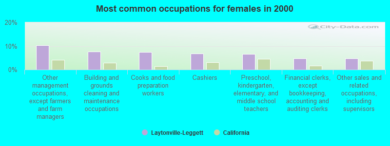
- Other management occupations, except farmers and farm managers (10.2%)
- Building and grounds cleaning and maintenance occupations (7.7%)
- Cooks and food preparation workers (7.4%)
- Cashiers (6.8%)
- Preschool, kindergarten, elementary, and middle school teachers (6.6%)
- Financial clerks, except bookkeeping, accounting and auditing clerks (4.8%)
- Other sales and related occupations, including supervisors (4.6%)
Average climate in Laytonville-Leggett, California
Based on data reported by over 4,000 weather stations


(lower is better)
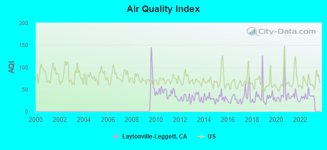
Air Quality Index (AQI) level in 2022 was 34.1. This is significantly better than average.
| City: | 34.1 |
| U.S.: | 72.6 |
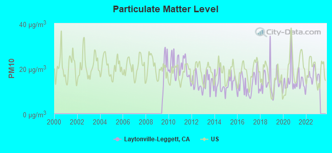
Particulate Matter (PM10) [µg/m3] level in 2022 was 16.8. This is about average. Closest monitor was 23.6 miles away from the city center.
| City: | 16.8 |
| U.S.: | 19.2 |
Earthquake activity:
Laytonville-Leggett-area historical earthquake activity is significantly above California state average. It is 5555% greater than the overall U.S. average.On 4/18/1906 at 13:12:21, a magnitude 7.9 (7.9 UK, Class: Major, Intensity: VIII - XII) earthquake occurred 126.8 miles away from the city center, causing $524,000,000 total damage
On 1/31/1922 at 13:17:28, a magnitude 7.6 (7.6 UK) earthquake occurred 119.8 miles away from the city center
On 4/25/1992 at 18:06:04, a magnitude 7.2 (6.3 MB, 7.1 MS, 7.2 MW, 7.1 MW, Depth: 9.4 mi) earthquake occurred 46.3 miles away from Laytonville-Leggett center, causing $75,000,000 total damage
On 11/8/1980 at 10:27:34, a magnitude 7.2 (6.2 MB, 7.2 MS, 7.2 MW, 7.0 ML) earthquake occurred 99.3 miles away from the city center
On 1/22/1923 at 09:04:18, a magnitude 7.2 (7.2 UK) earthquake occurred 101.9 miles away from Laytonville-Leggett center
On 9/1/1994 at 15:15:53, a magnitude 7.1 (6.6 MB, 7.0 MS, 7.1 MW, 6.8 ML, Depth: 6.2 mi) earthquake occurred 120.6 miles away from the city center
Magnitude types: body-wave magnitude (MB), local magnitude (ML), surface-wave magnitude (MS), moment magnitude (MW)
Natural disasters:
The number of natural disasters in Mendocino County (25) is a lot greater than the US average (15).Major Disasters (Presidential) Declared: 14
Emergencies Declared: 3
Causes of natural disasters: Floods: 17, Storms: 9, Winter Storms: 8, Landslides: 6, Mudslides: 5, Fires: 4, Drought: 1, Freeze: 1, Heavy Rain: 1, Hurricane: 1, Tornado: 1, Other: 1 (Note: some incidents may be assigned to more than one category).
Colleges/universities with over 2000 students nearest to Laytonville-Leggett:
- Mendocino College (about 46 miles; Ukiah, CA; Full-time enrollment: 2,263)
- College of the Redwoods (about 71 miles; Eureka, CA; FT enrollment: 4,410)
- Humboldt State University (about 81 miles; Arcata, CA; FT enrollment: 7,353)
- Shasta College (about 93 miles; Redding, CA; FT enrollment: 5,645)
- California State University-Chico (about 96 miles; Chico, CA; FT enrollment: 14,838)
- Santa Rosa Junior College (about 104 miles; Santa Rosa, CA; FT enrollment: 13,047)
- Butte College (about 107 miles; Oroville, CA; FT enrollment: 8,649)
Points of interest:
Notable locations in Laytonville-Leggett: Camp Rest (A), Camp Saint Michael (B), Camp Seabow (C), Chandelier Tree (D), Clarke Ranch (E), Wilderness Lodge (F), Usal (G), The Hermitage (H), Strauss Orchard (I), Rockport Fire Station (J), Reynolds State Wayside Campground (K), Redwine Ranch (L), Redwine Cabin (M), O'Conner Orchard (N), Moody (O), Captain Miles Standish Tree (P), Medcalf Ranch (Q), Blue Rock Ranch (R), Drewry Ranch (S), Bell Springs (T). Display/hide their locations on the map
Church in Laytonville-Leggett: Our Lady of the Redwoods Abbey (A). Display/hide its location on the map
Cemeteries: Lilley Grave Cemetery (1), Laytonville Cemetery (2), Newport Cemetery (3). Display/hide their locations on the map
Lakes: Vinton Lake (A), Twin Lakes (B), Farley Lake (C). Display/hide their locations on the map
Rivers and creeks: Black Oak Creek (A), Bond Creek (B), Brad Turner Creek (C), Bridges Creek (D), Buckhorn Creek (E), Burns Creek (F), Butler Creek (G), Cahto Creek (H), Cedar Creek (I). Display/hide their locations on the map
Parks in Laytonville-Leggett include: Admiral William Standley State Recreation Area (1), Standish-Hickey State Recreation Area (2), Westport-Union Landing State Beach (3), Sinkyone Wilderness State Park (4), Empire Roadside Rest (5), Honky Tonk Picnic Area (6). Display/hide their locations on the map
Beaches: Wages Creek Beach (A), Seaside Creek Beach (B). Display/hide their locations on the map
| This place: | 2.3 people |
| California: | 2.9 people |
| This place: | 54.5% |
| Whole state: | 68.7% |
| This place: | 12.1% |
| Whole state: | 7.2% |
Likely homosexual households (counted as self-reported same-sex unmarried-partner households)
- Lesbian couples: 0.8% of all households
- Gay men: 0.7% of all households
| This place: | 22.2% |
| Whole state: | 14.2% |
| This place: | 9.8% |
| Whole state: | 6.3% |
18 people in homes or halfway houses for drug/alcohol abuse in 2000
9 people in other noninstitutional group quarters in 2000
For population 15 years and over in Laytonville-Leggett:
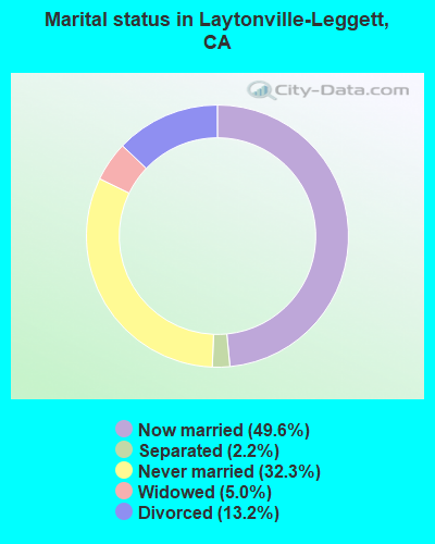
- Never married: 32.3%
- Now married: 49.6%
- Separated: 2.2%
- Widowed: 5.0%
- Divorced: 13.2%
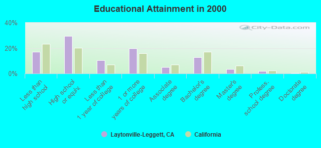
For population 25 years and over in Laytonville-Leggett:
- High school or higher: 82.9%
- Bachelor's degree or higher: 18.3%
- Graduate or professional degree: 5.6%
- Unemployed: 10.8%
- Mean travel time to work (commute): 18.7 minutes
| Here: | 10.2 |
| California average: | 16.1 |
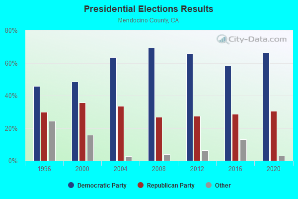
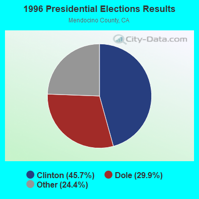
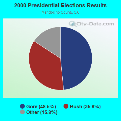
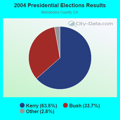
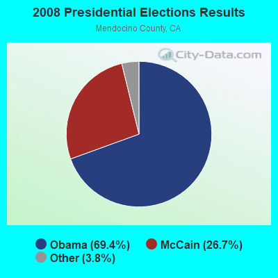
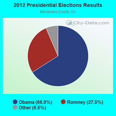
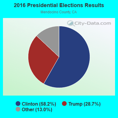
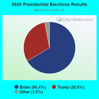
Graphs represent county-level data. Detailed 2008 Election Results
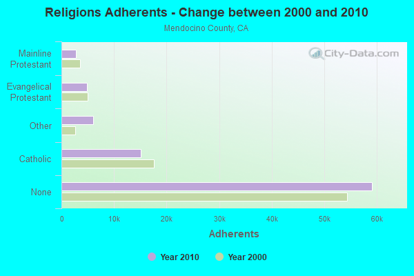
Religion statistics for Laytonville-Leggett, CA (based on Mendocino County data)
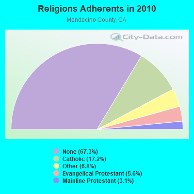
| Religion | Adherents | Congregations |
|---|---|---|
| Catholic | 15,081 | 11 |
| Other | 6,014 | 29 |
| Evangelical Protestant | 4,912 | 54 |
| Mainline Protestant | 2,730 | 25 |
| Orthodox | - | - |
| None | 59,104 | - |
Food Environment Statistics:
| Here: | 5.93 / 10,000 pop. |
| California: | 2.14 / 10,000 pop. |
| Mendocino County: | 0.70 / 10,000 pop. |
| California: | 0.62 / 10,000 pop. |
| Here: | 4.42 / 10,000 pop. |
| State: | 1.49 / 10,000 pop. |
| Mendocino County: | 13.84 / 10,000 pop. |
| California: | 7.42 / 10,000 pop. |
| Mendocino County: | 7.1% |
| California: | 7.3% |
| Mendocino County: | 20.4% |
| California: | 21.3% |
| Mendocino County: | 19.5% |
| State: | 17.9% |
Strongest AM radio stations in Laytonville-Leggett:
- KLLK (1250 AM; 5 kW; WILLITS, CA; Owner: MOON BROADCASTING UKIAH, LLC)
- KPMO (1300 AM; 5 kW; MENDOCINO, CA; Owner: JPR FOUNDATION INC.)
- KCBS (740 AM; 50 kW; SAN FRANCISCO, CA; Owner: INFINITY BROADCASTING OPERATIONS, INC.)
- KNCR (1090 AM; daytime; 10 kW; FORTUNA, CA; Owner: MILLER BROADCASTING COMPANY, INC.)
- KTRB (860 AM; 50 kW; MODESTO, CA; Owner: PAPPAS RADIO OF CALIFORNIA, A CALIFORNIA LIMITED PARTNERSHIP)
- KNBR (680 AM; 50 kW; SAN FRANCISCO, CA; Owner: KNBR LICO, INC.)
- KGO (810 AM; 50 kW; SAN FRANCISCO, CA; Owner: KGO-AM RADIO, INC.)
- KFBK (1530 AM; 50 kW; SACRAMENTO, CA; Owner: AMFM RADIO LICENSES, L.L.C.)
- KFIA (710 AM; 25 kW; CARMICHAEL, CA; Owner: VISTA BROADCASTING INC.)
- KTCT (1050 AM; 50 kW; SAN MATEO, CA; Owner: SUSQUEHANNA RADIO CORP.)
- KHTK (1140 AM; 50 kW; SACRAMENTO, CA; Owner: INFINITY RADIO SUBSIDIARY OPERATIONS INC.)
- KFAX (1100 AM; 50 kW; SAN FRANCISCO, CA; Owner: GOLDEN GATE BROADCASTING CO, INC.)
- KCBC (770 AM; 50 kW; RIVERBANK, CA; Owner: KIERTRON, INC.)
Strongest FM radio stations in Laytonville-Leggett:
- K209EU (89.7 FM; LAYTONVILLE, CA; Owner: CALVARY CHAPEL OF TWIN FALLS, INC.)
- KHKL (91.9 FM; LAYTONVILLE, CA; Owner: EDUCATIONAL MEDIA FOUNDATION)
- KMKX (93.5 FM; WILLITS, CA; Owner: RADIO MILLENNIUM L L C)
- KLVG (103.7 FM; GARBERVILLE, CA; Owner: EDUCATIONAL MEDIA FOUNDATION)
- KHUM (104.7 FM; GARBERVILLE, CA; Owner: LOST COAST COMMUNICATIONS, INC.)
- KMUD (91.1 FM; GARBERVILLE, CA; Owner: REDWOOD COMMUNITY RADIO, INC.)
- K201HL (88.1 FM; GARBERVILLE, CA; Owner: CALVARY CHAPEL OF TWIN FALLS, INC.)
- K235AM (94.9 FM; GARBERVILLE, CA; Owner: FAMILY STATIONS, INC.)
- KUKI-FM (103.3 FM; UKIAH, CA; Owner: MOON BROADCASTING UKIAH, LLC)
- KZYZ (91.5 FM; WILLITS, CA; Owner: MENDOCINO COUNTY PUBLIC BROADCASTING)
- K264AH (100.7 FM; WILLITS, CA; Owner: CALVARY CHAPEL OF TWIN FALLS, INC.)
- KEKA-FM (101.5 FM; EUREKA, CA; Owner: EUREKA BROADCASTING CO., INC.)
- KHRD (103.1 FM; WEAVERVILLE, CA; Owner: RESULTS RADIO LICENSEE, LLC)
- KNCQ (97.3 FM; REDDING, CA; Owner: RESULTS RADIO OF REDDING, LLC)
- KWNE (94.5 FM; UKIAH, CA; Owner: BROADCASTING CORP. OF MENDICINO CTY.)
- KQPM (105.9 FM; UKIAH, CA; Owner: BICOASTAL MEDIA LLC)
- K296ES (107.1 FM; LAKEPORT, CA; Owner: MOON BROADCASTING UKIAH, LLC)
- KNTI (99.5 FM; LAKEPORT, CA; Owner: BICOASTAL MEDIA LLC)
- KZYX (90.7 FM; PHILO, CA; Owner: MENDOCINO COUNTY PUBLIC BROADCASTING)
- KSRT (107.1 FM; CLOVERDALE, CA; Owner: POINT BROADCASTING)
TV broadcast stations around Laytonville-Leggett:
- KFWU (Channel 8; FORT BRAGG, CA; Owner: CONCORD LICENSE, LLC)
- K06FR (Channel 6; LAYTONVILLE, ETC., CA; Owner: LESTER J. DIETZ)
- K08GJ (Channel 8; LAYTONVILLE, ETC., CA; Owner: LESTER J. DIETZ)
- K10GL (Channel 10; LAYTONVILLE, ETC., CA; Owner: LESTER J. DIETZ)
- K12GV (Channel 12; LAYTONVILLE, ETC., CA; Owner: LESTER J. DIETZ)
- K61CJ (Channel 61; LAYTONVILLE, ETC., CA; Owner: LESTER J. DIETZ)
- National Bridge Inventory (NBI) Statistics
- 1Number of bridges
- 10ft / 2.5mTotal length
- 3,000Total average daily traffic
- 300Total average daily truck traffic
- 3,510Total future (year 2041) average daily traffic
FCC Registered Microwave Towers:
2- SF40872A, 100 Cahto Drive (Lat: 39.686722 Lon: -123.579472), Type: Mtower, Structure height: 18.3 m, Call Sign: WQLP880,
Assigned Frequencies: 19375.0 MHz, 19425.0 MHz, 19425.0 MHz, 19375.0 MHz, 19375.0 MHz, 19425.0 MHz, 19375.0 MHz, 19425.0 MHz, 19425.0 MHz, 19375.0 MHz, 19425.0 MHz, 19425.0 MHz, Grant Date: 03/24/2010, Expiration Date: 03/24/2020, Cancellation Date: 02/18/2020, Certifier: Dan Menser, Registrant: T-Mobile Usa, Inc., 12920 Se 38th Street, Bellevue, WA 98006, Phone: (425) 383-8401, Fax: (425) 383-4040, Email:
- SF40874B, 68170 Page Road (Lat: 39.866889 Lon: -123.737000), Type: Upole, Structure height: 44.2 m, Call Sign: WQLP881,
Assigned Frequencies: 17935.0 MHz, Grant Date: 03/24/2010, Expiration Date: 03/24/2020, Cancellation Date: 01/26/2017, Certifier: Dan Menser, Registrant: T-Mobile License LLC, 12920 Se 38th Street, Bellevue, WA 98006, Phone: (425) 383-8401, Fax: (425) 383-4040, Email:
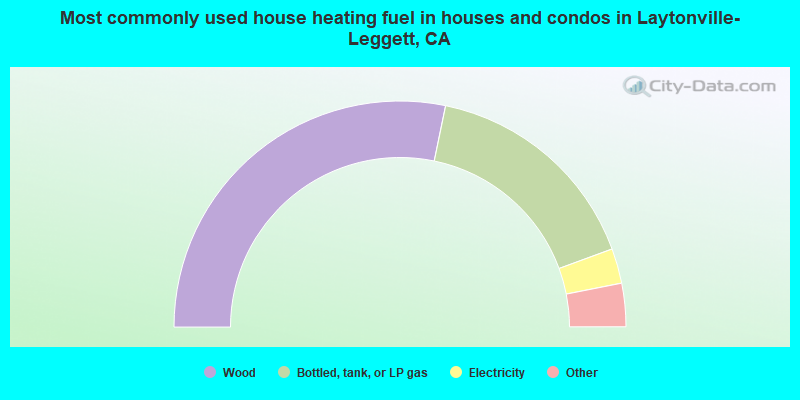
- 56.5%Wood
- 32.3%Bottled, tank, or LP gas
- 5.0%Electricity
- 2.6%Fuel oil, kerosene, etc.
- 1.5%Utility gas
- 1.3%Other fuel
- 0.6%Solar energy
- 0.2%No fuel used
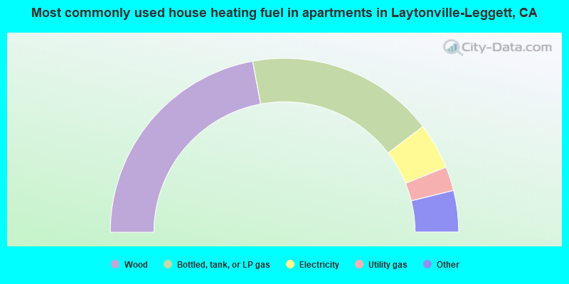
- 44.2%Wood
- 35.1%Bottled, tank, or LP gas
- 8.6%Electricity
- 4.5%Utility gas
- 3.8%Fuel oil, kerosene, etc.
- 2.2%Other fuel
- 1.7%No fuel used
Laytonville-Leggett compared to California state average:
- Median household income below state average.
- Median house value below state average.
- Black race population percentage significantly below state average.
- Hispanic race population percentage significantly below state average.
- Median age significantly above state average.
- Foreign-born population percentage significantly below state average.
- Length of stay since moving in significantly above state average.
- Number of rooms per house significantly below state average.
- House age significantly below state average.
State forum archive:
- California Pages: 2 3 4 5 6 7 8 9 10 11 12 13 14 15 16 17 18 19 20 21 22 23 24 25 26 27 28 29 30 31 32 33 34 35 36 37 38 39 40 41 42 43 44 45 46 47 48 49 50 51 52 53 54 55 56 57 58 59 60 61 62 63 64 65 66 67 68 69 70 71 72 73 74 75 76 77 78 79
- Los Angeles Pages: 2 3 4 5 6 7 8 9 10 11 12 13 14 15 16 17 18 19 20 21 22 23 24 25 26 27 28 29 30 31 32 33 34 35 36 37 38 39 40 41 42 43 44 45 46 47 48 49 50 51 52 53 54 55 56 57 58 59 60 61 62 63 64 65 66 67 68 69 70 71 72 73 74 75 76 77 78 79 80 81 82 83 84 85 86 87 88 89 90 91 92 93 94 95 96 97 98 99 100 101 102 103 104 105 106 107 108 109 110 111 112 113 114 115 116 117 118 119 120 121 122 123
- Monterey County Pages: 2 3
- Orange County Pages: 2 3 4 5 6 7 8 9 10 11 12 13 14 15 16 17 18 19 20 21 22 23 24 25 26 27 28 29 30 31 32 33 34 35 36
- Sacramento Pages: 2 3 4 5 6 7 8 9 10 11 12 13 14 15 16 17 18 19 20 21 22 23 24 25 26 27 28 29 30 31 32
- San Bernardino and Riverside Counties Pages: 2 3 4 5 6 7 8 9 10 11 12 13 14 15 16 17 18 19 20 21 22 23
- San Diego Pages: 2 3 4 5 6 7 8 9 10 11 12 13 14 15 16 17 18 19 20 21 22 23 24 25 26 27 28 29 30 31 32 33 34 35 36 37 38 39 40 41 42 43 44 45 46 47 48 49 50 51 52 53 54 55 56 57 58 59 60 61 62 63 64 65 66 67 68 69 70 71 72 73 74 75 76
- San Francisco - Oakland Pages: 2 3 4 5 6 7 8 9 10 11 12 13 14 15 16 17 18 19 20 21 22 23 24 25 26 27 28 29 30 31 32 33 34 35 36 37 38 39 40 41 42 43 44 45 46 47 48 49 50 51 52 53 54 55 56 57 58 59 60 61 62 63 64 65 66 67 68 69 70 71 72
- San Jose Pages: 2 3 4 5 6 7 8 9 10 11 12 13 14 15 16 17 18 19 20 21 22 23 24
- Ventura County Pages: 2 3 4 5 6 7