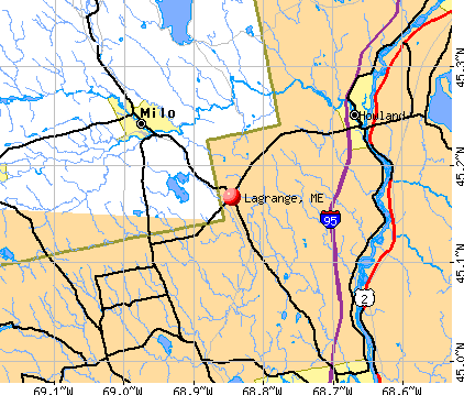
Lagrange, Maine
Submit your own pictures of this town and show them to the world
- OSM Map
- General Map
- Google Map
- MSN Map
Population change since 2000: -5.2%
 |
| Males: 364 | |
| Females: 344 |
| Median resident age: | 42.8 years |
| Maine median age: | 43.0 years |
Zip codes: 04453.
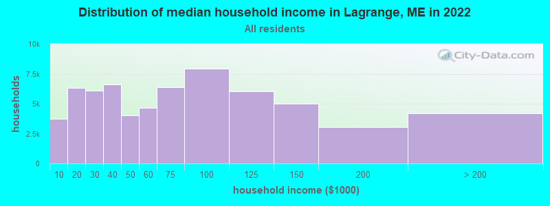
| Lagrange: | $59,388 |
| ME: | $69,543 |
Estimated per capita income in 2022: $27,627 (it was $13,743 in 2000)
Lagrange town income, earnings, and wages data
Estimated median house or condo value in 2022: $149,098 (it was $57,300 in 2000)
| Lagrange: | $149,098 |
| ME: | $290,600 |
Mean prices in 2022: all housing units: $235,563; detached houses: $252,705; townhouses or other attached units: $267,749; in 2-unit structures: $255,332; in 3-to-4-unit structures: $815,300; in 5-or-more-unit structures: $185,873; mobile homes: $93,017; occupied boats, rvs, vans, etc.: $21,333
Detailed information about poverty and poor residents in Lagrange, ME
Compare current foreclosures near Lagrange, ME:
| Photo | Address | Area | Beds / Baths | Price | Details |
|---|---|---|---|---|---|

|
#1
Howland Rd
Lagrange, ME 04453
|
- sq. feet
|
- baths - beds |
show details | |

|
#2
Upper Cross Rd
Hudson, ME 04449
|
1,344 sq. feet
|
2 baths 3 beds |
show details | |

|
#3
Main St
Corinth, ME 04427
|
1,573 sq. feet
|
2 baths 3 beds |
show details | |

|
#4
Lewis Trailer Park Rd
Milo, ME 04463
|
- sq. feet
|
- baths - beds |
show details | |

|
#5
Milo Rd
Sebec, ME 04481
|
- sq. feet
|
- baths - beds |
show details | |

|
#6
Range Rd
Dover Foxcroft, ME 04426
|
- sq. feet
|
- baths - beds |
show details | |

|
#7
Range Rd
Dover Foxcroft, ME 04426
|
- sq. feet
|
- baths - beds |
show details | |

|
#8
Morison Ave
Corinth, ME 04427
|
- sq. feet
|
- baths - beds |
show details | |

|
#9
Exeter Rd
Corinth, ME 04427
|
- sq. feet
|
- baths - beds |
show details | |

|
#10
Main Rd
West Enfield, ME 04493
|
- sq. feet
|
- baths - beds |
show details |
| Photo | Address | Area | Beds / Baths | Price | Details |
|---|---|---|---|---|---|

|
#11
Hudson Hill Rd
Hudson, ME 04449
|
- sq. feet
|
- baths - beds |
show details | |

|
#12
Hudson Rd
Hudson, ME 04449
|
- sq. feet
|
- baths - beds |
show details | |

|
#13
Greenfield Rd
Greenbush, ME 04418
|
- sq. feet
|
- baths - beds |
show details | |

|
#14
Cedar Breeze N
Bangor, ME 04401
|
- sq. feet
|
- baths - beds |
show details | |

|
Check over 1 million property listings on Foreclosure.com!
|
browse all offers | |||

- 68496.6%White alone
- 60.8%American Indian alone
- 60.8%Two or more races
- 60.8%Hispanic
- 40.6%Asian alone
- 20.3%Black alone
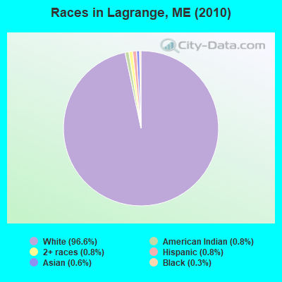
Races in Lagrange detailed stats: ancestries, foreign born residents, place of birth
According to our research of Maine and other state lists, there were 5 registered sex offenders living in Lagrange, Maine as of May 09, 2024.
The ratio of all residents to sex offenders in Lagrange is 142 to 1.
 Recent articles from our blog. Our writers, many of them Ph.D. graduates or candidates, create easy-to-read articles on a wide variety of topics.

 | Anyone from LaGrange/Three Rivers Community, ME here? (5 replies) |
| Woodsy Areas not too far from Bangor/Orono area (3 replies) |
| Is owning a gun in less populated areas of Maine advisable? (61 replies) |
| great hiking in Maine (51 replies) |
| Photos of Maine (4586 replies) |
| Welfare in Maine (123 replies) |
Latest news from Lagrange, ME collected exclusively by city-data.com from local newspapers, TV, and radio stations
Ancestries: English (15.8%), Irish (12.9%), French (10.3%), German (7.6%), United States (7.6%), Scotch-Irish (2.7%).
Current Local Time: EST time zone
Elevation: 314 feet
Land area: 49.4 square miles.
Population density: 14 people per square mile (very low).
| Lagrange town: | 1.2% ($681) |
| Maine: | 1.5% ($1,417) |
Nearest city with pop. 50,000+: Portland, ME  (125.6 miles , pop. 64,249).
Nearest city with pop. 200,000+: Boston, MA (226.6 miles , pop. 589,141).
Nearest city with pop. 1,000,000+: Bronx, NY (392.6 miles , pop. 1,332,650).
Nearest cities:
), ), ), Latitude: 45.16 N, Longitude: 68.82 W
Area code commonly used in this area: 207
| Here: | 5.0% |
| Maine: | 3.4% |
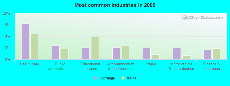
- Health care (15.5%)
- Public administration (6.1%)
- Educational services (5.3%)
- Accommodation & food services (5.3%)
- Paper (5.0%)
- Motor vehicle & parts dealers (5.0%)
- Finance & insurance (4.1%)
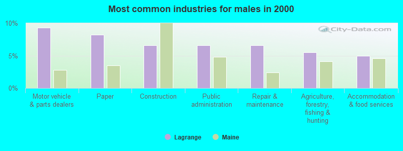
- Motor vehicle & parts dealers (9.3%)
- Paper (8.2%)
- Construction (6.6%)
- Public administration (6.6%)
- Repair & maintenance (6.6%)
- Agriculture, forestry, fishing & hunting (5.5%)
- Accommodation & food services (4.9%)
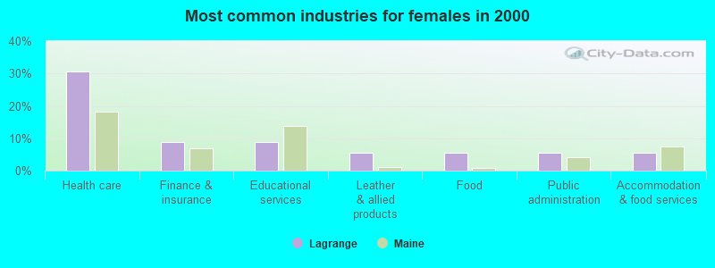
- Health care (30.6%)
- Finance & insurance (8.8%)
- Educational services (8.8%)
- Leather & allied products (5.6%)
- Food (5.6%)
- Public administration (5.6%)
- Accommodation & food services (5.6%)
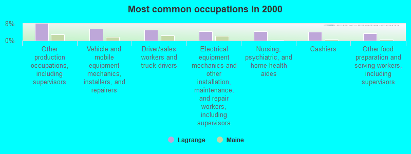
- Other production occupations, including supervisors (7.9%)
- Vehicle and mobile equipment mechanics, installers, and repairers (5.6%)
- Driver/sales workers and truck drivers (5.0%)
- Electrical equipment mechanics and other installation, maintenance, and repair workers, including supervisors (4.4%)
- Nursing, psychiatric, and home health aides (4.4%)
- Cashiers (4.1%)
- Other food preparation and serving workers, including supervisors (3.5%)
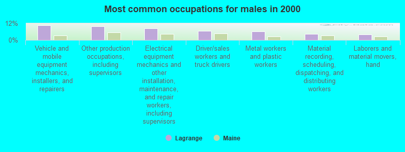
- Vehicle and mobile equipment mechanics, installers, and repairers (10.4%)
- Other production occupations, including supervisors (9.9%)
- Electrical equipment mechanics and other installation, maintenance, and repair workers, including supervisors (8.2%)
- Driver/sales workers and truck drivers (6.6%)
- Metal workers and plastic workers (6.0%)
- Material recording, scheduling, dispatching, and distributing workers (4.4%)
- Laborers and material movers, hand (3.8%)

- Cashiers (8.8%)
- Nursing, psychiatric, and home health aides (8.8%)
- Health technologists and technicians (7.5%)
- Other office and administrative support workers, including supervisors (6.2%)
- Other production occupations, including supervisors (5.6%)
- Information and record clerks, except customer service representatives (5.6%)
- Other food preparation and serving workers, including supervisors (5.0%)
Average climate in Lagrange, Maine
Based on data reported by over 4,000 weather stations


(lower is better)
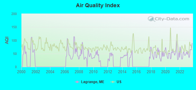
Air Quality Index (AQI) level in 2023 was 57.5. This is better than average.
| City: | 57.5 |
| U.S.: | 72.6 |
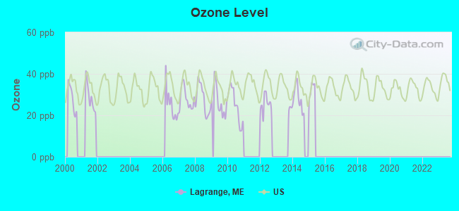
Ozone [ppb] level in 2015 was 16.3. This is significantly better than average. Closest monitor was 6.8 miles away from the city center.
| City: | 16.3 |
| U.S.: | 33.3 |
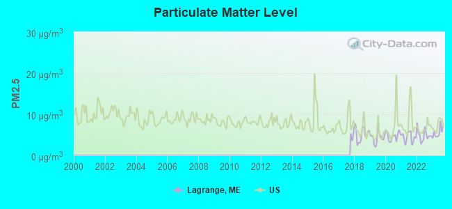
Particulate Matter (PM2.5) [µg/m3] level in 2023 was 5.62. This is significantly better than average. Closest monitor was 17.8 miles away from the city center.
| City: | 5.62 |
| U.S.: | 8.11 |
Earthquake activity:
Lagrange-area historical earthquake activity is significantly above Maine state average. It is 82% smaller than the overall U.S. average.On 4/20/2002 at 10:50:47, a magnitude 5.3 (5.3 ML, Depth: 3.0 mi, Class: Moderate, Intensity: VI - VII) earthquake occurred 243.2 miles away from the city center
On 10/16/2012 at 23:12:25, a magnitude 4.7 (4.7 ML, Depth: 10.0 mi, Class: Light, Intensity: IV - V) earthquake occurred 141.0 miles away from the city center
On 4/20/2002 at 10:50:47, a magnitude 5.2 (5.2 MB, 4.2 MS, 5.2 MW, 5.0 MW) earthquake occurred 244.6 miles away from the city center
On 10/7/1983 at 10:18:46, a magnitude 5.3 (5.1 MB, 5.3 LG, 5.1 ML) earthquake occurred 284.5 miles away from the city center
On 1/19/1982 at 00:14:42, a magnitude 4.7 (4.5 MB, 4.7 MD, 4.5 LG) earthquake occurred 179.0 miles away from the city center
On 2/26/1999 at 03:38:43, a magnitude 3.8 (3.8 LG, Depth: 2.0 mi, Class: Light, Intensity: II - III) earthquake occurred 58.1 miles away from Lagrange center
Magnitude types: regional Lg-wave magnitude (LG), body-wave magnitude (MB), duration magnitude (MD), local magnitude (ML), surface-wave magnitude (MS), moment magnitude (MW)
Natural disasters:
The number of natural disasters in Penobscot County (19) is greater than the US average (15).Major Disasters (Presidential) Declared: 11
Emergencies Declared: 7
Causes of natural disasters: Floods: 9, Storms: 8, Snows: 5, Heavy Rains: 2, Blizzard: 1, Hurricane: 1, Ice Storm: 1, Snowfall: 1, Wind: 1, Winter Storm: 1, Other: 2 (Note: some incidents may be assigned to more than one category).
Colleges/universities with over 2000 students nearest to Lagrange:
- University of Maine (about 20 miles; Orono, ME; Full-time enrollment: 8,931)
- Husson University (about 23 miles; Bangor, ME; FT enrollment: 2,421)
- University of Maine at Farmington (about 74 miles; Farmington, ME; FT enrollment: 2,036)
- University of Maine at Augusta (about 75 miles; Augusta, ME; FT enrollment: 3,204)
- Saint Joseph's College of Maine (about 124 miles; Standish, ME; FT enrollment: 2,010)
- Southern Maine Community College (about 126 miles; South Portland, ME; FT enrollment: 4,666)
- University of Southern Maine (about 126 miles; Portland, ME; FT enrollment: 6,647)
Points of interest:
Notable location: Lagrange Volunteer Fire Department (A). Display/hide its location on the map
Streams, rivers, and creeks: Tenmile Brook (A), Rawlins Brook (B). Display/hide their locations on the map
Drinking water stations with addresses in Lagrange and their reported violations in the past:
MSAD 31 ENFIELD STATION ELEMENTARY (Population served: 300, Groundwater):Past health violations:MSAD 41 BROWNVILLE ELEM SCHOOL (Population served: 157, Groundwater):Past monitoring violations:
- MCL, Monthly (TCR) - In JAN-2014, Contaminant: Coliform. Follow-up actions: St Public Notif requested (JAN-21-2014), St Formal NOV issued (JAN-21-2014), St Compliance achieved (FEB-20-2014), St Public Notif received (MAR-25-2014)
- MCL, Monthly (TCR) - In DEC-2013, Contaminant: Coliform. Follow-up actions: St Public Notif requested (DEC-20-2013), St Formal NOV issued (DEC-20-2013), St Public Notif received (JAN-21-2014), St Compliance achieved (FEB-20-2014)
- MCL, Monthly (TCR) - In DEC-2011, Contaminant: Coliform. Follow-up actions: St Public Notif requested (JAN-20-2012), St Formal NOV issued (JAN-20-2012), St Public Notif received (JAN-27-2012), St Compliance achieved (FEB-14-2012)
- MCL, Monthly (TCR) - Between JUL-2006 and SEP-2006, Contaminant: Coliform. Follow-up actions: St Violation/Reminder Notice (SEP-21-2006), St Public Notif requested (SEP-21-2006), St Public Notif received (OCT-02-2006), St Compliance achieved (APR-18-2008)
- OCCT/SOWT Study/Recommendation - In JUN-02-2005, Contaminant: Lead and Copper Rule. Follow-up actions: St Violation/Reminder Notice (JUL-19-2006), St Public Notif requested (JUL-19-2006), St Compliance achieved (OCT-23-2009), St Intentional no-action (AUG-18-2011)
- One routine major monitoring violation
Past monitoring violations:TOWN HALL APTS - LAGRANGE (Population served: 60, Groundwater):
- Follow-up Or Routine LCR Tap M/R - In OCT-01-2011, Contaminant: Lead and Copper Rule. Follow-up actions: St Public Notif requested (JAN-12-2012), St Formal NOV issued (JAN-12-2012), St Compliance achieved (JUL-30-2012), St Public Notif received (MAR-05-2013)
- One routine major monitoring violation
Past health violations:MSAD 41 MARION C COOK SCHOOL (Population served: 50, Groundwater):
- MCL, Monthly (TCR) - In AUG-2009, Contaminant: Coliform. Follow-up actions: St Public Notif requested (AUG-18-2009), St Formal NOV issued (AUG-18-2009), St Public Notif received (AUG-25-2009), St Compliance achieved (JUL-01-2010)
Past health violations:Past monitoring violations:
- MCL, Monthly (TCR) - In SEP-2008, Contaminant: Coliform. Follow-up actions: St Public Notif requested (SEP-16-2008), St Formal NOV issued (SEP-16-2008), St Public Notif received (SEP-25-2008), St Compliance achieved (JUN-23-2010)
- One routine major monitoring violation
| This town: | 2.4 people |
| Maine: | 2.3 people |
| This town: | 63.4% |
| Whole state: | 62.9% |
| This town: | 9.1% |
| Whole state: | 9.4% |
Likely homosexual households (counted as self-reported same-sex unmarried-partner households)
- Lesbian couples: 0.3% of all households
- Gay men: 0.7% of all households
| This town: | 17.0% |
| Whole state: | 10.9% |
| This town: | 6.4% |
| Whole state: | 4.1% |
For population 15 years and over in Lagrange:
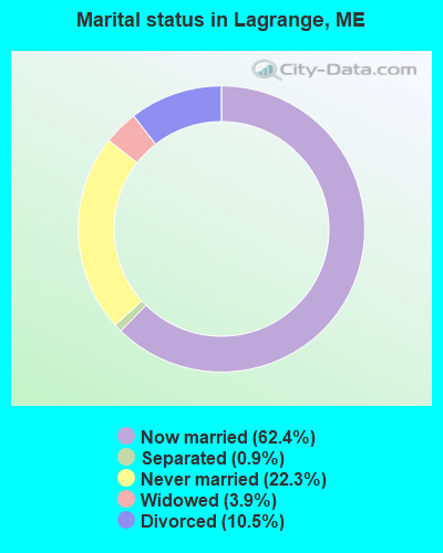
- Never married: 22.3%
- Now married: 62.4%
- Separated: 0.9%
- Widowed: 3.9%
- Divorced: 10.5%
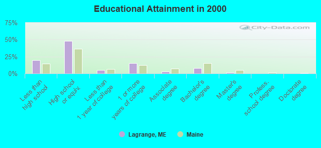
For population 25 years and over in Lagrange:
- High school or higher: 80.7%
- Bachelor's degree or higher: 9.6%
- Graduate or professional degree: 1.5%
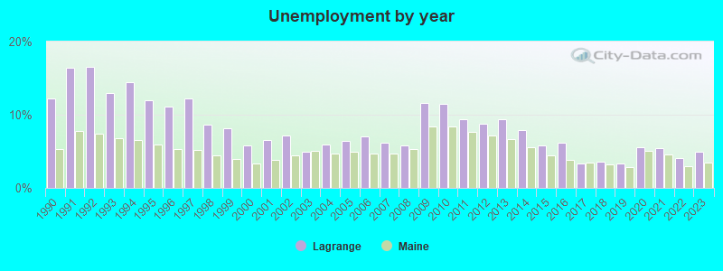
- Unemployed: 6.0%
- Mean travel time to work (commute): 35.0 minutes
| Here: | 9.4 |
| Maine average: | 11.2 |


Graphs represent county-level data. Detailed 2008 Election Results
Religion statistics for Lagrange, ME (based on Penobscot County data)


| Religion | Adherents | Congregations |
|---|---|---|
| Catholic | 16,581 | 15 |
| Mainline Protestant | 9,715 | 59 |
| Evangelical Protestant | 7,523 | 80 |
| Other | 2,936 | 22 |
| Orthodox | 300 | 1 |
| None | 116,868 | - |
Food Environment Statistics:
| Penobscot County: | 2.29 / 10,000 pop. |
| State: | 2.80 / 10,000 pop. |
| Here: | 0.13 / 10,000 pop. |
| Maine: | 0.14 / 10,000 pop. |
| Penobscot County: | 2.56 / 10,000 pop. |
| Maine: | 2.20 / 10,000 pop. |
| Penobscot County: | 5.72 / 10,000 pop. |
| Maine: | 5.75 / 10,000 pop. |
| Here: | 7.41 / 10,000 pop. |
| Maine: | 11.02 / 10,000 pop. |
| Penobscot County: | 9.0% |
| Maine: | 8.2% |
| Penobscot County: | 28.0% |
| State: | 25.0% |
Strongest AM radio stations in Lagrange:
- WZON (620 AM; 5 kW; BANGOR, ME; Owner: THE ZONE CORPORATION)
- WABI (910 AM; 5 kW; BANGOR, ME; Owner: CLEAR CHANNEL BROADCASTING LICENSES, INC.)
- WSKW (1160 AM; 10 kW; SKOWHEGAN, ME; Owner: MOUNTAIN WIRELESS, INCORPORATED)
- WNZS (1340 AM; 1 kW; VEAZIE, ME; Owner: WATERFRONT COMMUNICATIONS INC.)
- WRKO (680 AM; 50 kW; BOSTON, MA; Owner: ENTERCOM BOSTON LICENSE, LLC)
- WDEA (1370 AM; 5 kW; ELLSWORTH, ME; Owner: CUMULUS LICENSING CORP.)
- WTME (780 AM; 10 kW; RUMFORD, ME; Owner: MOUNTAIN VALLEY BROADCASTING, INC.)
- WEEI (850 AM; 50 kW; BOSTON, MA; Owner: ENTERCOM BOSTON LICENSE, LLC)
- WBZ (1030 AM; 50 kW; BOSTON, MA; Owner: INFINITY BROADCASTING OPERATIONS, INC.)
- WNNZ (640 AM; 50 kW; WESTFIELD, MA; Owner: CLEAR CHANNEL BROADCASTING LICENSES, INC.)
- WCRN (830 AM; 50 kW; WORCESTER, MA; Owner: CARTER BROADCASTING CORPORATION)
- WCHP (760 AM; 35 kW; CHAMPLAIN, NY; Owner: CHAMPLAIN RADIO, INC.)
- WREM (710 AM; daytime; 5 kW; MONTICELLO, ME; Owner: ALLAN H WEINER)
Strongest FM radio stations in Lagrange:
- WVOM (103.9 FM; HOWLAND, ME; Owner: CLEAR CHANNEL BROADCASTING LICENSES, INC.)
- WHCF (88.5 FM; BANGOR, ME; Owner: BANGOR BAPTIST CHURCH)
- WBZN (107.3 FM; OLD TOWN, ME; Owner: CUMULUS LICENSING CORP.)
- WQCB (106.5 FM; BREWER, ME; Owner: CUMULUS LICENSING CORP.)
- WWBX (97.1 FM; BANGOR, ME; Owner: CLEAR CHANNEL BROADCASTING LICENSES, INC.)
- WGUY (102.1 FM; DEXTER, ME; Owner: CONCORD MEDIA GROUP, INC.)
- WMEH (90.9 FM; BANGOR, ME; Owner: MAINE PUBLIC BROADCASTING CORPORATION)
- WWMJ (95.7 FM; ELLSWORTH, ME; Owner: CUMULUS LICENSING CORP.)
- WHMX (105.7 FM; LINCOLN, ME; Owner: BANGOR BAPTIST CHURCH)
- WEZQ (92.9 FM; BANGOR, ME; Owner: CUMULUS LICENSING CORP.)
- WKIT-FM (100.3 FM; BREWER, ME; Owner: THE ZONE CORPORATION)
- WBFB (104.7 FM; BELFAST, ME; Owner: CLEAR CHANNEL BROADCASTING LICENSES, INC.)
- WDME-FM (103.1 FM; DOVER-FOXCROFT, ME; Owner: THE ZONE CORPORATION)
- WMEB-FM (91.9 FM; ORONO, ME; Owner: UNIVERSITY OF MAINE SYSTEM)
Medal of Honor Recipients
Medal of Honor Recipient born in Lagrange: Abiather J. Knowles.
- Lagrange, Maine
- Fatal accident count9
- Vehicles involved in fatal accidents9
- Fatal accidents involving drunk persons:6
- Fatalities9
- Persons involved in fatal accidents15
- Pedestrians involved in fatal accidents0
- Maine average
- Fatal accident count1506
- Vehicles involved in fatal accidents2127
- Fatal accidents involving drunk persons632
- Fatalities1650
- Persons involved in fatal accidents3557
- Pedestrians involved in fatal accidents87
- National Bridge Inventory (NBI) Statistics
- 1Number of bridges
- 3ft / 0.7mTotal length
- 738Total average daily traffic
- 36Total average daily truck traffic
- 1,181Total future (year 2036) average daily traffic
FCC Registered Cell Phone Towers:
1- (Lagrange Site) Weymouth Drive (Lat: 45.239722 Lon: -68.776944), Type: Tower, Structure height: 91.4 m, Overall height: 96 m, Call Sign: KNKA726
Assigned Frequencies: 880.020 MHz, 880.020 MHz, 835.020 MHz, 835.020 MHz, 891.510 MHz, 891.510 MHz, 846.510 MHz, 846.510 MHz, 880.020 MHz, 835.020 MHz, 891.510 MHz, 846.510 MHzGrant Date: 12/19/2017, Expiration Date: 01/22/2028, Certifier: John T Scott IiiRegistrant: Verizon Wireless, 5055 North Point Pkwy, Np2ne Network Engineering, Alpharetta, GA 30022, Phone: (770) 797-1070, Fax: (678) 259-1319, Email:
FCC Registered Antenna Towers:
5- Mark L Gartley, Weymouth Drive (Lat: 45.239722 Lon: -68.776944), Type: 96.0, Overall height: 91.4 m, Registrant: Holland & Knight LLP, Pconnolly@hklaw.Com, , Washi-ngton, Phone: (202) 862-5989
- Mark L Gartley, Weymouth Drive (Lat: 45.239722 Lon: -68.776944), Type: 96.0, Overall height: 91.4 m, Registrant: Holland & Knight LLP, Pconnolly@hklaw.Com, , Washi-ngton, Phone: (202) 862-5989
- STEVEN T CAMPBELL, Weymouth Drive (Lat: 45.239722 Lon: -68.776944), Type: 96.0, Structure height: 23019 m, Overall height: 91.4 m, Registrant: Holland & Knight LLP, Peter.Connolly@hklaw.Com, , Washi-ngton, Phone: (202) 955-3000
- Cayla Gamble, Weymouth Drive (Lat: 45.239722 Lon: -68.776944), Type: 96.0, Structure height: 23019 m, Overall height: 91.4 m, Registrant: Holland & Knight LLP, Peter.Connolly@hklaw.Com, , Washi-ngton, Phone: (202) 955-3000
- Cayla Gamble, Weymouth Drive (Lat: 45.239722 Lon: -68.776944), Type: 96.0, Structure height: 23019 m, Overall height: 91.4 m, Registrant: Holland & Knight LLP, Peter.Connolly@hklaw.Com, , Washi-ngton, Phone: (202) 955-3000
FCC Registered Microwave Towers:
2- HOWLAND_USF, Weymouth Drive (Lat: 45.239722 Lon: -68.776944), Type: Gtower, Structure height: 91.4 m, Overall height: 96 m, Call Sign: WQIB351,
Assigned Frequencies: 6123.10 MHz, 5974.85 MHz, Grant Date: 12/05/2017, Expiration Date: 12/18/2027, Certifier: John E Rooney, Registrant: Wilkinson Barker Knauer, LLP, 1800 M Street Nw, Suite 800n, Washington, DC 20036, Phone: (202) 383-3420, Fax: (202) 783-5851, Email:
- LAGRANGE, Weymouth Drive (Lat: 45.239722 Lon: -68.776944), Type: Gtower, Structure height: 91.4 m, Overall height: 96 m, Call Sign: WQRD260,
Assigned Frequencies: 11245.0 MHz, Grant Date: 04/18/2013, Expiration Date: 04/18/2023, Cancellation Date: 03/13/2015, Certifier: Charles Cleary, Registrant: Verizon Wireless, 1120 Sanctuary Pkwy, #150 Gasa5reg, Alpharetta, GA 30009-7630, Phone: (770) 797-1070, Fax: (770) 797-1036, Email:
FCC Registered Amateur Radio Licenses:
6- Call Sign: AA1AQ, Previous Call Sign: KA1DHY, Licensee ID: L00762640, Grant Date: 11/06/2003, Expiration Date: 11/09/2013, Cancellation Date: 11/11/2015, Certifier: Reynold J Moreau, Registrant: Reynold J Moreau, 5356 Bennoch Rd, Lagrange, ME 04453
- Call Sign: KC1JK, Previous Call Sign: KA1DHW, Licensee ID: L00764825, Grant Date: 11/06/2003, Expiration Date: 11/09/2013, Cancellation Date: 11/11/2015, Certifier: Elizabeth F Ames, Registrant: Elizabeth F Ames, 5356 Bennoch Rd, Lagrange, ME 04453
- Call Sign: N1PHA, Licensee ID: L00709914, Grant Date: 07/01/2003, Expiration Date: 06/01/2013, Cancellation Date: 06/02/2015, Certifier: Frances F Robertson, Registrant: Frances F Robertson, 306 Medford Road, Lagrange, ME 04453
- Call Sign: KB1LCE, Licensee ID: L00839880, Grant Date: 03/25/2014, Expiration Date: 03/31/2024, Certifier: Glenn W Sanborn, Registrant: Glenn W Sanborn, Lagrange, ME 04453
- Call Sign: KB1LDF, Licensee ID: L00842551, Grant Date: 03/25/2014, Expiration Date: 04/06/2024, Certifier: Inez Sanborn, Registrant: Inez Sanborn, Lagrange, ME 04453
- Call Sign: KB1ZQU, Licensee ID: L01779752, Grant Date: 04/09/2013, Expiration Date: 04/09/2023, Certifier: Annette J Ezrow, Registrant: Annette J Ezrow, 197 Medford Rd, Lagrange, ME 04453
FAA Registered Aircraft:
1- Aircraft: CESSNA 150G (Category: Land, Seats: 2, Weight: Up to 12,499 Pounds, Speed: 90 mph), Engine: CONT MOTOR 0-200 SERIES (100 HP) (4 Cycle)
N-Number: 3081S, N3081S, N-3081S, Serial Number: 15066981, Year manufactured: 1967, Airworthiness Date: 07/17/1967, Certificate Issue Date: 02/11/2014
Registrant (Partnership): Reginald H Trefts, 138 Mill St, Lagrange, ME 04453, Other Owners: Roberta L Trefts
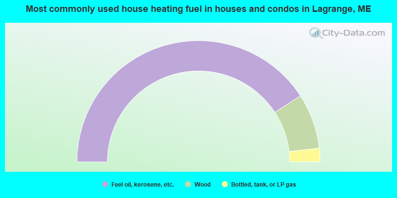
- 81.7%Fuel oil, kerosene, etc.
- 14.7%Wood
- 3.6%Bottled, tank, or LP gas
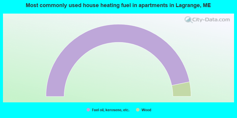
- 93.5%Fuel oil, kerosene, etc.
- 6.5%Wood
Lagrange compared to Maine state average:
- Median house value below state average.
- Unemployed percentage below state average.
- Black race population percentage significantly below state average.
- Hispanic race population percentage below state average.
- Foreign-born population percentage significantly below state average.
- Length of stay since moving in significantly above state average.
- Number of rooms per house significantly below state average.
- House age significantly below state average.
- Number of college students below state average.
- Percentage of population with a bachelor's degree or higher significantly below state average.