Knox, New York
Submit your own pictures of this town and show them to the world
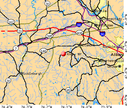
- OSM Map
- General Map
- Google Map
- MSN Map
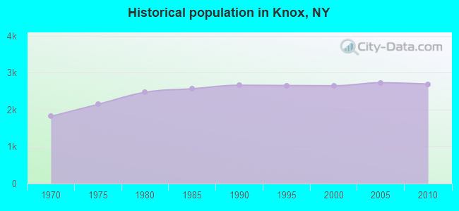
Population change since 2000: +1.7%
 |
| Males: 1,367 | |
| Females: 1,325 |
| Median resident age: | 43.7 years |
| New York median age: | 40.7 years |
Zip codes: 12009.
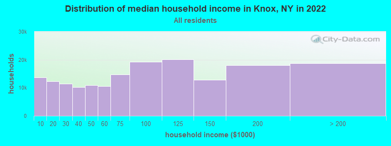
| Knox: | $99,881 |
| NY: | $79,557 |
Estimated per capita income in 2022: $43,691 (it was $22,670 in 2000)
Knox town income, earnings, and wages data
Estimated median house or condo value in 2022: $274,125 (it was $113,400 in 2000)
| Knox: | $274,125 |
| NY: | $400,400 |
Mean prices in 2022: all housing units: $311,969; detached houses: $333,344; townhouses or other attached units: $251,700; in 2-unit structures: $215,501; in 3-to-4-unit structures: $169,123; in 5-or-more-unit structures: $355,917; mobile homes: $192,367
Detailed information about poverty and poor residents in Knox, NY


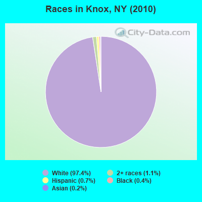
- 2,62397.4%White alone
- 291.1%Two or more races
- 200.7%Hispanic
- 120.4%Black alone
- 60.2%Asian alone
- 10.04%American Indian alone
- 10.04%Other race alone
Races in Knox detailed stats: ancestries, foreign born residents, place of birth
 Recent articles from our blog. Our writers, many of them Ph.D. graduates or candidates, create easy-to-read articles on a wide variety of topics.

 | Neighborhood revitalization/gentrification (186 replies) |
| Possibly relocating with family to Albany area- questions (3 replies) |
| Berne-Knox Areas (2 replies) |
| Thinking of Moving to the Saratoga Region (11 replies) |
| Moving to Watervliet/Albany area (80 replies) |
| Where should I look ? (10 replies) |
Latest news from Knox, NY collected exclusively by city-data.com from local newspapers, TV, and radio stations
Ancestries: German (24.1%), Irish (23.7%), English (15.2%), Dutch (10.9%), Italian (9.1%), French (7.8%).
Current Local Time: EST time zone
Land area: 41.8 square miles.
Population density: 64 people per square mile (very low).
30 residents are foreign born
| This town: | 1.1% |
| New York: | 20.4% |
| Knox town: | 1.7% ($1,982) |
| New York: | 1.9% ($2,847) |
Nearest city with pop. 50,000+: Schenectady, NY  (11.9 miles , pop. 61,821).
Nearest city with pop. 200,000+: Bronx, NY (128.0 miles , pop. 1,332,650).
Nearest cities:
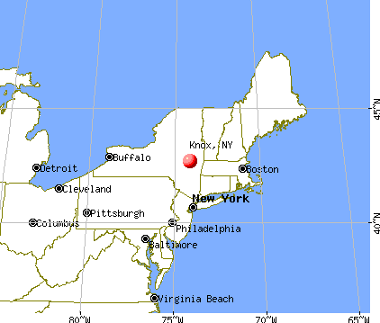
), ), ), ), ), ), Latitude: 42.69 N, Longitude: 74.10 W
Area code commonly used in this area: 518

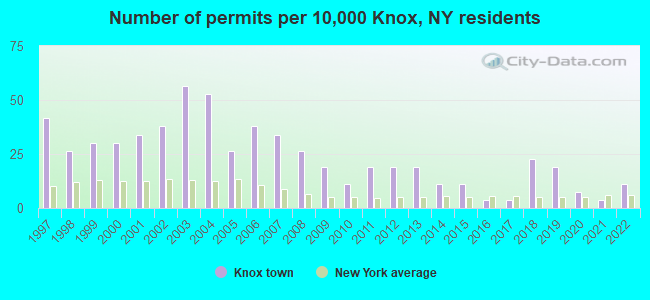
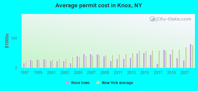
Single-family new house construction building permits:
- 2022: 3 buildings, average cost: $405,300
- 2021: 1 building, cost: $130,000
- 2020: 2 buildings, average cost: $170,000
- 2019: 5 buildings, average cost: $231,000
- 2018: 6 buildings, average cost: $310,000
- 2017: 1 building, cost: $72,000
- 2016: 1 building, cost: $222,000
- 2015: 3 buildings, average cost: $256,700
- 2014: 3 buildings, average cost: $245,000
- 2013: 5 buildings, average cost: $169,200
- 2012: 5 buildings, average cost: $156,200
- 2011: 5 buildings, average cost: $156,200
- 2010: 3 buildings, average cost: $119,700
- 2009: 5 buildings, average cost: $195,400
- 2008: 7 buildings, average cost: $231,400
- 2007: 9 buildings, average cost: $234,500
- 2006: 10 buildings, average cost: $234,500
- 2005: 7 buildings, average cost: $200,000
- 2004: 14 buildings, average cost: $83,200
- 2003: 15 buildings, average cost: $119,900
- 2002: 10 buildings, average cost: $115,900
- 2001: 9 buildings, average cost: $115,900
- 2000: 8 buildings, average cost: $150,800
- 1999: 8 buildings, average cost: $150,800
- 1998: 7 buildings, average cost: $137,100
- 1997: 11 buildings, average cost: $84,300
| Here: | 3.6% |
| New York: | 4.4% |
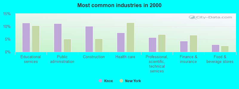
- Educational services (11.3%)
- Public administration (11.1%)
- Construction (10.1%)
- Health care (7.5%)
- Professional, scientific, technical services (5.7%)
- Finance & insurance (4.2%)
- Food & beverage stores (2.9%)
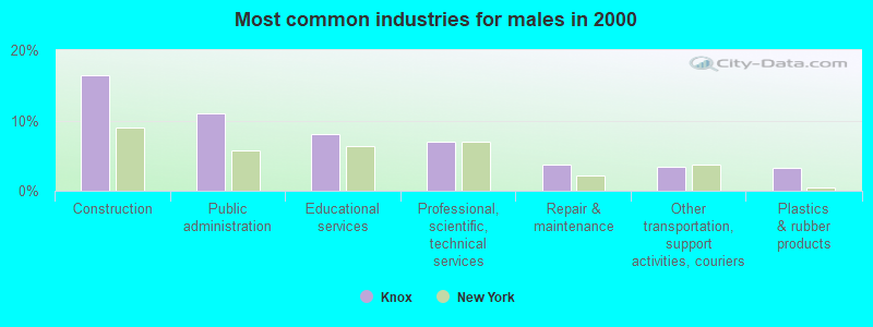
- Construction (16.4%)
- Public administration (11.1%)
- Educational services (8.0%)
- Professional, scientific, technical services (7.0%)
- Repair & maintenance (3.8%)
- Other transportation, support activities, couriers (3.4%)
- Plastics & rubber products (3.2%)
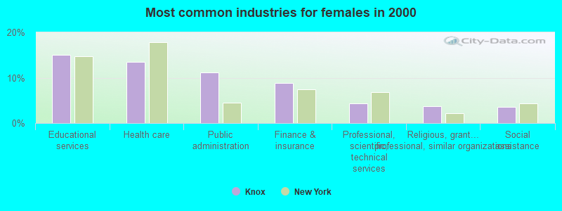
- Educational services (15.0%)
- Health care (13.5%)
- Public administration (11.2%)
- Finance & insurance (8.9%)
- Professional, scientific, technical services (4.3%)
- Religious, grantmaking, civic, professional, similar organizations (3.7%)
- Social assistance (3.5%)

- Secretaries and administrative assistants (4.5%)
- Other office and administrative support workers, including supervisors (4.3%)
- Other management occupations, except farmers and farm managers (3.7%)
- Other production occupations, including supervisors (3.6%)
- Electrical equipment mechanics and other installation, maintenance, and repair workers, including supervisors (3.2%)
- Retail sales workers, except cashiers (3.1%)
- Other sales and related occupations, including supervisors (3.1%)
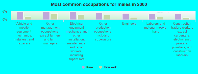
- Vehicle and mobile equipment mechanics, installers, and repairers (5.8%)
- Other management occupations, except farmers and farm managers (5.5%)
- Electrical equipment mechanics and other installation, maintenance, and repair workers, including supervisors (5.5%)
- Other production occupations, including supervisors (5.3%)
- Engineers (4.5%)
- Laborers and material movers, hand (4.3%)
- Construction traders workers except carpenters, electricians, painters, plumbers, and construction laborers (4.2%)
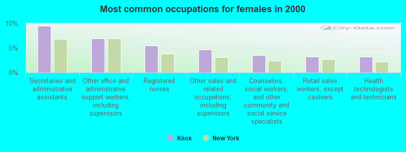
- Secretaries and administrative assistants (9.5%)
- Other office and administrative support workers, including supervisors (6.9%)
- Registered nurses (5.5%)
- Other sales and related occupations, including supervisors (4.6%)
- Counselors, social workers, and other community and social service specialists (3.5%)
- Retail sales workers, except cashiers (3.2%)
- Health technologists and technicians (3.2%)
Average climate in Knox, New York
Based on data reported by over 4,000 weather stations


(lower is better)
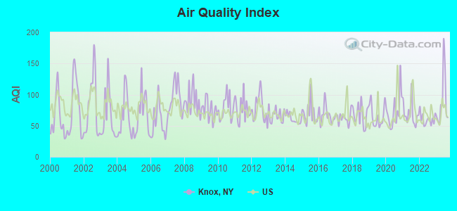
Air Quality Index (AQI) level in 2023 was 89.2. This is worse than average.
| City: | 89.2 |
| U.S.: | 72.6 |
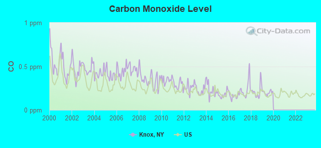
Carbon Monoxide (CO) [ppm] level in 2019 was 0.199. This is better than average. Closest monitor was 11.3 miles away from the city center.
| City: | 0.199 |
| U.S.: | 0.251 |
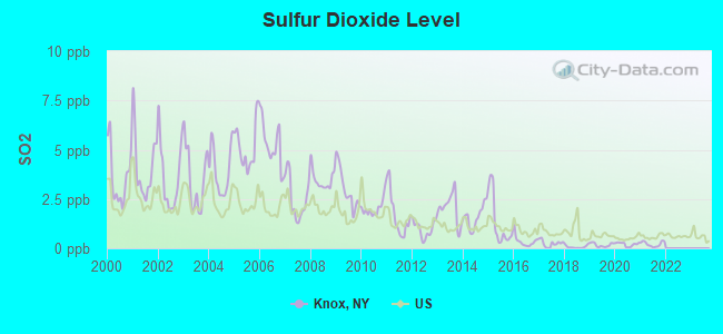
Sulfur Dioxide (SO2) [ppb] level in 2021 was 0.213. This is significantly better than average. Closest monitor was 11.3 miles away from the city center.
| City: | 0.213 |
| U.S.: | 1.515 |
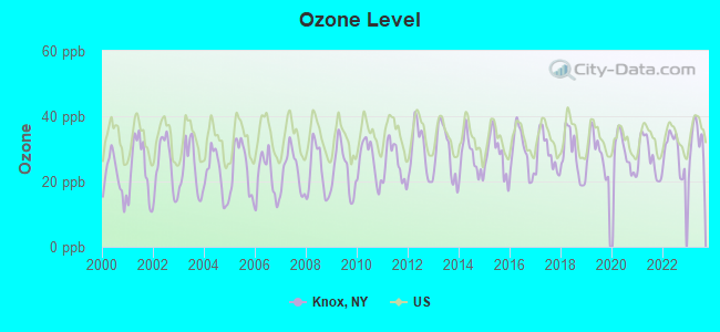
Ozone [ppb] level in 2023 was 32.1. This is about average. Closest monitor was 11.3 miles away from the city center.
| City: | 32.1 |
| U.S.: | 33.3 |
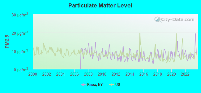
Particulate Matter (PM2.5) [µg/m3] level in 2023 was 9.66. This is about average. Closest monitor was 11.3 miles away from the city center.
| City: | 9.66 |
| U.S.: | 8.11 |
Tornado activity:
Knox-area historical tornado activity is slightly above New York state average. It is 52% smaller than the overall U.S. average.
On 7/10/1989, a category F4 (max. wind speeds 207-260 mph) tornado 21.7 miles away from the Knox town center injured 20 people and caused between $5,000,000 and $50,000,000 in damages.
On 6/24/1960, a category F3 (max. wind speeds 158-206 mph) tornado 13.7 miles away from the town center injured 9 people and caused between $5,000,000 and $50,000,000 in damages.
Earthquake activity:
Knox-area historical earthquake activity is significantly above New York state average. It is 67% smaller than the overall U.S. average.On 10/7/1983 at 10:18:46, a magnitude 5.3 (5.1 MB, 5.3 LG, 5.1 ML, Class: Moderate, Intensity: VI - VII) earthquake occurred 88.2 miles away from Knox center
On 4/20/2002 at 10:50:47, a magnitude 5.3 (5.3 ML, Depth: 3.0 mi) earthquake occurred 127.7 miles away from the city center
On 4/20/2002 at 10:50:47, a magnitude 5.2 (5.2 MB, 4.2 MS, 5.2 MW, 5.0 MW) earthquake occurred 125.8 miles away from the city center
On 1/19/1982 at 00:14:42, a magnitude 4.7 (4.5 MB, 4.7 MD, 4.5 LG, Class: Light, Intensity: IV - V) earthquake occurred 138.3 miles away from the city center
On 6/17/1991 at 08:53:16, a magnitude 4.1 (4.0 MB, 4.0 LG, Depth: 3.1 mi) earthquake occurred 29.5 miles away from the city center
On 10/16/2012 at 23:12:25, a magnitude 4.7 (4.7 ML, Depth: 10.0 mi) earthquake occurred 184.9 miles away from Knox center
Magnitude types: regional Lg-wave magnitude (LG), body-wave magnitude (MB), duration magnitude (MD), local magnitude (ML), surface-wave magnitude (MS), moment magnitude (MW)
Natural disasters:
The number of natural disasters in Albany County (20) is greater than the US average (15).Major Disasters (Presidential) Declared: 10
Emergencies Declared: 9
Causes of natural disasters: Hurricanes: 4, Storms: 4, Winter Storms: 4, Floods: 3, Snowstorms: 3, Blizzards: 2, Power Outage: 1, Tropical Storm: 1, Other: 2 (Note: some incidents may be assigned to more than one category).

Hospitals and medical centers near Knox:
- THE DUTCH MANOR NURSING AND REHAB CENTRE (Nursing Home, about 12 miles away; SCHENECTADY, NY)
- THE AVENUE NURSING AND REHAB CENTRE (Nursing Home, about 12 miles away; SCHENECTADY, NY)
- KINGSWAY ARMS NURSING CENTER INC (Nursing Home, about 12 miles away; SCHENECTADY, NY)
- VNS OF SCHENECTADY AND SARATOGA COUNTIES (Home Health Center, about 12 miles away; SCHENECTADY, NY)
- EDDY SENIORCARE LTHHCP (Home Health Center, about 12 miles away; SCHENECTADY, NY)
- SCHENECTADY COUNTY PUBLIC HEALTH SERVICES (Home Health Center, about 13 miles away; SCHENECTADY, NY)
- CAPITAL DISTRICT DDSO - O D HE (Hospital, about 13 miles away; SCHENECTADY, NY)
Airports located in Knox:
- West Township Airport (6NY4) (Runways: 1)
Amtrak stations near Knox:
- 12 miles: SCHENECTADY (332 ERIE BLVD.) . Services: ticket office, fully wheelchair accessible, enclosed waiting area, public restrooms, public payphones, vending machines, ATM, free short-term parking, free long-term parking, call for car rental service, taxi stand, public transit connection.
- 19 miles: AMSTERDAM (RAILROAD & W. MAIN STS.) . Services: enclosed waiting area, public restrooms, public payphones, free short-term parking, free long-term parking, call for car rental service, call for taxi service, public transit connection.
- 19 miles: ALBANY-RENSSELAER (RENSSELAER, 555 EAST ST.) . Services: ticket office, partially wheelchair accessible, enclosed waiting area, public restrooms, public payphones, snack bar, ATM, free short-term parking, free long-term parking, call for car rental service, taxi stand, public transit connection.
Colleges/universities with over 2000 students nearest to Knox:
- Schenectady County Community College (about 12 miles; Schenectady, NY; Full-time enrollment: 3,676)
- Excelsior College (about 13 miles; Albany, NY; FT enrollment: 4,723)
- Union College (about 13 miles; Schenectady, NY; FT enrollment: 2,075)
- SUNY at Albany (about 15 miles; Albany, NY; FT enrollment: 15,490)
- The College of Saint Rose (about 17 miles; Albany, NY; FT enrollment: 4,085)
- Siena College (about 18 miles; Loudonville, NY; FT enrollment: 3,153)
- SUNY College of Agriculture and Technology at Cobleskill (about 21 miles; Cobleskill, NY; FT enrollment: 2,455)
Points of interest:
Notable location: Camp Altamont (A). Display/hide its location on the map
Church in Knox: Lee Church (A). Display/hide its location on the map
Cemeteries: Snyder Cemetery (1), Ostrander Cemetery (2), High Point Cemetery (3). Display/hide their locations on the map
Lakes and reservoirs: Thompsons Lake (A), Altamont Reservoir (B). Display/hide their locations on the map
Creek: Wolf Creek (A). Display/hide its location on the map
| This town: | 2.6 people |
| New York: | 2.6 people |
| This town: | 75.5% |
| Whole state: | 63.5% |
| This town: | 8.4% |
| Whole state: | 6.8% |
Likely homosexual households (counted as self-reported same-sex unmarried-partner households)
- Lesbian couples: 0.7% of all households
- Gay men: 0.0% of all households
| This town: | 5.4% |
| Whole state: | 14.6% |
| This town: | 2.3% |
| Whole state: | 7.4% |
For population 15 years and over in Knox:
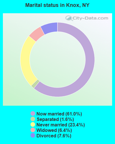
- Never married: 23.4%
- Now married: 61.0%
- Separated: 1.6%
- Widowed: 6.4%
- Divorced: 7.6%
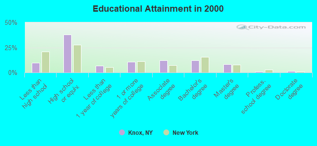
For population 25 years and over in Knox:
- High school or higher: 90.2%
- Bachelor's degree or higher: 22.9%
- Graduate or professional degree: 11.0%
- Unemployed: 5.1%
- Mean travel time to work (commute): 33.9 minutes
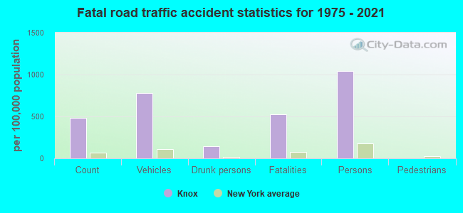
| Here: | 10.2 |
| New York average: | 14.2 |
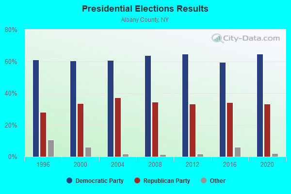
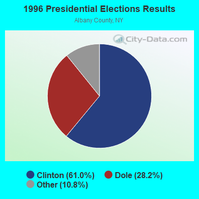
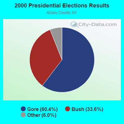
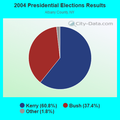
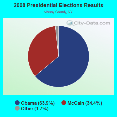
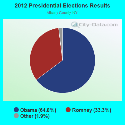
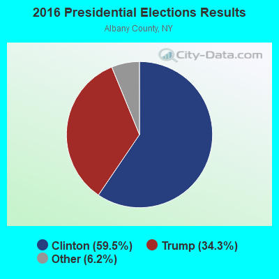
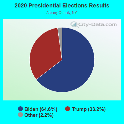
Graphs represent county-level data. Detailed 2008 Election Results
Religion statistics for Knox, NY (based on Albany County data)
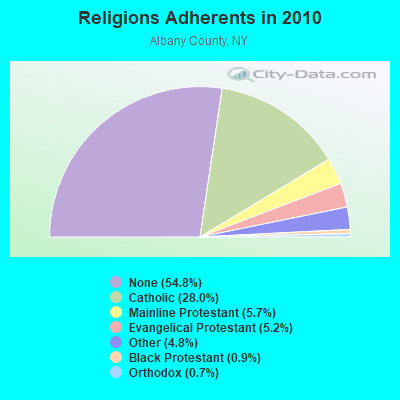
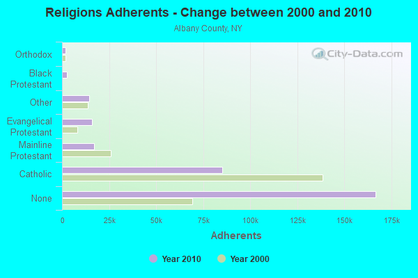
| Religion | Adherents | Congregations |
|---|---|---|
| Catholic | 85,267 | 29 |
| Mainline Protestant | 17,188 | 78 |
| Evangelical Protestant | 15,873 | 72 |
| Other | 14,472 | 31 |
| Black Protestant | 2,739 | 11 |
| Orthodox | 2,025 | 9 |
| None | 166,640 | - |
Food Environment Statistics:
| Albany County: | 2.51 / 10,000 pop. |
| New York: | 4.13 / 10,000 pop. |
| Here: | 0.07 / 10,000 pop. |
| New York: | 0.06 / 10,000 pop. |
| This county: | 1.07 / 10,000 pop. |
| New York: | 0.92 / 10,000 pop. |
| This county: | 3.15 / 10,000 pop. |
| New York: | 1.68 / 10,000 pop. |
| This county: | 10.15 / 10,000 pop. |
| State: | 8.82 / 10,000 pop. |
| Here: | 7.8% |
| New York: | 8.2% |
| Albany County: | 25.6% |
| New York: | 23.8% |
| Here: | 14.0% |
| New York: | 15.6% |
Strongest AM radio stations in Knox:
- WGY (810 AM; 50 kW; SCHENECTADY, NY; Owner: CLEAR CHANNEL BROADCASTING LICENSES, INC.)
- WPTR (1540 AM; 50 kW; ALBANY, NY; Owner: KIMTRON, INC.)
- WROW (590 AM; 5 kW; ALBANY, NY; Owner: 6 JOHNSON ROAD LICENSES, INC.)
- WOFX (980 AM; 5 kW; TROY, NY)
- WDDY (1460 AM; 5 kW; ALBANY, NY)
- WNNZ (640 AM; 50 kW; WESTFIELD, MA; Owner: CLEAR CHANNEL BROADCASTING LICENSES, INC.)
- WTMM (1300 AM; 5 kW; RENSSELAER, NY; Owner: REGENT LICENSEE OF MANSFIELD, INC.)
- WVKZ (1240 AM; 1 kW; SCHENECTADY, NY; Owner: ANASTOS MEDIA GROUP, INC.)
- WABY (1160 AM; 5 kW; MECHANICVILLE, NY; Owner: ANASTOS MEDIA GROUP, INC.)
- WTIC (1080 AM; 50 kW; HARTFORD, CT; Owner: INFINITY RADIO OPERATIONS INC.)
- WMCA (570 AM; 50 kW; NEW YORK, NY; Owner: SALEM MEDIA OF NEW YORK, LLC)
- WCRN (830 AM; 50 kW; WORCESTER, MA; Owner: CARTER BROADCASTING CORPORATION)
- WFAN (660 AM; 50 kW; NEW YORK, NY; Owner: INFINITY BROADCASTING OPERATIONS, INC.)
Strongest FM radio stations in Knox:
- WAJZ (96.3 FM; VOORHEESVILLE, NY; Owner: 6 JOHNSON ROAD LICENSES, INC.)
- WYJB (95.5 FM; ALBANY, NY; Owner: 6 JOHNSON ROAD LICENSES, INC.)
- WGNA-FM (107.7 FM; ALBANY, NY; Owner: REGENT LICENSEE OF MANSFIELD, INC.)
- WZMR (104.9 FM; ALTAMONT, NY; Owner: 6 JOHNSON ROAD LICENSES, INC.)
- WMHT-FM (89.1 FM; SCHENECTADY, NY; Owner: WMHT EDUCATIONAL TELECOMMUNICATIONS)
- WPYX (106.5 FM; ALBANY, NY; Owner: CAPSTAR TX LIMITED PARTNERSHIP)
- WRVE (99.5 FM; SCHENECTADY, NY; Owner: CLEAR CHANNEL BROADCASTING LICENSES, INC.)
- WVCR-FM (88.3 FM; LOUDONVILLE, NY; Owner: SIENA COLLEGE)
- WFLY (92.3 FM; TROY, NY; Owner: 6 JOHNSON ROAD LICENSES, INC.)
- WMYY (97.3 FM; SCHOHARIE, NY; Owner: CAPITAL MEDIA CORPORATION)
- WTRY-FM (98.3 FM; ROTTERDAM, NY; Owner: CAPSTAR TX LIMITED PARTNERSHIP)
- WPGL (90.7 FM; PATTERSONVILLE, NY; Owner: SOUND OF LIFE, INC.)
- WGKR (105.3 FM; GRAND GORGE, NY; Owner: SOUND OF LIFE, INC.)
- WKLI-FM (100.9 FM; ALBANY, NY; Owner: 6 JOHNSON ROAD LICENSES, INC.)
- WRIP (97.9 FM; WINDHAM, NY; Owner: RIP RADIO, LLC)
- WAMC-FM (90.3 FM; ALBANY, NY; Owner: WAMC)
- WBKK (97.7 FM; AMSTERDAM, NY; Owner: GEM ASSOCIATES, L. P.)
- WEQX (102.7 FM; MANCHESTER, VT; Owner: NORTHSHIRE COMMUNICATIONS, INC.)
- WJIV (101.9 FM; CHERRY VALLEY, NY; Owner: CHRISTIAN BROADCASTING SYSTEM, LTD.)
- WZEC (97.5 FM; HOOSICK FALLS, NY; Owner: GREAT NORTHERN RADIO, LLC)
TV broadcast stations around Knox:
- WNYT (Channel 13; ALBANY, NY; Owner: WNYT-TV, LLC)
- WEWB-TV (Channel 45; SCHENECTADY, NY; Owner: WEWB, L.L.C.)
- WMHT (Channel 17; SCHENECTADY, NY; Owner: WMHT EDUCATIONAL TELECOMMUNICATIONS)
- WRGB (Channel 6; SCHENECTADY, NY; Owner: FREEDOM BROADCASTING OF NEW YORK, INC)
- WTEN (Channel 10; ALBANY, NY; Owner: YOUNG BROADCASTING OF ALBANY, INC.)
- WXXA-TV (Channel 23; ALBANY, NY; Owner: CLEAR CHANNEL BROADCASTING LICENSES, INC.)
- W52DF (Channel 52; ALBANY, NY; Owner: TRINITY BROADCASTING NETWORK)
- WYPX (Channel 55; AMSTERDAM, NY; Owner: PAXSON ALBANY LICENSE, INC.)
- WVBG-LP (Channel 25; GREENWICH, NY; Owner: WIRELESS ACCESS, LLC)
- W58CX (Channel 58; SARATOGA SPRINGS, NY; Owner: THREE ANGELS BROADCASTING NETWORK)
- National Bridge Inventory (NBI) Statistics
- 6Number of bridges
- 46ft / 14.1mTotal length
- $5,301,000Total costs
- 2,285Total average daily traffic
- 111Total average daily truck traffic
- 2,977Total future (year 2036) average daily traffic
FCC Registered Cell Phone Towers:
1- 163 Street Road (Lat: 42.690750 Lon: -74.113222), Type: Pole, Structure height: 59.7 m, Overall height: 60.4 m, Call Sign: KNKA263
Assigned Frequencies: 869.040 MHz, 869.040 MHz, 869.040 MHz, 824.040 MHz, 824.040 MHz, 824.040 MHz, 890.010 MHz, 890.010 MHz, 890.010 MHz, 845.010 MHz, 845.010 MHz, 845.010 MHzGrant Date: 09/07/2016, Expiration Date: 10/01/2026, Certifier: David C JatlowRegistrant: At&t Services, Inc., 208 S Akard St, 20f, Dallas, TX 75202, Phone: (855) 699-7073, Fax: (214) 746-6410, Email:

- 75.0%Fuel oil, kerosene, etc.
- 10.1%Wood
- 7.3%Bottled, tank, or LP gas
- 5.9%Electricity
- 1.7%Utility gas
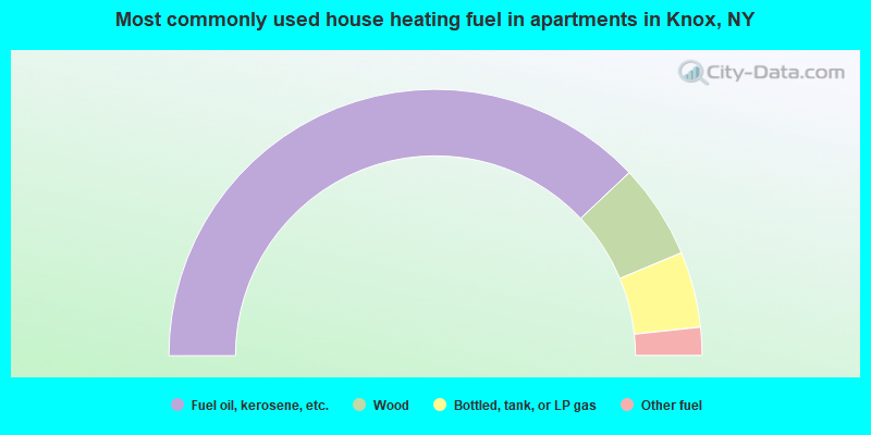
- 75.9%Fuel oil, kerosene, etc.
- 11.5%Wood
- 9.2%Bottled, tank, or LP gas
- 3.4%Other fuel
Knox compared to New York state average:
- Unemployed percentage significantly below state average.
- Black race population percentage significantly below state average.
- Hispanic race population percentage significantly below state average.
- Foreign-born population percentage significantly below state average.
- Renting percentage significantly below state average.
- Length of stay since moving in significantly above state average.
- Number of rooms per house significantly below state average.
- House age significantly below state average.
- Number of college students below state average.