Knight, Wisconsin
Submit your own pictures of this town and show them to the world
- OSM Map
- Google Map
- MSN Map
Population change since 2000: -25.7%
| Males: 102 | |
| Females: 109 |
| Median resident age: | 50.9 years |
| Wisconsin median age: | 42.6 years |
Zip codes: 54536.
| Knight: | $60,913 |
| WI: | $70,996 |
Estimated per capita income in 2022: $30,536 (it was $15,278 in 2000)
Knight town income, earnings, and wages data
Estimated median house or condo value in 2022: $99,646 (it was $40,700 in 2000)
| Knight: | $99,646 |
| WI: | $252,800 |
Mean prices in 2022: all housing units: $231,545; detached houses: $237,798; townhouses or other attached units: $114,627; in 2-unit structures: $45,407; in 3-to-4-unit structures: $106,715; in 5-or-more-unit structures: $145,737; mobile homes: $98,744
Detailed information about poverty and poor residents in Knight, WI


- 20798.1%White alone
- 20.9%Asian alone
- 10.5%American Indian alone
- 10.5%Two or more races

Races in Knight detailed stats: ancestries, foreign born residents, place of birth
 Recent articles from our blog. Our writers, many of them Ph.D. graduates or candidates, create easy-to-read articles on a wide variety of topics.
Ancestries: Italian (32.7%), German (12.7%), Swedish (7.7%), Irish (6.3%), English (6.0%), Polish (6.0%).
Current Local Time: CST time zone
Land area: 94.1 square miles.
Population density: 2.2 people per square mile (very low).
5 residents are foreign born
| This town: | 1.8% |
| Wisconsin: | 3.6% |
| Knight town: | 1.3% ($530) |
| Wisconsin: | 2.0% ($2,245) |
Nearest city with pop. 50,000+: Duluth, MN  (91.3 miles , pop. 86,918).
Nearest city with pop. 200,000+: St. Paul, MN (162.2 miles , pop. 287,151).
Nearest city with pop. 1,000,000+: Chicago, IL (334.0 miles , pop. 2,896,016).
Nearest cities:
), ), Latitude: 46.27 N, Longitude: 90.34 W
Area code commonly used in this area: 715

| Here: | 5.4% |
| Wisconsin: | 2.7% |

- Construction (12.6%)
- Wood products (10.9%)
- Health care (8.4%)
- Accommodation & food services (7.6%)
- Agriculture, forestry, fishing & hunting (6.7%)
- Groceries & related products merchant wholesalers (5.9%)
- Public administration (5.0%)

- Construction (18.8%)
- Groceries & related products merchant wholesalers (10.1%)
- Wood products (10.1%)
- Agriculture, forestry, fishing & hunting (8.7%)
- Professional, scientific, technical services (8.7%)
- Metal & metal products (4.3%)
- Public administration (4.3%)

- Health care (14.0%)
- Accommodation & food services (14.0%)
- Wood products (12.0%)
- Air transportation (6.0%)
- Public administration (6.0%)
- Other transportation, support activities, couriers (6.0%)
- Social assistance (6.0%)

- Other production occupations, including supervisors (10.1%)
- Sales representatives, services, wholesale and manufacturing (8.4%)
- Cooks and food preparation workers (6.7%)
- Counselors, social workers, and other community and social service specialists (4.2%)
- Other management occupations, except farmers and farm managers (4.2%)
- Carpenters (4.2%)
- Building and grounds cleaning and maintenance occupations (3.4%)

- Sales representatives, services, wholesale and manufacturing (11.6%)
- Carpenters (7.2%)
- Drafters, engineering, and mapping technicians (5.8%)
- Fishing, hunting, and forestry occupations (5.8%)
- Other material moving workers, except laborers (5.8%)
- Other construction workers and helpers (5.8%)
- Other production occupations, including supervisors (5.8%)

- Cooks and food preparation workers (16.0%)
- Other production occupations, including supervisors (16.0%)
- Other management occupations, except farmers and farm managers (10.0%)
- Bookkeeping, accounting, and auditing clerks (8.0%)
- Customer service representatives (6.0%)
- Laborers and material movers, hand (6.0%)
- Counselors, social workers, and other community and social service specialists (4.0%)
Average climate in Knight, Wisconsin
Based on data reported by over 4,000 weather stations


Tornado activity:
Knight-area historical tornado activity is significantly below Wisconsin state average. It is 69% smaller than the overall U.S. average.
On 6/8/1985, a category F3 (max. wind speeds 158-206 mph) tornado 24.6 miles away from the Knight town center killed 2 people and injured 42 people and caused between $5,000,000 and $50,000,000 in damages.
On 5/10/1953, a category F4 (max. wind speeds 207-260 mph) tornado 53.7 miles away from the town center killed 2 people and injured 24 people.
Earthquake activity:
Knight-area historical earthquake activity is significantly above Wisconsin state average. It is 75% smaller than the overall U.S. average.On 7/9/1975 at 14:54:15, a magnitude 4.6 (4.6 MB, Class: Light, Intensity: IV - V) earthquake occurred 277.0 miles away from Knight center
On 3/2/2017 at 16:53:31, a magnitude 3.2 (3.2 ML, Class: Light, Intensity: II - III) earthquake occurred 120.9 miles away from Knight center
On 2/7/2020 at 18:30:28, a magnitude 3.3 (3.3 ML) earthquake occurred 140.0 miles away from the city center
On 4/8/2020 at 17:14:33, a magnitude 3.3 (3.3 ML) earthquake occurred 140.8 miles away from the city center
On 1/9/2020 at 18:16:48, a magnitude 3.3 (3.3 MB) earthquake occurred 141.2 miles away from the city center
On 6/5/1993 at 01:24:53, a magnitude 4.1 (4.1 LG, Depth: 6.2 mi) earthquake occurred 288.9 miles away from Knight center
Magnitude types: regional Lg-wave magnitude (LG), body-wave magnitude (MB), local magnitude (ML)
Natural disasters:
The number of natural disasters in Iron County (11) is smaller than the US average (15).Major Disasters (Presidential) Declared: 8
Emergencies Declared: 2
Causes of natural disasters: Floods: 8, Storms: 5, Winds: 3, Tornadoes: 2, Drought: 1, Heavy Rain: 1, Hurricane: 1, Landslide: 1, Other: 1 (Note: some incidents may be assigned to more than one category).
Hospitals and medical centers near Knight:
- VILLA MARIA HEALTH AND REHAB CTR (Nursing Home, about 15 miles away; HURLEY, WI)
- SKY VIEW NURSING CENTER (Nursing Home, about 15 miles away; HURLEY, WI)
- MELLEN MANOR (Nursing Home, about 16 miles away; MELLEN, WI)
- JOSEPHSON NURSING HOME (Nursing Home, about 16 miles away; IRONWOOD, MI)
- WESTGATE NURSING AND REHAB COMMUNITY (Nursing Home, about 16 miles away; IRONWOOD, MI)
Colleges/universities with over 2000 students nearest to Knight:
- Wisconsin Indianhead Technical College (about 84 miles; Shell Lake, WI; Full-time enrollment: 2,414)
- University of Wisconsin-Superior (about 89 miles; Superior, WI; FT enrollment: 2,302)
- University of Minnesota-Duluth (about 91 miles; Duluth, MN; FT enrollment: 10,612)
- The College of Saint Scholastica (about 92 miles; Duluth, MN; FT enrollment: 3,762)
- Lake Superior College (about 93 miles; Duluth, MN; FT enrollment: 3,768)
- Northcentral Technical College (about 96 miles; Wausau, WI; FT enrollment: 3,356)
- Michigan Technological University (about 104 miles; Houghton, MI; FT enrollment: 6,078)
Points of interest:
Notable location: McIver Camp (A). Display/hide its location on the map
Cemetery: Hillside Cemetery (1). Display/hide its location on the map
Lakes: O'Brien Lake (A), Pleasant Lake (B), Sack Lake (C), Shine Lake (D), Twin Lake (E), Twin Lakes (F), Duck Lake (G), Fifteen Lake (H). Display/hide their locations on the map
Streams, rivers, and creeks: LeClair Creek (A), Turntable Creek (B), Pleasant Lake Outlet (C), Shine Creek (D). Display/hide their locations on the map
| This town: | 2.1 people |
| Wisconsin: | 2.4 people |
| This town: | 56.4% |
| Whole state: | 64.4% |
| This town: | 4.0% |
| Whole state: | 7.3% |
No gay or lesbian households reported
| This town: | 7.3% |
| Whole state: | 8.7% |
| This town: | 2.3% |
| Whole state: | 3.7% |
For population 15 years and over in Knight:

- Never married: 22.9%
- Now married: 54.5%
- Separated: 1.3%
- Widowed: 7.4%
- Divorced: 13.9%
For population 25 years and over in Knight:
- High school or higher: 85.4%
- Bachelor's degree or higher: 13.6%
- Graduate or professional degree: 2.0%
- Unemployed: 11.2%
- Mean travel time to work (commute): 24.7 minutes


| Here: | 11.4 |
| Wisconsin average: | 11.0 |
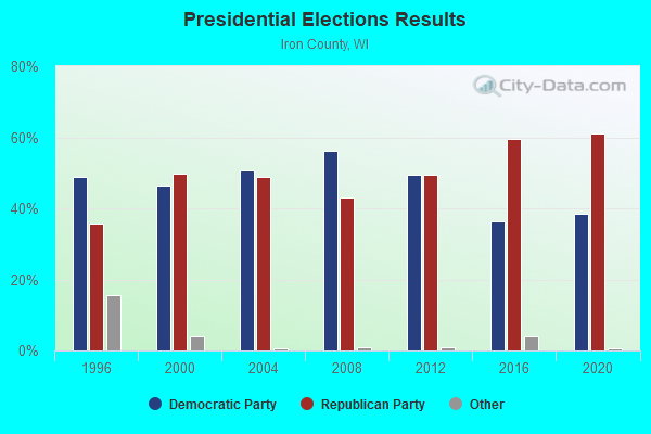
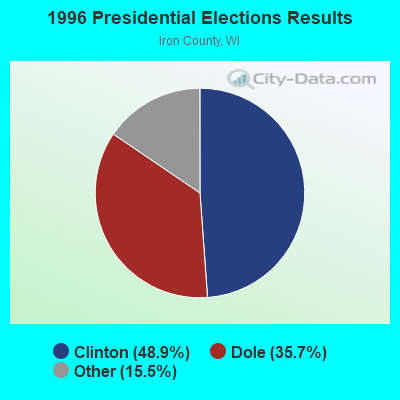
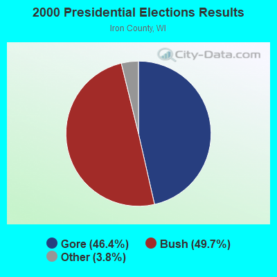
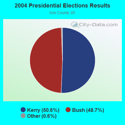
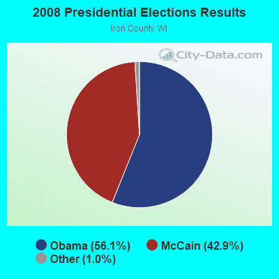
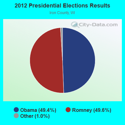
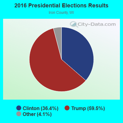
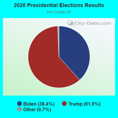
Graphs represent county-level data. Detailed 2008 Election Results
Religion statistics for Knight, WI (based on Iron County data)
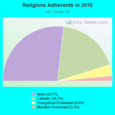
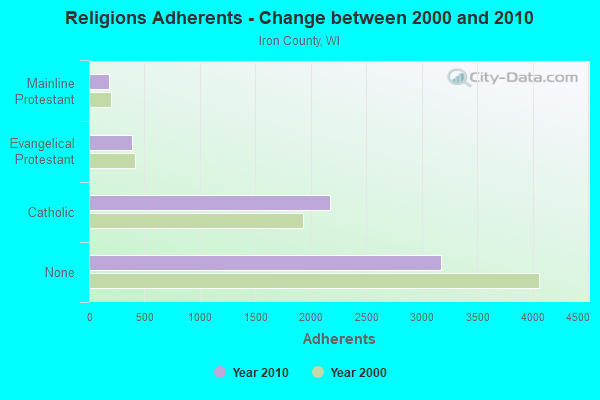
| Religion | Adherents | Congregations |
|---|---|---|
| Catholic | 2,173 | 3 |
| Evangelical Protestant | 388 | 6 |
| Mainline Protestant | 181 | 3 |
| None | 3,174 | - |
Food Environment Statistics:
| Iron County: | 3.18 / 10,000 pop. |
| Wisconsin: | 1.86 / 10,000 pop. |
| Iron County: | 11.13 / 10,000 pop. |
| Wisconsin: | 4.12 / 10,000 pop. |
| Here: | 23.85 / 10,000 pop. |
| Wisconsin: | 8.64 / 10,000 pop. |
| This county: | 8.9% |
| State: | 7.6% |
| This county: | 26.7% |
| Wisconsin: | 27.5% |
| Iron County: | 13.1% |
| Wisconsin: | 13.0% |
Strongest AM radio stations in Knight:
- WJMS (590 AM; 5 kW; IRONWOOD, MI; Owner: ROBERTS BROADCASTING, INC.)
- WEBC (560 AM; 50 kW; DULUTH, MN)
- WHRY (1450 AM; 1 kW; HURLEY, WI; Owner: BIG G LITTLE O INC.)
- WSPT (1010 AM; 50 kW; STEVENS POINT, WI)
- WSAU (550 AM; 20 kW; WAUSAU, WI; Owner: WRIG, INC.)
- WCCO (830 AM; 50 kW; MINNEAPOLIS, MN; Owner: INFINITY MEDIA CORPORATION)
- WCTS (1030 AM; 50 kW; MAPLEWOOD, MN; Owner: CNTL. BAPT. THEO/AL SEMI MINNEAPOLIS)
- WLKD (1570 AM; 5 kW; MINOCQUA, WI; Owner: RAVEN BROADCASTING CORPORATION)
- WDSM (710 AM; 10 kW; SUPERIOR, WI; Owner: MIDWEST COMMUNICATIONS, INC.)
- WNBI (980 AM; 1 kW; PARK FALLS, WI)
- WHSM (910 AM; 5 kW; HAYWARD, WI; Owner: QB BROADCASTING, LTD.)
- KSTP (1500 AM; 50 kW; ST. PAUL, MN; Owner: KSTP-AM, LLC (DELAWARE))
- WWJC (850 AM; daytime; 10 kW; DULUTH, MN; Owner: WWJC, INC.)
Strongest FM radio stations in Knight:
- WIMI (99.7 FM; IRONWOOD, MI; Owner: ROBERTS BROADCASTING, INC.)
- WHBM-FM (90.3 FM; PARK FALLS, WI; Owner: STATE OF WISCONSIN - EDUCATIONAL COMMUNICATIONS BOARD)
- W280DD (103.9 FM; IRONWOOD, MI; Owner: GOSPEL OPPORTUNITIES, INC.)
- WUPM (106.9 FM; IRONWOOD, MI; Owner: BIG G LITTLE O, INC.)
- W207BR (89.3 FM; IRONWOOD, MI; Owner: NORTHWESTERN COLLEGE)
- W265AI (100.9 FM; IRONWOOD, MI; Owner: WHITE PINE COMMUNITY B/C, INC.)
- WCQM (98.3 FM; PARK FALLS, WI; Owner: MIDWEST RADIO NETWORK, LLC)
TV broadcast stations around Knight:
- WLEF-TV (Channel 36; PARK FALLS, WI; Owner: STATE OF WISCONSIN - EDUCATIONAL COMMUNICATIONS BOARD)
- WYOW (Channel 34; EAGLE RIVER, WI; Owner: WAOW-WYOW TELEVISION, INC.)
- National Bridge Inventory (NBI) Statistics
- 1Number of bridges
- 3ft / 1.1mTotal length
- 214Total average daily traffic
- 10Total average daily truck traffic
- 235Total future (year 2039) average daily traffic

- 58.3%Fuel oil, kerosene, etc.
- 21.9%Bottled, tank, or LP gas
- 15.6%Wood
- 2.1%Utility gas
- 2.1%Electricity

- 62.5%Electricity
- 25.0%Fuel oil, kerosene, etc.
- 12.5%Wood
Knight compared to Wisconsin state average:
- Median house value significantly below state average.
- Black race population percentage significantly below state average.
- Hispanic race population percentage significantly below state average.
- Median age significantly above state average.
- Foreign-born population percentage significantly below state average.
- Renting percentage significantly below state average.
- Length of stay since moving in significantly above state average.
- Number of rooms per house significantly below state average.
- House age significantly below state average.
- Percentage of population with a bachelor's degree or higher below state average.