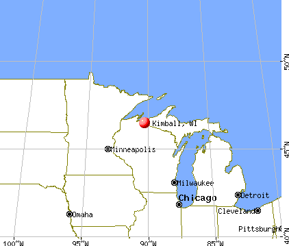
Kimball, Wisconsin
Submit your own pictures of this town and show them to the world
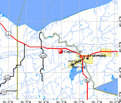
- OSM Map
- General Map
- Google Map
- MSN Map
Population change since 2000: -7.8%
 |
| Males: 250 | |
| Females: 248 |
| Median resident age: | 47.4 years |
| Wisconsin median age: | 42.6 years |
Zip codes: 54534.
| Kimball: | $62,356 |
| WI: | $70,996 |
Estimated per capita income in 2022: $38,175 (it was $19,100 in 2000)
Kimball town income, earnings, and wages data
Estimated median house or condo value in 2022: $162,323 (it was $66,300 in 2000)
| Kimball: | $162,323 |
| WI: | $252,800 |
Mean prices in 2022: all housing units: $231,545; detached houses: $237,798; townhouses or other attached units: $114,627; in 2-unit structures: $45,407; in 3-to-4-unit structures: $106,715; in 5-or-more-unit structures: $145,737; mobile homes: $98,744
Detailed information about poverty and poor residents in Kimball, WI
Compare current foreclosures near Kimball, WI:
| Photo | Address | Area | Beds / Baths | Price | Details |
|---|---|---|---|---|---|

|
#1
Sunset Rd
Ironwood, MI 49938
|
- sq. feet
|
1 baths 3 beds |
show details | |

|
#2
Granite St
Hurley, WI 54534
|
- sq. feet
|
- baths - beds |
show details | |

|
#3
1/2 Riverside Dr
Hurley, WI 54534
|
- sq. feet
|
- baths - beds |
show details | |

|
#4
E Coolidge Ave
Ironwood, MI 49938
|
- sq. feet
|
- baths - beds |
show details | |

|
#5
E Oak St
Ironwood, MI 49938
|
- sq. feet
|
- baths - beds |
show details | |

|
#6
E Silver St
Bessemer, MI 49911
|
- sq. feet
|
- baths - beds |
show details | |

|
#7
E Midland Ave
Ironwood, MI 49938
|
- sq. feet
|
- baths - beds |
show details | |

|
Check over 1 million property listings on Foreclosure.com!
|
browse all offers | |||

- 48497.2%White alone
- 71.4%Two or more races
- 61.2%American Indian alone
- 10.2%Asian alone

Races in Kimball detailed stats: ancestries, foreign born residents, place of birth
 Recent articles from our blog. Our writers, many of them Ph.D. graduates or candidates, create easy-to-read articles on a wide variety of topics.

Latest news from Kimball, WI collected exclusively by city-data.com from local newspapers, TV, and radio stations
Ancestries: German (18.9%), Italian (18.3%), Polish (11.1%), French (6.9%), English (6.3%), Swedish (6.3%).
Current Local Time: CST time zone
Elevation: 1260 feet
Land area: 37.1 square miles.
Population density: 13 people per square mile (very low).
24 residents are foreign born (3.7% Europe, 0.7% North America).
| This town: | 4.4% |
| Wisconsin: | 3.6% |
| Kimball town: | 1.5% ($1,012) |
| Wisconsin: | 2.0% ($2,245) |
Nearest city with pop. 50,000+: Duluth, MN  (90.6 miles , pop. 86,918).
Nearest city with pop. 200,000+: St. Paul, MN (173.6 miles , pop. 287,151).
Nearest city with pop. 1,000,000+: Chicago, IL (345.5 miles , pop. 2,896,016).
Nearest cities:
), Latitude: 46.48 N, Longitude: 90.26 W


| Here: | 5.4% |
| Wisconsin: | 2.7% |

- Accommodation & food services (12.4%)
- Educational services (10.4%)
- Health care (9.2%)
- Construction (7.6%)
- Public administration (7.2%)
- Food & beverage stores (4.0%)
- Agriculture, forestry, fishing & hunting (3.6%)

- Construction (13.5%)
- Educational services (10.6%)
- Accommodation & food services (7.8%)
- Motor vehicle & parts dealers (6.4%)
- Public administration (5.7%)
- Agriculture, forestry, fishing & hunting (5.0%)
- Food & beverage stores (5.0%)

- Accommodation & food services (18.5%)
- Health care (17.6%)
- Educational services (10.2%)
- Public administration (9.3%)
- Used merchandise, gift, novelty, souvenir, other miscellaneous stores (4.6%)
- Social assistance (4.6%)
- Personal & laundry services (3.7%)

- Other sales and related occupations, including supervisors (6.8%)
- Supervisors and other personal care and service workers, except child care workers (5.2%)
- Other management occupations, except farmers and farm managers (5.2%)
- Building and grounds cleaning and maintenance occupations (4.8%)
- Cooks and food preparation workers (4.0%)
- Preschool, kindergarten, elementary, and middle school teachers (3.6%)
- Secretaries and administrative assistants (3.6%)

- Other sales and related occupations, including supervisors (10.6%)
- Other management occupations, except farmers and farm managers (6.4%)
- Cooks and food preparation workers (5.0%)
- Vehicle and mobile equipment mechanics, installers, and repairers (5.0%)
- Carpenters (5.0%)
- Supervisors and other personal care and service workers, except child care workers (5.0%)
- Building and grounds cleaning and maintenance occupations (4.3%)

- Secretaries and administrative assistants (8.3%)
- Waiters and waitresses (6.5%)
- Registered nurses (6.5%)
- Counselors, social workers, and other community and social service specialists (5.6%)
- Building and grounds cleaning and maintenance occupations (5.6%)
- Supervisors and other personal care and service workers, except child care workers (5.6%)
- Health technologists and technicians (4.6%)
Average climate in Kimball, Wisconsin
Based on data reported by over 4,000 weather stations


(lower is better)

Air Quality Index (AQI) level in 2022 was 52.3. This is better than average.
| City: | 52.3 |
| U.S.: | 72.6 |

Ozone [ppb] level in 2022 was 29.9. This is about average. Closest monitor was 20.6 miles away from the city center.
| City: | 29.9 |
| U.S.: | 33.3 |

Particulate Matter (PM2.5) [µg/m3] level in 2022 was 4.98. This is significantly better than average. Closest monitor was 20.6 miles away from the city center.
| City: | 4.98 |
| U.S.: | 8.11 |
Tornado activity:
Kimball-area historical tornado activity is significantly below Wisconsin state average. It is 78% smaller than the overall U.S. average.
On 6/8/1985, a category F3 (max. wind speeds 158-206 mph) tornado 39.4 miles away from the Kimball town center killed 2 people and injured 42 people and caused between $5,000,000 and $50,000,000 in damages.
On 4/27/1984, a category F3 tornado 46.2 miles away from the town center killed one person and injured 8 people and caused between $5,000,000 and $50,000,000 in damages.
Earthquake activity:
Kimball-area historical earthquake activity is significantly above Wisconsin state average. It is 75% smaller than the overall U.S. average.On 7/9/1975 at 14:54:15, a magnitude 4.6 (4.6 MB, Class: Light, Intensity: IV - V) earthquake occurred 282.9 miles away from the city center
On 3/2/2017 at 16:53:31, a magnitude 3.2 (3.2 ML, Class: Light, Intensity: II - III) earthquake occurred 112.8 miles away from Kimball center
On 2/7/2020 at 18:30:28, a magnitude 3.3 (3.3 ML) earthquake occurred 135.2 miles away from the city center
On 4/8/2020 at 17:14:33, a magnitude 3.3 (3.3 ML) earthquake occurred 135.2 miles away from the city center
On 1/9/2020 at 18:16:48, a magnitude 3.3 (3.3 MB) earthquake occurred 135.9 miles away from Kimball center
On 4/24/2020 at 17:23:43, a magnitude 3.2 (3.2 ML) earthquake occurred 128.9 miles away from Kimball center
Magnitude types: body-wave magnitude (MB), local magnitude (ML)
Natural disasters:
The number of natural disasters in Iron County (11) is smaller than the US average (15).Major Disasters (Presidential) Declared: 8
Emergencies Declared: 2
Causes of natural disasters: Floods: 8, Storms: 5, Winds: 3, Tornadoes: 2, Drought: 1, Heavy Rain: 1, Hurricane: 1, Landslide: 1, Other: 1 (Note: some incidents may be assigned to more than one category).

Hospitals and medical centers near Kimball:
- WESTGATE NURSING AND REHAB COMMUNITY (Nursing Home, about 5 miles away; IRONWOOD, MI)
- SKY VIEW NURSING CENTER (Nursing Home, about 5 miles away; HURLEY, WI)
- VILLA MARIA HEALTH AND REHAB CTR (Nursing Home, about 5 miles away; HURLEY, WI)
- JOSEPHSON NURSING HOME (Nursing Home, about 6 miles away; IRONWOOD, MI)
- GOGEBIC MEDICAL CARE FACILITY (Nursing Home, about 15 miles away; WAKEFIELD, MI)
Colleges/universities with over 2000 students nearest to Kimball:
- University of Wisconsin-Superior (about 89 miles; Superior, WI; Full-time enrollment: 2,302)
- University of Minnesota-Duluth (about 90 miles; Duluth, MN; FT enrollment: 10,612)
- The College of Saint Scholastica (about 91 miles; Duluth, MN; FT enrollment: 3,762)
- Lake Superior College (about 92 miles; Duluth, MN; FT enrollment: 3,768)
- Michigan Technological University (about 93 miles; Houghton, MI; FT enrollment: 6,078)
- Wisconsin Indianhead Technical College (about 95 miles; Shell Lake, WI; FT enrollment: 2,414)
- Northcentral Technical College (about 108 miles; Wausau, WI; FT enrollment: 3,356)
Points of interest:
Notable locations in Kimball: Kimball Town Hall (A), Kimball Fire Department (B). Display/hide their locations on the map
Reservoirs: 0.09 Reservoir (A), La Blonde Flowage 1 (B). Display/hide their locations on the map
Rivers and creeks: Kaari Creek (A), West Fork Montreal River (B), Flood Creek (C), Boomer Creek (D), Kurikka Creek (E), Cominski Creek (F). Display/hide their locations on the map
| This town: | 2.4 people |
| Wisconsin: | 2.4 people |
| This town: | 68.6% |
| Whole state: | 64.4% |
| This town: | 7.6% |
| Whole state: | 7.3% |
No gay or lesbian households reported
| This town: | 8.1% |
| Whole state: | 8.7% |
| This town: | 1.1% |
| Whole state: | 3.7% |
For population 15 years and over in Kimball:

- Never married: 24.3%
- Now married: 59.5%
- Separated: 1.8%
- Widowed: 9.8%
- Divorced: 4.7%
For population 25 years and over in Kimball:
- High school or higher: 81.4%
- Bachelor's degree or higher: 16.7%
- Graduate or professional degree: 3.8%
- Unemployed: 11.1%
- Mean travel time to work (commute): 16.4 minutes


| Here: | 9.0 |
| Wisconsin average: | 11.0 |
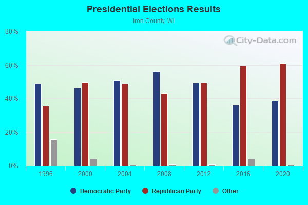
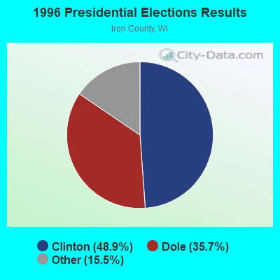
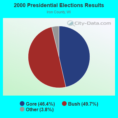
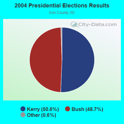
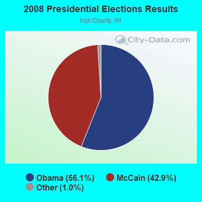
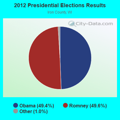
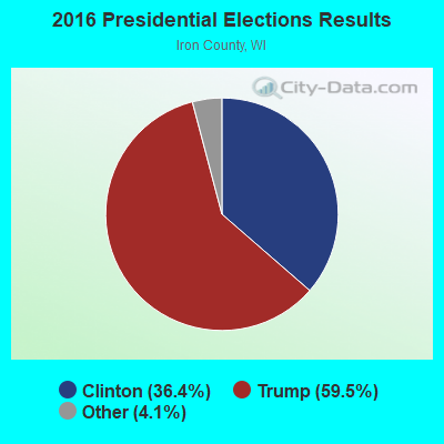
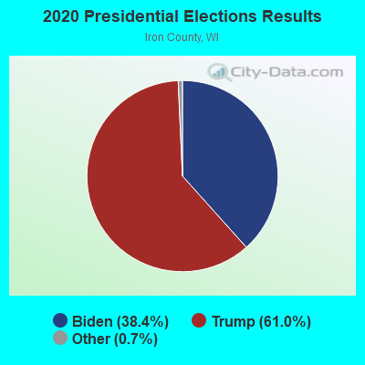
Graphs represent county-level data. Detailed 2008 Election Results
Religion statistics for Kimball, WI (based on Iron County data)
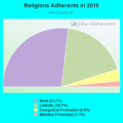
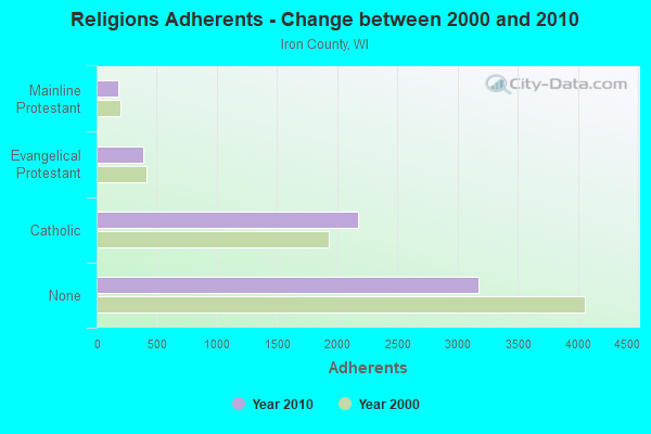
| Religion | Adherents | Congregations |
|---|---|---|
| Catholic | 2,173 | 3 |
| Evangelical Protestant | 388 | 6 |
| Mainline Protestant | 181 | 3 |
| None | 3,174 | - |
Food Environment Statistics:
| Iron County: | 3.18 / 10,000 pop. |
| Wisconsin: | 1.86 / 10,000 pop. |
| Iron County: | 11.13 / 10,000 pop. |
| Wisconsin: | 4.12 / 10,000 pop. |
| Iron County: | 23.85 / 10,000 pop. |
| Wisconsin: | 8.64 / 10,000 pop. |
| Here: | 8.9% |
| Wisconsin: | 7.6% |
| This county: | 26.7% |
| State: | 27.5% |
| Here: | 13.1% |
| Wisconsin: | 13.0% |
Strongest AM radio stations in Kimball:
- WJMS (590 AM; 5 kW; IRONWOOD, MI; Owner: ROBERTS BROADCASTING, INC.)
- WHRY (1450 AM; 1 kW; HURLEY, WI; Owner: BIG G LITTLE O INC.)
- WEBC (560 AM; 50 kW; DULUTH, MN)
- WSPT (1010 AM; 50 kW; STEVENS POINT, WI)
- WSAU (550 AM; 20 kW; WAUSAU, WI; Owner: WRIG, INC.)
- WCCO (830 AM; 50 kW; MINNEAPOLIS, MN; Owner: INFINITY MEDIA CORPORATION)
- WCTS (1030 AM; 50 kW; MAPLEWOOD, MN; Owner: CNTL. BAPT. THEO/AL SEMI MINNEAPOLIS)
- WDSM (710 AM; 10 kW; SUPERIOR, WI; Owner: MIDWEST COMMUNICATIONS, INC.)
- WWJC (850 AM; daytime; 10 kW; DULUTH, MN; Owner: WWJC, INC.)
- KSTP (1500 AM; 50 kW; ST. PAUL, MN; Owner: KSTP-AM, LLC (DELAWARE))
- WLKD (1570 AM; 5 kW; MINOCQUA, WI; Owner: RAVEN BROADCASTING CORPORATION)
- WNAM (1280 AM; 50 kW; NEENAH-MENASHA, WI; Owner: CUMULUS LICENSING CORP.)
- KFAN (1130 AM; 50 kW; MINNEAPOLIS, MN; Owner: AMFM RADIO LICENSES, L.L.C.)
Strongest FM radio stations in Kimball:
- WIMI (99.7 FM; IRONWOOD, MI; Owner: ROBERTS BROADCASTING, INC.)
- W280DD (103.9 FM; IRONWOOD, MI; Owner: GOSPEL OPPORTUNITIES, INC.)
- W207BR (89.3 FM; IRONWOOD, MI; Owner: NORTHWESTERN COLLEGE)
- W265AI (100.9 FM; IRONWOOD, MI; Owner: WHITE PINE COMMUNITY B/C, INC.)
- WUPM (106.9 FM; IRONWOOD, MI; Owner: BIG G LITTLE O, INC.)
- WHBM-FM (90.3 FM; PARK FALLS, WI; Owner: STATE OF WISCONSIN - EDUCATIONAL COMMUNICATIONS BOARD)
- W224AW (92.7 FM; BERGLAND, MI; Owner: GOSPEL OPPORTUNITIES, INC.)
- WEGZ (105.9 FM; WASHBURN, WI; Owner: KEWEENAW BAY BROADCASTING, INC.)
- W201BP (88.1 FM; IRONWOOD, MI; Owner: VCY AMERICA, INC.)
TV broadcast stations around Kimball:
- WLEF-TV (Channel 36; PARK FALLS, WI; Owner: STATE OF WISCONSIN - EDUCATIONAL COMMUNICATIONS BOARD)
- WYOW (Channel 34; EAGLE RIVER, WI; Owner: WAOW-WYOW TELEVISION, INC.)
- National Bridge Inventory (NBI) Statistics
- 9Number of bridges
- 59ft / 18.0mTotal length
- $379,000Total costs
- 5,548Total average daily traffic
- 656Total average daily truck traffic
FCC Registered Amateur Radio Licenses:
1- Call Sign: NC9K, Licensee ID: L00602857, Grant Date: 02/26/2020, Expiration Date: 03/20/2030, Registrant: Leland J Sarmont, 6371w Center Drive, Kimball, WI 54534

- 32.7%Fuel oil, kerosene, etc.
- 30.3%Bottled, tank, or LP gas
- 27.4%Wood
- 5.3%Utility gas
- 3.4%Electricity
- 1.0%Other fuel

- 50.0%Electricity
- 28.6%Bottled, tank, or LP gas
- 21.4%Utility gas
Kimball compared to Wisconsin state average:
- Median house value below state average.
- Black race population percentage significantly below state average.
- Hispanic race population percentage significantly below state average.
- Median age above state average.
- Renting percentage significantly below state average.
- Length of stay since moving in significantly above state average.
- Number of rooms per house significantly below state average.
- House age significantly below state average.
- Number of college students below state average.