Johnstown precinct, Nebraska
Submit your own pictures of this city and show them to the world
- OSM Map
- General Map
- Google Map
- MSN Map

| Males: 170 | |
| Females: 141 |
| Median resident age: | 38.2 years |
| Nebraska median age: | 35.3 years |
Zip code: 69210
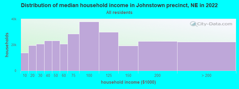
| Johnstown precinct: | $41,848 |
| NE: | $69,597 |
Estimated per capita income in 2022: $33,688 (it was $16,706 in 2000)
Johnstown precinct income, earnings, and wages data
Estimated median house or condo value in 2022: $138,456 (it was $65,000 in 2000)
| Johnstown precinct: | $138,456 |
| NE: | $232,400 |
Mean prices in 2022: all housing units: $125,699; detached houses: $127,655; mobile homes: $63,701
Johnstown precinct, NE residents, houses, and apartments details
Detailed information about poverty and poor residents in Johnstown precinct, NE
Compare current foreclosures near Johnstown precinct, NE:
| Photo | Address | Area | Beds / Baths | Price | Details |
|---|---|---|---|---|---|

|
#1
W 2nd St
Ainsworth, NE 69210
|
1,190 sq. feet
|
1 baths 3 beds |
show details | |

|
#2
N Walnut St
Ainsworth, NE 69210
|
1,334 sq. feet
|
2 baths 5 beds |
show details | |

|
Check over 1 million property listings on Foreclosure.com!
|
browse all offers | |||

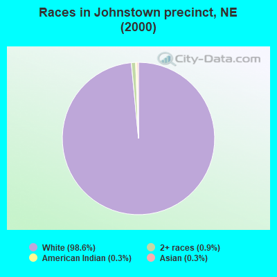
- 34098.6%White alone
- 30.9%Two or more races
- 10.3%American Indian alone
- 10.3%Asian alone
Races in Johnstown precinct detailed stats: ancestries, foreign born residents, place of birth
 Recent articles from our blog. Our writers, many of them Ph.D. graduates or candidates, create easy-to-read articles on a wide variety of topics.
Current Local Time: CST time zone
Land area: 535.9 square miles.
Population density: 0.6 people per square mile (very low).

| Johnstown precinct: | 0.4% ($275) |
| Nebraska: | 1.7% ($1,478) |
Nearest city with pop. 50,000+: Sioux Falls, SD  (181.4 miles , pop. 123,975).
Nearest city with pop. 200,000+: Lincoln, NE (211.8 miles , pop. 225,581).
Nearest city with pop. 1,000,000+: Chicago, IL (635.4 miles , pop. 2,896,016).
Nearest cities:
), Latitude: 42.54 N, Longitude: 100.05 W
Area code commonly used in this area: 402

| Here: | 2.4% |
| Nebraska: | 2.2% |
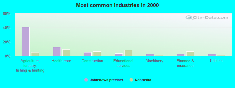
- Agriculture, forestry, fishing & hunting (40.9%)
- Health care (12.7%)
- Construction (5.5%)
- Educational services (3.9%)
- Machinery (2.8%)
- Finance & insurance (2.8%)
- Utilities (2.8%)
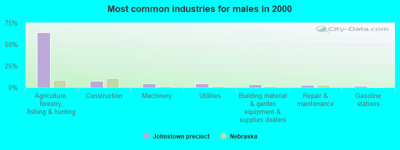
- Agriculture, forestry, fishing & hunting (64.2%)
- Construction (7.5%)
- Machinery (4.7%)
- Utilities (4.7%)
- Building material & garden equipment & supplies dealers (3.8%)
- Repair & maintenance (2.8%)
- Gasoline stations (1.9%)
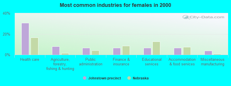
- Health care (30.7%)
- Agriculture, forestry, fishing & hunting (8.0%)
- Public administration (6.7%)
- Finance & insurance (6.7%)
- Educational services (6.7%)
- Accommodation & food services (6.7%)
- Miscellaneous manufacturing (4.0%)
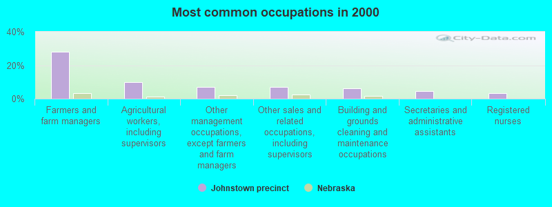
- Farmers and farm managers (28.2%)
- Agricultural workers, including supervisors (9.9%)
- Other management occupations, except farmers and farm managers (7.2%)
- Other sales and related occupations, including supervisors (7.2%)
- Building and grounds cleaning and maintenance occupations (6.1%)
- Secretaries and administrative assistants (4.4%)
- Registered nurses (3.3%)
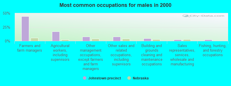
- Farmers and farm managers (44.3%)
- Agricultural workers, including supervisors (17.0%)
- Other management occupations, except farmers and farm managers (7.5%)
- Other sales and related occupations, including supervisors (7.5%)
- Building and grounds cleaning and maintenance occupations (4.7%)
- Sales representatives, services, wholesale and manufacturing (2.8%)
- Fishing, hunting, and forestry occupations (2.8%)
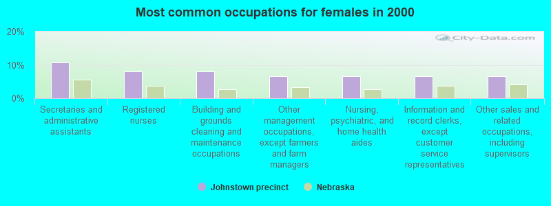
- Secretaries and administrative assistants (10.7%)
- Registered nurses (8.0%)
- Building and grounds cleaning and maintenance occupations (8.0%)
- Other management occupations, except farmers and farm managers (6.7%)
- Nursing, psychiatric, and home health aides (6.7%)
- Information and record clerks, except customer service representatives (6.7%)
- Other sales and related occupations, including supervisors (6.7%)
Average climate in Johnstown precinct, Nebraska
Based on data reported by over 4,000 weather stations


Tornado activity:
Johnstown precinct-area historical tornado activity is significantly below Nebraska state average. It is 30% smaller than the overall U.S. average.
On 5/8/1965, a category F5 (max. wind speeds 261-318 mph) tornado 35.8 miles away from the Johnstown precinct city center injured one person and caused between $500,000 and $5,000,000 in damages.
On 10/29/1956, a category F4 (max. wind speeds 207-260 mph) tornado 30.9 miles away from the city center injured 2 people and caused between $50,000 and $500,000 in damages.
Earthquake activity:
Johnstown precinct-area historical earthquake activity is significantly above Nebraska state average. It is 312% greater than the overall U.S. average.On 8/18/1959 at 06:37:13, a magnitude 7.7 (7.7 UK, Class: Major, Intensity: VIII - XII) earthquake occurred 549.0 miles away from Johnstown precinct center, causing $26,000,000 total damage
On 10/18/1984 at 15:30:23, a magnitude 5.5 (5.4 MB, 5.1 MS, 5.5 ML, Class: Moderate, Intensity: VI - VII) earthquake occurred 281.5 miles away from Johnstown precinct center
On 3/4/1983 at 06:32:18, a magnitude 4.6 (4.4 MB, 4.6 LG, 4.4 ML, Class: Light, Intensity: IV - V) earthquake occurred 120.0 miles away from Johnstown precinct center
On 11/3/2002 at 20:41:56, a magnitude 4.3 (4.3 MB, Depth: 3.1 mi) earthquake occurred 60.9 miles away from the city center
On 5/25/2003 at 07:32:33, a magnitude 4.0 (4.0 MB, Depth: 3.1 mi) earthquake occurred 95.9 miles away from Johnstown precinct center
On 9/8/1984 at 00:59:31, a magnitude 5.1 (5.1 MB) earthquake occurred 317.2 miles away from the city center
Magnitude types: regional Lg-wave magnitude (LG), body-wave magnitude (MB), local magnitude (ML), surface-wave magnitude (MS)
Natural disasters:
The number of natural disasters in Brown County (10) is smaller than the US average (15).Major Disasters (Presidential) Declared: 7
Emergencies Declared: 1
Causes of natural disasters: Floods: 5, Storms: 5, Tornadoes: 3, Winter Storms: 3, Hurricane: 1, Snowstorm: 1, Wind: 1, Other: 1 (Note: some incidents may be assigned to more than one category).
Hospitals and medical centers near Johnstown precinct:
Colleges/universities with over 2000 students nearest to Johnstown precinct:
- University of Nebraska at Kearney (about 137 miles; Kearney, NE; Full-time enrollment: 6,047)
- Northeast Community College (about 141 miles; Norfolk, NE; FT enrollment: 3,334)
- Central Community College (about 144 miles; Grand Island, NE; FT enrollment: 4,159)
- Chadron State College (about 152 miles; Chadron, NE; FT enrollment: 2,374)
- Wayne State College (about 157 miles; Wayne, NE; FT enrollment: 3,121)
- University of South Dakota (about 161 miles; Vermillion, SD; FT enrollment: 7,328)
- Southeast Technical Institute (about 181 miles; Sioux Falls, SD; FT enrollment: 2,386)
Points of interest:
Notable locations in Johnstown precinct: A Gudgel Ranch (A), Allen Ranch (B), Anderson Ranch (C), Arent Ranch (D), Baldwin Camp (E), Baxter Ranch (F), Bergen Ranch (G), Boyd Ranch (H), Burrows Ranch (I), C Keim Ranch (J), Cook Ranch (K), Darwin Ranch (L), Edwards Ranch (M), Enders Ranch (N), Galusha Ranch (O), Hershiser Ranch (P), Hurlbut Ranch (Q), Jameson Ranch (R), John Ranch (S), Johnny Kirkpatrick Ranch (T). Display/hide their locations on the map
Church in Johnstown precinct: United Methodist Church (A). Display/hide its location on the map
Cemeteries: East Woodlawn Cemetery (1), Grand Prairie Cemetery (2), Valley View Cemetery (3), Woodlawn Cemetery (4). Display/hide their locations on the map
Lakes and swamps: Philbrick Lake (A), Rat Lake (B), Alkali Lake (C), Skull Lake (D), Moon Lake (E), South Twin Lake (F), Willow Lake (G), Long Lake (H). Display/hide their locations on the map
Rivers and creeks: Muleshoe Creek (A), Garden Creek (B), Little Minnie Creek (C), Evergreen Creek (D), Bronson Creek (E), Fairfield Creek (F), Deep Creek (G), North Fork Plum Creek (H), Coon Creek (I). Display/hide their locations on the map
Parks in Johnstown precinct include: Long Lake Recreation Grounds (1), Berry Park (2), South Twin Lake State Wildlife Management Area (3), American Game Marsh State Wildlife Management Area (4), Ainsworth Army Air Field Historical Marker (5), Lakeland Sod High School Historical Marker (6), Long Lake State Wildlife Management Area (7). Display/hide their locations on the map
| This city: | 2.2 people |
| Nebraska: | 2.5 people |
| This city: | 71.8% |
| Whole state: | 64.8% |
| This city: | 4.6% |
| Whole state: | 6.0% |
No gay or lesbian households reported
| This city: | 10.3% |
| Whole state: | 9.7% |
| This city: | 4.4% |
| Whole state: | 4.0% |
For population 15 years and over in Johnstown precinct:
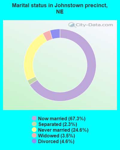
- Never married: 24.6%
- Now married: 67.3%
- Separated: 2.3%
- Widowed: 3.5%
- Divorced: 4.6%
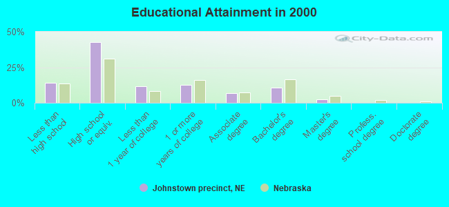
For population 25 years and over in Johnstown precinct:
- High school or higher: 85.8%
- Bachelor's degree or higher: 12.8%
- Graduate or professional degree: 2.2%
- Unemployed: 1.1%
- Mean travel time to work (commute): 15.9 minutes
| Here: | 8.7 |
| Nebraska average: | 11.1 |
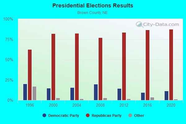
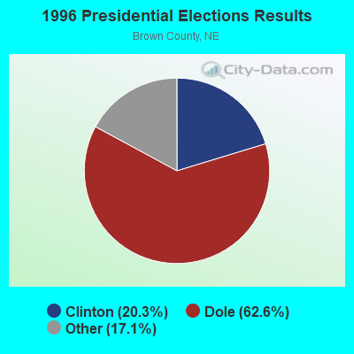
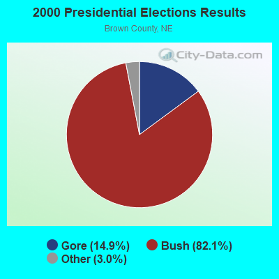
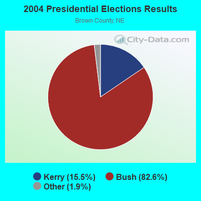
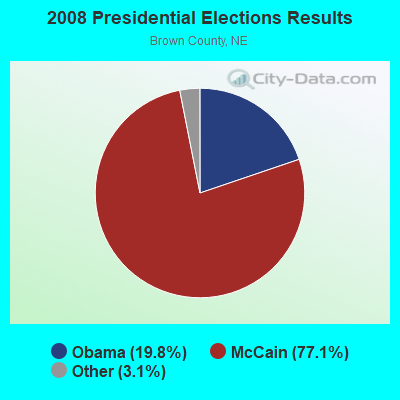
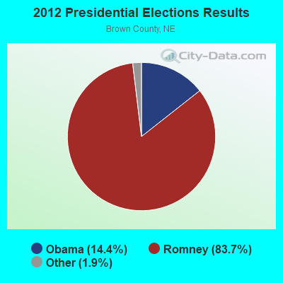
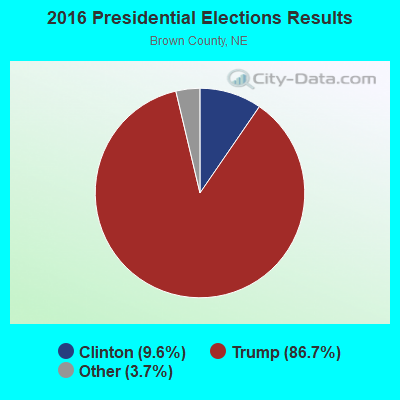
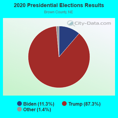
Graphs represent county-level data. Detailed 2008 Election Results
Religion statistics for Johnstown precinct, NE (based on Brown County data)
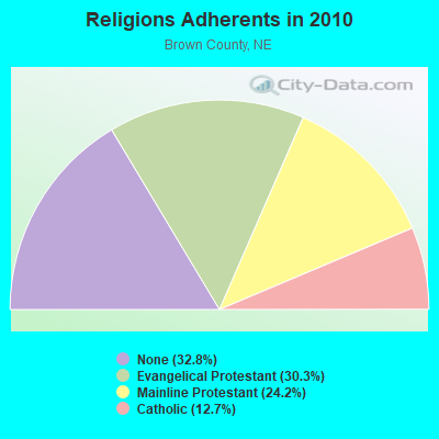
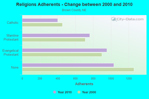
| Religion | Adherents | Congregations |
|---|---|---|
| Evangelical Protestant | 953 | 5 |
| Mainline Protestant | 760 | 4 |
| Catholic | 400 | 1 |
| Other | 1 | 1 |
| None | 1,031 | - |
Food Environment Statistics:
| Here: | 9.38 / 10,000 pop. |
| Nebraska: | 2.60 / 10,000 pop. |
| Brown County: | 12.50 / 10,000 pop. |
| Nebraska: | 4.83 / 10,000 pop. |
| Brown County: | 15.63 / 10,000 pop. |
| Nebraska: | 7.76 / 10,000 pop. |
| Brown County: | 9.6% |
| Nebraska: | 7.9% |
| Brown County: | 28.2% |
| Nebraska: | 28.0% |
| Brown County: | 7.4% |
| Nebraska: | 12.9% |
Strongest AM radio stations in Johnstown precinct:
- KBRB (1400 AM; 1 kW; AINSWORTH, NE; Owner: KBRB BROADCASTING CO.)
- KVSH (940 AM; 5 kW; VALENTINE, NE; Owner: HEART CITY RADIO COMPANY)
- KRVN (880 AM; 50 kW; LEXINGTON, NE; Owner: NEBRASKA RURAL RADIO ASSOCIATION)
- KWYR (1260 AM; 5 kW; WINNER, SD; Owner: MIDWEST RADIO CORP.)
- KIMB (1260 AM; 50 kW; KIMBALL, NE; Owner: G & L INVESTMENTS, LLC)
- KOIL (1020 AM; 50 kW; PLATTSMOUTH, NE; Owner: WAITT RADIO, INC.)
- KFAB (1110 AM; 50 kW; OMAHA, NE; Owner: CAPSTAR TX LIMITED PARTNERSHIP)
- KLTT (670 AM; 50 kW; COMMERCE CITY, CO; Owner: KLZ RADIO, INC.)
- KXMR (710 AM; 50 kW; BISMARCK, ND; Owner: RADIO BISMARCK MANDAN, LLC)
- KKAR (1290 AM; 50 kW; OMAHA, NE; Owner: WAITT RADIO, INC.)
- KKZN (760 AM; 50 kW; THORNTON, CO; Owner: JACOR BROADCASTING OF COLORADO, INC.)
- KBHB (810 AM; 25 kW; STURGIS, SD; Owner: MONTEREY LICENSES, LLC)
- KMMJ (750 AM; 10 kW; GRAND ISLAND, NE; Owner: JRK BROADCASTING, L.L.C.)
Strongest FM radio stations in Johnstown precinct:
- KBRB-FM (92.7 FM; AINSWORTH, NE; Owner: K.B.R. BROADCASTING CO.)
- KMNE-FM (90.3 FM; BASSETT, NE; Owner: NEBRASKA EDUCATIONAL TELECOMMUNICATIONS COMM.)
TV broadcast stations around Johnstown precinct:
- KMNE-TV (Channel 7; BASSETT, NE; Owner: NEBRASKA EDUCATIONAL TELECOMMUNICATIONS COMM.)
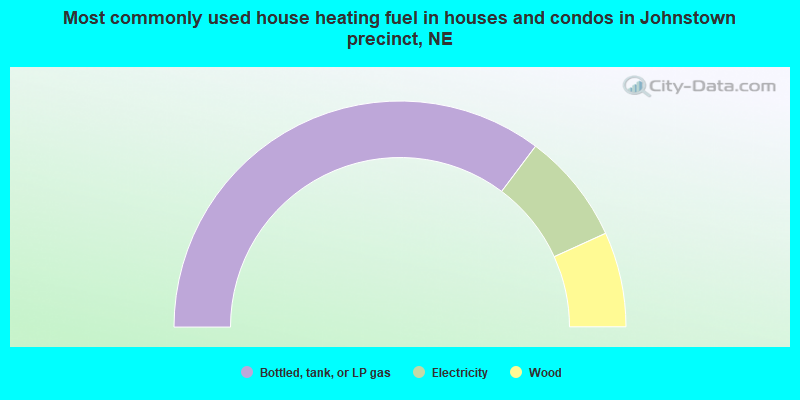
- 70.5%Bottled, tank, or LP gas
- 15.9%Electricity
- 13.6%Wood
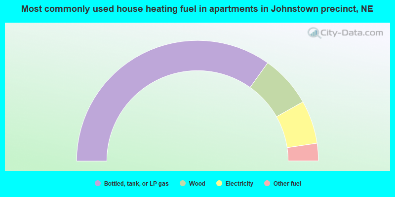
- 69.8%Bottled, tank, or LP gas
- 14.0%Wood
- 11.6%Electricity
- 4.7%Other fuel
Johnstown precinct compared to Nebraska state average:
- Median household income below state average.
- Median house value below state average.
- Unemployed percentage significantly below state average.
- Black race population percentage significantly below state average.
- Hispanic race population percentage significantly below state average.
- Foreign-born population percentage significantly below state average.
- Length of stay since moving in significantly above state average.
- Number of rooms per house significantly below state average.
- House age significantly below state average.
- Number of college students below state average.
- Percentage of population with a bachelor's degree or higher below state average.