Jearoldstown, Tennessee
Submit your own pictures of this place and show them to the world
- OSM Map
- General Map
- Google Map
- MSN Map

| Males: 1,461 | |
| Females: 1,485 |
| Median resident age: | 38.7 years |
| Tennessee median age: | 35.9 years |
Zip code: 37641
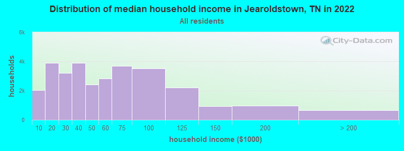
| Jearoldstown: | $50,882 |
| TN: | $65,254 |
Estimated per capita income in 2022: $27,301 (it was $16,448 in 2000)
Jearoldstown CCD income, earnings, and wages data
Estimated median house or condo value in 2022: $199,194 (it was $77,900 in 2000)
| Jearoldstown: | $199,194 |
| TN: | $284,800 |
Detailed information about poverty and poor residents in Jearoldstown, TN
Compare current foreclosures near Jearoldstown, TN:
| Photo | Address | Area | Beds / Baths | Price | Details |
|---|---|---|---|---|---|

|
#1
Scenic Dr
Greeneville, TN 37743
|
1,117 sq. feet
|
1 baths 3 beds |
show details | |

|
#2
Ted Brown Rd
Chuckey, TN 37641
|
1,577 sq. feet
|
1 baths 4 beds |
show details | |

|
#3
Princeton Rd
Kingsport, TN 37660
|
1,111 sq. feet
|
1 baths - beds |
show details | |

|
#4
Buckingham Dr
Johnson City, TN 37604
|
1,648 sq. feet
|
2 baths - beds |
show details | |

|
#5
Independence Ave
Mount Carmel, TN 37645
|
1,344 sq. feet
|
2 baths - beds |
show details | |

|
#6
Old Tusculum Rd
Greeneville, TN 37745
|
1,455 sq. feet
|
2 baths - beds |
show details | |

|
#7
Hardin Dr
Jonesborough, TN 37659
|
1,344 sq. feet
|
1 baths - beds |
show details | |

|
#8
Liberty Church Rd
Kingsport, TN 37663
|
1,042 sq. feet
|
2 baths - beds |
show details | |

|
#9
Gilda Ave
Church Hill, TN 37642
|
1,125 sq. feet
|
1 baths - beds |
show details | |

|
#10
Timbers E
Greeneville, TN 37745
|
1,484 sq. feet
|
2 baths - beds |
show details |
| Photo | Address | Area | Beds / Baths | Price | Details |
|---|---|---|---|---|---|

|
#11
Arnold Rd
Surgoinsville, TN 37873
|
864 sq. feet
|
1 baths - beds |
show details | |

|
#12
Rogan St
Kingsport, TN 37660
|
1,388 sq. feet
|
1 baths - beds |
show details | |

|
#13
Highway 81 S
Jonesborough, TN 37659
|
1,120 sq. feet
|
1 baths - beds |
show details | |

|
#14
Fry St
Greeneville, TN 37745
|
720 sq. feet
|
1 baths - beds |
show details | |

|
#15
Hopeville Ave
Greeneville, TN 37745
|
2,016 sq. feet
|
2 baths - beds |
show details | |

|
#16
Bohannon Ave
Greeneville, TN 37745
|
1,272 sq. feet
|
2 baths - beds |
show details | |

|
#17
Meadow Brook Ave
Jonesborough, TN 37659
|
1,330 sq. feet
|
2 baths - beds |
show details | |

|
#18
Suncrest St
Johnson City, TN 37615
|
1,270 sq. feet
|
1 baths - beds |
show details | |

|
#19
Long Hollow Rd
Rogersville, TN 37857
|
1,248 sq. feet
|
1 baths - beds |
show details | |

|
#20
Oak St
Johnson City, TN 37615
|
820 sq. feet
|
1 baths - beds |
show details |
| Photo | Address | Area | Beds / Baths | Price | Details |
|---|---|---|---|---|---|

|
#21
Catawba St
Church Hill, TN 37642
|
1,008 sq. feet
|
1 baths - beds |
show details | |

|
#22
Lewis Ln
Church Hill, TN 37642
|
1,208 sq. feet
|
1 baths - beds |
show details | |

|
#23
Okrina Dr
Church Hill, TN 37642
|
1,186 sq. feet
|
2 baths - beds |
show details | |

|
#24
E Bernard Ave
Greeneville, TN 37745
|
1,272 sq. feet
|
1 baths - beds |
show details | |

|
#25
E Sevier Ave
Kingsport, TN 37664
|
1,006 sq. feet
|
1 baths - beds |
show details | |

|
#26
Kendrick Creek Rd
Kingsport, TN 37663
|
1,269 sq. feet
|
1 baths - beds |
show details | |

|
#27
Myrtle St
Kingsport, TN 37660
|
1,530 sq. feet
|
1 baths - beds |
show details | |

|
#28
W Sullivan St
Kingsport, TN 37660
|
2,192 sq. feet
|
1 baths - beds |
show details | |

|
#29
Morrow Ln
Greeneville, TN 37745
|
1,992 sq. feet
|
1 baths - beds |
show details | |

|
#30
Riverside Ave
Kingsport, TN 37660
|
936 sq. feet
|
1 baths - beds |
show details |
| Photo | Address | Area | Beds / Baths | Price | Details |
|---|---|---|---|---|---|

|
#31
Doak Dr
Greeneville, TN 37745
|
1,689 sq. feet
|
2 baths - beds |
show details | |

|
#32
Ballard Rd
Johnson City, TN 37604
|
1,403 sq. feet
|
2 baths - beds |
show details | |

|
#33
Oak St
Church Hill, TN 37642
|
1,134 sq. feet
|
1 baths - beds |
show details | |

|
#34
Country Hills Ct
Jonesborough, TN 37659
|
1,764 sq. feet
|
2 baths - beds |
show details | |

|
#35
Faith Cir
Johnson City, TN 37604
|
936 sq. feet
|
1 baths - beds |
show details | |

|
#36
Poplar St
Mount Carmel, TN 37645
|
2,188 sq. feet
|
2 baths - beds |
show details | |

|
#37
Diana Rd
Kingsport, TN 37660
|
1,916 sq. feet
|
2 baths - beds |
show details | |

|
#38
Lauren Dr
Rogersville, TN 37857
|
1,366 sq. feet
|
2 baths - beds |
show details | |

|
#39
Garden Dr
Kingsport, TN 37664
|
1,400 sq. feet
|
2 baths - beds |
show details | |

|
#40
Oakland St
Kingsport, TN 37660
|
1,089 sq. feet
|
1 baths - beds |
show details |
| Photo | Address | Area | Beds / Baths | Price | Details |
|---|---|---|---|---|---|

|
#41
Old Mill Rd
Church Hill, TN 37642
|
1,949 sq. feet
|
2 baths - beds |
show details | |

|
#42
Old Union Rd
Church Hill, TN 37642
|
1,976 sq. feet
|
1 baths - beds |
show details | |

|
#43
1/2 Jerry Broyles Rd
Chuckey, TN 37641
|
1,360 sq. feet
|
1 baths - beds |
show details | |

|
#44
Willowbend Dr
Kingsport, TN 37660
|
1,312 sq. feet
|
2 baths - beds |
show details | |

|
#45
Woodvue Ave
Church Hill, TN 37642
|
1,664 sq. feet
|
2 baths - beds |
show details | |

|
#46
Cross Valley Rd
Surgoinsville, TN 37873
|
1,344 sq. feet
|
2 baths - beds |
show details | |

|
#47
Beechwood Dr
Kingsport, TN 37663
|
1,479 sq. feet
|
2 baths - beds |
show details | |

|
#48
Ridgecrest Rd
Jonesborough, TN 37659
|
1,008 sq. feet
|
1 baths - beds |
show details | |

|
#49
Mulberry Bnd
Jonesborough, TN 37659
|
2,348 sq. feet
|
3 baths - beds |
show details | |

|
Check over 1 million property listings on Foreclosure.com!
|
browse all offers | |||

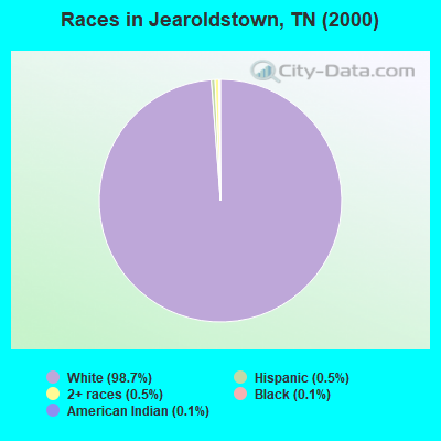
- 2,78398.7%White alone
- 140.5%Two or more races
- 150.5%Hispanic
- 40.1%Black alone
- 40.1%American Indian alone
Races in Jearoldstown detailed stats: ancestries, foreign born residents, place of birth
 Recent articles from our blog. Our writers, many of them Ph.D. graduates or candidates, create easy-to-read articles on a wide variety of topics.
Current Local Time: EST time zone
Elevation: 1390 feet
Land area: 49.9 square miles.
Population density: 59 people per square mile (very low).

| Jearoldstown CCD: | 0.5% ($421) |
| Tennessee: | 0.8% ($715) |
Nearest city with pop. 50,000+: Johnson City, TN  (18.3 miles , pop. 55,469).
Nearest city with pop. 200,000+: Charlotte, NC (131.2 miles , pop. 540,828).
Nearest city with pop. 1,000,000+: Chicago, IL (464.5 miles , pop. 2,896,016).
Nearest cities:
), ), ), ), ), Latitude: 36.34 N, Longitude: 82.70 W
Area code commonly used in this area: 423

| Here: | 3.9% |
| Tennessee: | 3.0% |
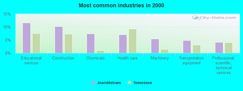
- Educational services (11.6%)
- Construction (10.2%)
- Chemicals (7.5%)
- Health care (7.1%)
- Machinery (5.4%)
- Transportation equipment (4.9%)
- Professional, scientific, technical services (4.2%)
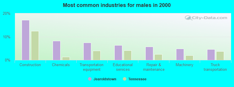
- Construction (17.2%)
- Chemicals (8.2%)
- Transportation equipment (7.5%)
- Educational services (6.3%)
- Repair & maintenance (5.7%)
- Machinery (4.8%)
- Truck transportation (4.6%)
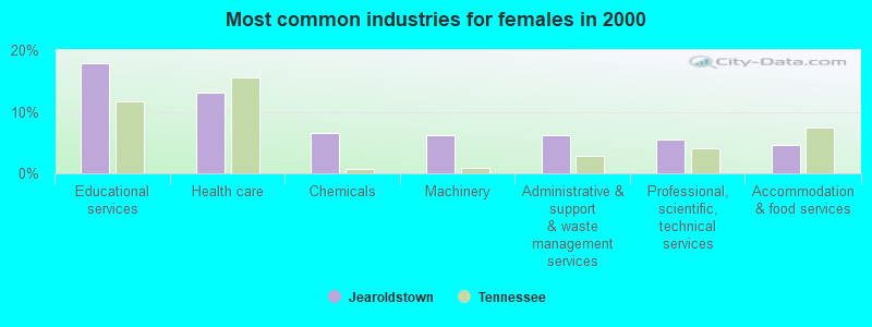
- Educational services (17.8%)
- Health care (13.1%)
- Chemicals (6.6%)
- Machinery (6.2%)
- Administrative & support & waste management services (6.2%)
- Professional, scientific, technical services (5.5%)
- Accommodation & food services (4.7%)
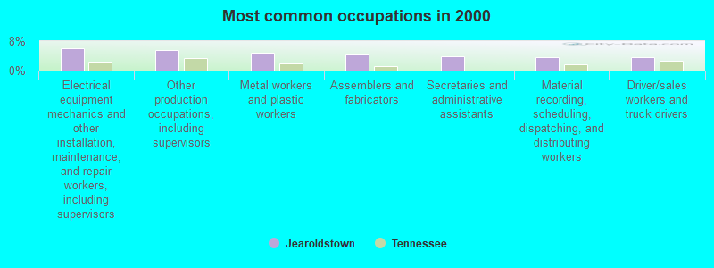
- Electrical equipment mechanics and other installation, maintenance, and repair workers, including supervisors (6.1%)
- Other production occupations, including supervisors (5.7%)
- Metal workers and plastic workers (5.0%)
- Assemblers and fabricators (4.4%)
- Secretaries and administrative assistants (3.8%)
- Material recording, scheduling, dispatching, and distributing workers (3.6%)
- Driver/sales workers and truck drivers (3.6%)
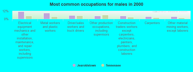
- Electrical equipment mechanics and other installation, maintenance, and repair workers, including supervisors (11.4%)
- Metal workers and plastic workers (9.3%)
- Driver/sales workers and truck drivers (5.5%)
- Other production occupations, including supervisors (4.8%)
- Construction traders workers except carpenters, electricians, painters, plumbers, and construction laborers (4.8%)
- Carpenters (3.7%)
- Other material moving workers, except laborers (3.6%)

- Secretaries and administrative assistants (7.3%)
- Other production occupations, including supervisors (6.7%)
- Assemblers and fabricators (6.0%)
- Nursing, psychiatric, and home health aides (5.7%)
- Material recording, scheduling, dispatching, and distributing workers (5.4%)
- Other teachers, instructors, education, training, and library occupations (5.4%)
- Registered nurses (5.0%)
Average climate in Jearoldstown, Tennessee
Based on data reported by over 4,000 weather stations


(lower is better)
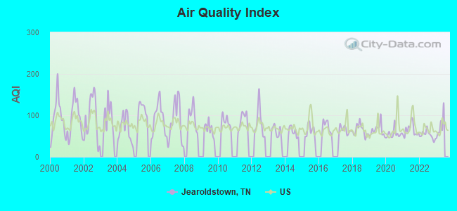
Air Quality Index (AQI) level in 2022 was 52.7. This is better than average.
| City: | 52.7 |
| U.S.: | 72.6 |
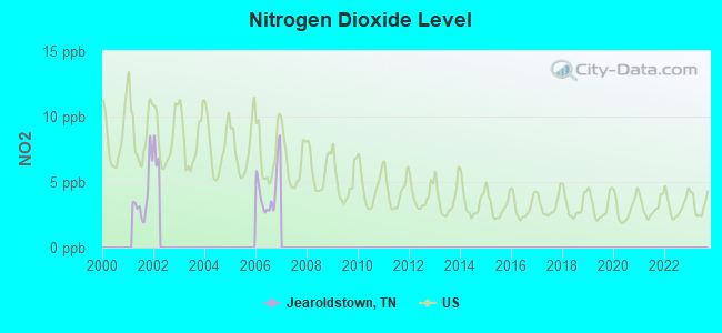
Nitrogen Dioxide (NO2) [ppb] level in 2006 was 4.41. This is about average. Closest monitor was 16.2 miles away from the city center.
| City: | 4.41 |
| U.S.: | 5.11 |
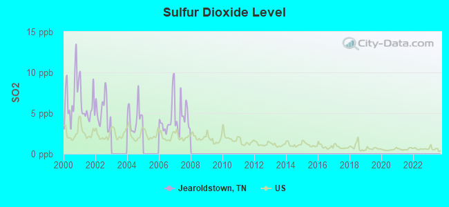
Sulfur Dioxide (SO2) [ppb] level in 2007 was 4.34. This is significantly worse than average. Closest monitor was 13.4 miles away from the city center.
| City: | 4.34 |
| U.S.: | 1.51 |
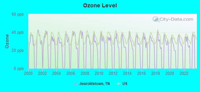
Ozone [ppb] level in 2022 was 29.1. This is about average. Closest monitor was 16.2 miles away from the city center.
| City: | 29.1 |
| U.S.: | 33.3 |
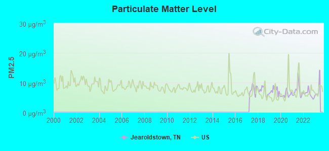
Particulate Matter (PM2.5) [µg/m3] level in 2022 was 6.10. This is better than average. Closest monitor was 16.7 miles away from the city center.
| City: | 6.10 |
| U.S.: | 8.11 |
Tornado activity:
Jearoldstown-area historical tornado activity is significantly below Tennessee state average. It is 70% smaller than the overall U.S. average.
On 7/10/1980, a category F3 (max. wind speeds 158-206 mph) tornado 22.0 miles away from the Jearoldstown place center injured 12 people and caused between $50,000 and $500,000 in damages.
On 3/12/1967, a category F2 (max. wind speeds 113-157 mph) tornado 6.7 miles away from the place center killed one person and injured 5 people and caused between $50,000 and $500,000 in damages.
Earthquake activity:
Jearoldstown-area historical earthquake activity is significantly above Tennessee state average. It is 34% greater than the overall U.S. average.On 8/9/2020 at 12:07:37, a magnitude 5.1 (5.1 MW, Depth: 4.7 mi, Class: Moderate, Intensity: VI - VII) earthquake occurred 89.9 miles away from the city center
On 7/27/1980 at 18:52:21, a magnitude 5.2 (5.1 MB, 4.7 MS, 5.0 UK, 5.2 UK) earthquake occurred 145.7 miles away from the city center
On 8/23/2011 at 17:51:04, a magnitude 5.8 (5.8 MW, Depth: 3.7 mi) earthquake occurred 284.1 miles away from Jearoldstown center
On 11/30/1973 at 07:48:41, a magnitude 4.7 (4.7 MB, 4.6 ML, Class: Light, Intensity: IV - V) earthquake occurred 80.0 miles away from the city center
On 8/2/1974 at 08:52:09, a magnitude 4.9 (4.3 MB, 4.9 LG) earthquake occurred 171.4 miles away from Jearoldstown center
On 11/23/2006 at 10:42:57, a magnitude 4.3 (4.3 MB) earthquake occurred 69.1 miles away from the city center
Magnitude types: regional Lg-wave magnitude (LG), body-wave magnitude (MB), local magnitude (ML), surface-wave magnitude (MS), moment magnitude (MW)
Natural disasters:
The number of natural disasters in Greene County (11) is smaller than the US average (15).Major Disasters (Presidential) Declared: 7
Emergencies Declared: 2
Causes of natural disasters: Floods: 7, Storms: 5, Winter Storms: 3, Flash Flood: 1, Heavy Rain: 1, Hurricane: 1, Ice Storm: 1, Landslide: 1, Mudslide: 1, Snowfall: 1, Tornado: 1, Wind: 1, Other: 1 (Note: some incidents may be assigned to more than one category).
Hospitals and medical centers near Jearoldstown:
- DURHAM-HENSLEY HEALTH AND REHABILITATION (Nursing Home, about 10 miles away; CHUCKEY, TN)
- FMC EASTERN TENNESSEE (Dialysis Facility, about 12 miles away; GREENEVILLE, TN)
- COMCARE INC TUSCULUM (Hospital, about 13 miles away; GREENEVILLE, TN)
- FOUR OAKS HEALTH CARE CENTER (Nursing Home, about 13 miles away; JONESBOROUGH, TN)
- CHURCH HILL CARE AND REHAB CTR (Nursing Home, about 13 miles away; CHURCH HILL, TN)
- LAUGHLIN HOME HEALTH AGENCY (Home Health Center, about 13 miles away; GREENEVILLE, TN)
- LAUGHLIN MEMORIAL HOSPITAL, INC Acute Care Hospitals (about 13 miles away; GREENEVILLE, TN)
Colleges/universities with over 2000 students nearest to Jearoldstown:
- Tusculum College (about 13 miles; Greeneville, TN; Full-time enrollment: 2,070)
- East Tennessee State University (about 19 miles; Johnson City, TN; FT enrollment: 12,774)
- Northeast State Community College (about 19 miles; Blountville, TN; FT enrollment: 4,480)
- Walters State Community College (about 33 miles; Morristown, TN; FT enrollment: 4,359)
- King University (about 35 miles; Bristol, TN; FT enrollment: 2,472)
- Southeast Kentucky Community and Technical College (about 47 miles; Cumberland, KY; FT enrollment: 2,196)
- University of North Carolina at Asheville (about 51 miles; Asheville, NC; FT enrollment: 3,312)
Points of interest:
Notable locations in Jearoldstown: Clear Creek Mill (A), Newmansville Volunteer Fire Department (B). Display/hide their locations on the map
Churches in Jearoldstown include: Doty Chapel (A), Jearoldstown United Methodist Church (B), Liberty Hill United Methodist Church (C), Pine Grove Church (D), Bethany Church (E), Union Temple Church (F), Pleasant Hill Church (G), Bethesda Church (H), Oakdale Church (I). Display/hide their locations on the map
Cemetery: Moore Cemetery (1). Display/hide its location on the map
Streams, rivers, and creeks: Long Fork (A), Double Lick Branch (B), Crabtree Branch (C), Clear Creek (D), Bright Branch (E), Newmansville Creek (F). Display/hide their locations on the map
| This place: | 2.5 people |
| Tennessee: | 2.5 people |
| This place: | 68.7% |
| Whole state: | 69.8% |
| This place: | 4.5% |
| Whole state: | 4.2% |
Likely homosexual households (counted as self-reported same-sex unmarried-partner households)
- Lesbian couples: 0.2% of all households
- Gay men: 0.1% of all households
| This place: | 11.0% |
| Whole state: | 13.5% |
| This place: | 5.0% |
| Whole state: | 5.8% |
For population 15 years and over in Jearoldstown:
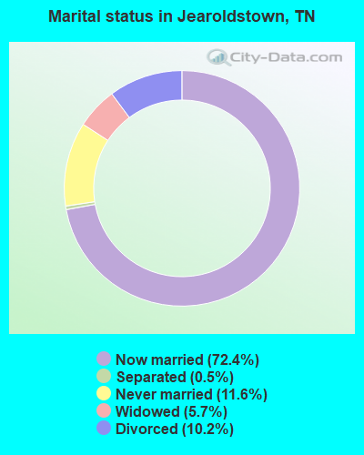
- Never married: 11.6%
- Now married: 72.4%
- Separated: 0.5%
- Widowed: 5.7%
- Divorced: 10.2%
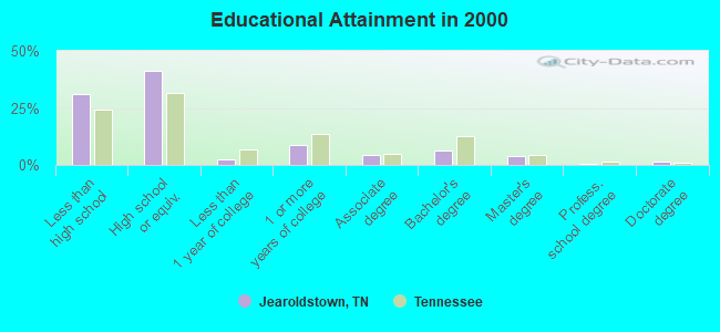
For population 25 years and over in Jearoldstown:
- High school or higher: 69.2%
- Bachelor's degree or higher: 12.2%
- Graduate or professional degree: 5.7%
- Unemployed: 6.1%
- Mean travel time to work (commute): 28.5 minutes
| Here: | 13.4 |
| Tennessee average: | 13.3 |
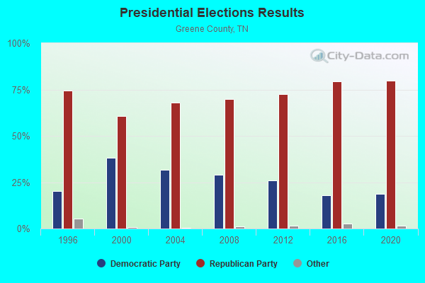
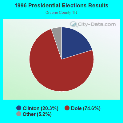
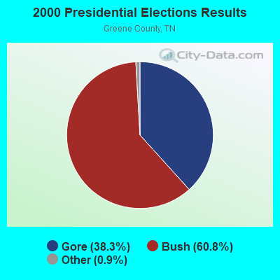

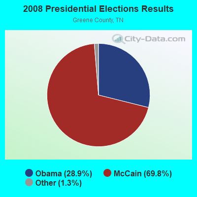

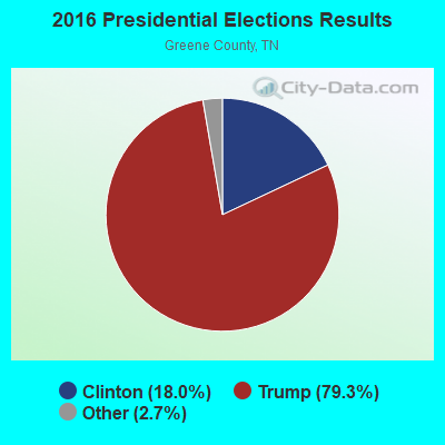
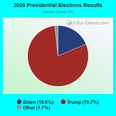
Graphs represent county-level data. Detailed 2008 Election Results
Religion statistics for Jearoldstown, TN (based on Greene County data)
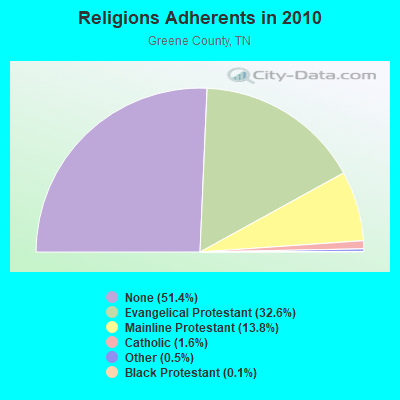

| Religion | Adherents | Congregations |
|---|---|---|
| Evangelical Protestant | 22,449 | 110 |
| Mainline Protestant | 9,496 | 74 |
| Catholic | 1,094 | 1 |
| Other | 326 | 2 |
| Black Protestant | 95 | 1 |
| None | 35,371 | - |
Food Environment Statistics:
| Greene County: | 1.67 / 10,000 pop. |
| Tennessee: | 1.99 / 10,000 pop. |
| Greene County: | 0.46 / 10,000 pop. |
| Tennessee: | 0.65 / 10,000 pop. |
| Here: | 6.68 / 10,000 pop. |
| State: | 5.16 / 10,000 pop. |
| This county: | 5.16 / 10,000 pop. |
| State: | 6.56 / 10,000 pop. |
| Greene County: | 11.3% |
| Tennessee: | 11.4% |
| This county: | 31.2% |
| Tennessee: | 30.2% |
| Greene County: | 11.9% |
| Tennessee: | 13.5% |
Strongest AM radio stations in Jearoldstown:
- WPWT (870 AM; daytime; 10 kW; COLONIAL HEIGHTS, TN; Owner: INFORMATION COMMUNICATIONS CORP.)
- WKTP (1590 AM; 10 kW; JONESBOROUGH, TN; Owner: HOLSTON VALLEY BROADCASTING CORP.)
- WGOC (640 AM; 10 kW; BLOUNTVILLE, TN; Owner: CITADEL BROADCASTING COMPANY)
- WHGG (1090 AM; daytime; 10 kW; KINGSPORT, TN; Owner: APPALACHIAN EDUCATIONAL COMMUNICATIO)
- WJCW (910 AM; 5 kW; JOHNSON CITY, TN; Owner: CITADEL BROADCASTING COMPANY)
- WETB (790 AM; 5 kW; JOHNSON CITY, TN; Owner: MOUNTAIN SIGNALS, INC.)
- WFGW (1010 AM; 50 kW; BLACK MOUNTAIN, NC; Owner: BLUE RIDGE BROADCASTING CORP.)
- WKIN (1320 AM; 5 kW; KINGSPORT, TN; Owner: CITADEL BROADCASTING COMPANY)
- WZAP (690 AM; 10 kW; BRISTOL, VA; Owner: RAM COMMUNICATIONS, INC.)
- WKVL (850 AM; daytime; 50 kW; KNOXVILLE, TN; Owner: HORNE RADIO, LLC)
- WEMB (1420 AM; 5 kW; ERWIN, TN; Owner: W E M B, INC.)
- WKJV (1380 AM; 25 kW; ASHEVILLE, NC; Owner: INTERNATIONAL BAPTIST OUTREACH MISSIONS)
- WLFJ (660 AM; daytime; 50 kW; GREENVILLE, SC; Owner: CLEAR CHANNEL BROADCASTING LICENSES, INC.)
Strongest FM radio stations in Jearoldstown:
- WTFM (98.5 FM; KINGSPORT, TN; Owner: HOLSTON VALLEY BROADCASTING CORP.)
- WRZK (95.9 FM; COLONIAL HEIGHTS, TN; Owner: MURRAY COMMUNICATIONS)
- WCSK (90.3 FM; KINGSPORT, TN; Owner: KINGSPORT CITY SCHOOLS BD. OF EDUC .)
- WQUT (101.5 FM; JOHNSON CITY, TN; Owner: CITADEL BROADCASTING COMPANY)
- WPJO (99.3 FM; ELIZABETHTON, TN; Owner: BRISTOL BROADCASTING COMPANY, INC.)
- WHCB (91.5 FM; BRISTOL, TN; Owner: APPALACHIAN EDUC. COMMUNICATION CORP)
- WETS-FM (89.5 FM; JOHNSON CITY, TN; Owner: EAST TENNESSEE STATE UNIVERSITY)
- WAEZ (94.9 FM; GREENEVILLE, TN; Owner: BRISTOL BROADCASTING COMPANY, INC.)
- WXBQ-FM (96.9 FM; BRISTOL, TN; Owner: BRISTOL BROADCASTING COMPANY, INC.)
- WJDT (106.5 FM; ROGERSVILLE, TN; Owner: C & S BROADCASTING)
- W214AP (90.7 FM; JOHNSON CITY, TN; Owner: THE MOODY BIBLE INSTITUTE OF CHICAGO)
- WCQR-FM (88.3 FM; KINGSPORT, TN; Owner: POSITIVE ALTERNATIVE RADIO, INC.)
- WMIT (106.9 FM; BLACK MOUNTAIN, NC; Owner: BLUE RIDGE BROADCASTING CORPORATION)
- WNCW (88.7 FM; SPINDALE, NC; Owner: ISOTHERMAL COMMUNITY COLLEGE)
- WBGQ (100.7 FM; BULLS GAP, TN; Owner: CHEROKEE BROADCASTING)
- WAXM (93.5 FM; BIG STONE GAP, VA; Owner: VALLEY BROADCASTING, INC.)
- WEYE (104.3 FM; SURGOINSVILLE, TN; Owner: TRI-CITY RADIO, LLC)
- W223AA (92.5 FM; BIG STONE GAP, VA; Owner: VALLEY BROADCASTING, INC.)
- WECR-FM (102.3 FM; BEECH MOUNTAIN, NC; Owner: RONDINARO BROADCASTING, INC)
- WSEH (102.7 FM; CUMBERLAND, KY; Owner: CUMBERLAND CITY BROADCASTING, INC.)
TV broadcast stations around Jearoldstown:
- WCYB-TV (Channel 5; BRISTOL, VA; Owner: APPALACHIAN BROADCASTING CORP.)
- WASV-TV (Channel 62; ASHEVILLE, NC; Owner: MEDIA GENERAL BROADCASTING OF SOUTH CAROLINA HOLDINGS, INC.)
- WKPT-LP (Channel 25; KINGSPORT, TN; Owner: HOLSTON VALLEY BROADCASTING CORP.)
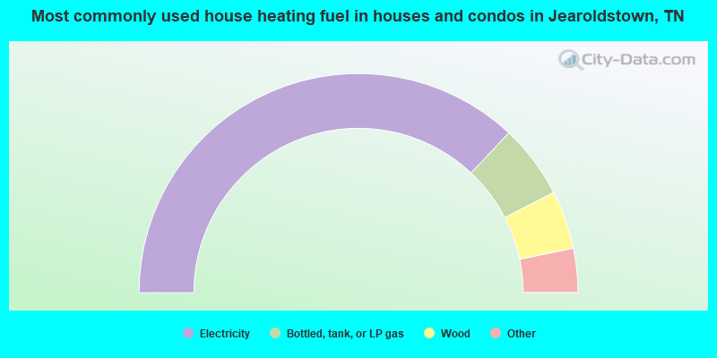
- 74.1%Electricity
- 10.9%Bottled, tank, or LP gas
- 8.6%Wood
- 2.4%Fuel oil, kerosene, etc.
- 1.6%Coal or coke
- 1.2%No fuel used
- 0.7%Other fuel
- 0.6%Utility gas
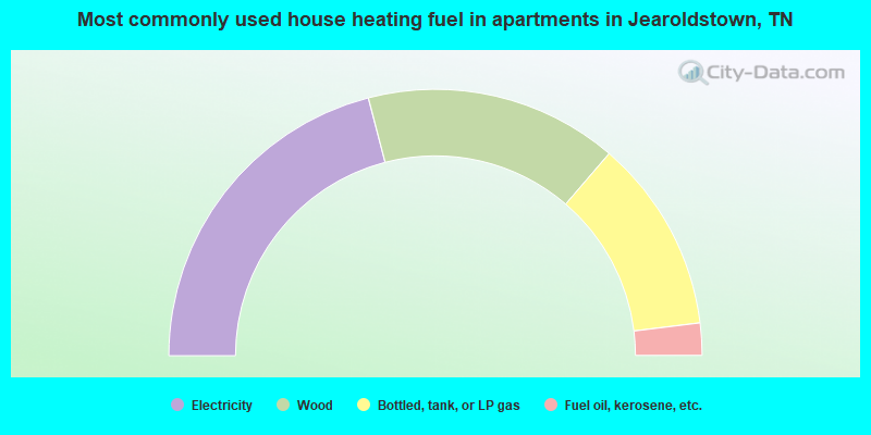
- 41.9%Electricity
- 30.7%Wood
- 23.5%Bottled, tank, or LP gas
- 3.9%Fuel oil, kerosene, etc.
Jearoldstown compared to Tennessee state average:
- Unemployed percentage below state average.
- Black race population percentage significantly below state average.
- Hispanic race population percentage significantly below state average.
- Foreign-born population percentage significantly below state average.
- Renting percentage significantly below state average.
- Length of stay since moving in significantly above state average.
- Number of rooms per house significantly below state average.
- House age significantly below state average.
- Number of college students below state average.
- Percentage of population with a bachelor's degree or higher below state average.