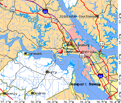
Jamestown district, Virginia
Submit your own pictures of this city and show them to the world
- OSM Map
- General Map
- Google Map
- MSN Map
| Males: 5,697 | |
| Females: 6,229 |
| Median resident age: | 41.8 years |
| Virginia median age: | 35.7 years |
Zip code: 23185
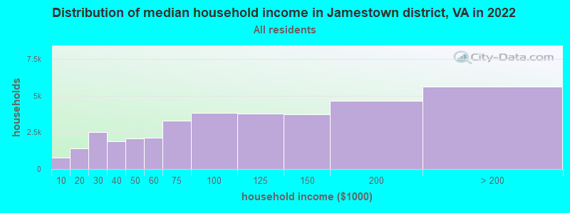
| Jamestown district: | $109,038 |
| VA: | $85,873 |
Estimated per capita income in 2022: $55,804 (it was $31,787 in 2000)
Jamestown district income, earnings, and wages data
Estimated median house or condo value in 2022: $453,872 (it was $177,000 in 2000)
| Jamestown district: | $453,872 |
| VA: | $365,700 |
Mean prices in 2022: all housing units: $452,571; detached houses: $493,501; townhouses or other attached units: $297,262; in 3-to-4-unit structures: $316,057; in 5-or-more-unit structures: $301,058; mobile homes: $66,968
Jamestown district, VA residents, houses, and apartments details
Detailed information about poverty and poor residents in Jamestown district, VA
Compare current foreclosures near Jamestown district, VA:
| Photo | Address | Area | Beds / Baths | Price | Details |
|---|---|---|---|---|---|

|
#1
Richwine Dr
Williamsburg, VA 23185
|
1,441 sq. feet
|
1 baths 3 beds |
show details | |

|
#2
Palace Ct
Newport News, VA 23608
|
1,474 sq. feet
|
2 baths 3 beds |
show details | |

|
#3
Springwell Pl
Newport News, VA 23608
|
1,809 sq. feet
|
2 baths 3 beds |
show details | |

|
#4
Shelly Rd
Hayes, VA 23072
|
1,400 sq. feet
|
2 baths 3 beds |
show details | |

|
#5
Trafalgar Ct
Williamsburg, VA 23185
|
2,774 sq. feet
|
2 baths 4 beds |
show details | |

|
#6
Spring Trce
Williamsburg, VA 23188
|
1,392 sq. feet
|
1 baths 2 beds |
show details | |

|
#7
Marvin Dr
Newport News, VA 23608
|
1,754 sq. feet
|
2 baths 3 beds |
show details | |

|
#8
Allyson Dr
Williamsburg, VA 23188
|
1,273 sq. feet
|
2 baths 3 beds |
show details | |

|
#9
Algonquin Trl
Williamsburg, VA 23185
|
1,384 sq. feet
|
2 baths 3 beds |
show details | |

|
#10
Algonquin Trl
Williamsburg, VA 23185
|
1,650 sq. feet
|
2 baths 3 beds |
show details |
| Photo | Address | Area | Beds / Baths | Price | Details |
|---|---|---|---|---|---|

|
#11
Carters Neck Rd
Williamsburg, VA 23188
|
3,856 sq. feet
|
3 baths 5 beds |
show details | |

|
#12
Burwell Ct
Williamsburg, VA 23185
|
3,998 sq. feet
|
3 baths 4 beds |
show details | |

|
#13
Bolden Dr
Hayes, VA 23072
|
1,738 sq. feet
|
2 baths 3 beds |
show details | |

|
#14
Doewood Ln
Newport News, VA 23608
|
1,703 sq. feet
|
2 baths 3 beds |
show details | |

|
#15
Sand Hill Rd
Williamsburg, VA 23188
|
1,622 sq. feet
|
2 baths 3 beds |
show details | |

|
#16
Ninebark Ct
Newport News, VA 23608
|
1,454 sq. feet
|
1 baths 2 beds |
show details | |

|
#17
My Way Ln
Gloucester, VA 23061
|
2,540 sq. feet
|
2 baths 4 beds |
show details | |

|
#18
N Hall Way
Newport News, VA 23608
|
1,808 sq. feet
|
2 baths 4 beds |
show details | |

|
#19
Wythe St
Newport News, VA 23608
|
1,979 sq. feet
|
2 baths 4 beds |
show details | |

|
#20
Olde Towne Run
Newport News, VA 23608
|
1,424 sq. feet
|
2 baths 3 beds |
show details |
| Photo | Address | Area | Beds / Baths | Price | Details |
|---|---|---|---|---|---|

|
#21
Lees Mill Dr
Newport News, VA 23608
|
1,428 sq. feet
|
2 baths 2 beds |
show details | |

|
#22
Old Bridge Rd
Newport News, VA 23608
|
1,428 sq. feet
|
2 baths 2 beds |
show details | |

|
#23
Holly Fork Rd
Barhamsville, VA 23011
|
725 sq. feet
|
1 baths 2 beds |
show details | |

|
#24
Nicewood Dr
Newport News, VA 23602
|
1,053 sq. feet
|
1 baths 3 beds |
show details | |

|
#25
Everett Dr
Newport News, VA 23602
|
1,340 sq. feet
|
2 baths 3 beds |
show details | |

|
#26
Rexford Dr
Newport News, VA 23608
|
1,714 sq. feet
|
1 baths 3 beds |
show details | |

|
#27
Whitewater Dr
Newport News, VA 23608
|
1,307 sq. feet
|
2 baths 3 beds |
show details | |

|
#28
Fort Huger Dr
Smithfield, VA 23430
|
1,152 sq. feet
|
2 baths 3 beds |
show details | |

|
#29
Whitewater Dr
Newport News, VA 23608
|
1,307 sq. feet
|
2 baths 3 beds |
show details | |

|
#30
Astor Dr
Newport News, VA 23608
|
1,582 sq. feet
|
2 baths 3 beds |
show details |
| Photo | Address | Area | Beds / Baths | Price | Details |
|---|---|---|---|---|---|

|
#31
Old Colonial Way Unit 102
Newport News, VA 23608
|
1,031 sq. feet
|
2 baths 2 beds |
show details | |

|
#32
Rivers Ridge Cir
Newport News, VA 23608
|
1,316 sq. feet
|
2 baths 3 beds |
show details | |

|
#33
Longfellow Dr
Newport News, VA 23602
|
1,050 sq. feet
|
1 baths 3 beds |
show details | |

|
#34
Rivers Ridge Cir
Newport News, VA 23608
|
1,392 sq. feet
|
2 baths 3 beds |
show details | |

|
#35
Spring Rd
Yorktown, VA 23690
|
950 sq. feet
|
1 baths 3 beds |
show details | |

|
#36
Williamson Park Dr # A
Newport News, VA 23608
|
1,035 sq. feet
|
2 baths 2 beds |
show details | |

|
#37
Coleman Dr
Gloucester Point, VA 23062
|
2,061 sq. feet
|
2 baths 3 beds |
show details | |

|
#38
Lees Mill Dr
Newport News, VA 23608
|
1,258 sq. feet
|
2 baths 2 beds |
show details | |

|
#39
Lees Mill Dr
Newport News, VA 23608
|
1,258 sq. feet
|
2 baths 2 beds |
show details | |

|
#40
Circle Dr
Hayes, VA 23072
|
1,697 sq. feet
|
2 baths 3 beds |
show details |
| Photo | Address | Area | Beds / Baths | Price | Details |
|---|---|---|---|---|---|

|
#41
Revolution Ln
Newport News, VA 23608
|
1,979 sq. feet
|
2 baths 4 beds |
show details | |

|
#42
Belroi Rd
Gloucester, VA 23061
|
1,474 sq. feet
|
1 baths 3 beds |
show details | |

|
#43
Oneonta Dr
Newport News, VA 23602
|
960 sq. feet
|
1 baths 2 beds |
show details | |

|
#44
Egret Ct
Newport News, VA 23608
|
1,666 sq. feet
|
2 baths 3 beds |
show details | |

|
#45
Tanbark Ln
Williamsburg, VA 23188
|
2,662 sq. feet
|
3 baths 4 beds |
show details | |

|
#46
Sherbrooke Dr
Newport News, VA 23602
|
2,225 sq. feet
|
2 baths 3 beds |
show details | |

|
#47
Stanley Dr
Newport News, VA 23608
|
1,586 sq. feet
|
2 baths 3 beds |
show details | |

|
#48
Ashton Green Blvd
Newport News, VA 23608
|
1,214 sq. feet
|
2 baths 3 beds |
show details | |

|
#49
Colony Rd
Newport News, VA 23602
|
967 sq. feet
|
1 baths 3 beds |
show details | |

|
Check over 1 million property listings on Foreclosure.com!
|
browse all offers | |||

- 8,59891.1%White alone
- 4184.4%Black alone
- 1451.5%Hispanic
- 1201.3%Two or more races
- 1161.2%Asian alone
- 210.2%American Indian alone
- 160.2%Other race alone
- 40.04%Native Hawaiian and Other
Pacific Islander alone
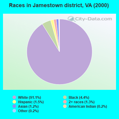
Races in Jamestown district detailed stats: ancestries, foreign born residents, place of birth
 Recent articles from our blog. Our writers, many of them Ph.D. graduates or candidates, create easy-to-read articles on a wide variety of topics.
Current Local Time: EST time zone
Land area: 14.4 square miles.
Population density: 826 people per square mile (low).
| Jamestown district: | 0.8% ($1,348) |
| Virginia: | 1.0% ($1,143) |
Nearest city with pop. 50,000+: Newport News, VA  (18.7 miles , pop. 180,150).
Nearest city with pop. 200,000+: Norfolk, VA (36.4 miles , pop. 234,403).
Nearest city with pop. 1,000,000+: Philadelphia, PA (209.7 miles , pop. 1,517,550).
Nearest cities:
), ), ), )Latitude: 37.24 N, Longitude: 76.75 W
Area code commonly used in this area: 757

| Here: | 2.6% |
| Virginia: | 2.7% |

- Educational services (13.8%)
- Accommodation & food services (10.6%)
- Arts, entertainment, recreation (7.8%)
- Health care (7.5%)
- Construction (6.5%)
- Professional, scientific, technical services (5.4%)
- Public administration (5.4%)
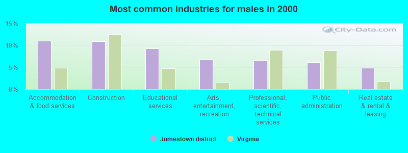
- Accommodation & food services (11.0%)
- Construction (10.9%)
- Educational services (9.3%)
- Arts, entertainment, recreation (6.9%)
- Professional, scientific, technical services (6.6%)
- Public administration (6.2%)
- Real estate & rental & leasing (4.9%)
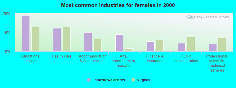
- Educational services (19.1%)
- Health care (12.2%)
- Accommodation & food services (10.0%)
- Arts, entertainment, recreation (9.0%)
- Finance & insurance (5.2%)
- Public administration (4.4%)
- Professional, scientific, technical services (4.0%)
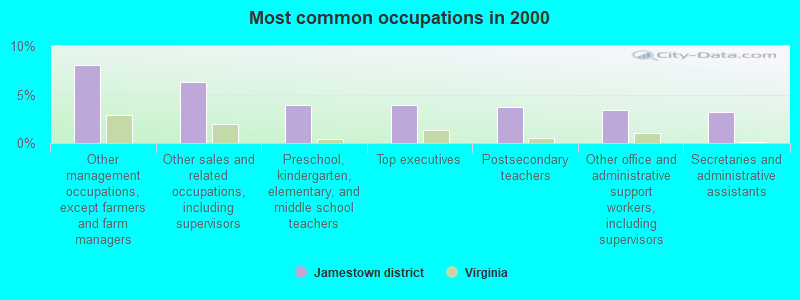
- Other management occupations, except farmers and farm managers (8.0%)
- Other sales and related occupations, including supervisors (6.3%)
- Preschool, kindergarten, elementary, and middle school teachers (3.9%)
- Top executives (3.9%)
- Postsecondary teachers (3.7%)
- Other office and administrative support workers, including supervisors (3.4%)
- Secretaries and administrative assistants (3.2%)
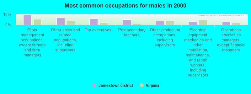
- Other management occupations, except farmers and farm managers (9.5%)
- Other sales and related occupations, including supervisors (7.0%)
- Top executives (6.2%)
- Postsecondary teachers (5.0%)
- Other production occupations, including supervisors (3.5%)
- Electrical equipment mechanics and other installation, maintenance, and repair workers, including supervisors (3.4%)
- Operations specialties managers, except financial managers (2.9%)
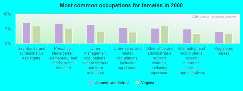
- Secretaries and administrative assistants (6.9%)
- Preschool, kindergarten, elementary, and middle school teachers (6.6%)
- Other management occupations, except farmers and farm managers (6.4%)
- Other sales and related occupations, including supervisors (5.5%)
- Other office and administrative support workers, including supervisors (5.2%)
- Information and record clerks, except customer service representatives (4.9%)
- Registered nurses (4.0%)
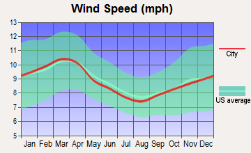
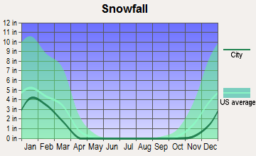
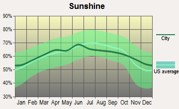
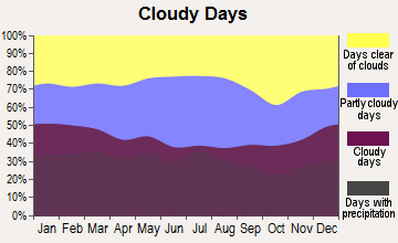
Average climate in Jamestown district, Virginia
Based on data reported by over 4,000 weather stations
(lower is better)
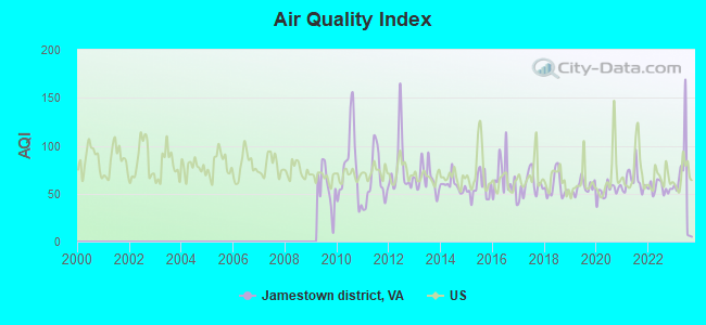
Air Quality Index (AQI) level in 2023 was 57.6. This is better than average.
| City: | 57.6 |
| U.S.: | 72.6 |
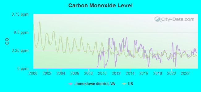
Carbon Monoxide (CO) [ppm] level in 2023 was 0.229. This is about average. Closest monitor was 17.5 miles away from the city center.
| City: | 0.229 |
| U.S.: | 0.251 |
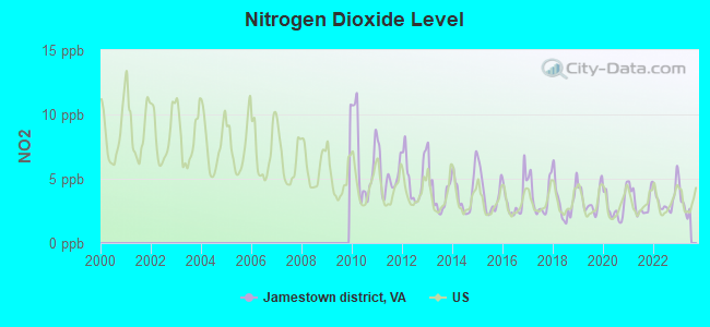
Nitrogen Dioxide (NO2) [ppb] level in 2022 was 3.40. This is significantly better than average. Closest monitor was 17.7 miles away from the city center.
| City: | 3.40 |
| U.S.: | 5.11 |
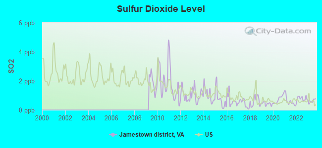
Sulfur Dioxide (SO2) [ppb] level in 2023 was 0.617. This is significantly better than average. Closest monitor was 15.0 miles away from the city center.
| City: | 0.617 |
| U.S.: | 1.515 |
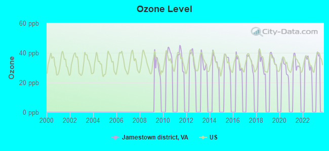
Ozone [ppb] level in 2022 was 32.9. This is about average. Closest monitor was 17.7 miles away from the city center.
| City: | 32.9 |
| U.S.: | 33.3 |
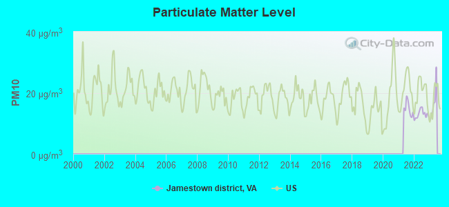
Particulate Matter (PM10) [µg/m3] level in 2022 was 13.0. This is significantly better than average. Closest monitor was 17.7 miles away from the city center.
| City: | 13.0 |
| U.S.: | 19.2 |
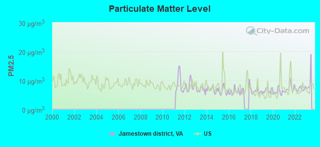
Particulate Matter (PM2.5) [µg/m3] level in 2022 was 7.05. This is about average. Closest monitor was 17.7 miles away from the city center.
| City: | 7.05 |
| U.S.: | 8.11 |
Tornado activity:
Jamestown district-area historical tornado activity is slightly above Virginia state average. It is 16% smaller than the overall U.S. average.
On 8/6/1993, a category F4 (max. wind speeds 207-260 mph) tornado 29.1 miles away from the Jamestown district city center killed 4 people and injured 246 people and caused between $5,000,000 and $50,000,000 in damages.
On 10/14/1986, a category F3 (max. wind speeds 158-206 mph) tornado 10.0 miles away from the city center caused between $50,000 and $500,000 in damages.
Earthquake activity:
Jamestown district-area historical earthquake activity is significantly above Virginia state average. It is 59% smaller than the overall U.S. average.On 8/23/2011 at 17:51:04, a magnitude 5.8 (5.8 MW, Depth: 3.7 mi, Class: Moderate, Intensity: VI - VII) earthquake occurred 79.9 miles away from the city center
On 12/9/2003 at 20:59:14, a magnitude 4.5 (4.5 MB, 4.5 LG, Class: Light, Intensity: IV - V) earthquake occurred 67.7 miles away from Jamestown district center
On 8/25/2011 at 05:07:52, a magnitude 4.5 (4.5 ML, Depth: 4.2 mi) earthquake occurred 82.7 miles away from Jamestown district center
On 12/9/2003 at 20:59:18, a magnitude 4.5 (4.5 ML, Depth: 6.2 mi) earthquake occurred 82.8 miles away from Jamestown district center
On 8/9/2020 at 12:07:37, a magnitude 5.1 (5.1 MW, Depth: 4.7 mi) earthquake occurred 246.0 miles away from the city center
On 8/24/2011 at 00:04:36, a magnitude 4.2 (4.2 ML) earthquake occurred 80.9 miles away from the city center
Magnitude types: regional Lg-wave magnitude (LG), body-wave magnitude (MB), local magnitude (ML), moment magnitude (MW)
Natural disasters:
The number of natural disasters in James City County (14) is near the US average (15).Major Disasters (Presidential) Declared: 9
Emergencies Declared: 4
Causes of natural disasters: Hurricanes: 7, Tropical Storms: 2, Winter Storms: 2, Blizzard: 1, Flood: 1, Storm: 1, Tropical Depression: 1, Other: 1 (Note: some incidents may be assigned to more than one category).
Hospitals and medical centers near Jamestown district:
- RAI - JOHN TYLER HWY-WILLIAMSBURG (Dialysis Facility, about 2 miles away; WILLIAMSBURG, VA)
- WOODHAVEN HALL AT WILLIAMSBURG LANDING (Nursing Home, about 2 miles away; WILLIAMSBURG, VA)
- CONSULATE HEALTHCARE OF WILLIAMSBURG (Nursing Home, about 2 miles away; WILLIAMSBURG, VA)
- SENTARA HOME CARE SERVICES - WILLIAMSBURG (Hospital, about 2 miles away; WILLIAMSBURG, VA)
- EASTERN STATE HOSPITAL Acute Care Hospitals (about 3 miles away; WILLIAMSBURG, VA)
- PINES CONVALESCENT CENTER (Nursing Home, about 4 miles away; WILLIAMSBURG, VA)
- THE CONVALESCENT CENTER AT PATRIOTS COLONY (Nursing Home, about 4 miles away; WILLIAMSBURG, VA)
Amtrak station near Jamestown district:
- 4 miles: WILLIAMSBURG (468 N. BOUNDARY ST.) . Services: ticket office, partially wheelchair accessible, enclosed waiting area, public restrooms, public payphones, vending machines, free short-term parking, free long-term parking, car rental agency, call for taxi service, intercity bus service, public transit connection.
Operable nuclear power plants near Jamestown district:
- 19 miles: Surry 1 and 2 in Newport News, VA.
Colleges/universities with over 2000 students nearest to Jamestown district:
- College of William and Mary (about 4 miles; Williamsburg, VA; Full-time enrollment: 7,617)
- Christopher Newport University (about 19 miles; Newport News, VA; FT enrollment: 5,061)
- Thomas Nelson Community College (about 22 miles; Hampton, VA; FT enrollment: 7,056)
- Hampton University (about 28 miles; Hampton, VA; FT enrollment: 4,494)
- Old Dominion University (about 35 miles; Norfolk, VA; FT enrollment: 19,825)
- Virginia State University (about 37 miles; Petersburg, VA; FT enrollment: 5,815)
- John Tyler Community College (about 37 miles; Chester, VA; FT enrollment: 5,864)
Points of interest:
Notable locations in Jamestown district: Four-H Camp (A), Williamsburg Office Park (B), Jamestown Beach Campground (C), First Settlers Campground (D), Camp Lightfoot (E), James City County Fire Department / Ambulance Station 3 (F), Archaearium (G), Glass House (H), James City Law Enforcement (I), James City County Police Department (J), Riverside Healthcare Center - Doctors Surgery Center (K), Williamsburg Landing Retirement Community (L), Williamsburg Winery (M). Display/hide their locations on the map
Shopping Centers: Williamsburg Crossing Shopping Center (1), Colony Square Shopping Center (2). Display/hide their locations on the map
Church in Jamestown district: Saint Martins Church (A). Display/hide its location on the map
Cemetery: Travis Cemetery (1). Display/hide its location on the map
Lakes, reservoirs, and swamps: Passmore Creek (A), Sandy Bay (B), Lake Pasbehegh (C), Lake Powell (D), Pitch and Tar Swamp (E), Back River Marsh (F). Display/hide their locations on the map
Creeks: Powhatan Creek (A), Mill Creek (B), Kingsmill Creek (C), Halfway Creek (D), College Creek (E). Display/hide their locations on the map
Park in Jamestown district: Jamestown Festival Park (1). Display/hide its location on the map
| This city: | 2.4 people |
| Virginia: | 2.5 people |
| This city: | 68.3% |
| Whole state: | 67.0% |
| This city: | 3.6% |
| Whole state: | 5.7% |
Likely homosexual households (counted as self-reported same-sex unmarried-partner households)
- Lesbian couples: 0.5% of all households
- Gay men: 0.3% of all households
| This city: | 3.9% |
| Whole state: | 9.6% |
| This city: | 1.5% |
| Whole state: | 4.3% |
114 people in other noninstitutional group quarters in 2000
For population 15 years and over in Jamestown district:
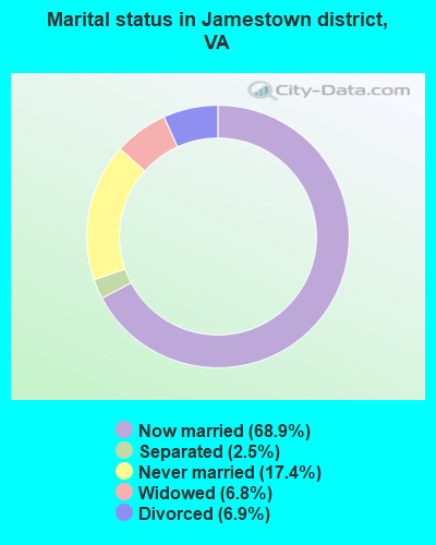
- Never married: 17.4%
- Now married: 68.9%
- Separated: 2.5%
- Widowed: 6.8%
- Divorced: 6.9%
For population 25 years and over in Jamestown district:
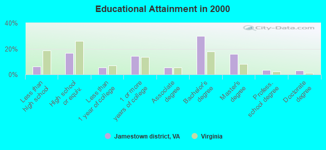
- High school or higher: 93.9%
- Bachelor's degree or higher: 52.4%
- Graduate or professional degree: 22.5%
- Unemployed: 3.0%
- Mean travel time to work (commute): 22.3 minutes
| Here: | 10.1 |
| Virginia average: | 13.4 |
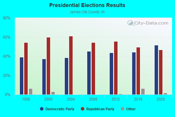
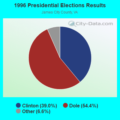
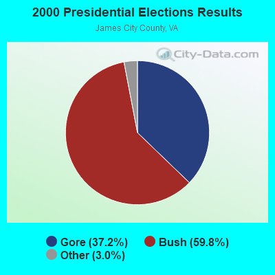
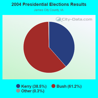
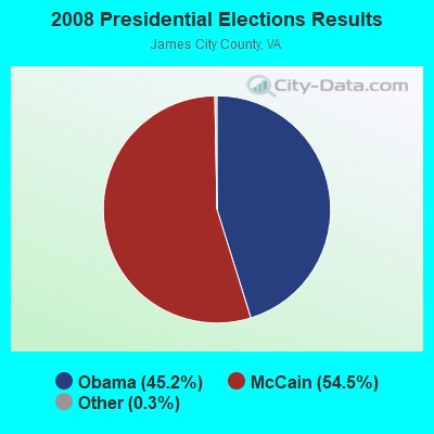
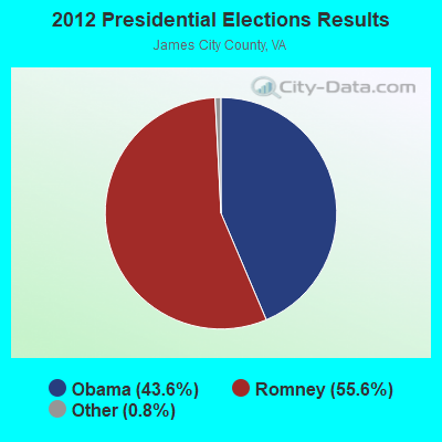
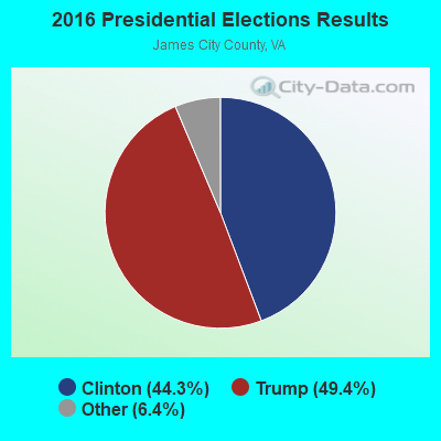
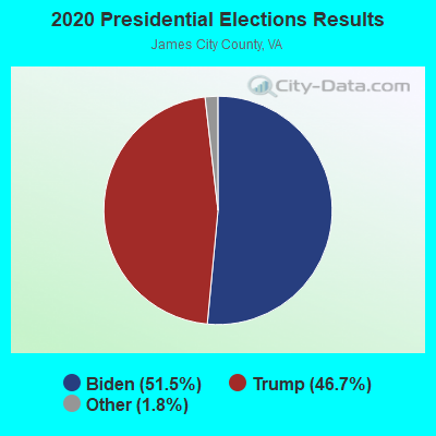
Graphs represent county-level data. Detailed 2008 Election Results
Religion statistics for Jamestown district, VA (based on James City County data)
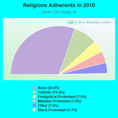
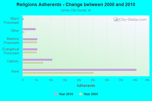
| Religion | Adherents | Congregations |
|---|---|---|
| Catholic | 10,601 | 2 |
| Evangelical Protestant | 5,322 | 22 |
| Mainline Protestant | 5,312 | 11 |
| Other | 4,672 | 5 |
| Black Protestant | 477 | 3 |
| None | 40,625 | - |
Food Environment Statistics:
| James City County: | 0.98 / 10,000 pop. |
| State: | 2.03 / 10,000 pop. |
| James City County: | 1.15 / 10,000 pop. |
| Virginia: | 1.43 / 10,000 pop. |
| This county: | 2.78 / 10,000 pop. |
| Virginia: | 4.03 / 10,000 pop. |
| This county: | 7.04 / 10,000 pop. |
| Virginia: | 7.65 / 10,000 pop. |
| Here: | 8.9% |
| Virginia: | 9.3% |
| James City County: | 26.1% |
| Virginia: | 26.7% |
| This county: | 16.4% |
| Virginia: | 18.6% |
11.52% of this county's 2021 resident taxpayers lived in other counties in 2020 ($87,664 average adjusted gross income)
| Here: | 11.52% |
| Virginia average: | 10.16% |
0.15% of residents moved from foreign countries ($1,530 average AGI)
James City County: 0.15% Virginia average: 0.12%
Top counties from which taxpayers relocated into this county between 2020 and 2021:
| from Newport News city, VA | |
| from Williamsburg city, VA | |
| from York County, VA |
9.43% of this county's 2020 resident taxpayers moved to other counties in 2021 ($78,485 average adjusted gross income)
| Here: | 9.43% |
| Virginia average: | 10.20% |
0.07% of residents moved to foreign countries ($886 average AGI)
James City County: 0.07% Virginia average: 0.09%
Top counties to which taxpayers relocated from this county between 2020 and 2021:
| to York County, VA | |
| to Williamsburg city, VA | |
| to Newport News city, VA |
Strongest AM radio stations in Jamestown district:
- WTAR (850 AM; 50 kW; NORFOLK, VA; Owner: SINCLAIR COMMUNICATIONS)
- WRJR (670 AM; 20 kW; CLAREMONT, VA; Owner: CHESAPEAKE-PORTSMOUTH BROADCASTING CORPORATION)
- WKGM (940 AM; 10 kW; SMITHFIELD, VA; Owner: WKGM, INC.)
- WMBG (740 AM; 0 kW; WILLIAMSBURG, VA; Owner: WILLIAMSBURG'S RADIO STATION, INC.)
- WCKO (1110 AM; daytime; 50 kW; NORFOLK, VA; Owner: WORD BROADCASTING NETWORK, INC.)
- WRVA (1140 AM; 50 kW; RICHMOND, VA; Owner: CLEAR CHANNEL BROADCASTING LICENSES, INC.)
- WGH (1310 AM; 20 kW; NEWPORT NEWS, VA; Owner: CHESAPEAKE BAY BROADCASTING, LLC)
- WDZY (1290 AM; 25 kW; COLONIAL HEIGHTS, VA; Owner: ABC, INC.)
- WPMH (1010 AM; 10 kW; PORTSMOUTH, VA; Owner: ABC, INC.)
- WGGM (820 AM; 10 kW; CHESTER, VA; Owner: HOFFMAN COMMUNICATIONS, INC.)
- WNIS (790 AM; 5 kW; NORFOLK, VA; Owner: COMMONWEALTH RADIO, L.L.C.)
- WWGB (1030 AM; daytime; 50 kW; INDIAN HEAD, MD; Owner: GOOD BODY MEDIA, LLC)
- WHKT (1650 AM; 10 kW; PORTSMOUTH, VA; Owner: ABC, INC.)
Strongest FM radio stations in Jamestown district:
- WAFX (106.9 FM; SUFFOLK, VA; Owner: TIDEWATER COMMUNICATIONS, LLC)
- WKLR (96.5 FM; FORT LEE, VA; Owner: COX RADIO, INC.)
- WHRO-FM (90.3 FM; NORFOLK, VA; Owner: HAMPTON ROADS EDUCATIONAL TELECOMMUNICATIONS ASSOCIATION,INC)
- WHRV (89.5 FM; NORFOLK, VA; Owner: HAMPTON ROADS EDUCATIONAL TELECOMMUNICATIONS ASSOCIATION,INC)
- WYCS (91.5 FM; YORKTOWN, VA; Owner: CREATIVE EDUCATIONAL MEDIA CORP. INC.)
- W261CN (100.1 FM; WILLIAMSBURG, VA; Owner: CSN INTERNATIONAL)
- WCWM (90.7 FM; WILLIAMSBURG, VA; Owner: THE COLLEGE OF WILLIAM & MARY IN VA.)
- WWBR (107.9 FM; WEST POINT, VA; Owner: WINNER BROADCASTING, LLC)
- WVKL (95.7 FM; NORFOLK, VA; Owner: ENTERCOM NORFOLK LICENSE, LLC)
- WXGM-FM (99.1 FM; GLOUCESTER, VA; Owner: WXGM, INC.)
- WJCD (107.7 FM; WINDSOR, VA; Owner: CLEAR CHANNEL BROADCASTING LICENSES, INC.)
- WXEZ (94.1 FM; YORKTOWN, VA; Owner: CHESAPEAKE BAY BROADCASTING, LLC)
- WSRV (92.3 FM; DELTAVILLE, VA; Owner: BULLSEYE BROADCASTING, LLC)
- WGH-FM (97.3 FM; NEWPORT NEWS, VA; Owner: CHESAPEAKE BAY BROADCASTING, LLC)
- W271AD (102.1 FM; SMITHFIELD, VA; Owner: CSN INTERNATIONAL)
TV broadcast stations around Jamestown district:
- WYSJ-CA (Channel 31; YORKTOWN, VA; Owner: JBS, INC.)
- WTKR (Channel 3; NORFOLK, VA; Owner: NEW YORK TIMES MANAGEMENT SERVICES)
- WTVZ-TV (Channel 33; NORFOLK, VA; Owner: WTVZ LICENSEE, LLC)
- WHRO-TV (Channel 15; HAMPTON-NORFOLK, VA; Owner: HAMPTON ROADS EDUCATIONAL TELECOMMUNICATIONS ASSOC, INC.)
- WPXV (Channel 49; NORFOLK, VA; Owner: PAXSON COMMUNICATIONS LICENSE COMPANY, LLC)
- WVEC-TV (Channel 13; HAMPTON, VA; Owner: WVEC TELEVISION, INC.)
- WAVY-TV (Channel 10; PORTSMOUTH, VA; Owner: WAVY BROADCASTING, LLC)
- WGNT (Channel 27; PORTSMOUTH, VA; Owner: UPN TELEVISION STATIONS INC.)
- WVBT (Channel 43; VIRGINIA BEACH, VA; Owner: WAVY BROADCASTING, LLC)
- WCVE-TV (Channel 23; RICHMOND, VA; Owner: COMMONWEALTH PUBLIC BROADCASTING CORPORATION)
- W21AQ (Channel 21; HAMPTON, VA; Owner: THE UNION MISSION)
- W18BS (Channel 18; HAMPTON, VA; Owner: NATIONAL MINORITY T.V., INC.)
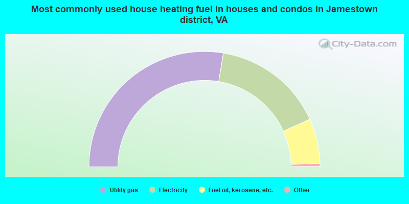
- 55.3%Utility gas
- 31.3%Electricity
- 12.6%Fuel oil, kerosene, etc.
- 0.5%Bottled, tank, or LP gas
- 0.3%Wood
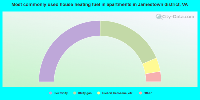
- 50.1%Electricity
- 37.1%Utility gas
- 7.3%Fuel oil, kerosene, etc.
- 3.2%Wood
- 1.3%Bottled, tank, or LP gas
- 0.9%Other fuel
Jamestown district compared to Virginia state average:
- Unemployed percentage significantly below state average.
- Black race population percentage significantly below state average.
- Hispanic race population percentage significantly below state average.
- Median age above state average.
- Foreign-born population percentage significantly below state average.
- Length of stay since moving in significantly above state average.
- Number of rooms per house significantly below state average.
- House age significantly below state average.
- Percentage of population with a bachelor's degree or higher above state average.
Jamestown district on our top lists:
- #10 on the list of "Top 101 cities with largest percentage of males in industries: beverage and tobacco products (population 5,000+)"
- #16 on the list of "Top 101 cities with largest percentage of males in occupations: postsecondary teachers (population 5,000+)"
- #18 on the list of "Top 101 cities with largest percentage of males in occupations: supervisors of transportation and material moving workers (population 5,000+)"
- #20 on the list of "Top 101 cities with largest percentage of males in occupations: judges, magistrates, and other judicial workers (population 5,000+)"
- #26 on the list of "Top 101 cities with largest percentage of females in occupations: transportation, tourism, and lodging attendants (population 5,000+)"
- #29 on the list of "Top 101 cities with largest percentage of females in occupations: air transportation workers (population 5,000+)"
- #36 on the list of "Top 101 cities with largest percentage of males in occupations: air transportation workers (population 5,000+)"
- #39 on the list of "Top 101 cities with largest percentage of males in industries: farm product raw materials merchant wholesalers (population 5,000+)"
- #50 on the list of "Top 101 cities with largest percentage of males in industries: miscellaneous durable goods merchant wholesalers (population 5,000+)"
- #53 on the list of "Top 101 cities with largest percentage of males in industries: book stores and news dealers (population 5,000+)"
- #61 on the list of "Top 101 cities with largest percentage of females in industries: health and personal care, except drug, stores (population 5,000+)"
- #86 on the list of "Top 101 cities with the most residents born in Other Northern America (population 500+)"
- #87 on the list of "Top 101 cities with largest percentage of males in industries: other direct selling establishments (population 5,000+)"
- #96 on the list of "Top 101 cities with largest percentage of males in industries: pharmacies and drug stores (population 5,000+)"
- #97 on the list of "Top 101 cities with largest percentage of females in industries: beverage and tobacco products (population 5,000+)"
- #101 on the list of "Top 101 cities with largest percentage of males in industries: retail florists (population 5,000+)"
- #12 (23185) on the list of "Top 101 zip codes with the most hotels or motels in 2005"
- #43 on the list of "Top 101 counties with the largest number of children under 18 without health insurance coverage in 2000"