Jamestown, Wisconsin
Submit your own pictures of this town and show them to the world
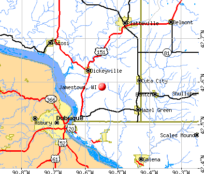
- OSM Map
- General Map
- Google Map
- MSN Map
Population change since 2000: -0.0%
 |
| Males: 1,055 | |
| Females: 1,021 |
| Median resident age: | 44.7 years |
| Wisconsin median age: | 42.6 years |
Zip codes: 53811.
| Jamestown: | $78,267 |
| WI: | $70,996 |
Estimated per capita income in 2022: $35,919 (it was $18,733 in 2000)
Jamestown town income, earnings, and wages data
Estimated median house or condo value in 2022: $240,347 (it was $101,500 in 2000)
| Jamestown: | $240,347 |
| WI: | $252,800 |
Detailed information about poverty and poor residents in Jamestown, WI


- 2,04598.5%White alone
- 190.9%Hispanic
- 80.4%Asian alone
- 40.2%Two or more races
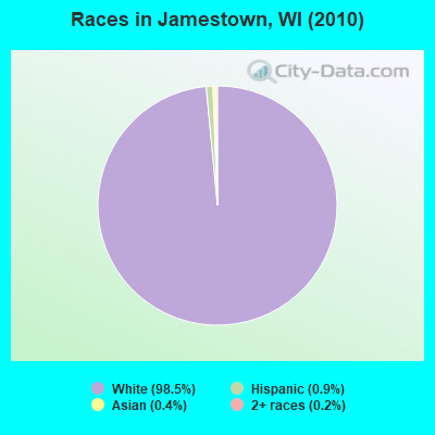
Races in Jamestown detailed stats: ancestries, foreign born residents, place of birth
 Recent articles from our blog. Our writers, many of them Ph.D. graduates or candidates, create easy-to-read articles on a wide variety of topics.

 | Moving back- Appleton area? (12 replies) |
| two rivers, wi- thoughts for family of lgbt member (48 replies) |
| Milwaukee one of the poorest cities in America (67 replies) |
| Moving to Kenosha Area (31 replies) |
| fitchburg? (14 replies) |
| Thinking about relocating to Green Bay or Sturgeon Bay from Upstate, NY. Please Help! (30 replies) |
Latest news from Jamestown, WI collected exclusively by city-data.com from local newspapers, TV, and radio stations
Ancestries: German (65.7%), Irish (14.0%), United States (6.8%), English (6.0%), Dutch (3.8%), Norwegian (1.8%).
Current Local Time: CST time zone
Elevation: 923 feet
Land area: 30.1 square miles.
Population density: 69 people per square mile (very low).
2 residents are foreign born
| This town: | 0.1% |
| Wisconsin: | 3.6% |
| Jamestown town: | 1.3% ($1,357) |
| Wisconsin: | 2.0% ($2,245) |
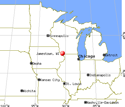
Nearest city with pop. 50,000+: Dubuque, IA  (5.9 miles , pop. 57,686).
Nearest city with pop. 200,000+: Madison, WI (70.7 miles , pop. 208,054).
Nearest city with pop. 1,000,000+: Chicago, IL (157.8 miles , pop. 2,896,016).
Nearest cities:
), ), ), ), ), )Latitude: 42.56 N, Longitude: 90.60 W


| Here: | 2.5% |
| Wisconsin: | 2.7% |
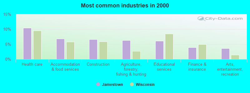
- Health care (10.5%)
- Accommodation & food services (6.8%)
- Construction (6.6%)
- Agriculture, forestry, fishing & hunting (6.3%)
- Educational services (6.1%)
- Finance & insurance (3.9%)
- Arts, entertainment, recreation (3.6%)
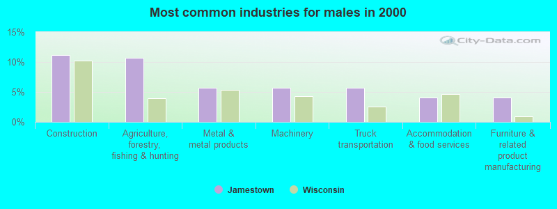
- Construction (11.1%)
- Agriculture, forestry, fishing & hunting (10.7%)
- Metal & metal products (5.7%)
- Machinery (5.7%)
- Truck transportation (5.7%)
- Accommodation & food services (4.1%)
- Furniture & related product manufacturing (4.1%)
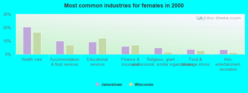
- Health care (20.4%)
- Accommodation & food services (9.9%)
- Educational services (9.4%)
- Finance & insurance (5.9%)
- Religious, grantmaking, civic, professional, similar organizations (4.9%)
- Food & beverage stores (3.8%)
- Arts, entertainment, recreation (3.4%)
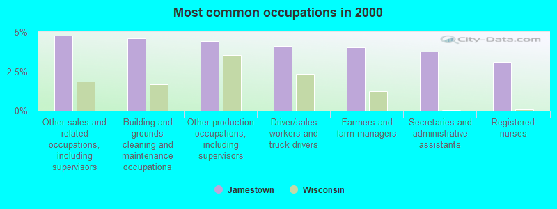
- Other sales and related occupations, including supervisors (4.8%)
- Building and grounds cleaning and maintenance occupations (4.6%)
- Other production occupations, including supervisors (4.4%)
- Driver/sales workers and truck drivers (4.1%)
- Farmers and farm managers (4.0%)
- Secretaries and administrative assistants (3.8%)
- Registered nurses (3.1%)
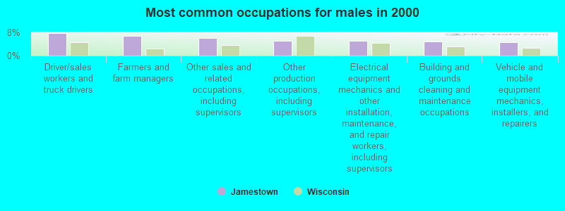
- Driver/sales workers and truck drivers (7.7%)
- Farmers and farm managers (6.8%)
- Other sales and related occupations, including supervisors (6.0%)
- Other production occupations, including supervisors (5.2%)
- Electrical equipment mechanics and other installation, maintenance, and repair workers, including supervisors (5.0%)
- Building and grounds cleaning and maintenance occupations (4.9%)
- Vehicle and mobile equipment mechanics, installers, and repairers (4.7%)

- Secretaries and administrative assistants (7.9%)
- Registered nurses (6.7%)
- Cashiers (5.9%)
- Other office and administrative support workers, including supervisors (5.9%)
- Bookkeeping, accounting, and auditing clerks (5.0%)
- Building and grounds cleaning and maintenance occupations (4.3%)
- Waiters and waitresses (4.0%)
Average climate in Jamestown, Wisconsin
Based on data reported by over 4,000 weather stations


(lower is better)
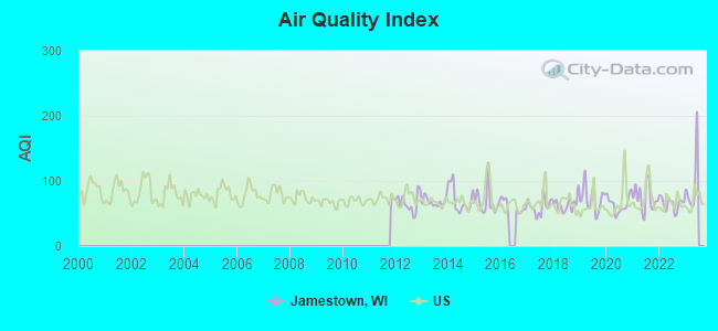
Air Quality Index (AQI) level in 2022 was 65.2. This is about average.
| City: | 65.2 |
| U.S.: | 72.6 |
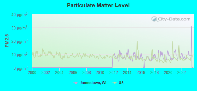
Particulate Matter (PM2.5) [µg/m3] level in 2022 was 8.17. This is about average. Closest monitor was 10.3 miles away from the city center.
| City: | 8.17 |
| U.S.: | 8.11 |
Tornado activity:
Jamestown-area historical tornado activity is above Wisconsin state average. It is 70% greater than the overall U.S. average.
On 6/7/1984, a category F5 (max. wind speeds 261-318 mph) tornado 42.3 miles away from the Jamestown town center killed 9 people and injured 200 people and caused between $50,000 and $500,000 in damages.
On 9/9/1970, a category F3 (max. wind speeds 158-206 mph) tornado 1.4 miles away from the town center .
Earthquake activity:
Jamestown-area historical earthquake activity is significantly above Wisconsin state average. It is 82% greater than the overall U.S. average.On 4/18/2008 at 09:36:59, a magnitude 5.4 (5.1 MB, 4.8 MS, 5.4 MW, 5.2 MW, Class: Moderate, Intensity: VI - VII) earthquake occurred 318.1 miles away from the city center
On 6/28/2004 at 06:10:52, a magnitude 4.2 (4.2 MW, Depth: 6.2 mi, Class: Light, Intensity: IV - V) earthquake occurred 116.0 miles away from the city center
On 6/10/1987 at 23:48:54, a magnitude 5.1 (4.9 MB, 4.4 MS, 4.6 MS, 5.1 LG) earthquake occurred 295.4 miles away from the city center
On 4/18/2008 at 09:36:59, a magnitude 5.2 (5.2 MW, Depth: 8.9 mi) earthquake occurred 318.2 miles away from the city center
On 2/10/2010 at 09:59:35, a magnitude 3.8 (3.8 MW, Depth: 6.2 mi, Class: Light, Intensity: II - III) earthquake occurred 115.2 miles away from the city center
On 6/18/2002 at 17:37:15, a magnitude 5.0 (4.3 MB, 4.6 MW, 5.0 LG) earthquake occurred 349.7 miles away from Jamestown center
Magnitude types: regional Lg-wave magnitude (LG), body-wave magnitude (MB), surface-wave magnitude (MS), moment magnitude (MW)
Natural disasters:
The number of natural disasters in Grant County (19) is greater than the US average (15).Major Disasters (Presidential) Declared: 16
Emergencies Declared: 2
Causes of natural disasters: Floods: 15, Storms: 13, Tornadoes: 7, Winds: 3, Drought: 1, Heavy Rain: 1, Hurricane: 1, Landslide: 1, Mudslide: 1, Snowstorm: 1, Winter Storm: 1, Other: 1 (Note: some incidents may be assigned to more than one category).

Hospitals and medical centers near Jamestown:
- SUNNYCREST MANOR (Nursing Home, about 4 miles away; DUBUQUE, IA)
- STONEHILL CARE CENTER (Nursing Home, about 4 miles away; DUBUQUE, IA)
- HILLS AND DALES CHILD DEVELOPMENT CENTER (Hospital, about 5 miles away; DUBUQUE, IA)
- ST DOMINIC VILLA (Nursing Home, about 5 miles away; HAZEL GREEN, WI)
- BETHANY HOME (Nursing Home, about 5 miles away; DUBUQUE, IA)
- MERCY HOME CARE/DUBUQUE (Home Health Center, about 7 miles away; DUBUQUE, IA)
- MERCY MEDICAL CENTER-DUBUQUE Acute Care Hospitals (about 7 miles away; DUBUQUE, IA)
Colleges/universities with over 2000 students nearest to Jamestown:
- University of Wisconsin-Platteville (about 14 miles; Platteville, WI; Full-time enrollment: 7,679)
- Ashford University (about 54 miles; Clinton, IA; FT enrollment: 73,330)
- Upper Iowa University (about 64 miles; Fayette, IA; FT enrollment: 5,275)
- Edgewood College (about 69 miles; Madison, WI; FT enrollment: 2,455)
- Kaplan University-Davenport Campus (about 70 miles; Davenport, IA; FT enrollment: 60,376)
- Kirkwood Community College (about 71 miles; Cedar Rapids, IA; FT enrollment: 11,503)
- University of Wisconsin Colleges (about 71 miles; Madison, WI; FT enrollment: 10,019)
Points of interest:
Notable locations in Jamestown: Kipp Farms (A), Placke Farms (B), Pleasant View Dairy (C), Beeler Tree Farm (D), Pine Ridge Farm (E), Busy B Farm (F), Rolling Ridge Ranch (G), Jamestown Fire Department (H). Display/hide their locations on the map
Cemeteries: Sinnipee Cemetery (1), Jamestown Cemetery (2), Saint Clara Cemetery (3). Display/hide their locations on the map
Lake: O'Leary Lake (A). Display/hide its location on the map
Streams, rivers, and creeks: Hollow Branch (A), Kieler Creek (B), Fair Play Creek (C), Louisburg Creek (D), Sinnipee Creek (E). Display/hide their locations on the map
| This town: | 2.5 people |
| Wisconsin: | 2.4 people |
| This town: | 74.4% |
| Whole state: | 64.4% |
| This town: | 3.8% |
| Whole state: | 7.3% |
Likely homosexual households (counted as self-reported same-sex unmarried-partner households)
- Lesbian couples: 0.2% of all households
- Gay men: 0.4% of all households
| This town: | 2.3% |
| Whole state: | 8.7% |
| This town: | 0.1% |
| Whole state: | 3.7% |
For population 15 years and over in Jamestown:
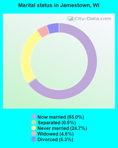
- Never married: 24.7%
- Now married: 65.0%
- Separated: 0.5%
- Widowed: 4.6%
- Divorced: 5.3%
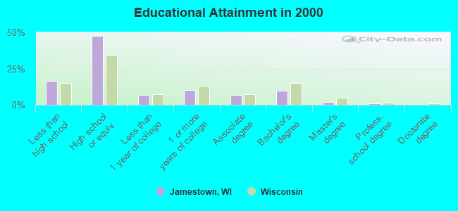
For population 25 years and over in Jamestown:
- High school or higher: 83.7%
- Bachelor's degree or higher: 12.9%
- Graduate or professional degree: 3.0%
- Unemployed: 3.0%
- Mean travel time to work (commute): 17.2 minutes
| Here: | 10.1 |
| Wisconsin average: | 11.0 |
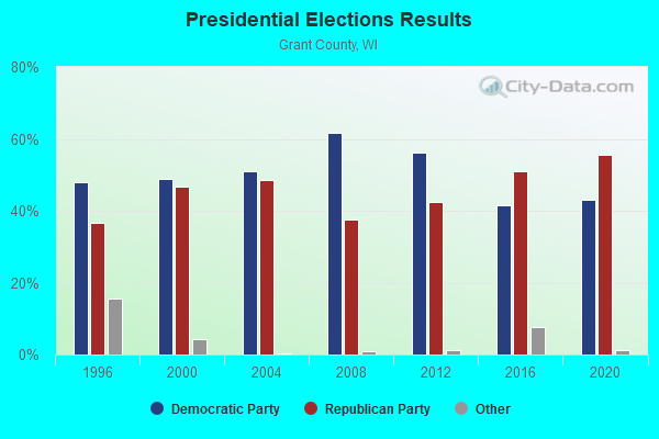
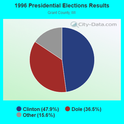
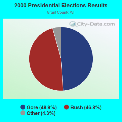
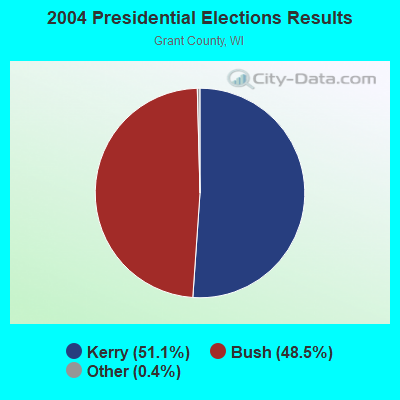
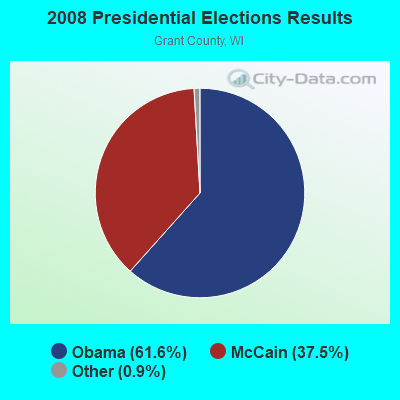
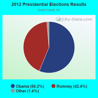
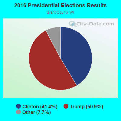
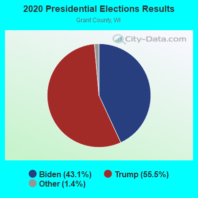
Graphs represent county-level data. Detailed 2008 Election Results
Religion statistics for Jamestown, WI (based on Grant County data)
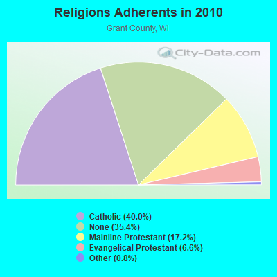
| Religion | Adherents | Congregations |
|---|---|---|
| Catholic | 20,489 | 19 |
| Mainline Protestant | 8,787 | 41 |
| Evangelical Protestant | 3,400 | 38 |
| Other | 386 | 4 |
| Orthodox | 30 | 1 |
| None | 18,116 | - |
Food Environment Statistics:
| Grant County: | 2.44 / 10,000 pop. |
| State: | 1.86 / 10,000 pop. |
| Grant County: | 5.29 / 10,000 pop. |
| Wisconsin: | 4.12 / 10,000 pop. |
| Here: | 9.97 / 10,000 pop. |
| Wisconsin: | 8.64 / 10,000 pop. |
| Grant County: | 7.7% |
| Wisconsin: | 7.6% |
| Grant County: | 27.8% |
| Wisconsin: | 27.5% |
| This county: | 11.4% |
| Wisconsin: | 13.0% |
Strongest AM radio stations in Jamestown:
- KDTH (1370 AM; 5 kW; DUBUQUE, IA; Owner: RADIO DUBUQUE, INC.)
- WDBQ (1490 AM; 1 kW; DUBUQUE, IA; Owner: CUMULUS LICENSING CORP.)
- WTMJ (620 AM; 50 kW; MILWAUKEE, WI; Owner: JOURNAL BROADCAST CORPORATION)
- KXEL (1540 AM; 50 kW; WATERLOO, IA; Owner: KXEL BROADCASTING COMPANY, INC.)
- WSCR (670 AM; 50 kW; CHICAGO, IL; Owner: INFINITY BROADCASTING OPERATIONS, INC.)
- WGN (720 AM; 50 kW; CHICAGO, IL; Owner: WGN CONTINENTAL BROADCASTING CO.)
- WBBM (780 AM; 50 kW; CHICAGO, IL; Owner: INFINITY BROADCASTING OPERATIONS, INC.)
- WPVL (1590 AM; 1 kW; PLATTEVILLE, WI; Owner: QUEENB RADIO WISCONSIN, INC.)
- WISN (1130 AM; 50 kW; MILWAUKEE, WI; Owner: CAPSTAR TX LIMITED PARTNERSHIP)
- WMVP (1000 AM; 50 kW; CHICAGO, IL; Owner: ABC, INC.)
- WSPT (1010 AM; 50 kW; STEVENS POINT, WI)
- WLS (890 AM; 50 kW; CHICAGO, IL; Owner: WLS, INC.)
- WMT (600 AM; 5 kW; CEDAR RAPIDS, IA; Owner: CITICASTERS LICENSES, L.P.)
Strongest FM radio stations in Jamestown:
- KATF (92.9 FM; DUBUQUE, IA; Owner: RADIO DUBUQUE, INC.)
- KXGE (102.3 FM; DUBUQUE, IA; Owner: CUMULUS LICENSING CORP.)
- WVRE (101.1 FM; DICKEYVILLE, WI; Owner: RADIO DUBUQUE, INC.)
- K254AE (98.7 FM; DUBUQUE, IA; Owner: UNIVERSITY OF NORTHERN IOWA)
- K269EK (101.7 FM; DUBUQUE, IA; Owner: THE UNIVERSITY OF IOWA)
- KLYV (105.3 FM; DUBUQUE, IA; Owner: CUMULUS LICENSING CORP.)
- WJOD (103.3 FM; ASBURY, IA; Owner: CUMULUS LICENSING CORP.)
- KIYX (106.1 FM; SAGEVILLE, IA; Owner: QUEENB RADIO WISCONSIN, INC.)
- WPVL-FM (107.1 FM; PLATTEVILLE, WI; Owner: QUEENB RADIO WISCONSIN, INC.)
- K239AB (95.7 FM; DUBUQUE, IA; Owner: AUGUSTANA COLLEGE)
- KGRR (97.3 FM; EPWORTH, IA; Owner: RADIO DUBUQUE, INC.)
- WGLR-FM (97.7 FM; LANCASTER, WI; Owner: QUEENB RADIO WISCONSIN, INC.)
- WDBQ-FM (107.5 FM; GALENA, IL; Owner: CUMULUS LICENSING CORP.)
- WJTY (88.1 FM; LANCASTER, WI; Owner: JOY PUBLIC BROADCASTING CORP.)
- WSUP (90.5 FM; PLATTEVILLE, WI; Owner: BOARD OF REGENTS, UNIVERSITY OF WISCONSIN SYSTEM)
TV broadcast stations around Jamestown:
- KFXB (Channel 40; DUBUQUE, IA; Owner: DUBUQUE TV LTD. PARTNERSHIP)
- W22CI (Channel 22; BLOOMINGTON, WI; Owner: STATE OF WISCONSIN - EDUCATIONAL COMMUNICATIONS BOARD)
- National Bridge Inventory (NBI) Statistics
- 38Number of bridges
- 571ft / 174mTotal length
- $17,242,000Total costs
- 122,797Total average daily traffic
- 5,899Total average daily truck traffic
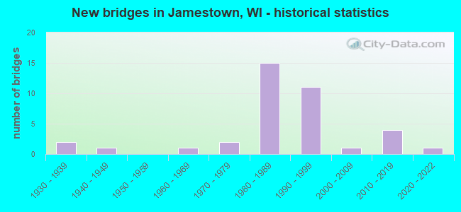
- New bridges - historical statistics
- 21930-1939
- 11940-1949
- 11960-1969
- 21970-1979
- 151980-1989
- 111990-1999
- 12000-2009
- 42010-2019
- 12020-2022
FCC Registered Antenna Towers:
4- B. Benjamin Evans, 1.4 Mi N Of Wi-Il State Line On Flamingo Road (Lat: 42.528778 Lon: -90.616250), Type: 298.1, Overall height: 297.2 m, Registrant: Evans Associates, Ben@evansassoc.Com, , Thien-sville, Phone: (262) 242-6000
- B. Benjamin Evans, 1.4 Mi N Of Wi-Il State Line On Flamingo Road (Lat: 42.528778 Lon: -90.616250), Type: 298.1, Overall height: 297.2 m, Registrant: Evans Associates, Ben@evansassoc.Com, , Thien-sville, Phone: (262) 242-6000
- B. Benjamin Evans, 1.4 Mi N Of Wi-Il State Line On Flamingo Road (Lat: 42.528778 Lon: -90.616250), Type: 298.1, Structure height: 55043 m, Overall height: 297.2 m, Registrant: Evans Engineering Solutions, Ben@evansengsolutions.Com, , Thien-sville, Phone: (262) 518-0002
- B. BENJAMIN EVANS, 1.4 Mi N Of Wi-Il State Line On Flamingo Road (Lat: 42.528778 Lon: -90.616250), Type: 298.1, Structure height: 55043 m, Overall height: 297.2 m, Registrant: Evans Engineering Solutions, Ben@evansengsolutions.Com, , Thien-sville, Phone: (262) 518-0002
FCC Registered Private Land Mobile Towers:
1- 6 Mi N Of Wisc Ill Border On Hwy 35 (Lat: 42.528611 Lon: -90.615694), Call Sign: KNDC467, Licensee ID: L00007964,
Assigned Frequencies: 861.762 MHz, 862.762 MHz, 863.762 MHz, 864.762 MHz, 865.762 MHz, Grant Date: 06/05/2002, Expiration Date: 08/21/2012, Cancellation Date: 07/15/2002, Registrant: Racom Corporation, Marshalltown, IA 50158, Phone: (515) 752-5820
FCC Registered Microwave Towers:
14 (See the full list of FCC Registered Microwave Towers in this town)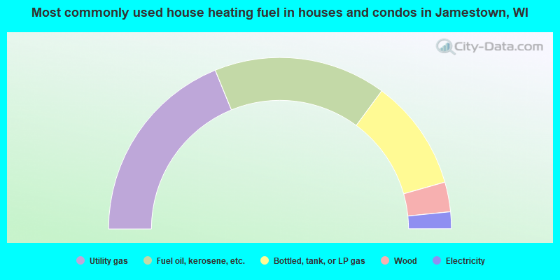
- 37.7%Utility gas
- 32.6%Fuel oil, kerosene, etc.
- 21.0%Bottled, tank, or LP gas
- 5.6%Wood
- 3.2%Electricity
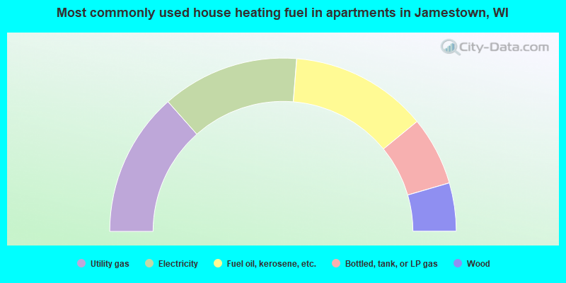
- 26.9%Utility gas
- 25.6%Electricity
- 25.6%Fuel oil, kerosene, etc.
- 12.8%Bottled, tank, or LP gas
- 9.0%Wood
Jamestown compared to Wisconsin state average:
- Unemployed percentage significantly below state average.
- Black race population percentage significantly below state average.
- Hispanic race population percentage significantly below state average.
- Foreign-born population percentage significantly below state average.
- Renting percentage significantly below state average.
- Length of stay since moving in significantly above state average.
- Number of rooms per house significantly below state average.
- House age significantly below state average.
- Percentage of population with a bachelor's degree or higher below state average.