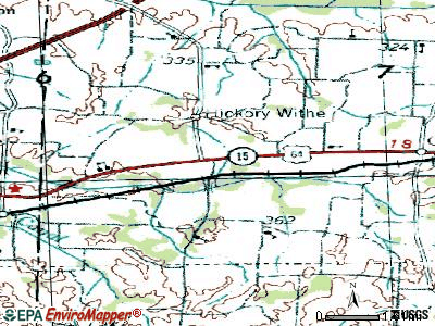
Hickory Withe, Tennessee
Submit your own pictures of this town and show them to the world
- OSM Map
- General Map
- Google Map
- MSN Map
| Males: 1,657 | |
| Females: 1,635 |
| Median resident age: | 42.6 years |
| Tennessee median age: | 35.9 years |
Zip codes: 38028.
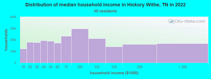
| Hickory Withe: | $117,513 |
| TN: | $65,254 |
Estimated per capita income in 2022: $60,694 (it was $26,368 in 2000)
Hickory Withe town income, earnings, and wages data
Estimated median house or condo value in 2022: $675,263 (it was $188,500 in 2000)
| Hickory Withe: | $675,263 |
| TN: | $284,800 |
Mean prices in 2022: all housing units: $371,532; detached houses: $392,642; townhouses or other attached units: $490,223; mobile homes: $101,378
Detailed information about poverty and poor residents in Hickory Withe, TN


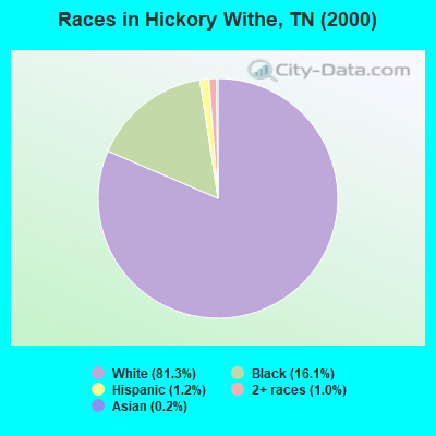
- 2,09381.3%White alone
- 41416.1%Black alone
- 321.2%Hispanic
- 271.0%Two or more races
- 50.2%Asian alone
- 20.08%American Indian alone
- 10.04%Native Hawaiian and Other
Pacific Islander alone
Races in Hickory Withe detailed stats: ancestries, foreign born residents, place of birth
 Recent articles from our blog. Our writers, many of them Ph.D. graduates or candidates, create easy-to-read articles on a wide variety of topics.

 | Question about 385/I-269 exits in Fayette County and eastern Shelby (6 replies) |
| How is Somerville,tn? (42 replies) |
| Is the Memphis area a good Real Estate Buy? (24 replies) |
| Fayette County (6 replies) |
Latest news from Hickory Withe, TN collected exclusively by city-data.com from local newspapers, TV, and radio stations
Ancestries: United States (14.8%), English (13.4%), Irish (9.9%), German (8.0%), Scotch-Irish (2.5%), Scottish (1.9%).
Current Local Time: CST time zone
Elevation: 423 feet
Land area: 28.3 square miles.
Population density: 116 people per square mile (very low).
29 residents are foreign born
| This town: | 1.1% |
| Tennessee: | 2.8% |
| Hickory Withe town: | 0.5% ($907) |
| Tennessee: | 0.8% ($715) |
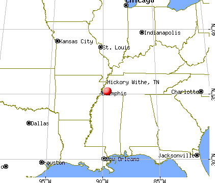
Nearest city with pop. 50,000+: Memphis, TN  (23.2 miles , pop. 650,100).
Nearest city with pop. 1,000,000+: Dallas, TX (445.7 miles , pop. 1,188,580).
Nearest cities:
), ), ), ), ), ), )Latitude: 35.22 N, Longitude: 89.58 W
Area code commonly used in this area: 901

Hickory Withe, Tennessee waste management - Economy and Business Data
| Here: | 3.8% |
| Tennessee: | 3.0% |
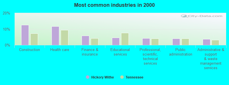
- Construction (12.5%)
- Health care (11.6%)
- Finance & insurance (5.9%)
- Educational services (4.7%)
- Professional, scientific, technical services (4.3%)
- Public administration (4.0%)
- Administrative & support & waste management services (3.8%)
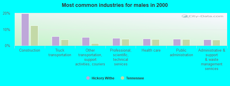
- Construction (19.8%)
- Truck transportation (5.7%)
- Other transportation, support activities, couriers (5.2%)
- Professional, scientific, technical services (4.6%)
- Health care (4.3%)
- Public administration (4.2%)
- Administrative & support & waste management services (3.7%)
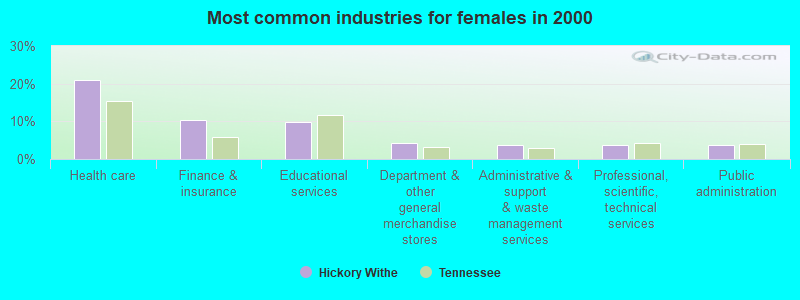
- Health care (21.0%)
- Finance & insurance (10.4%)
- Educational services (9.9%)
- Department & other general merchandise stores (4.2%)
- Administrative & support & waste management services (3.8%)
- Professional, scientific, technical services (3.8%)
- Public administration (3.8%)
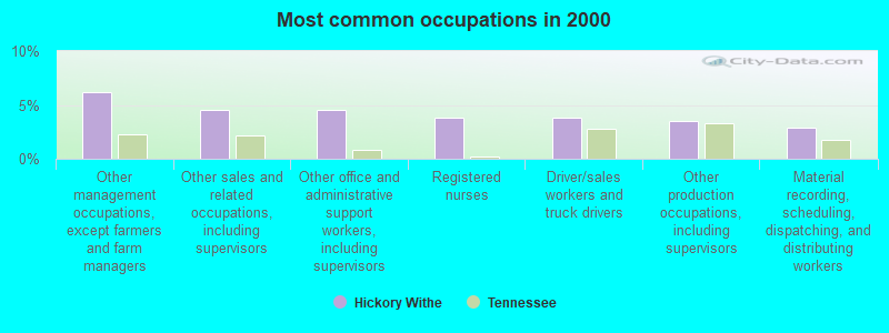
- Other management occupations, except farmers and farm managers (6.2%)
- Other sales and related occupations, including supervisors (4.6%)
- Other office and administrative support workers, including supervisors (4.5%)
- Registered nurses (3.8%)
- Driver/sales workers and truck drivers (3.8%)
- Other production occupations, including supervisors (3.5%)
- Material recording, scheduling, dispatching, and distributing workers (2.9%)
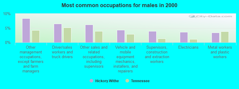
- Other management occupations, except farmers and farm managers (8.3%)
- Driver/sales workers and truck drivers (6.4%)
- Other sales and related occupations, including supervisors (6.2%)
- Vehicle and mobile equipment mechanics, installers, and repairers (4.3%)
- Supervisors, construction and extraction workers (3.9%)
- Electricians (3.6%)
- Metal workers and plastic workers (3.4%)
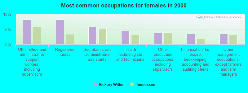
- Other office and administrative support workers, including supervisors (8.2%)
- Registered nurses (8.2%)
- Secretaries and administrative assistants (5.9%)
- Health technologists and technicians (4.4%)
- Other production occupations, including supervisors (3.8%)
- Financial clerks, except bookkeeping, accounting and auditing clerks (3.5%)
- Other management occupations, except farmers and farm managers (3.5%)
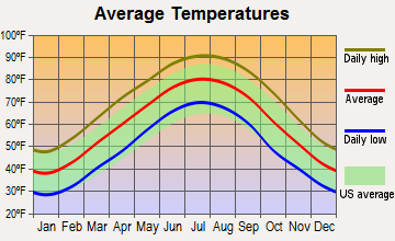
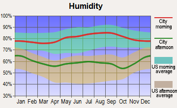
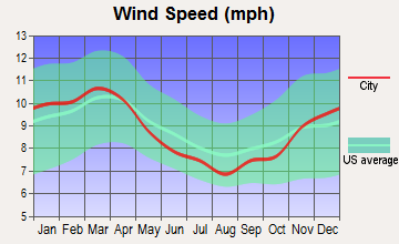
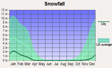
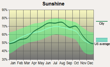
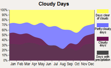
Average climate in Hickory Withe, Tennessee
Based on data reported by over 4,000 weather stations
(lower is better)
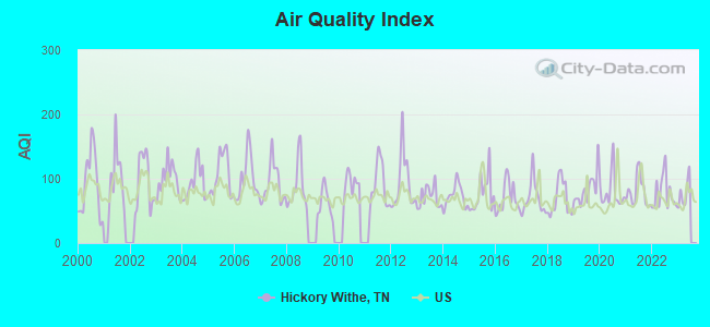
Air Quality Index (AQI) level in 2022 was 77.6. This is about average.
| City: | 77.6 |
| U.S.: | 72.6 |
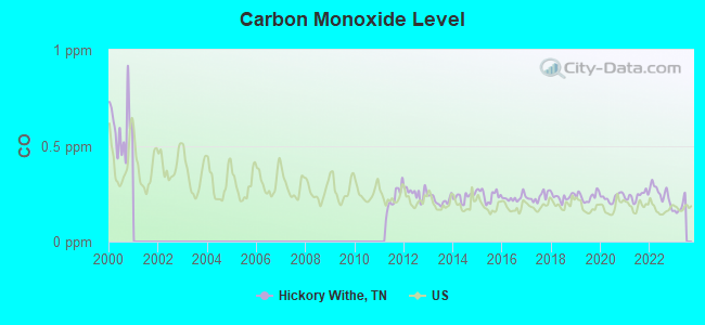
Carbon Monoxide (CO) [ppm] level in 2022 was 0.249. This is about average. Closest monitor was 16.0 miles away from the city center.
| City: | 0.249 |
| U.S.: | 0.251 |
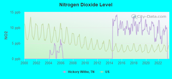
Nitrogen Dioxide (NO2) [ppb] level in 2022 was 8.49. This is significantly worse than average. Closest monitor was 4.2 miles away from the city center.
| City: | 8.49 |
| U.S.: | 5.11 |
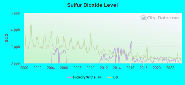
Sulfur Dioxide (SO2) [ppb] level in 2022 was 0.365. This is significantly better than average. Closest monitor was 4.2 miles away from the city center.
| City: | 0.365 |
| U.S.: | 1.515 |
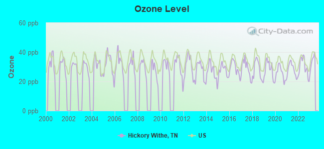
Ozone [ppb] level in 2022 was 29.9. This is about average. Closest monitor was 4.2 miles away from the city center.
| City: | 29.9 |
| U.S.: | 33.3 |
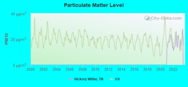
Particulate Matter (PM10) [µg/m3] level in 2022 was 16.6. This is about average. Closest monitor was 16.0 miles away from the city center.
| City: | 16.6 |
| U.S.: | 19.2 |
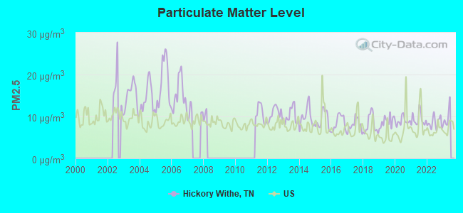
Particulate Matter (PM2.5) [µg/m3] level in 2022 was 8.53. This is about average. Closest monitor was 16.0 miles away from the city center.
| City: | 8.53 |
| U.S.: | 8.11 |
Tornado activity:
Hickory Withe-area historical tornado activity is slightly above Tennessee state average. It is 100% greater than the overall U.S. average.
On 3/21/1952, a category F4 (max. wind speeds 207-260 mph) tornado 18.5 miles away from the Hickory Withe town center killed 16 people and injured 74 people and caused between $50,000 and $500,000 in damages.
On 11/27/1994, a category F3 (max. wind speeds 158-206 mph) tornado 7.7 miles away from the town center killed 3 people and injured 25 people and caused between $5,000,000 and $50,000,000 in damages.
Earthquake activity:
Hickory Withe-area historical earthquake activity is significantly above Tennessee state average. It is 358% greater than the overall U.S. average.On 3/25/1976 at 00:41:20, a magnitude 5.0 (4.9 MB, 5.0 LG, Class: Moderate, Intensity: VI - VII) earthquake occurred 50.8 miles away from Hickory Withe center
On 5/4/1991 at 01:18:54, a magnitude 5.0 (4.4 MB, 4.6 LG, 5.0 LG, Depth: 3.1 mi) earthquake occurred 93.7 miles away from the city center
On 4/27/1989 at 16:47:49, a magnitude 4.7 (4.6 MB, 4.7 LG, 4.3 LG, Class: Light, Intensity: IV - V) earthquake occurred 55.1 miles away from the city center
On 9/26/1990 at 13:18:51, a magnitude 5.0 (4.7 MB, 4.8 LG, 5.0 LG, Depth: 7.7 mi) earthquake occurred 134.4 miles away from Hickory Withe center
On 3/25/1976 at 01:00:11, a magnitude 4.5 (4.1 MB, 4.5 LG) earthquake occurred 57.2 miles away from the city center
On 4/18/2008 at 09:36:59, a magnitude 5.4 (5.1 MB, 4.8 MS, 5.4 MW, 5.2 MW) earthquake occurred 242.2 miles away from Hickory Withe center
Magnitude types: regional Lg-wave magnitude (LG), body-wave magnitude (MB), surface-wave magnitude (MS), moment magnitude (MW)
Natural disasters:
The number of natural disasters in Fayette County (13) is near the US average (15).Major Disasters (Presidential) Declared: 10
Emergencies Declared: 1
Causes of natural disasters: Storms: 9, Tornadoes: 7, Winds: 7, Floods: 6, Winter Storms: 2, Flash Flood: 1, Heavy Rain: 1, Hurricane: 1, Ice Storm: 1, Other: 1 (Note: some incidents may be assigned to more than one category).
Hospitals and medical centers near Hickory Withe:
- WHERE THE HEART IS INC (Home Health Center, about 4 miles away; EADS, TN)
- ARLINGTON DEVELOPMENTAL CENTER (Hospital, about 7 miles away; ARLINGTON, TN)
- GALLAWAY HEALTH AND REHAB (Nursing Home, about 8 miles away; GALLAWAY, TN)
- LAYTON W WATSON NH (Nursing Home, about 8 miles away; GALLAWAY, TN)
- LAKESIDE BEHAVIORAL HEALTH SYSTEM (Hospital, about 11 miles away; MEMPHIS, TN)
- DSI GALLERIA (Dialysis Facility, about 12 miles away; MEMPHIS, TN)
- FMC BARTLETT (Dialysis Facility, about 12 miles away; BARTLETT, TN)
Colleges/universities with over 2000 students nearest to Hickory Withe:
- Rhodes College (about 24 miles; Memphis, TN; Full-time enrollment: 2,052)
- University of Memphis (about 24 miles; Memphis, TN; FT enrollment: 17,427)
- Southwest Tennessee Community College (about 27 miles; Memphis, TN; FT enrollment: 8,043)
- Northwest Mississippi Community College (about 48 miles; Senatobia, MS; FT enrollment: 6,607)
- Union University (about 52 miles; Jackson, TN; FT enrollment: 4,051)
- Jackson State Community College (about 54 miles; Jackson, TN; FT enrollment: 2,958)
- Dyersburg State Community College (about 58 miles; Dyersburg, TN; FT enrollment: 2,211)
Public elementary/middle schools in Hickory Withe:
- DUPONT HADLEY MIDDLE (Students: 642, Location: 1901 OLD HICKORY BL, Grades: 5-8)
- ANDREW JACKSON ELEMENTARY (Students: 583, Location: 110 SHUTE LA, Grades: PK-4)
- DUPONT ELEMENTARY (Students: 413, Location: 1311 9TH ST, Grades: PK-4)
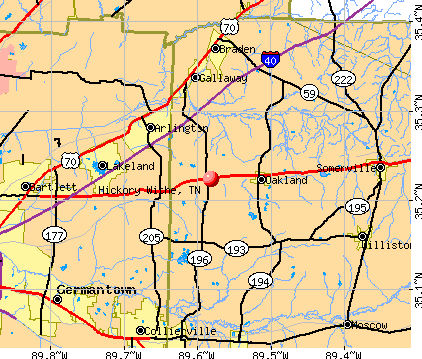
Points of interest:
Notable location: Hickory Withe Station (A). Display/hide its location on the map
Churches in Hickory Withe include: Hickory Withe First Baptist Church (A), New Prospect Church (B), Morning View Church (C). Display/hide their locations on the map
Cemeteries: Waymond Cemetery (1), Bailey Cemetery (2), Braswell Cemetery (3), McCulley Cemetery (4), Mount Pleasant Cemetery (5), Cross Cemetery (6), Dudney Cemetery (7). Display/hide their locations on the map
Reservoirs: Hall Lake (A), Salmon Lake (B), Big Bell Estates Lake (C), Greshams Lake (D). Display/hide their locations on the map
Streams, rivers, and creeks: Weber Branch (A). Display/hide its location on the map
| This town: | 2.6 people |
| Tennessee: | 2.5 people |
| This town: | 82.0% |
| Whole state: | 69.8% |
| This town: | 3.4% |
| Whole state: | 4.2% |
Likely homosexual households (counted as self-reported same-sex unmarried-partner households)
- Lesbian couples: 0.1% of all households
- Gay men: 0.2% of all households
| This town: | 4.2% |
| Whole state: | 13.5% |
| This town: | 1.2% |
| Whole state: | 5.8% |
For population 15 years and over in Hickory Withe:
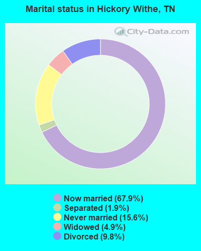
- Never married: 15.6%
- Now married: 67.9%
- Separated: 1.9%
- Widowed: 4.9%
- Divorced: 9.8%
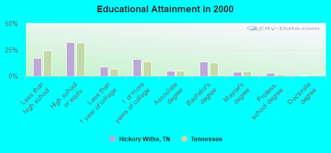
For population 25 years and over in Hickory Withe:
- High school or higher: 82.9%
- Bachelor's degree or higher: 21.0%
- Graduate or professional degree: 7.3%
- Unemployed: 4.4%
- Mean travel time to work (commute): 35.8 minutes
| Here: | 11.7 |
| Tennessee average: | 13.3 |
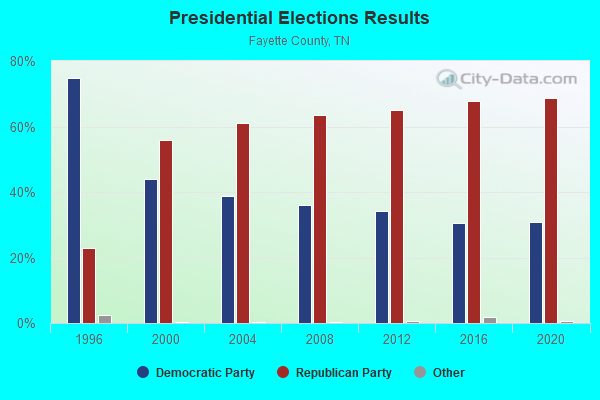
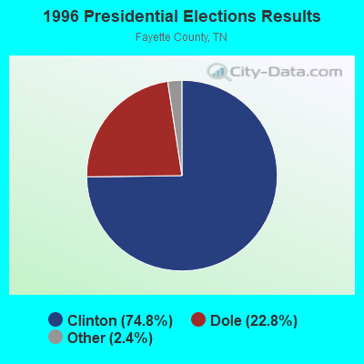
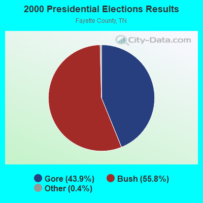


Graphs represent county-level data. Detailed 2008 Election Results
Religion statistics for Hickory Withe, TN (based on Fayette County data)
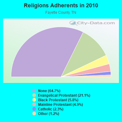
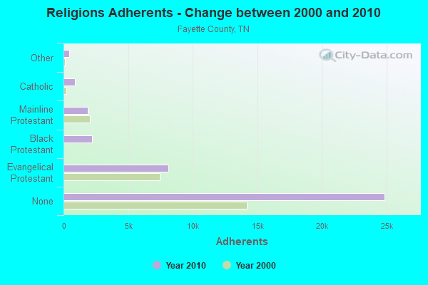
| Religion | Adherents | Congregations |
|---|---|---|
| Evangelical Protestant | 8,093 | 40 |
| Black Protestant | 2,221 | 17 |
| Mainline Protestant | 1,882 | 20 |
| Catholic | 900 | 1 |
| Other | 458 | 2 |
| None | 24,859 | - |
Food Environment Statistics:
| This county: | 1.08 / 10,000 pop. |
| State: | 1.99 / 10,000 pop. |
| Fayette County: | 0.81 / 10,000 pop. |
| Tennessee: | 0.65 / 10,000 pop. |
| Fayette County: | 4.31 / 10,000 pop. |
| Tennessee: | 5.16 / 10,000 pop. |
| This county: | 5.12 / 10,000 pop. |
| Tennessee: | 6.56 / 10,000 pop. |
| Fayette County: | 11.1% |
| State: | 11.4% |
| Fayette County: | 33.8% |
| Tennessee: | 30.2% |
| This county: | 12.5% |
| Tennessee: | 13.5% |
Strongest AM radio stations in Hickory Withe:
- WMQM (1600 AM; 50 kW; LAKELAND, TN; Owner: WMQM, INC.)
- WCRV (640 AM; 50 kW; COLLIERVILLE, TN; Owner: BOTT BROADCASTING COMPANY/TENNESSEE)
- WGSF (1030 AM; 50 kW; MEMPHIS, TN; Owner: FLINN BROADCASTING CORPORATION)
- WDIA (1070 AM; 50 kW; MEMPHIS, TN; Owner: CLEAR CHANNEL BROADCASTING LICENSES, INC.)
- WJCE (680 AM; 10 kW; MEMPHIS, TN; Owner: ENTERCOM MEMPHIS LICENSE, LLC)
- WMC (790 AM; 5 kW; MEMPHIS, TN; Owner: INFINITY RADIO OPERATIONS INC.)
- WPLX (1170 AM; 10 kW; GERMANTOWN, TN; Owner: EDUCATIONAL MEDIA FOUNDATION)
- KWAM (990 AM; 10 kW; MEMPHIS, TN; Owner: CONCORD MEDIA GROUP, INC.)
- WREC (600 AM; 5 kW; MEMPHIS, TN; Owner: CLEAR CHANNEL BROADCASTING LICENSES, INC.)
- WHBQ (560 AM; 5 kW; MEMPHIS, TN; Owner: FLINN BROADCASTING CORPORATION)
- WCPC (940 AM; 50 kW; HOUSTON, MS; Owner: WCPC BROADCASTING CO., INC.)
- WOWW (1430 AM; 2 kW; GERMANTOWN, TN; Owner: FLINN BROADCASTING CORPORATION)
- WLRM (1380 AM; 2 kW; MILLINGTON, TN; Owner: WORLD OVERCOMERS OUTREACH MINISTRIES)
Strongest FM radio stations in Hickory Withe:
- WEGR (102.7 FM; MEMPHIS, TN; Owner: CLEAR CHANNEL BROADCASTING LICENSES, INC.)
- WSRR-FM (98.1 FM; MILLINGTON, TN; Owner: KOOL BROADCASTING, INC.)
- WGKX (105.9 FM; MEMPHIS, TN; Owner: KIX BROADCASTING, INC.)
- WRVR-FM (104.5 FM; MEMPHIS, TN; Owner: ENTERCOM MEMPHIS LICENSE, LLC)
- WMPS (107.5 FM; GERMANTOWN, TN; Owner: FLINN BROADCASTING CORPORATION)
- WMC-FM (99.7 FM; MEMPHIS, TN; Owner: INFINITY RADIO OPERATIONS INC.)
- WKNO-FM (91.1 FM; MEMPHIS, TN; Owner: MID-SOUTH PUBLIC COMMUNICATIONS FOUNDATION)
- WQOX (88.5 FM; MEMPHIS, TN; Owner: MEMPHIS CITY SCHOOLS)
- WEVL (89.9 FM; MEMPHIS, TN; Owner: SOUTHERN COMMUNICATION VOLUNTEERS, INC.)
- WYPL (89.3 FM; MEMPHIS, TN; Owner: MEMPHIS/SHELBY COUNTY PUBLIC LIBRARY & INFO CNTR.)
- WUMR (91.7 FM; MEMPHIS, TN; Owner: THE UNIVERSITY OF MEMPHIS)
- WMFS (92.9 FM; BARTLETT, TN; Owner: INFINITY BROADCASTING CORP. OF ILLINOIS)
- WMBZ (94.1 FM; GERMANTOWN, TN; Owner: ENTERCOM MEMPHIS LICENSE, LLC)
- WKVF (94.9 FM; BYHALIA, MS; Owner: EDUCATIONAL MEDIA FOUNDATION)
- WHRK (97.1 FM; MEMPHIS, TN; Owner: CLEAR CHANNEL BROADCASTING LICENSES, INC.)
- KJMS (101.1 FM; MEMPHIS, TN; Owner: CLEAR CHANNEL BROADCASTING LICENSES, INC.)
- KXHT (107.1 FM; MARION, AR; Owner: FLINN BROADCASTING CORPORATION)
- WHAL-FM (95.7 FM; OLIVE BRANCH, MS; Owner: CLEAR CHANNEL BROADCASTING LICENSES, INC.)
- WKBQ (93.5 FM; COVINGTON, TN; Owner: COVINGTON BROADCASTING, INC.)
TV broadcast stations around Hickory Withe:
- WMC-TV (Channel 5; MEMPHIS, TN; Owner: RAYCOM AMERICA, INC.)
- WLMT (Channel 30; MEMPHIS, TN; Owner: CLEAR CHANNEL BROADCASTING LICENSES, INC.)
- WPTY-TV (Channel 24; MEMPHIS, TN; Owner: CLEAR CHANNEL BROADCASTING LICENSES, INC.)
- WREG-TV (Channel 3; MEMPHIS, TN; Owner: NEW YORK TIMES MANAGEMENT SERVICES)
- WPXX-TV (Channel 50; MEMPHIS, TN; Owner: FLINN BROADCASTING CORPORATION)
- WKNO (Channel 10; MEMPHIS, TN; Owner: MID-SOUTH PUBLIC COMMUNICATIONS FOUNDATION)
- WHBQ-TV (Channel 13; MEMPHIS, TN; Owner: FOX TELEVISION STATIONS, INC.)
- W57CG (Channel 57; MEMPHIS, TN; Owner: GEORGE S. FLINN, JR.)
- WBUY (Channel 40; HOLLY SPRINGS, MS; Owner: TRINITY BROADCASTING NETWORK)
- W67CV (Channel 67; MEMPHIS, TN; Owner: GEORGE S. FLINN, JR.)
- WBXP-CA (Channel 44; MEMPHIS, TN; Owner: THE BOX WORLDWIDE LLC)
- WJRJ-LP (Channel 59; MEMPHIS, TN; Owner: WORD OF GOD FELLOWSHIP, INC.)
- W42BY (Channel 42; MEMPHIS, TN; Owner: THREE ANGELS BROADCASTING NETWORK, INC,)
- National Bridge Inventory (NBI) Statistics
- 14Number of bridges
- 154ft / 47.4mTotal length
- $5,748,000Total costs
- 117,246Total average daily traffic
- 16,075Total average daily truck traffic
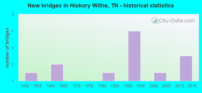
- New bridges - historical statistics
- 11950-1959
- 21960-1969
- 11980-1989
- 61990-1999
- 12000-2009
- 32010-2019
FCC Registered Microwave Towers:
2- 9ME3045S, Chulahoma Rd (Lat: 35.153944 Lon: -89.592056), Type: Ltower, Structure height: 59.1 m, Call Sign: WRZD685,
Assigned Frequencies: 21825.0 MHz, 21875.0 MHz, 21825.0 MHz, 21875.0 MHz, 21825.0 MHz, 21875.0 MHz, 21825.0 MHz, 21875.0 MHz, 21825.0 MHz, 21875.0 MHz... (+10 more), Grant Date: 10/20/2023, Expiration Date: 10/20/2033, Certifier: Jenny Knopf, Registrant: T-Mobile Usa, Inc., 12920 Se 38th Street, Bellevue, WA 98006, Phone: (425) 383-8401, Fax: (425) 383-4040, Email:
- .75 Mi Ne Of Hickory Withe (Lat: 35.252028 Lon: -89.594222), Structure height: 62.5 m, Overall height: 61 m, Call Sign: KYL56, Licensee ID: L00271084,
Assigned Frequencies: 7050.00 MHz, Grant Date: 01/19/1979, Expiration Date: 08/01/2005, Cancellation Date: 10/14/2003, Registrant: Tennessee Broadcasting Partners, 346 Muse Street, Jackson, TN 38301
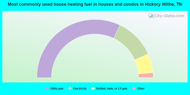
- 64.2%Utility gas
- 22.5%Electricity
- 10.7%Bottled, tank, or LP gas
- 2.5%Wood
- 0.2%Other fuel
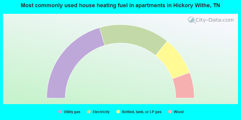
- 40.8%Utility gas
- 31.0%Electricity
- 16.9%Bottled, tank, or LP gas
- 11.3%Wood
Hickory Withe compared to Tennessee state average:
- Median household income above state average.
- Median house value significantly above state average.
- Unemployed percentage significantly below state average.
- Hispanic race population percentage significantly below state average.
- Foreign-born population percentage significantly below state average.
- Renting percentage significantly below state average.
- Length of stay since moving in significantly above state average.
- Number of rooms per house significantly below state average.
- House age significantly below state average.