Hebron, New York
Submit your own pictures of this town and show them to the world
- OSM Map
- Google Map
- MSN Map
Population change since 2000: +4.5%
 |
| Males: 945 | |
| Females: 908 |
| Median resident age: | 45.0 years |
| New York median age: | 40.7 years |
Zip codes: 12832.
| Hebron: | $67,107 |
| NY: | $79,557 |
Estimated per capita income in 2022: $34,710 (it was $18,113 in 2000)
Hebron town income, earnings, and wages data
Estimated median house or condo value in 2022: $172,004 (it was $73,500 in 2000)
| Hebron: | $172,004 |
| NY: | $400,400 |
Mean prices in 2022: all housing units: $230,821; detached houses: $233,893; townhouses or other attached units: $212,177; in 2-unit structures: $329,174; in 3-to-4-unit structures: over $1,000,000; in 5-or-more-unit structures: $895,403; mobile homes: $83,938
Detailed information about poverty and poor residents in Hebron, NY
Compare current foreclosures near Hebron, NY:
| Photo | Address | Area | Beds / Baths | Price | Details |
|---|---|---|---|---|---|

|
#1
Historic Route-7a
Manchester, VT 05254
|
1,800 sq. feet
|
2 baths 2 beds |
$329,900
|
show details |

|
#2
State Route 4
Hudson Falls, NY 12839
|
1,140 sq. feet
|
1 baths 3 beds |
$39,900
|
show details |

|
#3
Woodcrest Dr
South Glens Falls, NY 12803
|
1,504 sq. feet
|
2 baths 3 beds |
show details | |

|
#4
Orville St
Glens Falls, NY 12801
|
1,406 sq. feet
|
1 baths 2 beds |
show details | |

|
#5
Riverside Dr
Middle Granville, NY 12849
|
1,832 sq. feet
|
1 baths 3 beds |
show details | |

|
#6
Morrison Ave
Granville, NY 12832
|
3,348 sq. feet
|
2 baths 4 beds |
show details | |

|
#7
Haviland Ave
South Glens Falls, NY 12803
|
2,300 sq. feet
|
1 baths 5 beds |
show details | |

|
#8
Luzerne Pl
Queensbury, NY 12804
|
2,875 sq. feet
|
1 baths 3 beds |
show details | |

|
#9
Marlboro Country Rd
Hartford, NY 12838
|
1,824 sq. feet
|
1 baths 3 beds |
show details | |

|
#10
9th Ave
Hudson Falls, NY 12839
|
2,120 sq. feet
|
1 baths 4 beds |
show details |
| Photo | Address | Area | Beds / Baths | Price | Details |
|---|---|---|---|---|---|

|
#11
Reynolds Rd
Fort Edward, NY 12828
|
1,140 sq. feet
|
1 baths 3 beds |
show details | |

|
#12
Robertson Ave
South Glens Falls, NY 12803
|
970 sq. feet
|
1 baths 2 beds |
show details | |

|
#13
Mohican Ter
Hudson Falls, NY 12839
|
1,024 sq. feet
|
1 baths 2 beds |
show details | |

|
#14
Reservoir Rd
Fort Edward, NY 12828
|
1,974 sq. feet
|
2 baths 4 beds |
show details | |

|
#15
County Route 20
Hampton, NY 12837
|
1,364 sq. feet
|
2 baths 2 beds |
show details | |

|
#16
Big Cross St
Glens Falls, NY 12801
|
960 sq. feet
|
1 baths 2 beds |
show details | |

|
#17
Callaway Rd
Argyle, NY 12809
|
1,576 sq. feet
|
1 baths 3 beds |
show details | |

|
#18
Sanford St
Glens Falls, NY 12801
|
1,524 sq. feet
|
2 baths 4 beds |
show details | |

|
#19
Broadway
Fort Edward, NY 12828
|
2,340 sq. feet
|
2 baths 4 beds |
show details | |

|
#20
John St
Greenwich, NY 12834
|
2,636 sq. feet
|
1 baths 4 beds |
show details |
| Photo | Address | Area | Beds / Baths | Price | Details |
|---|---|---|---|---|---|

|
#21
County Route 43
Fort Ann, NY 12827
|
2,520 sq. feet
|
1 baths 1 beds |
show details | |

|
#22
Spring St
Glens Falls, NY 12801
|
909 sq. feet
|
1 baths 3 beds |
show details | |

|
#23
William St
South Glens Falls, NY 12803
|
1,116 sq. feet
|
1 baths 3 beds |
show details | |

|
#24
Walnut St
Hudson Falls, NY 12839
|
1,531 sq. feet
|
1 baths 3 beds |
show details | |

|
#25
Charles St
Glens Falls, NY 12801
|
1,629 sq. feet
|
2 baths 3 beds |
show details | |

|
#26
Bay St # 1
Glens Falls, NY 12801
|
2,471 sq. feet
|
2 baths 6 beds |
show details | |

|
#27
5th St
South Glens Falls, NY 12803
|
950 sq. feet
|
1 baths 4 beds |
show details | |

|
#28
Spring St
South Glens Falls, NY 12803
|
1,866 sq. feet
|
2 baths 4 beds |
show details | |

|
#29
Oneida St
Glens Falls, NY 12801
|
936 sq. feet
|
1 baths 3 beds |
show details | |

|
#30
Hunter St
Glens Falls, NY 12801
|
1,352 sq. feet
|
1 baths 2 beds |
show details |
| Photo | Address | Area | Beds / Baths | Price | Details |
|---|---|---|---|---|---|

|
#31
Haviland Rd
Queensbury, NY 12804
|
1,344 sq. feet
|
2 baths 3 beds |
show details | |

|
#32
2nd St
South Glens Falls, NY 12803
|
1,483 sq. feet
|
1 baths 4 beds |
show details | |

|
#33
Halsey Pl
Glens Falls, NY 12801
|
2,072 sq. feet
|
1 baths 3 beds |
show details | |

|
#34
Donna Ave
South Glens Falls, NY 12803
|
1,008 sq. feet
|
1 baths 3 beds |
show details | |

|
#35
Jenkinsville Rd
Queensbury, NY 12804
|
2,329 sq. feet
|
2 baths 3 beds |
show details | |

|
#36
Moon St
Fort Edward, NY 12828
|
1,578 sq. feet
|
1 baths 3 beds |
show details | |

|
#37
County Route 41
Hudson Falls, NY 12839
|
576 sq. feet
|
1 baths 1 beds |
show details | |

|
#38
Wilson St
Queensbury, NY 12804
|
1,066 sq. feet
|
1 baths 2 beds |
show details | |

|
#39
Preston St
Hudson Falls, NY 12839
|
1,538 sq. feet
|
1 baths 4 beds |
show details | |

|
#40
Briansky Ln
Salem, NY 12865
|
2,918 sq. feet
|
3 baths 3 beds |
show details |
| Photo | Address | Area | Beds / Baths | Price | Details |
|---|---|---|---|---|---|

|
#41
Pope Hill Rd
Granville, NY 12832
|
1,344 sq. feet
|
2 baths 3 beds |
show details | |

|
#42
East St
Hartford, NY 12838
|
788 sq. feet
|
1 baths 2 beds |
show details | |

|
#43
Feeder Dam Rd
South Glens Falls, NY 12803
|
1,056 sq. feet
|
1 baths 1 beds |
show details | |

|
#44
Williams St
Granville, NY 12832
|
1,952 sq. feet
|
1 baths 4 beds |
show details | |

|
#45
E Potter Ave
Granville, NY 12832
|
1,930 sq. feet
|
2 baths 3 beds |
show details | |

|
#46
North Rd
Queensbury, NY 12804
|
9,124 sq. feet
|
5 baths 4 beds |
show details | |

|
#47
County Route 24
Granville, NY 12832
|
2,094 sq. feet
|
2 baths 4 beds |
show details | |

|
#48
E Main St
Granville, NY 12832
|
1,914 sq. feet
|
2 baths 3 beds |
show details | |

|
#49
Thomas St
Glens Falls, NY 12801
|
1,120 sq. feet
|
1 baths 3 beds |
show details | |

|
Check over 1 million property listings on Foreclosure.com!
|
browse all offers | |||

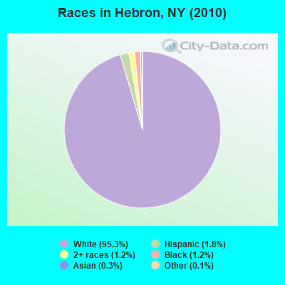
- 1,76595.3%White alone
- 341.8%Hispanic
- 221.2%Black alone
- 231.2%Two or more races
- 60.3%Asian alone
- 20.1%Other race alone
- 10.05%American Indian alone
Races in Hebron detailed stats: ancestries, foreign born residents, place of birth
According to our research of New York and other state lists, there was 1 registered sex offender living in Hebron, New York as of May 09, 2024.
The ratio of all residents to sex offenders in Hebron is 1,853 to 1.
The ratio of registered sex offenders to all residents in this city is lower than the state average.
 Recent articles from our blog. Our writers, many of them Ph.D. graduates or candidates, create easy-to-read articles on a wide variety of topics.
Ancestries: Irish (19.0%), English (17.2%), French (11.5%), German (9.7%), Italian (7.8%), United States (5.7%).
Current Local Time: EST time zone
Land area: 56.2 square miles.
Population density: 33 people per square mile (very low).
24 residents are foreign born
| This town: | 1.4% |
| New York: | 20.4% |
| Hebron town: | 1.9% ($1,386) |
| New York: | 1.9% ($2,847) |
Nearest city with pop. 50,000+: Schenectady, NY  (45.0 miles , pop. 61,821).
Nearest city with pop. 200,000+: Boston, MA (132.1 miles , pop. 589,141).
Nearest city with pop. 1,000,000+: Bronx, NY (171.1 miles , pop. 1,332,650).
Nearest cities:
), Latitude: 43.29 N, Longitude: 73.33 W
Area code commonly used in this area: 518
| Here: | 4.1% |
| New York: | 4.4% |
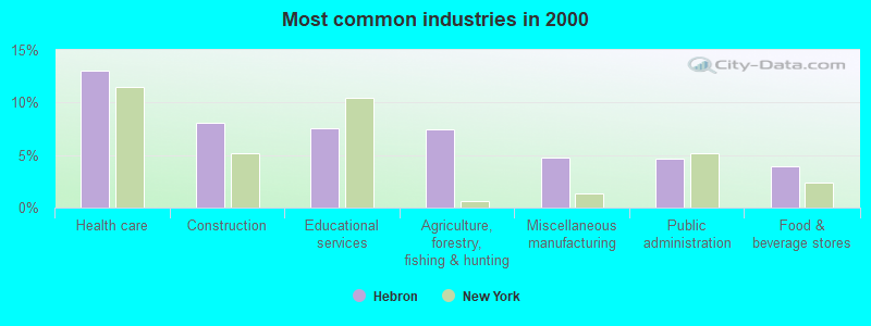
- Health care (13.1%)
- Construction (8.1%)
- Educational services (7.6%)
- Agriculture, forestry, fishing & hunting (7.5%)
- Miscellaneous manufacturing (4.8%)
- Public administration (4.7%)
- Food & beverage stores (4.0%)
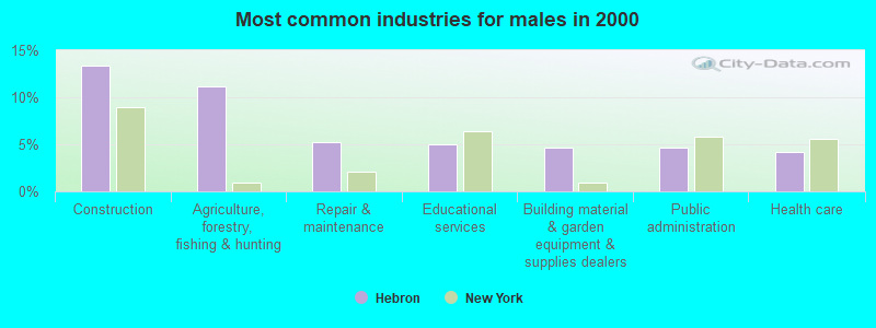
- Construction (13.3%)
- Agriculture, forestry, fishing & hunting (11.2%)
- Repair & maintenance (5.3%)
- Educational services (5.0%)
- Building material & garden equipment & supplies dealers (4.6%)
- Public administration (4.6%)
- Health care (4.2%)
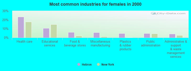
- Health care (23.3%)
- Educational services (10.5%)
- Food & beverage stores (6.0%)
- Miscellaneous manufacturing (5.8%)
- Plastics & rubber products (4.8%)
- Public administration (4.8%)
- Administrative & support & waste management services (4.3%)
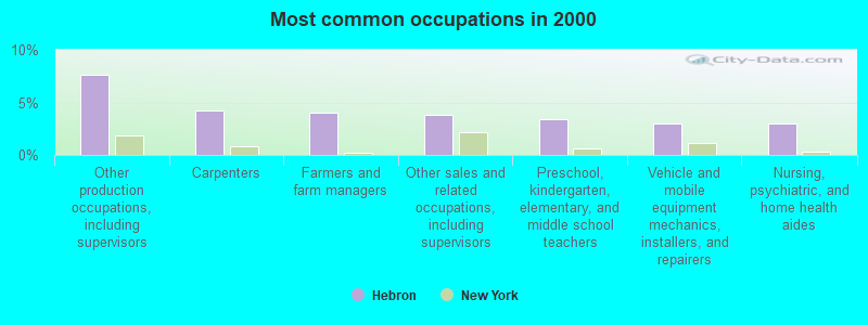
- Other production occupations, including supervisors (7.6%)
- Carpenters (4.2%)
- Farmers and farm managers (4.0%)
- Other sales and related occupations, including supervisors (3.9%)
- Preschool, kindergarten, elementary, and middle school teachers (3.4%)
- Vehicle and mobile equipment mechanics, installers, and repairers (3.0%)
- Nursing, psychiatric, and home health aides (3.0%)
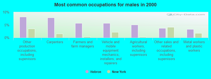
- Other production occupations, including supervisors (8.1%)
- Carpenters (7.9%)
- Farmers and farm managers (5.7%)
- Vehicle and mobile equipment mechanics, installers, and repairers (5.7%)
- Agricultural workers, including supervisors (5.0%)
- Other sales and related occupations, including supervisors (3.7%)
- Metal workers and plastic workers (3.3%)
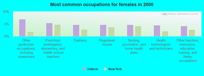
- Other production occupations, including supervisors (7.0%)
- Preschool, kindergarten, elementary, and middle school teachers (5.5%)
- Cashiers (4.8%)
- Registered nurses (4.8%)
- Nursing, psychiatric, and home health aides (4.8%)
- Health technologists and technicians (4.5%)
- Other teachers, instructors, education, training, and library occupations (4.3%)
Average climate in Hebron, New York
Based on data reported by over 4,000 weather stations


Tornado activity:
Hebron-area historical tornado activity is near New York state average. It is 61% smaller than the overall U.S. average.
On 5/31/1998, a category F3 (max. wind speeds 158-206 mph) tornado 25.9 miles away from the Hebron town center injured 68 people and caused $71 million in damages.
On 8/20/1968, a category F3 tornado 29.9 miles away from the town center injured one person and caused between $5000 and $50,000 in damages.
Earthquake activity:
Hebron-area historical earthquake activity is significantly above New York state average. It is 69% smaller than the overall U.S. average.On 10/7/1983 at 10:18:46, a magnitude 5.3 (5.1 MB, 5.3 LG, 5.1 ML, Class: Moderate, Intensity: VI - VII) earthquake occurred 68.3 miles away from Hebron center
On 4/20/2002 at 10:50:47, a magnitude 5.3 (5.3 ML, Depth: 3.0 mi) earthquake occurred 86.6 miles away from the city center
On 4/20/2002 at 10:50:47, a magnitude 5.2 (5.2 MB, 4.2 MS, 5.2 MW, 5.0 MW) earthquake occurred 85.1 miles away from the city center
On 1/19/1982 at 00:14:42, a magnitude 4.7 (4.5 MB, 4.7 MD, 4.5 LG, Class: Light, Intensity: IV - V) earthquake occurred 88.4 miles away from the city center
On 10/16/2012 at 23:12:25, a magnitude 4.7 (4.7 ML, Depth: 10.0 mi) earthquake occurred 136.2 miles away from Hebron center
On 6/17/1991 at 08:53:16, a magnitude 4.1 (4.0 MB, 4.0 LG, Depth: 3.1 mi) earthquake occurred 81.8 miles away from the city center
Magnitude types: regional Lg-wave magnitude (LG), body-wave magnitude (MB), duration magnitude (MD), local magnitude (ML), surface-wave magnitude (MS), moment magnitude (MW)
Natural disasters:
The number of natural disasters in Washington County (14) is near the US average (15).Major Disasters (Presidential) Declared: 8
Emergencies Declared: 6
Causes of natural disasters: Floods: 3, Hurricanes: 3, Storms: 3, Winter Storms: 3, Blizzard: 1, Earthquake: 1, Power Outage: 1, Other: 2 (Note: some incidents may be assigned to more than one category).
Hospitals and medical centers near Hebron:
- THE ORCHARD NURSING AND REHABILITATION CENTRE (Nursing Home, about 8 miles away; GRANVILLE, NY)
- INDIAN RIVER REHAB AND NURSING CENTER (Nursing Home, about 9 miles away; GRANVILLE, NY)
- EMMA LAING STEVENS HOSPITAL (Hospital, about 10 miles away; GRANVILLE, NY)
- WASHINGTON COUNTY PUBLIC HEALTH CHHA (Home Health Center, about 13 miles away; HUDSON FALLS, NY)
- WASHINGTON COUNTY HOSPICE AND PALLIATIVE CARE PROGRA (Hospital, about 13 miles away; HUDSON FALLS, NY)
- THE PINES AT GLENS FALLS CTR FOR NRSG AND REHAB (Nursing Home, about 16 miles away; GLENS FALLS, NY)
- AIM SERVICES, INC (Hospital, about 16 miles away; SOUTH GLENS FALLS, NY)
Amtrak stations near Hebron:
- 13 miles: FORT EDWARD/GLENS FALLS (FORT EDWARD, EAST ST.) . Services: public payphones, free short-term parking, free long-term parking, call for car rental service, call for taxi service.
- 19 miles: WHITEHALL (MAIN ST.) . Services: enclosed waiting area, public payphones, free short-term parking, free long-term parking, call for taxi service.
Colleges/universities with over 2000 students nearest to Hebron:
- Adirondack Community College (about 17 miles; Queensbury, NY; Full-time enrollment: 2,826)
- Castleton State College (about 24 miles; Castleton, VT; FT enrollment: 2,079)
- Skidmore College (about 27 miles; Saratoga Springs, NY; FT enrollment: 2,753)
- SUNY Empire State College (about 27 miles; Saratoga Springs, NY; FT enrollment: 9,473)
- Williams College (about 41 miles; Williamstown, MA; FT enrollment: 2,141)
- Rensselaer Polytechnic Institute (about 43 miles; Troy, NY; FT enrollment: 6,940)
- The Sage Colleges (about 43 miles; Troy, NY; FT enrollment: 2,499)
Points of interest:
Notable locations in Hebron: Birch Hill Farm (A), Chamberlin Mills (B). Display/hide their locations on the map
Churches in Hebron include: West Hebron Presbyterian Church (A), Hebron Church (B). Display/hide their locations on the map
Cemeteries: Braymer Cemetery (1), Glasier Cemetery (2), Smith Cemetery (3), Burch Cemetery (4), Moorehouse Cemetery (5), Parish Cemetery (6), East Hebron Cemetery (7). Display/hide their locations on the map
Lakes: Smith Pond (A), Barkley Pond (B), Green Pond (C). Display/hide their locations on the map
Creeks: Dead Creek (A), West Branch Black Creek (B). Display/hide their locations on the map
Birthplace of: Samuel Nelson - Judge, Hiram Barton - Politician.
| This town: | 2.5 people |
| New York: | 2.6 people |
| This town: | 70.3% |
| Whole state: | 63.5% |
| This town: | 9.7% |
| Whole state: | 6.8% |
Likely homosexual households (counted as self-reported same-sex unmarried-partner households)
- Lesbian couples: 0.1% of all households
- Gay men: 0.9% of all households
| This town: | 9.7% |
| Whole state: | 14.6% |
| This town: | 3.2% |
| Whole state: | 7.4% |
For population 15 years and over in Hebron:

- Never married: 22.3%
- Now married: 59.6%
- Separated: 1.3%
- Widowed: 6.8%
- Divorced: 10.0%
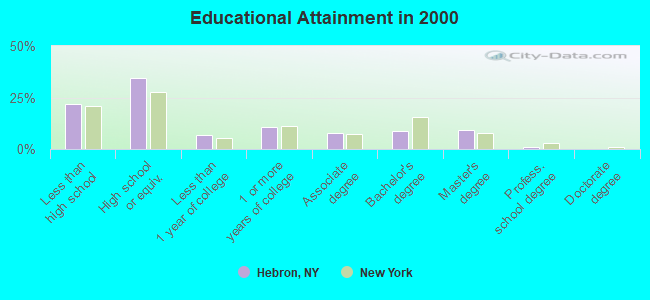
For population 25 years and over in Hebron:
- High school or higher: 78.2%
- Bachelor's degree or higher: 19.2%
- Graduate or professional degree: 10.2%
- Unemployed: 5.7%
- Mean travel time to work (commute): 30.2 minutes
| Here: | 12.7 |
| New York average: | 14.2 |
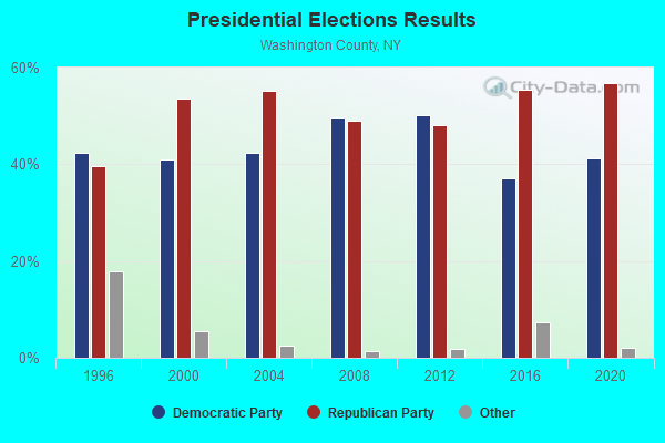
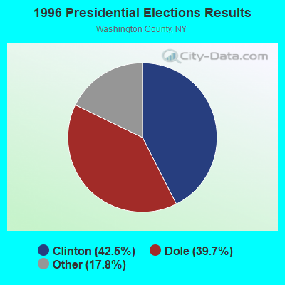
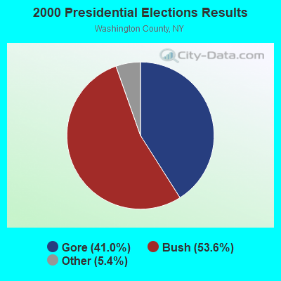
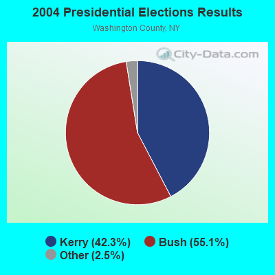
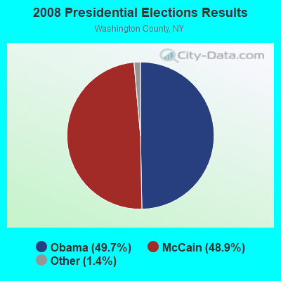

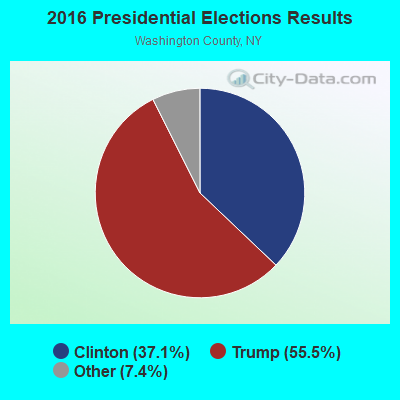
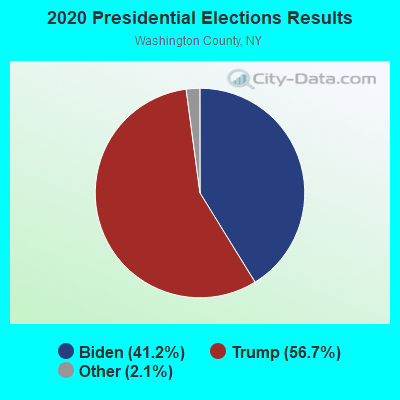
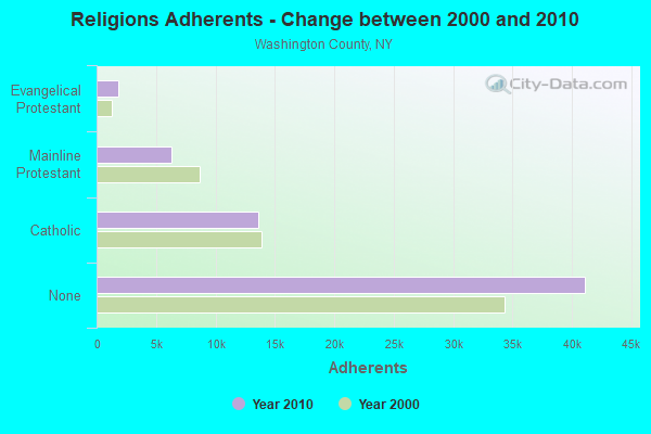
Graphs represent county-level data. Detailed 2008 Election Results
Religion statistics for Hebron, NY (based on Washington County data)
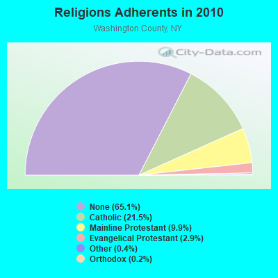
| Religion | Adherents | Congregations |
|---|---|---|
| Catholic | 13,581 | 10 |
| Mainline Protestant | 6,259 | 54 |
| Evangelical Protestant | 1,856 | 19 |
| Other | 256 | 4 |
| Orthodox | 140 | 3 |
| None | 41,124 | - |
Food Environment Statistics:
| This county: | 1.92 / 10,000 pop. |
| State: | 4.13 / 10,000 pop. |
| This county: | 4.32 / 10,000 pop. |
| New York: | 1.68 / 10,000 pop. |
| Washington County: | 7.51 / 10,000 pop. |
| New York: | 8.82 / 10,000 pop. |
| Washington County: | 8.1% |
| State: | 8.2% |
| Washington County: | 26.7% |
| New York: | 23.8% |
| This county: | 17.1% |
| State: | 15.6% |
Strongest AM radio stations in Hebron:
- WGY (810 AM; 50 kW; SCHENECTADY, NY; Owner: CLEAR CHANNEL BROADCASTING LICENSES, INC.)
- WPTR (1540 AM; 50 kW; ALBANY, NY; Owner: KIMTRON, INC.)
- WNNZ (640 AM; 50 kW; WESTFIELD, MA; Owner: CLEAR CHANNEL BROADCASTING LICENSES, INC.)
- WCRN (830 AM; 50 kW; WORCESTER, MA; Owner: CARTER BROADCASTING CORPORATION)
- WSYB (1380 AM; 5 kW; RUTLAND, VT; Owner: CAPSTAR TX LIMITED PARTNERSHIP)
- WRKO (680 AM; 50 kW; BOSTON, MA; Owner: ENTERCOM BOSTON LICENSE, LLC)
- WABY (1160 AM; 5 kW; MECHANICVILLE, NY; Owner: ANASTOS MEDIA GROUP, INC.)
- WTIC (1080 AM; 50 kW; HARTFORD, CT; Owner: INFINITY RADIO OPERATIONS INC.)
- WEEI (850 AM; 50 kW; BOSTON, MA; Owner: ENTERCOM BOSTON LICENSE, LLC)
- WVNE (760 AM; daytime; 25 kW; LEICESTER, MA; Owner: BLOUNT MASSCOM, INC.)
- WCHP (760 AM; 35 kW; CHAMPLAIN, NY; Owner: CHAMPLAIN RADIO, INC.)
- WWSC (1450 AM; 1 kW; GLENS FALLS, NY; Owner: ENTERTRONICS, INC.)
- WMML (1230 AM; 1 kW; GLENS FALLS, NY; Owner: VOX NEW YORK, L.L.C.)
Strongest FM radio stations in Hebron:
- WLJH (90.9 FM; GLENS FALLS, NY; Owner: SOUND OF LIFE INC)
- WNGN (91.9 FM; ARGYLE, NY; Owner: NORTHEAST GOSPEL BROADCASTING INC)
- WEQX (102.7 FM; MANCHESTER, VT; Owner: NORTHSHIRE COMMUNICATIONS, INC.)
- WJAN (95.1 FM; SUNDERLAND, VT; Owner: 6 JOHNSON ROAD LICENSES, INC.)
- WJJR (98.1 FM; RUTLAND, VT; Owner: 6 JOHNSON ROAD LICENSES, INC.)
- WZRT (97.1 FM; RUTLAND, VT; Owner: CAPSTAR TX LIMITED PARTNERSHIP)
- WMNV (104.1 FM; RUPERT, VT; Owner: CAPITAL MEDIA CORPORATION)
- WEBK (105.3 FM; KILLINGTON, VT; Owner: 6 JOHNSON ROAD LICENSES, INC.)
- WGLV (91.7 FM; WOODSTOCK, VT; Owner: CHRISTIAN MINISTRIES INC)
- WHDQ-FM1 (106.1 FM; RUTLAND, VT; Owner: GREAT NORTHERN RADIO, L.L.C.)
- WKBE (100.3 FM; WARRENSBURG, NY; Owner: 6 JOHNSON ROAD LICENSES, INC.)
- WCKM-FM (99.1 FM; LAKE GEORGE, NY; Owner: ENTERTRONICS, INC.)
- WNYQ (105.7 FM; QUEENSBURY, NY; Owner: VOX NEW YORK, L.L.C.)
- WVAY (100.7 FM; WILMINGTON, VT; Owner: GREAT NORTHERN RADIO, L.L.C.)
- WBAR-FM (94.7 FM; LAKE LUZERNE, NY; Owner: CAPITAL MEDIA CORPORATION)
- WCQL (95.9 FM; GLENS FALLS, NY; Owner: ENTERTRONICS, INC.)
- WFFG-FM (107.1 FM; CORINTH, NY; Owner: VOX NEW YORK, L.L.C.)
- WVPR (89.5 FM; WINDSOR, VT; Owner: VERMONT PUBLIC RADIO)
- WXLG (89.9 FM; NORTH CREEK, NY; Owner: THE ST. LAWRENCE UNIVERSITY)
- WAMC-FM (90.3 FM; ALBANY, NY; Owner: WAMC)
TV broadcast stations around Hebron:
- WNYA-CA (Channel 39; EASTON, ETC., NY; Owner: VENTURE TECHNOLOGIES GROUP, LLC)
- WNCE-CA (Channel 8; GLENS FALLS, NY; Owner: NORTHERN BROADCASTING COMPANY, INC.)
- National Bridge Inventory (NBI) Statistics
- 11Number of bridges
- 39ft / 11.9mTotal length
- $4,252,000Total costs
- 2,468Total average daily traffic
- 145Total average daily truck traffic
- 3,454Total future (year 2034) average daily traffic
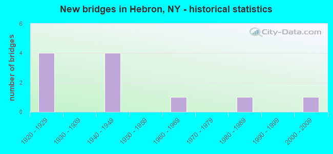
- New bridges - historical statistics
- 41920-1929
- 41940-1949
- 11960-1969
- 11980-1989
- 12000-2009
FCC Registered Cell Phone Towers:
1- 433 Mckinght Rd (Lat: 43.267194 Lon: -73.347528), Type: Ltower, Structure height: 59.4 m, Overall height: 60.7 m, Call Sign: KNKA738
Assigned Frequencies: 869.040 MHz, 869.040 MHz, 869.040 MHz, 824.040 MHz, 824.040 MHz, 824.040 MHz, 890.010 MHz, 890.010 MHz, 890.010 MHz, 845.010 MHz, 845.010 MHz, 845.010 MHzGrant Date: 08/28/2018, Expiration Date: 10/01/2028, Certifier: David C JatlowRegistrant: At&t Services, Inc., 208 S Akard St, 20f, Dallas, TX 75202, Phone: (855) 699-7073, Fax: (214) 746-6410, Email:
FCC Registered Broadcast Land Mobile Towers:
8 (See the full list of FCC Registered Broadcast Land Mobile Towers in Hebron, NY)FCC Registered Microwave Towers:
8 (See the full list of FCC Registered Microwave Towers in this town)
- 68.8%Fuel oil, kerosene, etc.
- 15.3%Wood
- 8.9%Bottled, tank, or LP gas
- 5.1%Electricity
- 1.1%Coal or coke
- 0.9%Other fuel
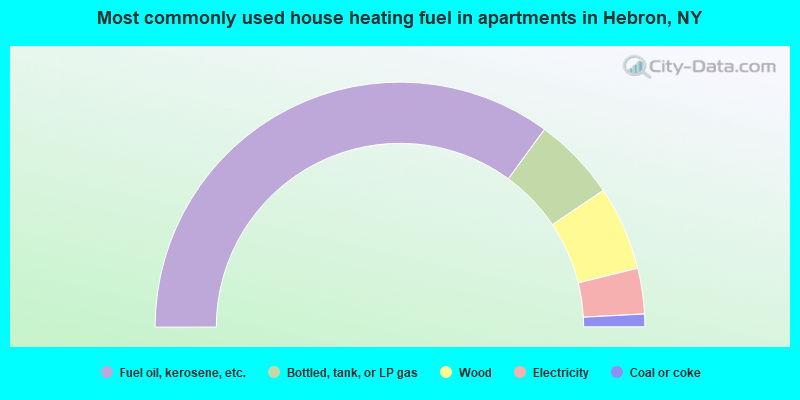
- 70.1%Fuel oil, kerosene, etc.
- 11.1%Bottled, tank, or LP gas
- 11.1%Wood
- 6.0%Electricity
- 1.7%Coal or coke
Hebron compared to New York state average:
- Median house value significantly below state average.
- Unemployed percentage below state average.
- Black race population percentage significantly below state average.
- Hispanic race population percentage significantly below state average.
- Median age above state average.
- Foreign-born population percentage significantly below state average.
- Renting percentage significantly below state average.
- Length of stay since moving in significantly above state average.
- Number of rooms per house significantly below state average.
- House age significantly below state average.
- Number of college students below state average.