Hawley, Massachusetts
Submit your own pictures of this town and show them to the world
- OSM Map
- General Map
- Google Map
- MSN Map
Population change since 2000: +0.3%
 |
| Males: 170 | |
| Females: 167 |
| Median resident age: | 48.7 years |
| Massachusetts median age: | 39.2 years |
Zip codes: 01339.
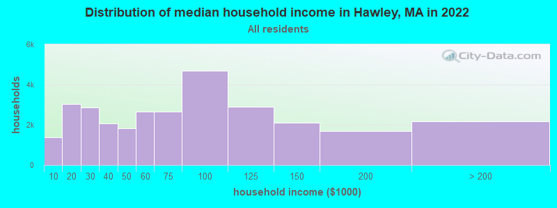
| Hawley: | $65,748 |
| MA: | $94,488 |
Estimated per capita income in 2022: $31,580 (it was $17,333 in 2000)
Hawley town income, earnings, and wages data
Estimated median house or condo value in 2022: $285,049 (it was $114,700 in 2000)
| Hawley: | $285,049 |
| MA: | $534,700 |
Mean prices in 2022: all housing units: $313,377; detached houses: $324,224; townhouses or other attached units: $284,225; in 2-unit structures: $287,978; in 3-to-4-unit structures: $183,938; in 5-or-more-unit structures: $249,762; mobile homes: $62,200
Detailed information about poverty and poor residents in Hawley, MA


- 32395.8%White alone
- 51.5%Hispanic
- 41.2%Asian alone
- 20.6%American Indian alone
- 20.6%Two or more races
- 10.3%Black alone
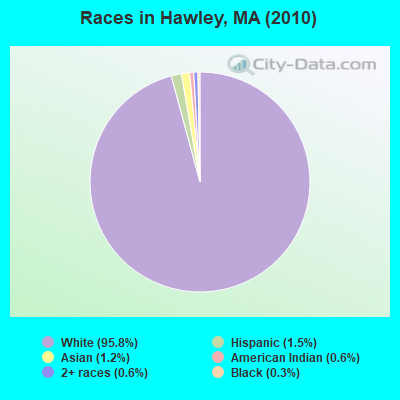
Races in Hawley detailed stats: ancestries, foreign born residents, place of birth
According to our research of Massachusetts and other state lists, there was 1 registered sex offender living in Hawley, Massachusetts as of May 22, 2024.
The ratio of all residents to sex offenders in Hawley is 337 to 1.
 Recent articles from our blog. Our writers, many of them Ph.D. graduates or candidates, create easy-to-read articles on a wide variety of topics.


Latest news from Hawley, MA collected exclusively by city-data.com from local newspapers, TV, and radio stations
Ancestries: English (20.8%), German (12.2%), Irish (12.2%), French Canadian (10.1%), French (6.0%), Dutch (4.8%).
Current Local Time: EST time zone
Incorporated in 1792
Elevation: 1752 feet
Land area: 30.9 square miles.
Population density: 11 people per square mile (very low).
5 residents are foreign born
| This town: | 1.5% |
| Massachusetts: | 12.2% |
| Hawley town: | 1.2% ($1,320) |
| Massachusetts: | 1.3% ($2,336) |
Nearest city with pop. 50,000+: Chicopee, MA  (32.7 miles , pop. 54,653).
Nearest city with pop. 200,000+: Boston, MA (94.9 miles , pop. 589,141).
Nearest city with pop. 1,000,000+: Bronx, NY (129.3 miles , pop. 1,332,650).
Nearest cities:
), ), ), ), )Latitude: 42.58 N, Longitude: 72.92 W
Area code commonly used in this area: 413

Single-family new house construction building permits:
- 2021: 1 building, cost: $672,800
- 2019: 1 building, cost: $900,000
- 2018: 2 buildings, average cost: $225,000
- 2015: 1 building, cost: $518,300
- 2014: 2 buildings, average cost: $171,400
- 2012: 1 building, cost: $130,000
- 2011: 1 building, cost: $345,200
- 2009: 2 buildings, average cost: $170,300
- 2007: 3 buildings, average cost: $139,400
- 2004: 1 building, cost: $194,200
- 2003: 2 buildings, average cost: $159,500
- 2002: 4 buildings, average cost: $99,000
- 2001: 1 building, cost: $108,400
- 2000: 2 buildings, average cost: $56,800
- 1999: 1 building, cost: $160,300
- 1997: 1 building, cost: $74,600
| Here: | 1.9% |
| Massachusetts: | 3.5% |
- Construction (14.0%)
- Health care (12.2%)
- Educational services (7.9%)
- Wood products (6.1%)
- Public administration (5.5%)
- Religious, grantmaking, civic, professional, similar organizations (4.9%)
- Agriculture, forestry, fishing & hunting (4.3%)
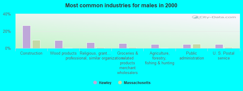
- Construction (26.4%)
- Wood products (9.2%)
- Religious, grantmaking, civic, professional, similar organizations (6.9%)
- Groceries & related products merchant wholesalers (5.7%)
- Agriculture, forestry, fishing & hunting (4.6%)
- Public administration (4.6%)
- U. S. Postal service (4.6%)
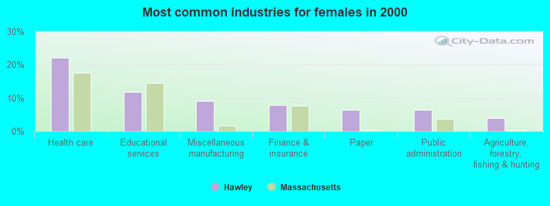
- Health care (22.1%)
- Educational services (11.7%)
- Miscellaneous manufacturing (9.1%)
- Finance & insurance (7.8%)
- Paper (6.5%)
- Public administration (6.5%)
- Agriculture, forestry, fishing & hunting (3.9%)
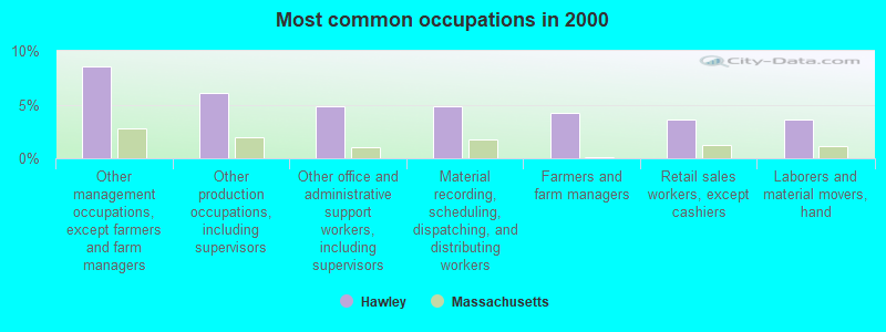
- Other management occupations, except farmers and farm managers (8.5%)
- Other production occupations, including supervisors (6.1%)
- Other office and administrative support workers, including supervisors (4.9%)
- Material recording, scheduling, dispatching, and distributing workers (4.9%)
- Farmers and farm managers (4.3%)
- Retail sales workers, except cashiers (3.7%)
- Laborers and material movers, hand (3.7%)
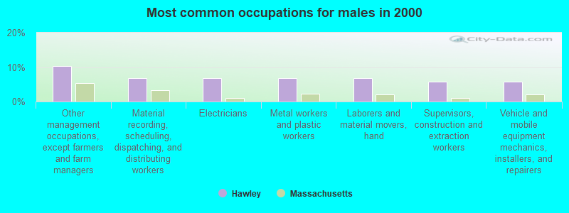
- Other management occupations, except farmers and farm managers (10.3%)
- Material recording, scheduling, dispatching, and distributing workers (6.9%)
- Electricians (6.9%)
- Metal workers and plastic workers (6.9%)
- Laborers and material movers, hand (6.9%)
- Supervisors, construction and extraction workers (5.7%)
- Vehicle and mobile equipment mechanics, installers, and repairers (5.7%)
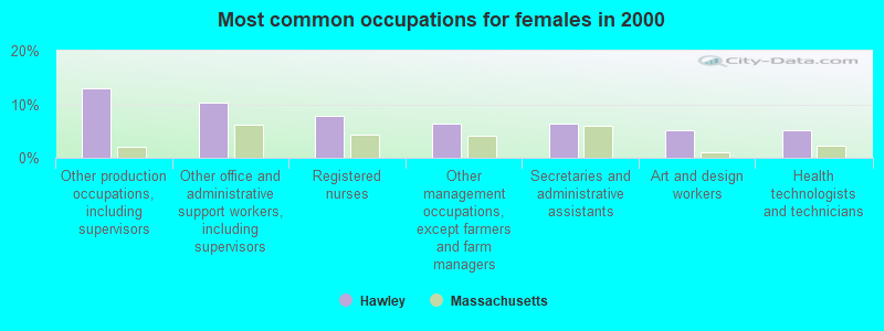
- Other production occupations, including supervisors (13.0%)
- Other office and administrative support workers, including supervisors (10.4%)
- Registered nurses (7.8%)
- Other management occupations, except farmers and farm managers (6.5%)
- Secretaries and administrative assistants (6.5%)
- Art and design workers (5.2%)
- Health technologists and technicians (5.2%)
Average climate in Hawley, Massachusetts
Based on data reported by over 4,000 weather stations


(lower is better)
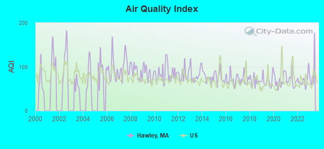
Air Quality Index (AQI) level in 2022 was 69.0. This is about average.
| City: | 69.0 |
| U.S.: | 72.6 |
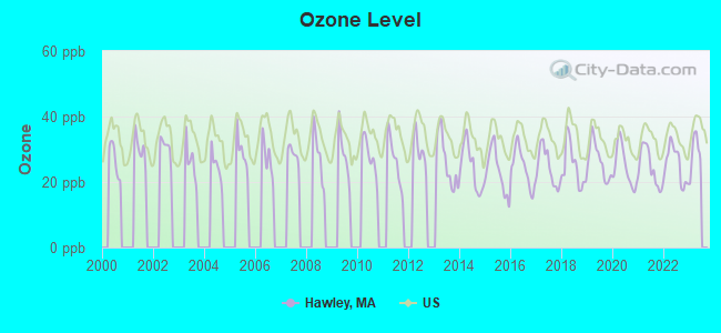
Ozone [ppb] level in 2022 was 25.4. This is better than average. Closest monitor was 16.3 miles away from the city center.
| City: | 25.4 |
| U.S.: | 33.3 |
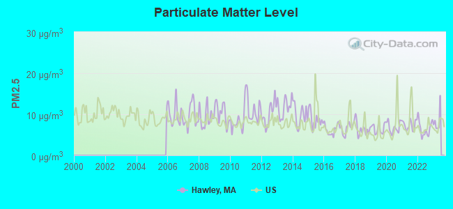
Particulate Matter (PM2.5) [µg/m3] level in 2022 was 6.49. This is better than average. Closest monitor was 13.2 miles away from the city center.
| City: | 6.49 |
| U.S.: | 8.11 |
Tornado activity:
Hawley-area historical tornado activity is slightly above Massachusetts state average. It is 17% smaller than the overall U.S. average.
On 8/28/1973, a category F4 (max. wind speeds 207-260 mph) tornado 27.8 miles away from the Hawley town center killed 4 people and injured 36 people and caused between $5,000,000 and $50,000,000 in damages.
On 5/29/1995, a category F4 tornado 30.9 miles away from the town center killed 3 people and injured 24 people and caused between $5,000,000 and $50,000,000 in damages.
Earthquake activity:
Hawley-area historical earthquake activity is significantly above Massachusetts state average. It is 69% smaller than the overall U.S. average.On 10/7/1983 at 10:18:46, a magnitude 5.3 (5.1 MB, 5.3 LG, 5.1 ML, Class: Moderate, Intensity: VI - VII) earthquake occurred 119.3 miles away from the city center
On 4/20/2002 at 10:50:47, a magnitude 5.3 (5.3 ML, Depth: 3.0 mi) earthquake occurred 139.6 miles away from the city center
On 4/20/2002 at 10:50:47, a magnitude 5.2 (5.2 MB, 4.2 MS, 5.2 MW, 5.0 MW) earthquake occurred 138.2 miles away from Hawley center
On 1/19/1982 at 00:14:42, a magnitude 4.7 (4.5 MB, 4.7 MD, 4.5 LG, Class: Light, Intensity: IV - V) earthquake occurred 92.3 miles away from Hawley center
On 10/16/2012 at 23:12:25, a magnitude 4.7 (4.7 ML, Depth: 10.0 mi) earthquake occurred 134.3 miles away from the city center
On 6/17/1991 at 08:53:16, a magnitude 4.1 (4.0 MB, 4.0 LG, Depth: 3.1 mi) earthquake occurred 89.7 miles away from Hawley center
Magnitude types: regional Lg-wave magnitude (LG), body-wave magnitude (MB), duration magnitude (MD), local magnitude (ML), surface-wave magnitude (MS), moment magnitude (MW)
Natural disasters:
The number of natural disasters in Franklin County (20) is greater than the US average (15).Major Disasters (Presidential) Declared: 9
Emergencies Declared: 10
Causes of natural disasters: Floods: 5, Storms: 5, Hurricanes: 4, Snowstorms: 4, Winter Storms: 3, Blizzards: 2, Snows: 2, Snowfall: 1, Tropical Storm: 1, Wind: 1, Other: 1 (Note: some incidents may be assigned to more than one category).

Hospitals and medical centers near Hawley:
- NORTHERN BERKSHIRE COMPREHENSIVE CARE (Home Health Center, about 12 miles away; ADAMS, MA)
- HOSPICE OF N BERKSHIRE INC (Hospital, about 12 miles away; ADAMS, MA)
- ANCHORAGE NURSING HOME (Nursing Home, about 13 miles away; SHELBURNE, MA)
- NORTH ADAMS COMMONS NURSING AND REHABILITATION CENTE (Nursing Home, about 14 miles away; NORTH ADAMS, MA)
- ADAMS N H OF N ADAMS (Nursing Home, about 14 miles away; NORTH ADAMS, MA)
- NORTH ADAMS REGIONAL HOSPITAL Acute Care Hospitals (about 14 miles away; NORTH ADAMS, MA)
- CHARLENE MANOR EXTENDED CARE FACILITY (Nursing Home, about 16 miles away; GREENFIELD, MA)
Colleges/universities with over 2000 students nearest to Hawley:
- Williams College (about 18 miles; Williamstown, MA; Full-time enrollment: 2,141)
- Smith College (about 23 miles; Northampton, MA; FT enrollment: 3,549)
- University of Massachusetts-Amherst (about 24 miles; Amherst, MA; FT enrollment: 26,583)
- Mount Holyoke College (about 29 miles; South Hadley, MA; FT enrollment: 2,573)
- Holyoke Community College (about 30 miles; Holyoke, MA; FT enrollment: 4,911)
- Westfield State University (about 32 miles; Westfield, MA; FT enrollment: 5,548)
- Springfield Technical Community College (about 37 miles; Springfield, MA; FT enrollment: 4,750)
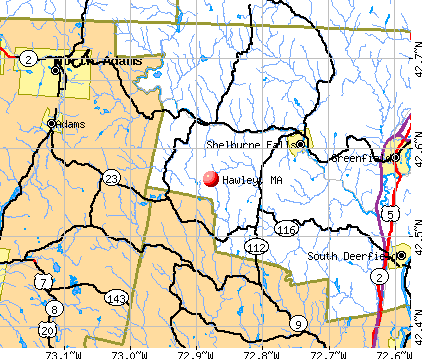
Points of interest:
Notable location: Hawley Fire Department (A). Display/hide its location on the map
Cemetery: Doane Cemetery (1). Display/hide its location on the map
Lakes, reservoirs, and swamps: Beaver Pond (A), North Pond Brook (B), Cox Pond (C), Nemasket River Reservoir (D), Cranberry Swamp (E). Display/hide their locations on the map
Streams, rivers, and creeks: Potash Brook (A), North Brook (B), Mill Brook (C), King Brook (D), Hawks Brook (E), Fuller Brook (F), Basin Brook (G). Display/hide their locations on the map
| This town: | 2.4 people |
| Massachusetts: | 2.5 people |
| This town: | 66.4% |
| Whole state: | 63.0% |
| This town: | 14.8% |
| Whole state: | 7.0% |
Likely homosexual households (counted as self-reported same-sex unmarried-partner households)
- Lesbian couples: 3.1% of all households
- Gay men: 0.0% of all households
| This town: | 14.2% |
| Whole state: | 9.3% |
| This town: | 6.9% |
| Whole state: | 4.4% |
For population 15 years and over in Hawley:
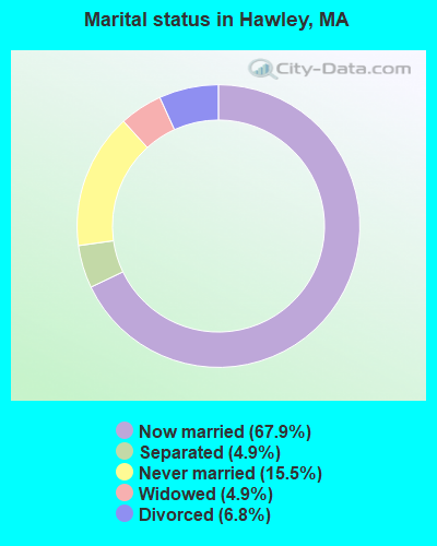
- Never married: 15.5%
- Now married: 67.9%
- Separated: 4.9%
- Widowed: 4.9%
- Divorced: 6.8%
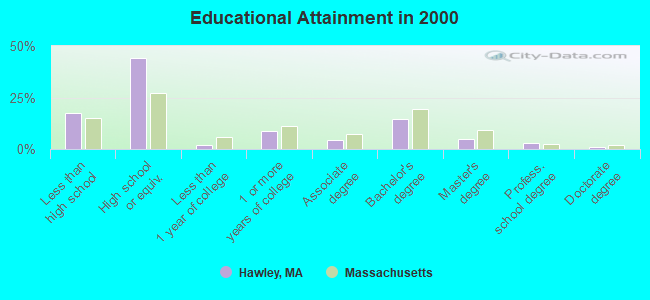
For population 25 years and over in Hawley:
- High school or higher: 82.6%
- Bachelor's degree or higher: 23.2%
- Graduate or professional degree: 8.7%
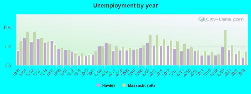
- Unemployed: 7.9%
- Mean travel time to work (commute): 37.1 minutes
| Here: | 11.2 |
| Massachusetts average: | 13.1 |


Graphs represent county-level data. Detailed 2008 Election Results
Religion statistics for Hawley, MA (based on Franklin County data)


| Religion | Adherents | Congregations |
|---|---|---|
| Catholic | 16,509 | 15 |
| Mainline Protestant | 4,617 | 38 |
| Evangelical Protestant | 2,079 | 20 |
| Other | 1,580 | 21 |
| None | 46,587 | - |
Food Environment Statistics:
| This county: | 3.63 / 10,000 pop. |
| Massachusetts: | 1.98 / 10,000 pop. |
| Franklin County: | 0.14 / 10,000 pop. |
| Massachusetts: | 0.05 / 10,000 pop. |
| This county: | 1.67 / 10,000 pop. |
| Massachusetts: | 2.22 / 10,000 pop. |
| Here: | 3.21 / 10,000 pop. |
| Massachusetts: | 1.77 / 10,000 pop. |
| This county: | 8.10 / 10,000 pop. |
| Massachusetts: | 8.76 / 10,000 pop. |
| Here: | 7.5% |
| State: | 8.1% |
| Franklin County: | 22.2% |
| Massachusetts: | 22.5% |
| Here: | 15.1% |
| State: | 16.5% |
Strongest AM radio stations in Hawley:
- WNNZ (640 AM; 50 kW; WESTFIELD, MA; Owner: CLEAR CHANNEL BROADCASTING LICENSES, INC.)
- WIZZ (1520 AM; daytime; 10 kW; GREENFIELD, MA; Owner: P. & M. RADIO, LLC)
- WCRN (830 AM; 50 kW; WORCESTER, MA; Owner: CARTER BROADCASTING CORPORATION)
- WGY (810 AM; 50 kW; SCHENECTADY, NY; Owner: CLEAR CHANNEL BROADCASTING LICENSES, INC.)
- WTIC (1080 AM; 50 kW; HARTFORD, CT; Owner: INFINITY RADIO OPERATIONS INC.)
- WPTR (1540 AM; 50 kW; ALBANY, NY; Owner: KIMTRON, INC.)
- WVNE (760 AM; daytime; 25 kW; LEICESTER, MA; Owner: BLOUNT MASSCOM, INC.)
- WUHN (1110 AM; daytime; 5 kW; PITTSFIELD, MA; Owner: WEINER BROADCASTING, INC.)
- WHYN (560 AM; 5 kW; SPRINGFIELD, MA; Owner: CLEAR CHANNEL BROADCASTING LICENSES, INC.)
- WRKO (680 AM; 50 kW; BOSTON, MA; Owner: ENTERCOM BOSTON LICENSE, LLC)
- WALE (990 AM; 50 kW; GREENVILLE, RI; Owner: NORTH AMERICAN BROADCASTING CO., INC.)
- WEEI (850 AM; 50 kW; BOSTON, MA; Owner: ENTERCOM BOSTON LICENSE, LLC)
- WKOX (1200 AM; 50 kW; FRAMINGHAM, MA; Owner: CAPSTAR TX LIMITED PARTNERSHIP)
Strongest FM radio stations in Hawley:
- WAMC-FM (90.3 FM; ALBANY, NY; Owner: WAMC)
- WMNB (100.1 FM; NORTH ADAMS, MA; Owner: BERKSHIRE BROADCASTING CO., INC.)
- WVAY (100.7 FM; WILMINGTON, VT; Owner: GREAT NORTHERN RADIO, L.L.C.)
- WEQX (102.7 FM; MANCHESTER, VT; Owner: NORTHSHIRE COMMUNICATIONS, INC.)
- WPVQ (95.3 FM; GREENFIELD, MA; Owner: GREAT NORTHERN RADIO, L.L.C.)
- WJAN (95.1 FM; SUNDERLAND, VT; Owner: 6 JOHNSON ROAD LICENSES, INC.)
- WZEC (97.5 FM; HOOSICK FALLS, NY; Owner: GREAT NORTHERN RADIO, LLC)
- WHAI (98.3 FM; GREENFIELD, MA; Owner: SAGA COMMUNICATIONS OF NEW ENGLAND, LLC)
- WHYN-FM (93.1 FM; SPRINGFIELD, MA; Owner: CLEAR CHANNEL BROADCASTING LICENSES, INC.)
- WRSY (101.5 FM; MARLBORO, VT; Owner: GREAT NORTHERN RADIO, L.L.C.)
- WRSI (93.9 FM; TURNERS FALLS, MA; Owner: GREAT NORTHERN RADIO, LLC)
- WRNX (100.9 FM; AMHERST, MA; Owner: WESTERN MASSACHUSETTS RADIO COMPANY)
- WFCR (88.5 FM; AMHERST, MA; Owner: UNIVERSITY OF MASSACHUSETTS)
- WBEC-FM (105.5 FM; PITTSFIELD, MA; Owner: GREAT NORTHERN RADIO, LLC)
- WHVP (91.1 FM; HUDSON, NY; Owner: SOUND OF LIFE, INC.)
- WUPE (95.9 FM; PITTSFIELD, MA; Owner: WEINER BROADCASTING, INC.)
- WJJR (98.1 FM; RUTLAND, VT; Owner: 6 JOHNSON ROAD LICENSES, INC.)
- WZRT (97.1 FM; RUTLAND, VT; Owner: CAPSTAR TX LIMITED PARTNERSHIP)
- WHDQ (106.1 FM; CLAREMONT, NH; Owner: GREAT NORTHERN RADIO, L.L.C.)
- WVPR (89.5 FM; WINDSOR, VT; Owner: VERMONT PUBLIC RADIO)
TV broadcast stations around Hawley:
- W35BK (Channel 35; PLAINFIELD, MA; Owner: LYDIA SYLVANE STOCKWELL)
- WYDN (Channel 48; WORCESTER, MA; Owner: EDUCATIONAL PUBLIC TV CORPORATION)
- WCDC-TV (Channel 19; ADAMS, MA; Owner: YOUNG BROADCASTING OF ALBANY, INC.)
- W38DL (Channel 38; ADAMS, ETC., MA; Owner: WNYT-TV, LLC)
- National Bridge Inventory (NBI) Statistics
- 11Number of bridges
- 66ft / 20.5mTotal length
- $16,726,000Total costs
- 2,184Total average daily traffic
- 134Total average daily truck traffic
- 2,306Total future (year 2019) average daily traffic
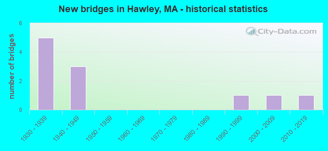
- New bridges - historical statistics
- 51930-1939
- 31940-1949
- 11990-1999
- 12000-2009
- 12010-2019
FCC Registered Antenna Towers:
3- Michael J Umano, 60 Energy Lane (Lat: 42.614861 Lon: -72.866583), Type: 60.9, Structure height: 25011 m, Overall height: 57.9 m, Registrant: Industrial Tower And Wireless, LLC, Kevin.Delaney@induscom.Com, , Marsh-field, Phone: (781) 319-1111
- Michael J Umano, 60 Energy Lane (Lat: 42.614861 Lon: -72.866583), Type: 60.9, Structure height: 25011 m, Overall height: 57.9 m, Registrant: Industrial Tower And Wireless, LLC, Kevin.Delaney@induscom.Com, , Marsh-field, Phone: (781) 319-1111
- Michael J Umano, 60 Energy Lane (Lat: 42.614861 Lon: -72.866583), Type: 60.9, Structure height: 25011 m, Overall height: 57.9 m, Registrant: Industrial Tower And Wireless, LLC, Kevin.Delaney@induscom.Com, , Marsh-field, Phone: (781) 319-1111
FCC Registered Amateur Radio Licenses:
3- Call Sign: N2YMR, Licensee ID: L00808998, Grant Date: 02/20/2014, Expiration Date: 04/12/2024, Certifier: Michael King, Registrant: Michael King, 62 Labelle Rd, Hawley, MA 01339-9724
- Call Sign: WB1DVK, Grant Date: 04/05/1995, Expiration Date: 04/05/2005, Cancellation Date: 04/06/2007, Registrant: Charles H Riggott, 12 Ashfield Rd, Hawley, MA 01339
- Call Sign: KB1ZYZ, Licensee ID: L01790427, Grant Date: 05/16/2023, Expiration Date: 05/21/2033, Certifier: Hussain A Hamdan, Registrant: Hussain A Hamdan, 45 Pudding Hollow Road, Hawley, MA 01339
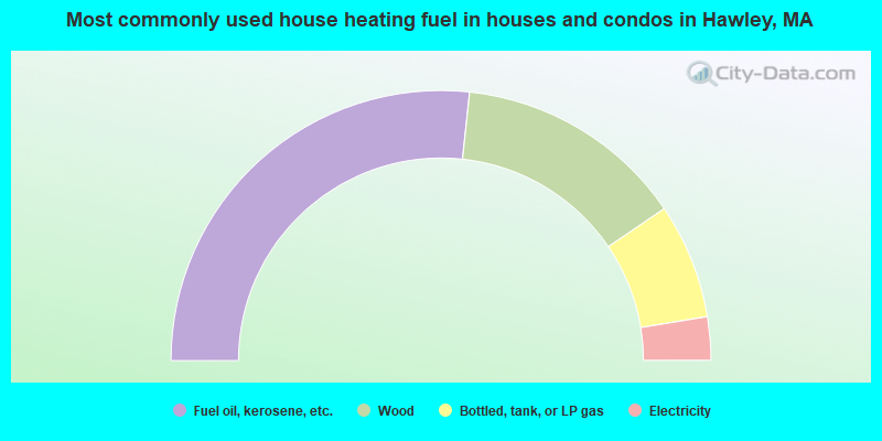
- 53.4%Fuel oil, kerosene, etc.
- 27.6%Wood
- 13.8%Bottled, tank, or LP gas
- 5.2%Electricity
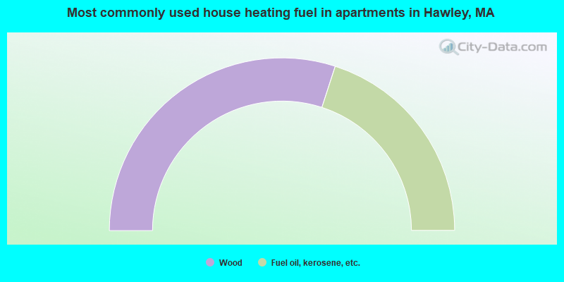
- 60.0%Wood
- 40.0%Fuel oil, kerosene, etc.
Hawley compared to Massachusetts state average:
- Median house value below state average.
- Unemployed percentage below state average.
- Black race population percentage significantly below state average.
- Hispanic race population percentage significantly below state average.
- Median age significantly above state average.
- Foreign-born population percentage significantly below state average.
- Renting percentage significantly below state average.
- Length of stay since moving in significantly above state average.
- Number of rooms per house significantly below state average.
- House age significantly below state average.
State forum archive: