Hart's Location, New Hampshire
Submit your own pictures of this town and show them to the world
- OSM Map
- Google Map
- MSN Map
Population change since 2000: +10.8%
 |
| Males: 23 | |
| Females: 18 |
| Median resident age: | 47.5 years |
| New Hampshire median age: | 43.9 years |
Zip code: 03812
| Hart's Location: | $78,730 |
| NH: | $89,992 |
Estimated per capita income in 2022: $44,017 (it was $19,609 in 2000)
Estimated median house or condo value in 2022: $478,178 (it was $156,300 in 2000)
| Hart's Location: | $478,178 |
| NH: | $384,700 |
Mean prices in 2022: all housing units: $505,201; detached houses: $542,950; townhouses or other attached units: $363,532; in 2-unit structures: $373,773; in 3-to-4-unit structures: $587,160; in 5-or-more-unit structures: $313,992; mobile homes: $113,714; occupied boats, rvs, vans, etc.: $118,400
Hart's Location, NH residents, houses, and apartments details
Compare current foreclosures near your location:
| Photo | Address | Area | Beds / Baths | Price | Details |
|---|---|---|---|---|---|

|
#1
E 21st Ave
Columbus, OH 43211
|
1,061 sq. feet
|
1 baths 3 beds |
$179,900
|
show details |

|
#2
S High St
Columbus, OH 43207
|
1,678 sq. feet
|
2 baths 4 beds |
$23,000
|
show details |

|
#3
Scott St
Columbus, OH 43222
|
1,920 sq. feet
|
2 baths 5 beds |
show details | |

|
#4
Lieutenant Dr
Galloway, OH 43119
|
1,848 sq. feet
|
3 baths 3 beds |
show details | |

|
#5
Meadowleigh Way
Columbus, OH 43230
|
976 sq. feet
|
3 baths 2 beds |
show details | |

|
#6
Lewis Rd
Columbus, OH 43207
|
1,976 sq. feet
|
2 baths 4 beds |
show details | |

|
#7
Blendon Point Dr
Columbus, OH 43230
|
896 sq. feet
|
2 baths 2 beds |
show details | |

|
#8
Clement Dr
Columbus, OH 43085
|
1,078 sq. feet
|
2 baths 3 beds |
show details | |

|
#9
Alderson Ct
Columbus, OH 43228
|
1,224 sq. feet
|
3 baths 3 beds |
show details | |

|
#10
Brentwood Rd
Columbus, OH 43209
|
3,716 sq. feet
|
4 baths 4 beds |
show details |
| Photo | Address | Area | Beds / Baths | Price | Details |
|---|---|---|---|---|---|

|
#11
Oldenburgh Way
Dublin, OH 43016
|
1,566 sq. feet
|
3 baths 3 beds |
show details | |

|
#12
Josephine Cir
Grove City, OH 43123
|
1,054 sq. feet
|
1 baths 3 beds |
show details | |

|
#13
Blendon Grove Way
Columbus, OH 43230
|
976 sq. feet
|
3 baths 2 beds |
show details | |

|
#14
Meadowsview Ln
Hilliard, OH 43026
|
2,972 sq. feet
|
4 baths 4 beds |
show details | |

|
#15
Holly River Ave
Dublin, OH 43016
|
1,335 sq. feet
|
3 baths 2 beds |
show details | |

|
#16
Dempsey Rd
Westerville, OH 43081
|
1,058 sq. feet
|
2 baths 3 beds |
show details | |

|
#17
Baker Hill Rd
Columbus, OH 43207
|
896 sq. feet
|
1 baths 3 beds |
show details | |

|
#18
Bitterroot Dr
Westerville, OH 43081
|
1,132 sq. feet
|
3 baths 3 beds |
show details | |

|
#19
Dunsworth Dr
Columbus, OH 43235
|
1,023 sq. feet
|
2 baths 3 beds |
show details | |

|
#20
Rohr Rd
Groveport, OH 43125
|
1,926 sq. feet
|
3 baths 3 beds |
show details |
| Photo | Address | Area | Beds / Baths | Price | Details |
|---|---|---|---|---|---|

|
#21
Sandrell Dr
Columbus, OH 43228
|
1,132 sq. feet
|
2 baths 3 beds |
show details | |

|
#22
Grove Cir
Columbus, OH 43230
|
1,236 sq. feet
|
2 baths 2 beds |
show details | |

|
#23
Rohr Rd
Groveport, OH 43125
|
1,212 sq. feet
|
1 baths 3 beds |
show details | |

|
#24
San Miguel Pl
Reynoldsburg, OH 43068
|
1,024 sq. feet
|
2 baths 2 beds |
show details | |

|
#25
E Livingston Ave
Reynoldsburg, OH 43068
|
1,404 sq. feet
|
2 baths 4 beds |
show details | |

|
#26
Legend
Columbus, OH 43230
|
2,100 sq. feet
|
3 baths 3 beds |
show details | |

|
#27
Old Ben Ln
Canal Winchester, OH 43110
|
1,316 sq. feet
|
2 baths 3 beds |
show details | |

|
#28
Chinquo St
Grove City, OH 43123
|
1,158 sq. feet
|
2 baths 3 beds |
show details | |

|
#29
N Dawson Ave
Columbus, OH 43219
|
888 sq. feet
|
2 baths 3 beds |
show details | |

|
#30
Scriven Ave
Columbus, OH 43228
|
832 sq. feet
|
2 baths 2 beds |
show details |
| Photo | Address | Area | Beds / Baths | Price | Details |
|---|---|---|---|---|---|

|
#31
Prairiefire Ave
Columbus, OH 43230
|
1,362 sq. feet
|
2 baths 3 beds |
show details | |

|
#32
Sweet Shadow Ave
Columbus, OH 43230
|
1,305 sq. feet
|
2 baths 3 beds |
show details | |

|
#33
Chatsworth Ct
Reynoldsburg, OH 43068
|
1,028 sq. feet
|
2 baths 3 beds |
show details | |

|
#34
Glen Village Dr
Dublin, OH 43016
|
1,517 sq. feet
|
3 baths 3 beds |
show details | |

|
#35
Dunkirk Dr
Columbus, OH 43219
|
924 sq. feet
|
1 baths 3 beds |
show details | |

|
#36
Pebblelane Dr
Columbus, OH 43085
|
1,212 sq. feet
|
1 baths 3 beds |
show details | |

|
#37
Elaine Rd
Columbus, OH 43213
|
764 sq. feet
|
1 baths 2 beds |
show details | |

|
#38
Idlebrook Ct
Galloway, OH 43119
|
1,720 sq. feet
|
3 baths 3 beds |
show details | |

|
#39
Battalion Pl
Galloway, OH 43119
|
1,552 sq. feet
|
2 baths 3 beds |
show details | |

|
#40
Granite Falls Dr
Blacklick, OH 43004
|
1,764 sq. feet
|
2 baths 3 beds |
show details |
| Photo | Address | Area | Beds / Baths | Price | Details |
|---|---|---|---|---|---|

|
#41
Alkire Rd
Grove City, OH 43123
|
1,680 sq. feet
|
3 baths 4 beds |
show details | |

|
#42
Flynnway Dr
Columbus, OH 43085
|
1,220 sq. feet
|
2 baths 3 beds |
show details | |

|
#43
Baldwin Rd
Reynoldsburg, OH 43068
|
1,024 sq. feet
|
2 baths 2 beds |
show details | |

|
#44
Maize Rd
Columbus, OH 43224
|
1,678 sq. feet
|
2 baths 3 beds |
show details | |

|
#45
Oakland Park Ave
Columbus, OH 43224
|
1,127 sq. feet
|
1 baths 3 beds |
show details | |

|
#46
Golden Cloud Ln
Columbus, OH 43228
|
1,576 sq. feet
|
3 baths 3 beds |
show details | |

|
#47
Meadowhaven Blvd
Columbus, OH 43235
|
1,024 sq. feet
|
2 baths 2 beds |
show details | |

|
#48
Shady Rock Ln
Blacklick, OH 43004
|
2,747 sq. feet
|
3 baths 4 beds |
show details | |

|
#49
Norahrow Dr
Columbus, OH 43085
|
1,220 sq. feet
|
2 baths 3 beds |
show details | |

|
Check over 1 million property listings on Foreclosure.com!
|
browse all offers | |||
 Recent articles from our blog. Our writers, many of them Ph.D. graduates or candidates, create easy-to-read articles on a wide variety of topics.
Ancestries: Irish (54.1%), German (40.5%), Italian (18.9%), Scotch-Irish (8.1%), Polish (5.4%).
Current Local Time: EST time zone
Incorporated in 1772
Land area: 18.6 square miles.
Population density: 2.2 people per square mile (very low).
| Hart's Location town: | 0.6% ($900) |
| New Hampshire: | 2.3% ($2,946) |
Nearest city with pop. 50,000+: Portland, ME  (64.0 miles , pop. 64,249).
Nearest city with pop. 200,000+: Boston, MA (126.9 miles , pop. 589,141).
Nearest city with pop. 1,000,000+: Bronx, NY (261.4 miles , pop. 1,332,650).
Nearest cities:
), Latitude: 44.14 N, Longitude: 71.37 W
Area code commonly used in this area: 603

Single-family new house construction building permits:
- 2018: 2 buildings, average cost: $325,000
- 2017: 3 buildings, average cost: $180,000
- 2012: 1 building, cost: $190,000
- 2010: 1 building, cost: $187,000
- 2009: 1 building, cost: $150,000
- 2008: 1 building, cost: $150,000
- 2003: 1 building, cost: $400,000
- 2000: 3 buildings, average cost: $59,200
- 1999: 2 buildings, average cost: $275,000
- 1998: 1 building, cost: $150,000


| Here: | 0.0% |
| New Hampshire: | 2.5% |

Average climate in Hart's Location, New Hampshire
Based on data reported by over 4,000 weather stations


(lower is better)

Air Quality Index (AQI) level in 2022 was 46.4. This is significantly better than average.
| City: | 46.4 |
| U.S.: | 72.6 |

Ozone [ppb] level in 2022 was 34.4. This is about average. Closest monitor was 9.2 miles away from the city center.
| City: | 34.4 |
| U.S.: | 33.3 |
Tornado activity:
Hart's Location-area historical tornado activity is significantly below New Hampshire state average. It is 79% smaller than the overall U.S. average.
On 8/11/1966, a category F2 (max. wind speeds 113-157 mph) tornado 28.4 miles away from the Hart's Location town center caused between $50,000 and $500,000 in damages.
On 7/18/1963, a category F2 tornado 38.6 miles away from the town center caused between $5000 and $50,000 in damages.
Earthquake activity:
Hart's Location-area historical earthquake activity is significantly above New Hampshire state average. It is 73% smaller than the overall U.S. average.On 4/20/2002 at 10:50:47, a magnitude 5.3 (5.3 ML, Depth: 3.0 mi, Class: Moderate, Intensity: VI - VII) earthquake occurred 118.0 miles away from Hart's Location center
On 4/20/2002 at 10:50:47, a magnitude 5.2 (5.2 MB, 4.2 MS, 5.2 MW, 5.0 MW) earthquake occurred 118.7 miles away from Hart's Location center
On 10/7/1983 at 10:18:46, a magnitude 5.3 (5.1 MB, 5.3 LG, 5.1 ML) earthquake occurred 148.4 miles away from the city center
On 1/19/1982 at 00:14:42, a magnitude 4.7 (4.5 MB, 4.7 MD, 4.5 LG, Class: Light, Intensity: IV - V) earthquake occurred 46.1 miles away from Hart's Location center
On 10/16/2012 at 23:12:25, a magnitude 4.7 (4.7 ML, Depth: 10.0 mi) earthquake occurred 51.9 miles away from Hart's Location center
On 8/21/1996 at 07:54:14, a magnitude 3.8 (3.8 LG, 3.6 LG, Depth: 6.2 mi, Class: Light, Intensity: II - III) earthquake occurred 2.8 miles away from the city center
Magnitude types: regional Lg-wave magnitude (LG), body-wave magnitude (MB), duration magnitude (MD), local magnitude (ML), surface-wave magnitude (MS), moment magnitude (MW)
Natural disasters:
The number of natural disasters in Carroll County (29) is a lot greater than the US average (15).Major Disasters (Presidential) Declared: 17
Emergencies Declared: 9
Causes of natural disasters: Storms: 12, Floods: 11, Winter Storms: 5, Hurricanes: 4, Snows: 4, Snowstorms: 2, Blizzard: 1, Heavy Rain: 1, Ice Storm: 1, Snowfall: 1, Tornado: 1, Tropical Storm: 1, Wind: 1, Other: 1 (Note: some incidents may be assigned to more than one category).
Colleges/universities with over 2000 students nearest to Hart's Location:
- Plymouth State University (about 32 miles; Plymouth, NH; Full-time enrollment: 4,838)
- Saint Joseph's College of Maine (about 50 miles; Standish, ME; FT enrollment: 2,010)
- Dartmouth College (about 56 miles; Hanover, NH; FT enrollment: 6,030)
- University of Southern Maine (about 64 miles; Portland, ME; FT enrollment: 6,647)
- Norwich University (about 65 miles; Northfield, VT; FT enrollment: 4,221)
- NHTI-Concord's Community College (about 65 miles; Concord, NH; FT enrollment: 2,865)
- Southern Maine Community College (about 67 miles; South Portland, ME; FT enrollment: 4,666)
Points of interest:
Notable locations in Hart's Location: Willey House (A), Willey House Camps (B), Dry River Camping Area (C), Sawyer Rock Picnic Area (D), Dry River Campground (E), Sawyer Rock Picnic Area (F). Display/hide their locations on the map
Streams, rivers, and creeks: Willey Brook (A), Halfway Brook (B), Flume Cascade (C), Dry River (D), Davis Brook (E), Sawyer River (F), Bemis Brook (G), Avalanche Brook (H), Nancy Brook (I). Display/hide their locations on the map
| This town: | 1.9 people |
| New Hampshire: | 2.5 people |
| This town: | 57.1% |
| Whole state: | 66.3% |
| This town: | 9.5% |
| Whole state: | 8.3% |
No gay or lesbian households reported
For population 15 years and over in Hart's Location:

- Never married: 21.7%
- Now married: 69.6%
- Separated: 0.0%
- Widowed: 0.0%
- Divorced: 8.7%
For population 25 years and over in Hart's Location:
- High school or higher: 90.5%
- Bachelor's degree or higher: 52.4%
- Graduate or professional degree: 14.3%
- Unemployed: 14.3%
- Mean travel time to work (commute): 12.3 minutes


| Here: | 8.1 |
| New Hampshire average: | 10.9 |
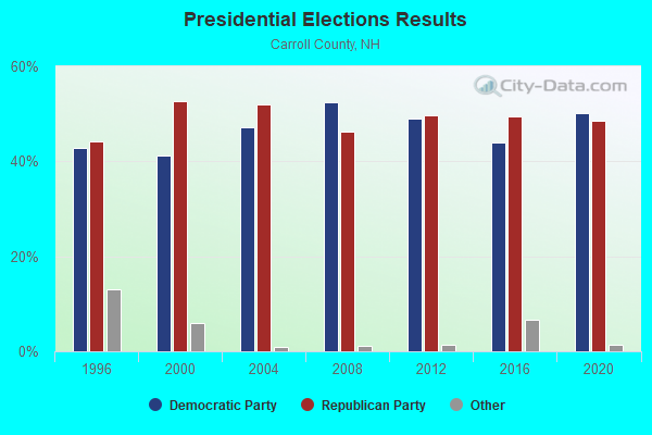
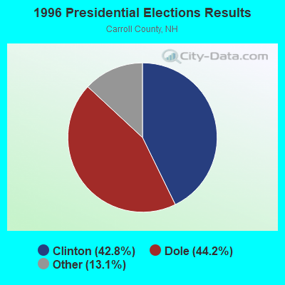
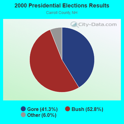


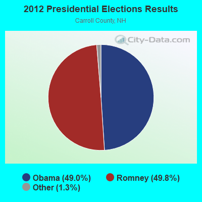


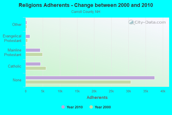
Graphs represent county-level data. Detailed 2008 Election Results
Religion statistics for Hart's Location, NH (based on Carroll County data)
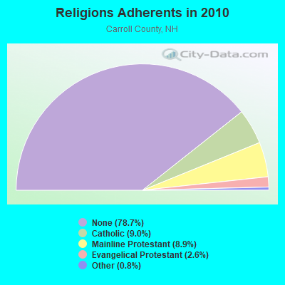
| Religion | Adherents | Congregations |
|---|---|---|
| Catholic | 4,304 | 2 |
| Mainline Protestant | 4,266 | 30 |
| Evangelical Protestant | 1,241 | 14 |
| Other | 366 | 5 |
| None | 37,641 | - |
Food Environment Statistics:
| Carroll County: | 4.23 / 10,000 pop. |
| New Hampshire: | 2.14 / 10,000 pop. |
| This county: | 2.54 / 10,000 pop. |
| State: | 1.78 / 10,000 pop. |
| Carroll County: | 8.47 / 10,000 pop. |
| New Hampshire: | 4.02 / 10,000 pop. |
| Here: | 24.13 / 10,000 pop. |
| New Hampshire: | 9.70 / 10,000 pop. |
| Carroll County: | 8.8% |
| New Hampshire: | 7.6% |
| This county: | 21.2% |
| New Hampshire: | 24.4% |
| Here: | 16.9% |
| New Hampshire: | 15.9% |
Strongest AM radio stations in Hart's Location:
- WRKO (680 AM; 50 kW; BOSTON, MA; Owner: ENTERCOM BOSTON LICENSE, LLC)
- WTME (780 AM; 10 kW; RUMFORD, ME; Owner: MOUNTAIN VALLEY BROADCASTING, INC.)
- WPNH (1300 AM; 5 kW; PLYMOUTH, NH; Owner: NORTHEAST COMMUNICATIONS CORPORATION)
- WTWN (1100 AM; daytime; 5 kW; WELLS RIVER, VT; Owner: PUFFER BROADCASTING, INC.)
- WMTW (870 AM; 10 kW; GORHAM, ME; Owner: RADIO PARTNERS OF MAINE, L.P.)
- WEEI (850 AM; 50 kW; BOSTON, MA; Owner: ENTERCOM BOSTON LICENSE, LLC)
- WCHP (760 AM; 35 kW; CHAMPLAIN, NY; Owner: CHAMPLAIN RADIO, INC.)
- WCRN (830 AM; 50 kW; WORCESTER, MA; Owner: CARTER BROADCASTING CORPORATION)
- WBNC (1050 AM; 1 kW; CONWAY, NH; Owner: MT. WASHINGTON RADIO & GRAMOPHONE, L.L.C.)
- WNNZ (640 AM; 50 kW; WESTFIELD, MA; Owner: CLEAR CHANNEL BROADCASTING LICENSES, INC.)
- WBZ (1030 AM; 50 kW; BOSTON, MA; Owner: INFINITY BROADCASTING OPERATIONS, INC.)
- WGIN (930 AM; 10 kW; ROCHESTER, NH; Owner: CAPSTAR TX LIMITED PARTNERSHIP)
- WKOX (1200 AM; 50 kW; FRAMINGHAM, MA; Owner: CAPSTAR TX LIMITED PARTNERSHIP)
Strongest FM radio stations in Hart's Location:
- WPKQ (103.7 FM; NORTH CONWAY, NH; Owner: CITADEL BROADCASTING COMPANY)
- WHOM (94.9 FM; MT. WASHINGTON, NH; Owner: CITADEL BROADCASTING COMPANY)
- WVFM (105.7 FM; CAMPTON, NH; Owner: DEVON BROADCASTING COMPANY, INC.)
- WSCY (106.9 FM; MOULTONBOROUGH, NH; Owner: NORTHEAST COMMUNICATIONS CORPORATION)
- WMTK (106.3 FM; LITTLETON, NH; Owner: VERMONT BROADCAST ASSOCIATES, INC.)
- WGMT (97.7 FM; LYNDON, VT; Owner: VERMONT BROADCAST ASSOCIATES, INC.)
- WXXS (102.3 FM; LANCASTER, NH; Owner: BARRY P. LUNDERVILLE)
- WMEA (90.1 FM; PORTLAND, ME; Owner: MAINE PUBLIC BROADCASTING CORPORATION)
- WPNH-FM (100.1 FM; PLYMOUTH, NH; Owner: NORTHEAST COMMUNICATIONS CORPORATION)
- WMWV (93.5 FM; CONWAY, NH; Owner: MT. WASHINGTON RADIO & GRAMOPHONE, L.L.C.)
- WLOB-FM (96.3 FM; RUMFORD, ME; Owner: ATLANTIC COAST RADIO, LLC)
- WBLM (102.9 FM; PORTLAND, ME; Owner: CITADEL BROADCASTING COMPANY)
- WLTN-FM (96.7 FM; LISBON, NH; Owner: PROFILE BROADCASTING CO., INC.)
- WTBM (100.7 FM; MEXICO, ME; Owner: MOUNTAIN VALLEY BROADCASTING, INC.)
- WLKZ (104.9 FM; WOLFEBORO, NH; Owner: TELE-MEDIA COMPANY OF NEW HAMPSHIRE, L.L.C.)
- WVMJ (104.5 FM; CONWAY, NH; Owner: MT. WASHINGTON RADIO & GRAMOPHONE, L.L.C.)
- WDOT (95.7 FM; DANVILLE, VT; Owner: MONTPELIER BROADCASTING INC)
- WEVH (91.3 FM; HANOVER, NH; Owner: NEW HAMPSHIRE PUBLIC RADIO INC)
- WCKJ (90.5 FM; ST. JOHNSBURY, VT; Owner: CHRISTIAN MINISTRIES, INC.)
- WKXH (105.5 FM; ST. JOHNSBURY, VT; Owner: VERMONT BROADCAST ASSOCIATES, INC.)
TV broadcast stations around Hart's Location:
- WMTW-TV (Channel 8; POLAND SPRING, ME; Owner: WMTW BROADCAST GROUP, LLC)
- WCSH (Channel 6; PORTLAND, ME; Owner: PACIFIC AND SOUTHERN COMPANY, INC.)
- WGME-TV (Channel 13; PORTLAND, ME; Owner: WGME LICENSEE, LLC)
- WLED-TV (Channel 49; LITTLETON, NH; Owner: UNIVERSITY OF NEW HAMPSHIRE)
- National Bridge Inventory (NBI) Statistics
- 10Number of bridges
- 72ft / 22.3mTotal length
- $31,420,000Total costs
- 21,944Total average daily traffic
- 1,409Total average daily truck traffic
- 32,472Total future (year 2042) average daily traffic

- New bridges - historical statistics
- 11930-1939
- 11940-1949
- 11950-1959
- 11960-1969
- 51970-1979
- 12010-2019
Hart's Location compared to New Hampshire state average:
- Black race population percentage significantly below state average.
- Hispanic race population percentage significantly below state average.
- Foreign-born population percentage significantly below state average.
- Length of stay since moving in significantly above state average.
- Number of rooms per house significantly below state average.
- House age significantly below state average.
- Percentage of population with a bachelor's degree or higher above state average.