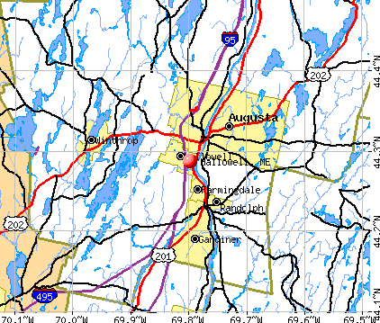
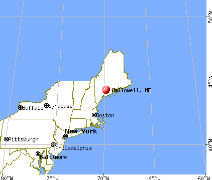
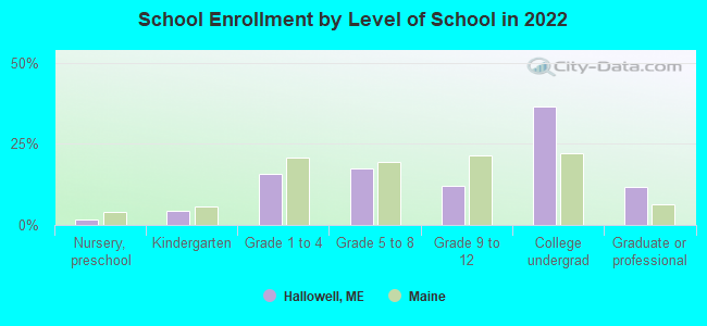
Hallowell, Maine

Hallowell: Water Street

Hallowell: Reflections............
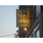
Hallowell: What's Hallowell Without Slates?
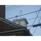
Hallowell: Things Are Looking Up
- add
your
Submit your own pictures of this city and show them to the world
- OSM Map
- General Map
- Google Map
- MSN Map
Population change since 2000: +5.3%
 |
| Males: 1,230 | |
| Females: 1,367 |
| Median resident age: | 49.3 years |
| Maine median age: | 45.1 years |
Zip codes: 04347.
| Hallowell: | $63,827 |
| ME: | $69,543 |
Estimated per capita income in 2022: $45,021 (it was $20,457 in 2000)
Hallowell city income, earnings, and wages data
Estimated median house or condo value in 2022: $273,918 (it was $96,500 in 2000)
| Hallowell: | $273,918 |
| ME: | $290,600 |
Mean prices in 2022: all housing units: $313,632; detached houses: $324,503; townhouses or other attached units: $323,355; in 2-unit structures: $317,861; in 3-to-4-unit structures: $145,902; in 5-or-more-unit structures: $173,064
Median gross rent in 2022: $877.
(11.5% for White Non-Hispanic residents, 100.0% for two or more races residents)
Detailed information about poverty and poor residents in Hallowell, ME
Compare current foreclosures near Hallowell, ME:
| Photo | Address | Area | Beds / Baths | Price | Details |
|---|---|---|---|---|---|

|
#1
Row House Ln
Hallowell, ME 04347
|
- sq. feet
|
- baths - beds |
show details | |

|
#2
Middle St
Hallowell, ME 04347
|
- sq. feet
|
- baths - beds |
show details | |

|
#3
Dr Mann Rd
Augusta, ME 04330
|
1,320 sq. feet
|
2 baths 2 beds |
$299,900
|
show details |

|
#4
Riverside Dr
Vassalboro, ME 04989
|
1,510 sq. feet
|
2 baths 4 beds |
$350,000
|
show details |

|
#5
Washington St
Augusta, ME 04330
|
1,478 sq. feet
|
2 baths 3 beds |
$77,050
|
show details |

|
#6
Jameson Ln
Wayne, ME 04284
|
1,312 sq. feet
|
2 baths 3 beds |
show details | |

|
#7
Alexander Reed Rd
Richmond, ME 04357
|
2,591 sq. feet
|
1 baths 3 beds |
show details | |

|
#8
Langdon Rd
Richmond, ME 04357
|
1,509 sq. feet
|
1 baths 3 beds |
show details | |

|
#9
Bog Rd
Mount Vernon, ME 04352
|
1,704 sq. feet
|
3 baths 3 beds |
show details | |

|
#10
River Rd
Richmond, ME 04357
|
1,560 sq. feet
|
2 baths 3 beds |
show details |
| Photo | Address | Area | Beds / Baths | Price | Details |
|---|---|---|---|---|---|

|
#11
Old Brunswick Rd
Gardiner, ME 04345
|
1,056 sq. feet
|
1 baths 2 beds |
show details | |

|
#12
Larry Dr
Monmouth, ME 04259
|
816 sq. feet
|
1 baths 1 beds |
show details | |

|
#13
Pond Rd
South China, ME 04358
|
1,851 sq. feet
|
2 baths 3 beds |
show details | |

|
#14
Macmaster Ln
Gardiner, ME 04345
|
2,992 sq. feet
|
3 baths 4 beds |
show details | |

|
#15
Belgrade Rd
Manchester, ME 04351
|
1,100 sq. feet
|
2 baths 3 beds |
show details | |

|
#16
Costello Rd
Gardiner, ME 04345
|
784 sq. feet
|
1 baths 2 beds |
show details | |

|
#17
Highland Hts
Winthrop, ME 04364
|
1,800 sq. feet
|
2 baths 4 beds |
show details | |

|
#18
Whispering Pines Cir
Wayne, ME 04284
|
1,164 sq. feet
|
1 baths 3 beds |
show details | |

|
#19
Riverside Dr
Augusta, ME 04330
|
874 sq. feet
|
2 baths 2 beds |
show details | |

|
#20
Worthing Rd
Manchester, ME 04351
|
1,408 sq. feet
|
2 baths 5 beds |
show details |
| Photo | Address | Area | Beds / Baths | Price | Details |
|---|---|---|---|---|---|

|
#21
Campers Point Rd
Winthrop, ME 04364
|
1,353 sq. feet
|
2 baths 1 beds |
show details | |

|
#22
Cottle Rd
Oakland, ME 04963
|
1,232 sq. feet
|
2 baths 3 beds |
show details | |

|
#23
Brunswick Ave
Gardiner, ME 04345
|
4,801 sq. feet
|
4 baths 5 beds |
show details | |

|
#24
Florence St
Augusta, ME 04330
|
1,109 sq. feet
|
1 baths 3 beds |
show details | |

|
#25
Brookside Ave
Augusta, ME 04330
|
936 sq. feet
|
2 baths 2 beds |
show details | |

|
#26
Fontaine St
Augusta, ME 04330
|
1,064 sq. feet
|
1 baths 2 beds |
show details | |

|
#27
Longwood Ave
Augusta, ME 04330
|
1,274 sq. feet
|
1 baths 3 beds |
show details | |

|
#28
Key Hill Rd
Greene, ME 04236
|
1,328 sq. feet
|
1 baths 3 beds |
show details | |

|
#29
Main St
Wayne, ME 04284
|
1,800 sq. feet
|
2 baths - beds |
show details | |

|
#30
Cressey Rd
Monmouth, ME 04259
|
2,503 sq. feet
|
2 baths 4 beds |
show details |
| Photo | Address | Area | Beds / Baths | Price | Details |
|---|---|---|---|---|---|

|
#31
Eastern Ave
Augusta, ME 04330
|
1,344 sq. feet
|
2 baths 3 beds |
show details | |

|
#32
Riverside Dr
Augusta, ME 04330
|
1,724 sq. feet
|
2 baths 3 beds |
show details | |

|
#33
Mount Pisgah Rd
Wayne, ME 04284
|
3,024 sq. feet
|
2 baths - beds |
show details | |

|
#34
W River Rd
Augusta, ME 04330
|
1,440 sq. feet
|
2 baths 4 beds |
show details | |

|
#35
Highland Hts
Winthrop, ME 04364
|
1,800 sq. feet
|
1 baths 4 beds |
show details | |

|
#36
Strout Ln
Augusta, ME 04330
|
1,080 sq. feet
|
- baths - beds |
show details | |

|
#37
Indian Rd
Dresden, ME 04342
|
3,054 sq. feet
|
3 baths - beds |
show details | |

|
#38
Marsh Rd
Sabattus, ME 04280
|
1,932 sq. feet
|
2 baths - beds |
show details | |

|
#39
Cross Hill Rd
Vassalboro, ME 04989
|
- sq. feet
|
- baths - beds |
show details | |

|
#40
Gleason Farm Rd
Oakland, ME 04963
|
- sq. feet
|
- baths - beds |
show details |
| Photo | Address | Area | Beds / Baths | Price | Details |
|---|---|---|---|---|---|

|
#41
Church St
Gardiner, ME 04345
|
- sq. feet
|
- baths - beds |
show details | |

|
#42
Cape Hill Rd
Jefferson, ME 04348
|
- sq. feet
|
- baths - beds |
show details | |

|
#43
Meadow Rd Apt 204
Augusta, ME 04330
|
- sq. feet
|
- baths - beds |
show details | |

|
#44
Pleasant St # 2
Augusta, ME 04330
|
- sq. feet
|
- baths - beds |
show details | |

|
#45
White Rd
Bowdoinham, ME 04008
|
- sq. feet
|
- baths - beds |
show details | |

|
#46
Daniel Dr
Gardiner, ME 04345
|
- sq. feet
|
- baths - beds |
show details | |

|
#47
Bangor St
Augusta, ME 04330
|
- sq. feet
|
- baths - beds |
show details | |

|
#48
Mount Vernon Ave # 2
Augusta, ME 04330
|
- sq. feet
|
- baths - beds |
show details | |

|
#49
Church Hill Rd
Augusta, ME 04330
|
- sq. feet
|
- baths - beds |
show details | |

|
Check over 1 million property listings on Foreclosure.com!
|
browse all offers | |||


- 2,51597.1%White alone
- 120.5%Two or more races
- 140.5%Hispanic
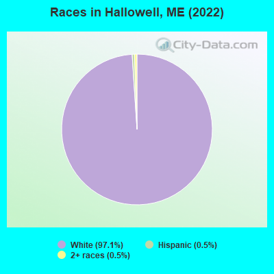
Races in Hallowell detailed stats: ancestries, foreign born residents, place of birth
Type |
2009 |
2010 |
2011 |
2012 |
2013 |
2014 |
2015 |
2016 |
2017 |
2018 |
2019 |
2020 |
2021 |
2022 |
|---|---|---|---|---|---|---|---|---|---|---|---|---|---|---|
| Murders (per 100,000) | 0 (0.0) | 1 (42.0) | 0 (0.0) | 0 (0.0) | 0 (0.0) | 0 (0.0) | 0 (0.0) | 0 (0.0) | 0 (0.0) | 0 (0.0) | 0 (0.0) | 0 (0.0) | 0 (0.0) | 0 (0.0) |
| Rapes (per 100,000) | 0 (0.0) | 0 (0.0) | 0 (0.0) | 0 (0.0) | 1 (42.3) | 0 (0.0) | 0 (0.0) | 0 (0.0) | 1 (43.1) | 1 (42.3) | 0 (0.0) | 0 (0.0) | 0 (0.0) | 0 (0.0) |
| Robberies (per 100,000) | 0 (0.0) | 0 (0.0) | 1 (42.0) | 0 (0.0) | 0 (0.0) | 1 (42.8) | 0 (0.0) | 0 (0.0) | 0 (0.0) | 0 (0.0) | 2 (84.4) | 0 (0.0) | 0 (0.0) | 0 (0.0) |
| Assaults (per 100,000) | 0 (0.0) | 0 (0.0) | 0 (0.0) | 0 (0.0) | 3 (127.0) | 2 (85.7) | 1 (43.1) | 1 (43.4) | 0 (0.0) | 1 (42.3) | 2 (84.4) | 1 (42.0) | 0 (0.0) | 1 (38.8) |
| Burglaries (per 100,000) | 20 (821.7) | 13 (546.0) | 17 (714.0) | 16 (672.6) | 10 (423.4) | 4 (171.3) | 5 (215.7) | 2 (86.8) | 4 (172.6) | 1 (42.3) | 3 (126.5) | 4 (167.9) | 0 (0.0) | 2 (77.5) |
| Thefts (per 100,000) | 31 (1,274) | 51 (2,142) | 64 (2,688) | 72 (3,026) | 48 (2,032) | 39 (1,670) | 30 (1,294) | 18 (781.6) | 23 (992.2) | 13 (550.1) | 9 (379.6) | 15 (629.7) | 11 (461.0) | 12 (465.3) |
| Auto thefts (per 100,000) | 1 (41.1) | 2 (84.0) | 1 (42.0) | 3 (126.1) | 2 (84.7) | 0 (0.0) | 1 (43.1) | 3 (130.3) | 2 (86.3) | 0 (0.0) | 0 (0.0) | 0 (0.0) | 0 (0.0) | 3 (116.3) |
| Arson (per 100,000) | 1 (41.1) | 1 (42.0) | 0 (0.0) | 0 (0.0) | 0 (0.0) | 0 (0.0) | 0 (0.0) | 0 (0.0) | 0 (0.0) | 0 (0.0) | 0 (0.0) | 0 (0.0) | 0 (0.0) | 0 (0.0) |
| City-Data.com crime index | 111.8 | 214.6 | 173.5 | 178.2 | 177.0 | 108.8 | 78.9 | 56.4 | 93.2 | 67.3 | 66.2 | 45.3 | 18.4 | 41.1 |
The City-Data.com crime index weighs serious crimes and violent crimes more heavily. Higher means more crime, U.S. average is 246.1. It adjusts for the number of visitors and daily workers commuting into cities.
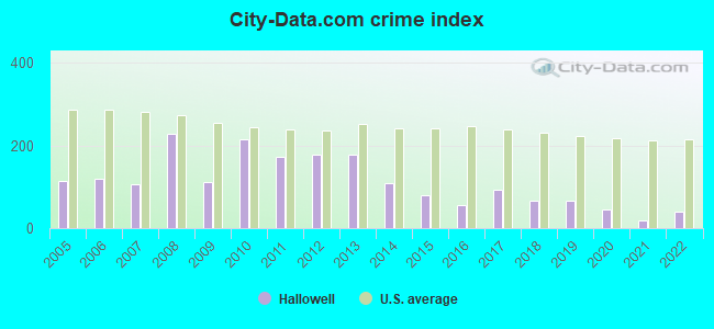
Crime rate in Hallowell detailed stats: murders, rapes, robberies, assaults, burglaries, thefts, arson
Full-time law enforcement employees in 2021, including police officers: 5 (5 officers - 4 male; 1 female).
| Officers per 1,000 residents here: | 2.10 |
| Maine average: | 1.71 |
 Recent articles from our blog. Our writers, many of them Ph.D. graduates or candidates, create easy-to-read articles on a wide variety of topics.

 | Hallowell and area schools (4 replies) |
| Retirement Ideas -Hallowell (13 replies) |
| Done with Colorado (12 replies) |
| Thoughts and opinions about Living in Augusta (23 replies) |
| Can you live well in any town in Maine without a car??? (41 replies) |
| Moving to Maine - Advice/Good-to-know Please (62 replies) |
Latest news from Hallowell, ME collected exclusively by city-data.com from local newspapers, TV, and radio stations
Ancestries: French (19.4%), English (13.7%), French Canadian (11.6%), American (10.3%), Irish (9.1%), German (6.1%).
Current Local Time: EST time zone
Incorporated on 04/26/1771
Elevation: 56 feet
Land area: 5.87 square miles.
Population density: 442 people per square mile (low).
49 residents are foreign born
| This city: | 1.9% |
| Maine: | 3.8% |
Median real estate property taxes paid for housing units with mortgages in 2022: $3,358 (1.0%)
Median real estate property taxes paid for housing units with no mortgage in 2022: $3,178 (1.4%)
Nearest city with pop. 50,000+: Portland, ME  (49.0 miles , pop. 64,249).
Nearest city with pop. 200,000+: Boston, MA (150.7 miles , pop. 589,141).
Nearest city with pop. 1,000,000+: Bronx, NY (315.7 miles , pop. 1,332,650).
Nearest cities:
), ), ), ), )Latitude: 44.29 N, Longitude: 69.80 W
Area code commonly used in this area: 207

Hallowell, Maine accommodation & food services, waste management - Economy and Business Data
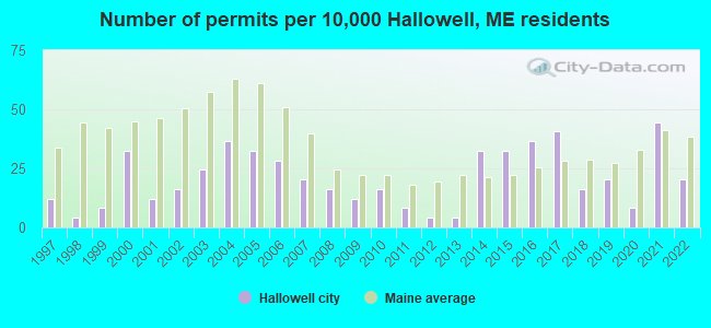
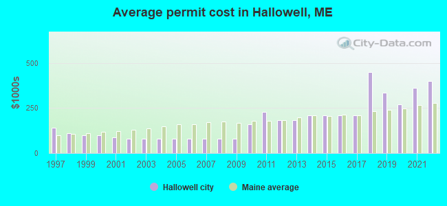
Single-family new house construction building permits:
- 2022: 5 buildings, average cost: $400,000
- 2021: 11 buildings, average cost: $363,600
- 2020: 2 buildings, average cost: $269,000
- 2019: 5 buildings, average cost: $336,000
- 2018: 4 buildings, average cost: $450,000
- 2017: 10 buildings, average cost: $211,100
- 2016: 9 buildings, average cost: $211,100
- 2015: 8 buildings, average cost: $211,100
- 2014: 8 buildings, average cost: $211,100
- 2013: 1 building, cost: $181,800
- 2012: 1 building, cost: $181,800
- 2011: 2 buildings, average cost: $229,000
- 2010: 4 buildings, average cost: $162,100
- 2009: 3 buildings, average cost: $80,200
- 2008: 4 buildings, average cost: $80,200
- 2007: 5 buildings, average cost: $80,200
- 2006: 7 buildings, average cost: $80,200
- 2005: 8 buildings, average cost: $80,200
- 2004: 9 buildings, average cost: $80,200
- 2003: 6 buildings, average cost: $80,300
- 2002: 4 buildings, average cost: $78,700
- 2001: 3 buildings, average cost: $88,300
- 2000: 8 buildings, average cost: $101,000
- 1999: 2 buildings, average cost: $100,000
- 1998: 1 building, cost: $110,000
- 1997: 3 buildings, average cost: $142,700
| Here: | 2.9% |
| Maine: | 3.4% |


- Public administration (16.0%)
- Health care (14.2%)
- Educational services (9.0%)
- Accommodation & food services (6.3%)
- Professional, scientific, technical services (5.7%)
- Construction (4.0%)
- Religious, grantmaking, civic, professional, similar organizations (3.1%)
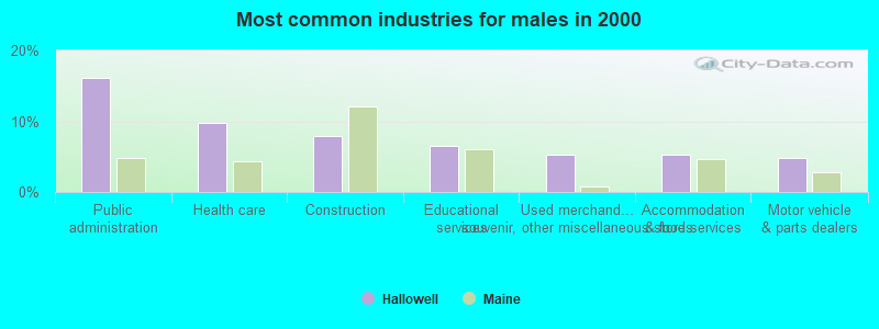
- Public administration (16.1%)
- Health care (9.7%)
- Construction (8.0%)
- Educational services (6.5%)
- Used merchandise, gift, novelty, souvenir, other miscellaneous stores (5.3%)
- Accommodation & food services (5.3%)
- Motor vehicle & parts dealers (4.8%)

- Health care (18.0%)
- Public administration (15.9%)
- Educational services (11.1%)
- Professional, scientific, technical services (7.8%)
- Accommodation & food services (7.1%)
- Finance & insurance (4.6%)
- Social assistance (4.1%)

- Other sales and related occupations, including supervisors (5.9%)
- Other management occupations, except farmers and farm managers (5.5%)
- Secretaries and administrative assistants (4.8%)
- Counselors, social workers, and other community and social service specialists (4.7%)
- Electrical equipment mechanics and other installation, maintenance, and repair workers, including supervisors (4.3%)
- Preschool, kindergarten, elementary, and middle school teachers (3.9%)
- Registered nurses (3.4%)
- Electrical equipment mechanics and other installation, maintenance, and repair workers, including supervisors (8.7%)
- Other management occupations, except farmers and farm managers (8.3%)
- Computer specialists (5.8%)
- Top executives (5.3%)
- Other sales and related occupations, including supervisors (4.4%)
- Lawyers (3.5%)
- Advertising, marketing, promotions, public relations, and sales managers (3.0%)

- Secretaries and administrative assistants (8.8%)
- Other sales and related occupations, including supervisors (7.2%)
- Counselors, social workers, and other community and social service specialists (6.6%)
- Preschool, kindergarten, elementary, and middle school teachers (6.3%)
- Registered nurses (5.9%)
- Bookkeeping, accounting, and auditing clerks (5.3%)
- Accountants and auditors (3.4%)
Average climate in Hallowell, Maine
Based on data reported by over 4,000 weather stations


(lower is better)
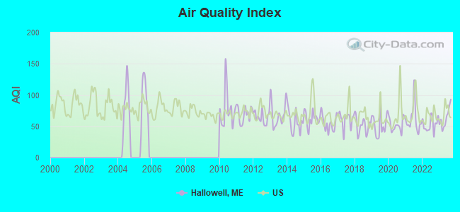
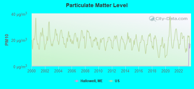
Air Quality Index (AQI) level in 2023 was 63.3. This is about average.
| City: | 63.3 |
| U.S.: | 72.6 |
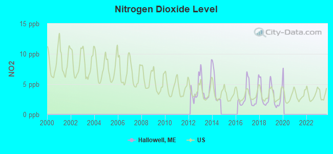
Nitrogen Dioxide (NO2) [ppb] level in 2019 was 2.80. This is significantly better than average. Closest monitor was 2.5 miles away from the city center.
| City: | 2.80 |
| U.S.: | 5.11 |
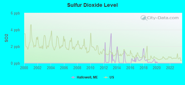
Sulfur Dioxide (SO2) [ppb] level in 2019 was 0.185. This is significantly better than average. Closest monitor was 2.5 miles away from the city center.
| City: | 0.185 |
| U.S.: | 1.515 |
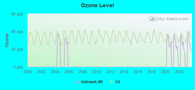
Ozone [ppb] level in 2023 was 29.5. This is about average. Closest monitor was 1.7 miles away from the city center.
| City: | 29.5 |
| U.S.: | 33.3 |
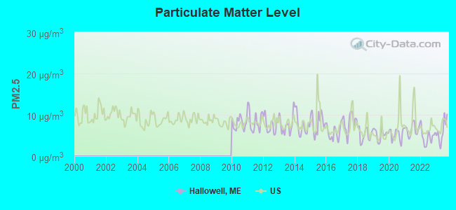
Particulate Matter (PM2.5) [µg/m3] level in 2023 was 6.09. This is better than average. Closest monitor was 1.8 miles away from the city center.
| City: | 6.09 |
| U.S.: | 8.11 |
Earthquake activity:
Hallowell-area historical earthquake activity is significantly above Maine state average. It is 76% smaller than the overall U.S. average.On 10/16/2012 at 23:12:25, a magnitude 4.7 (4.7 ML, Depth: 10.0 mi, Class: Light, Intensity: IV - V) earthquake occurred 64.0 miles away from the city center
On 4/20/2002 at 10:50:47, a magnitude 5.3 (5.3 ML, Depth: 3.0 mi, Class: Moderate, Intensity: VI - VII) earthquake occurred 193.3 miles away from Hallowell center
On 4/20/2002 at 10:50:47, a magnitude 5.2 (5.2 MB, 4.2 MS, 5.2 MW, 5.0 MW) earthquake occurred 194.2 miles away from the city center
On 1/19/1982 at 00:14:42, a magnitude 4.7 (4.5 MB, 4.7 MD, 4.5 LG) earthquake occurred 105.0 miles away from the city center
On 10/7/1983 at 10:18:46, a magnitude 5.3 (5.1 MB, 5.3 LG, 5.1 ML) earthquake occurred 226.8 miles away from the city center
On 2/26/1999 at 03:38:43, a magnitude 3.8 (3.8 LG, Depth: 2.0 mi, Class: Light, Intensity: II - III) earthquake occurred 19.2 miles away from the city center
Magnitude types: regional Lg-wave magnitude (LG), body-wave magnitude (MB), duration magnitude (MD), local magnitude (ML), surface-wave magnitude (MS), moment magnitude (MW)
Natural disasters:
The number of natural disasters in Kennebec County (21) is greater than the US average (15).Major Disasters (Presidential) Declared: 16
Emergencies Declared: 4
Causes of natural disasters: Floods: 13, Storms: 11, Snows: 5, Hurricanes: 3, Heavy Rains: 2, Blizzard: 1, Ice Storm: 1, Snowfall: 1, Wind: 1, Other: 2 (Note: some incidents may be assigned to more than one category).
Hospitals and medical centers near Hallowell:
- SUPPORTIVE LIVING SYSTEMS INC (Home Health Center, about 2 miles away; AUGUSTA, ME)
- MAINE GENERAL REHAB AND NURSING AT GLENRIDGE (Nursing Home, about 3 miles away; AUGUSTA, ME)
- RIVERVIEW PSYCHIATRIC CENTER (Hospital, about 3 miles away; AUGUSTA, ME)
- KENNEBEC VALLEY MEDICAL CENTER (Hospital, about 3 miles away; AUGUSTA, ME)
- KINDRED TRANSITIONAL CARE AND REHAB-AUGUSTA (Nursing Home, about 3 miles away; AUGUSTA, ME)
- MAINE VETERANS HOME - AUGUSTA (Nursing Home, about 3 miles away; AUGUSTA, ME)
- MERRILL MEMORIAL MANOR (Nursing Home, about 5 miles away; GARDINER, ME)
Colleges/universities with over 2000 students nearest to Hallowell:
- University of Maine at Augusta (about 4 miles; Augusta, ME; Full-time enrollment: 3,204)
- University of Maine at Farmington (about 32 miles; Farmington, ME; FT enrollment: 2,036)
- Saint Joseph's College of Maine (about 47 miles; Standish, ME; FT enrollment: 2,010)
- Southern Maine Community College (about 50 miles; South Portland, ME; FT enrollment: 4,666)
- University of Southern Maine (about 50 miles; Portland, ME; FT enrollment: 6,647)
- Husson University (about 63 miles; Bangor, ME; FT enrollment: 2,421)
- University of New England (about 65 miles; Biddeford, ME; FT enrollment: 4,539)
Public elementary/middle school in Hallowell:
- HALL-DALE ELEMENTARY SCHOOL (Location: 26 GARDEN LANE, Grades: PK-5)
Points of interest:
Notable locations in Hallowell: Tri-City Fish and Game Club (A), Hallowell Volunteer Fire Department (B). Display/hide their locations on the map
Cemetery: Hallowell Cemetery (1). Display/hide its location on the map
Lakes and reservoirs: Cascade Pond (A), Vaughn Pond (B), Hallowell Recreation Pond (C). Display/hide their locations on the map
Streams, rivers, and creeks: Vaughn Brook (A). Display/hide its location on the map
Birthplace of: Charlie Waitt - Baseball player, Thomas Hamlin Hubbard - Union army colonel, George Evans (American politician) - Politician, Jacob Abbott - Children's books writer, Reuel Williams - Politician.
Drinking water stations with addresses in Hallowell and their reported violations in the past:
MAPLE HILL FARM INN (Population served: 226, Groundwater):Past health violations:DRESDEN ELEM SCHOOL (Population served: 157, Groundwater):Past monitoring violations:
- MCL, Monthly (TCR) - In MAY-2005, Contaminant: Coliform. Follow-up actions: St Public Notif requested (MAY-27-2005), St Violation/Reminder Notice (MAY-27-2005), St Public Notif received (2 times from JUL-13-2005 to JUL-13-2005), St Compliance achieved (APR-17-2007)
- MCL, Monthly (TCR) - In MAR-2005, Contaminant: Coliform. Follow-up actions: St Public Notif requested (APR-05-2005), St Violation/Reminder Notice (APR-05-2005), St Public Notif received (2 times from JUL-13-2005 to JUL-13-2005), St Compliance achieved (APR-17-2007)
- Monitoring, Repeat Major (TCR) - In APR-2005, Contaminant: Coliform (TCR). Follow-up actions: St Public Notif requested (MAY-12-2005), St Violation/Reminder Notice (MAY-12-2005), St Public Notif received (2 times from JUL-13-2005 to JUL-13-2005), St Compliance achieved (APR-17-2007)
- 6 routine major monitoring violations
Past monitoring violations:TWIN PONDS LODGE (Population served: 95, Groundwater):
- Follow-up Or Routine LCR Tap M/R - In JUL-11-2003, Contaminant: Lead and Copper Rule. Follow-up actions: St Violation/Reminder Notice (NOV-21-2005), St Public Notif requested (NOV-21-2005), St Public Notif received (FEB-17-2006), St Compliance achieved (FEB-17-2006)
Past health violations:Past monitoring violations:
- MCL, Monthly (TCR) - In NOV-2013, Contaminant: Coliform. Follow-up actions: St Public Notif requested (NOV-21-2013), St Formal NOV issued (NOV-21-2013), St Compliance achieved (DEC-22-2013), St Public Notif received (DEC-23-2013)
- MCL, Monthly (TCR) - In SEP-2013, Contaminant: Coliform. Follow-up actions: St Public Notif requested (OCT-04-2013), St Formal NOV issued (OCT-04-2013), St Public Notif received (OCT-22-2013), St Compliance achieved (DEC-22-2013)
- MCL, Monthly (TCR) - In JUL-2011, Contaminant: Coliform. Follow-up actions: St Public Notif requested (SEP-09-2011), St Formal NOV issued (SEP-09-2011), St Compliance achieved (SEP-19-2011), St Public Notif received (DEC-15-2011)
- MCL, Monthly (TCR) - In MAY-2011, Contaminant: Coliform. Follow-up actions: St Public Notif requested (JUN-06-2011), St Formal NOV issued (JUN-06-2011), St Public Notif received (JUN-27-2011), St Compliance achieved (SEP-12-2011)
- 4 routine major monitoring violations
- 2 regular monitoring violations
Drinking water stations with addresses in Hallowell that have no violations reported:
- HALLOWELL WATER DISTRICT (Population served: 2,060, Primary Water Source Type: Groundwater)
| This city: | 1.9 people |
| Maine: | 2.3 people |
| This city: | 46.6% |
| Whole state: | 62.9% |
| This city: | 8.5% |
| Whole state: | 9.4% |
Likely homosexual households (counted as self-reported same-sex unmarried-partner households)
- Lesbian couples: 1.2% of all households
- Gay men: 0.9% of all households
People in group quarters in Hallowell in 2010:
- 68 people in group homes intended for adults
- 48 people in correctional residential facilities
- 14 people in nursing facilities/skilled-nursing facilities
People in group quarters in Hallowell in 2000:
- 50 people in state prisons
- 37 people in nursing homes
- 12 people in other nonhousehold living situations
- 5 people in unknown juvenile institutions
Banks with branches in Hallowell (2011 data):
- Kennebec Savings Bank: Granite Hill Estates Branch at Granite Hill Estates, 60 Balsam Drive, branch established on 2000/09/19. Info updated 2008/07/30: Bank assets: $795.4 mil, Deposits: $526.1 mil, headquarters in Augusta, ME, positive income, Mortgage Lending Specialization, 5 total offices
- The Bank of Maine: 143 Water Street Branch at 14 Winthrop Street, branch established on 1889/01/01. Info updated 2011/10/17: Bank assets: $783.5 mil, Deposits: $655.7 mil, headquarters in Portland, ME, negative income in the last year, Commercial Lending Specialization, 33 total offices
For population 15 years and over in Hallowell:

- Never married: 37.2%
- Now married: 35.3%
- Separated: 2.0%
- Widowed: 6.8%
- Divorced: 18.8%
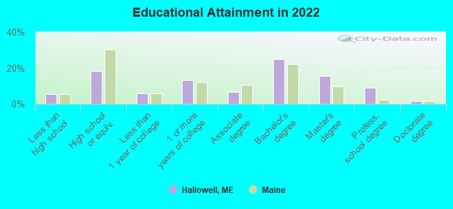
For population 25 years and over in Hallowell:
- High school or higher: 93.8%
- Bachelor's degree or higher: 50.1%
- Graduate or professional degree: 24.7%
- Unemployed: 4.5%
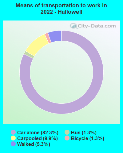
- Mean travel time to work (commute): 13.1 minutes
| Here: | 11.5 |
| Maine average: | 10.3 |


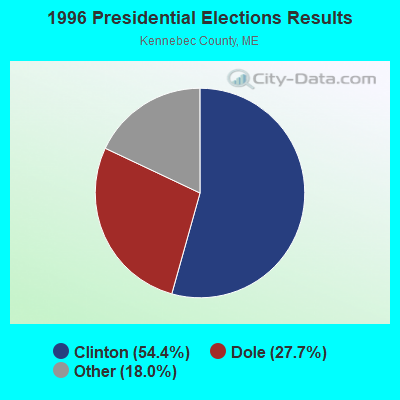
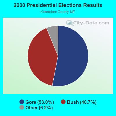


Graphs represent county-level data. Detailed 2008 Election Results
Religion statistics for Hallowell, ME (based on Kennebec County data)
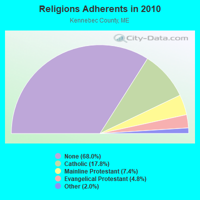
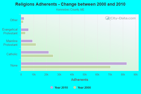
| Religion | Adherents | Congregations |
|---|---|---|
| Catholic | 21,758 | 11 |
| Mainline Protestant | 8,999 | 60 |
| Evangelical Protestant | 5,829 | 56 |
| Other | 2,466 | 17 |
| None | 83,099 | - |
Food Environment Statistics:
| Here: | 1.99 / 10,000 pop. |
| Maine: | 2.80 / 10,000 pop. |
| This county: | 0.17 / 10,000 pop. |
| State: | 0.14 / 10,000 pop. |
| This county: | 1.41 / 10,000 pop. |
| Maine: | 2.20 / 10,000 pop. |
| Kennebec County: | 6.38 / 10,000 pop. |
| State: | 5.75 / 10,000 pop. |
| Here: | 8.70 / 10,000 pop. |
| Maine: | 11.02 / 10,000 pop. |
| Kennebec County: | 8.6% |
| State: | 8.2% |
| Kennebec County: | 28.2% |
| Maine: | 25.0% |
Health and Nutrition:
| Hallowell: | 50.0% |
| Maine: | 53.9% |
| Here: | 46.0% |
| Maine: | 52.9% |
| This city: | 28.9 |
| Maine: | 28.3 |
| Hallowell: | 24.7% |
| Maine: | 19.9% |
| Here: | 5.4% |
| Maine: | 8.7% |
| Hallowell: | 6.7 |
| Maine: | 6.9 |
| This city: | 33.9% |
| Maine: | 34.3% |
| This city: | 57.4% |
| State: | 60.5% |
| Hallowell: | 75.8% |
| State: | 79.6% |
More about Health and Nutrition of Hallowell, ME Residents
| Local government employment and payroll (March 2022) | |||||
| Function | Full-time employees | Monthly full-time payroll | Average yearly full-time wage | Part-time employees | Monthly part-time payroll |
|---|---|---|---|---|---|
| Financial Administration | 7 | $13,610 | $23,331 | 0 | $0 |
| Streets and Highways | 4 | $17,008 | $51,024 | 0 | $0 |
| Police Protection - Officers | 4 | $22,570 | $67,710 | 0 | $0 |
| Totals for Government | 15 | $53,188 | $42,550 | 0 | $0 |
Hallowell government finances - Expenditure in 2017 (per resident):
- Construction - Regular Highways: $149,000 ($57.37)
General Public Buildings: $20,000 ($7.70)
Sewerage: $15,000 ($5.78)
- Current Operations - General - Other: $431,000 ($165.96)
Regular Highways: $427,000 ($164.42)
Police Protection: $337,000 ($129.77)
Central Staff Services: $262,000 ($100.89)
Financial Administration: $99,000 ($38.12)
Local Fire Protection: $87,000 ($33.50)
Solid Waste Management: $56,000 ($21.56)
Parks and Recreation: $38,000 ($14.63)
Libraries: $33,000 ($12.71)
Protective Inspection and Regulation - Other: $32,000 ($12.32)
Judicial and Legal Services: $32,000 ($12.32)
Miscellaneous Commercial Activities - Other: $27,000 ($10.40)
Public Welfare, Vendor Payments for Other Purposes: $13,000 ($5.01)
Natural Resources - Other: $7,000 ($2.70)
- General - Interest on Debt: $70,000 ($26.95)
- Intergovernmental to Local - Other - Health - Other: $26,000 ($10.01)
Other - Central Staff Services: $3,000 ($1.16)
- Other Capital Outlay - General - Other: $25,000 ($9.63)
Regular Highways: $5,000 ($1.93)
Parks and Recreation: $2,000 ($0.77)
- Total Salaries and Wages: $888,000 ($341.93)
Hallowell government finances - Revenue in 2017 (per resident):
- Charges - Other: $50,000 ($19.25)
Solid Waste Management: $27,000 ($10.40)
Parks and Recreation: $19,000 ($7.32)
Miscellaneous Commercial Activities: $4,000 ($1.54)
- Miscellaneous - Interest Earnings: $2,000 ($0.77)
- State Intergovernmental - General Local Government Support: $282,000 ($108.59)
Highways: $39,000 ($15.02)
Other: $12,000 ($4.62)
Public Welfare: $4,000 ($1.54)
- Tax - Property: $2,117,000 ($815.17)
Hallowell government finances - Debt in 2017 (per resident):
- Long Term Debt - Beginning Outstanding - Unspecified Public Purpose: $1,580,000 ($608.39)
Outstanding Unspecified Public Purpose: $986,000 ($379.67)
Retired Unspecified Public Purpose: $594,000 ($228.73)
Hallowell government finances - Cash and Securities in 2017 (per resident):
- Other Funds - Cash and Securities: $1,658,000 ($638.43)
Businesses in Hallowell, ME
- Dairy Queen: 1
- Ford: 1
Strongest AM radio stations in Hallowell:
- WFAU (1280 AM; 5 kW; GARDINER, ME; Owner: CAPSTAR TX LIMITED PARTNERSHIP)
- WEZW (1400 AM; 1 kW; AUGUSTA, ME; Owner: CITADEL BROADCASTING COMPANY)
- WMDR (1340 AM; 1 kW; AUGUSTA, ME; Owner: LIGHT OF LIFE MINISTRIES, INC.)
- WSKW (1160 AM; 10 kW; SKOWHEGAN, ME; Owner: MOUNTAIN WIRELESS, INCORPORATED)
- WTME (780 AM; 10 kW; RUMFORD, ME; Owner: MOUNTAIN VALLEY BROADCASTING, INC.)
- WLAM (1470 AM; 5 kW; LEWISTON, ME; Owner: RADIO PARTNERS OF MAINE, L.P.)
- WMTW (870 AM; 10 kW; GORHAM, ME; Owner: RADIO PARTNERS OF MAINE, L.P.)
- WGAN (560 AM; 5 kW; PORTLAND, ME; Owner: SAGA COMMUNICATIONS OF NEW ENGLAND, LLC)
- WRKO (680 AM; 50 kW; BOSTON, MA; Owner: ENTERCOM BOSTON LICENSE, LLC)
- WEEI (850 AM; 50 kW; BOSTON, MA; Owner: ENTERCOM BOSTON LICENSE, LLC)
- WBZ (1030 AM; 50 kW; BOSTON, MA; Owner: INFINITY BROADCASTING OPERATIONS, INC.)
- WZON (620 AM; 5 kW; BANGOR, ME; Owner: THE ZONE CORPORATION)
- WCRN (830 AM; 50 kW; WORCESTER, MA; Owner: CARTER BROADCASTING CORPORATION)
Strongest FM radio stations in Hallowell:
- WABK-FM (104.3 FM; GARDINER, ME; Owner: CAPSTAR TX LIMITED PARTNERSHIP)
- WKCG (101.3 FM; AUGUSTA, ME; Owner: CAPSTAR TX LIMITED PARTNERSHIP)
- WMME-FM (92.3 FM; AUGUSTA, ME; Owner: CITADEL BROADCASTING COMPANY)
- WCYI (93.9 FM; LEWISTON, ME; Owner: CITADEL BROADCASTING COMPANY)
- WWWA (95.3 FM; WINSLOW, ME; Owner: LIGHT OF LIFE MINISTRIES, INC.)
- WPKQ (103.7 FM; NORTH CONWAY, NH; Owner: CITADEL BROADCASTING COMPANY)
- WBCI (105.9 FM; BATH, ME; Owner: BLOUNT COMMUNICATIONS, INC.)
- WHOM (94.9 FM; MT. WASHINGTON, NH; Owner: CITADEL BROADCASTING COMPANY)
- WMEP (90.5 FM; CAMDEN, ME; Owner: MAINE PUBLIC BROADCASTING CORP.)
- WQSS (102.5 FM; CAMDEN, ME; Owner: CLEAR CHANNEL BROADCASTING LICENSES, INC.)
- WTOS-FM (105.1 FM; SKOWHEGAN, ME; Owner: CAPSTAR TX LIMITED PARTNERSHIP)
- WBLM (102.9 FM; PORTLAND, ME; Owner: CITADEL BROADCASTING COMPANY)
- WMEA (90.1 FM; PORTLAND, ME; Owner: MAINE PUBLIC BROADCASTING CORPORATION)
- WLOB-FM (96.3 FM; RUMFORD, ME; Owner: ATLANTIC COAST RADIO, LLC)
- WTHT (107.5 FM; LEWISTON, ME; Owner: RADIO PARTNERS OF MAINE, L.P.)
- WTBM (100.7 FM; MEXICO, ME; Owner: MOUNTAIN VALLEY BROADCASTING, INC.)
- WWBX (97.1 FM; BANGOR, ME; Owner: CLEAR CHANNEL BROADCASTING LICENSES, INC.)
- WMEW (91.3 FM; WATERVILLE, ME; Owner: MAINE PUBLIC BROADCASTING CORPORATION)
- WHQO (107.9 FM; SKOWHEGAN, ME; Owner: MOUNTAIN WIRELESS, INC.)
- WCME (96.7 FM; BOOTHBAY HARBOR, ME; Owner: CAPSTAR TX LIMITED PARTNERSHIP)
TV broadcast stations around Hallowell:
- WPFO (Channel 23; WATERVILLE, ME; Owner: CMCG PORTLAND LICENSE LLC)
- WCBB (Channel 10; AUGUSTA, ME; Owner: MAINE PUBLIC BROADCASTING CORP.)
- WGME-TV (Channel 13; PORTLAND, ME; Owner: WGME LICENSEE, LLC)
- WMTW-TV (Channel 8; POLAND SPRING, ME; Owner: WMTW BROADCAST GROUP, LLC)
- WFYW-LP (Channel 69; FAIRFIELD/WATERVILLE, ME; Owner: THREE ANGELS BROADCASTING NETWORK, INC.)
- DW23AB (Channel 23; WATERVILLE, ME; Owner: RUSSELL COMMUNICATIONS)
- National Bridge Inventory (NBI) Statistics
- 8Number of bridges
- 62ft / 18.6mTotal length
- 75,612Total average daily traffic
- 6,437Total average daily truck traffic
FCC Registered Antenna Towers:
24 (See the full list of FCC Registered Antenna Towers in Hallowell)FCC Registered Private Land Mobile Towers:
2 (See the full list of FCC Registered Private Land Mobile Towers in Hallowell, ME)FCC Registered Broadcast Land Mobile Towers:
8 (See the full list of FCC Registered Broadcast Land Mobile Towers)FCC Registered Microwave Towers:
5 (See the full list of FCC Registered Microwave Towers in this town)FCC Registered Paging Towers:
3 (See the full list of FCC Registered Paging Towers)FCC Registered Amateur Radio Licenses:
19 (See the full list of FCC Registered Amateur Radio Licenses in Hallowell)FAA Registered Aircraft:
1- Aircraft: PIPER PA-23-250 (Category: Land, Engines: 2, Seats: 6, Weight: Up to 12,499 Pounds, Speed: 150 mph), Engine: LYCOMING AEIO-540 SER (260 HP) (Reciprocating)
N-Number: 250BD, N250BD, N-250BD, Serial Number: 27-3082, Year manufactured: 1965, Airworthiness Date: 06/28/1984, Certificate Issue Date: 09/24/2020
Registrant (Individual): Marvin R Williams, 11 Vaughan Rd, Hallowell, ME 04347
2003 - 2018 National Fire Incident Reporting System (NFIRS) incidents
- Fire incident types reported to NFIRS in Hallowell, ME
- 7269.9%Structure Fires
- 2120.4%Outside Fires
- 87.8%Mobile Property/Vehicle Fires
- 21.9%Other
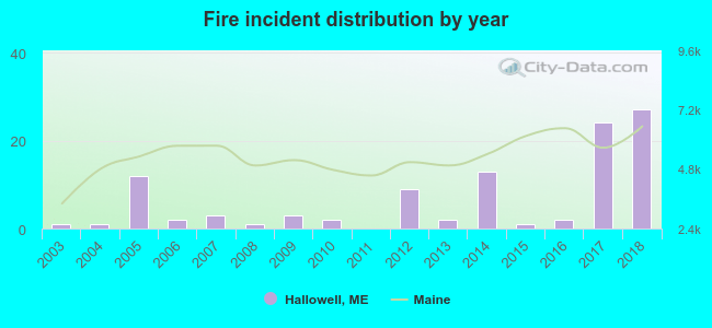 According to the data from the years 2003 - 2018 the average number of fires per year is 6. The highest number of fire incidents - 27 took place in 2018, and the least - 0 in 2011. The data has a rising trend.
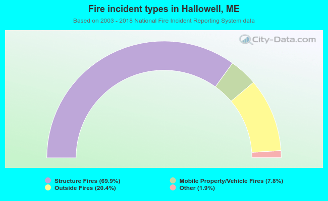 When looking into fire subcategories, the most incidents belonged to: Structure Fires (69.9%), and Outside Fires (20.4%).
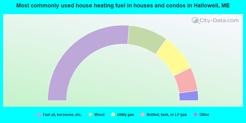
- 52.7%Fuel oil, kerosene, etc.
- 16.9%Wood
- 16.1%Utility gas
- 10.2%Bottled, tank, or LP gas
- 2.6%Other fuel
- 1.4%Electricity
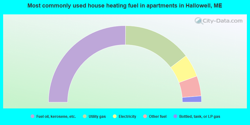
- 50.3%Fuel oil, kerosene, etc.
- 29.1%Utility gas
- 9.6%Electricity
- 8.5%Other fuel
- 2.6%Bottled, tank, or LP gas
Hallowell compared to Maine state average:
- Unemployed percentage below state average.
- Black race population percentage significantly below state average.
- Hispanic race population percentage significantly below state average.
- Median age above state average.
- Foreign-born population percentage below state average.
- Length of stay since moving in significantly above state average.
- House age above state average.
- Institutionalized population percentage above state average.
- Percentage of population with a bachelor's degree or higher above state average.

|
Total of 1 patent application in 2008-2024.