Grover, Wisconsin
Submit your own pictures of this town and show them to the world
- OSM Map
- Google Map
- MSN Map
Population change since 2000: +2.3%
| Males: 923 | |
| Females: 845 |
| Median resident age: | 42.0 years |
| Wisconsin median age: | 42.6 years |
| Grover: | $67,985 |
| WI: | $70,996 |
Estimated per capita income in 2022: $33,247 (it was $17,104 in 2000)
Grover town income, earnings, and wages data
Estimated median house or condo value in 2022: $195,157 (it was $88,000 in 2000)
| Grover: | $195,157 |
| WI: | $252,800 |
Detailed information about poverty and poor residents in Grover, WI


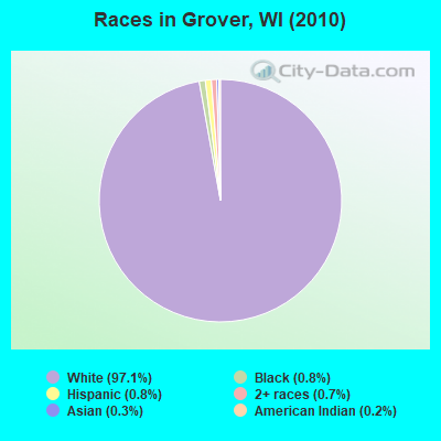
- 1,71797.1%White alone
- 150.8%Black alone
- 150.8%Hispanic
- 120.7%Two or more races
- 60.3%Asian alone
- 30.2%American Indian alone
Races in Grover detailed stats: ancestries, foreign born residents, place of birth
 Recent articles from our blog. Our writers, many of them Ph.D. graduates or candidates, create easy-to-read articles on a wide variety of topics.
Ancestries: German (49.6%), Polish (12.8%), United States (7.5%), French (7.0%), Irish (6.2%), Swedish (5.7%).
Current Local Time: CST time zone
Land area: 73.1 square miles.
Population density: 24 people per square mile (very low).
20 residents are foreign born
| This town: | 1.2% |
| Wisconsin: | 3.6% |
| Grover town: | 1.1% ($934) |
| Wisconsin: | 2.0% ($2,245) |
Nearest city with pop. 50,000+: Green Bay, WI  (39.0 miles , pop. 102,313).
Nearest city with pop. 200,000+: Milwaukee, WI (139.5 miles , pop. 596,974).
Nearest city with pop. 1,000,000+: Chicago, IL (223.5 miles , pop. 2,896,016).
Nearest cities:
), ), ), ), Latitude: 45.07 N, Longitude: 87.87 W
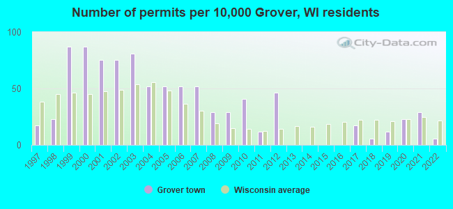
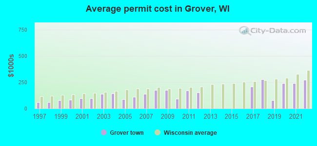
Single-family new house construction building permits:
- 2022: 1 building, cost: $273,300
- 2021: 5 buildings, average cost: $240,300
- 2020: 4 buildings, average cost: $240,300
- 2019: 2 buildings, average cost: $78,000
- 2018: 1 building, cost: $277,000
- 2017: 3 buildings, average cost: $206,700
- 2012: 8 buildings, average cost: $154,600
- 2011: 2 buildings, average cost: $170,000
- 2010: 7 buildings, average cost: $91,400
- 2009: 5 buildings, average cost: $174,000
- 2008: 5 buildings, average cost: $175,000
- 2007: 9 buildings, average cost: $141,300
- 2006: 9 buildings, average cost: $109,600
- 2005: 9 buildings, average cost: $89,600
- 2004: 9 buildings, average cost: $141,700
- 2003: 14 buildings, average cost: $137,800
- 2002: 13 buildings, average cost: $98,600
- 2001: 13 buildings, average cost: $98,600
- 2000: 15 buildings, average cost: $82,700
- 1999: 15 buildings, average cost: $79,800
- 1998: 4 buildings, average cost: $60,000
- 1997: 3 buildings, average cost: $60,000
| Here: | 4.0% |
| Wisconsin: | 2.7% |
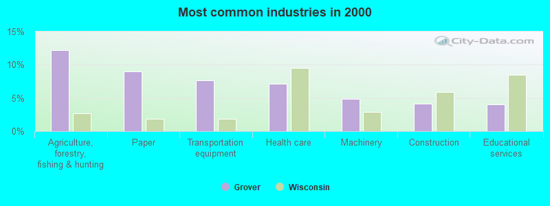
- Agriculture, forestry, fishing & hunting (12.2%)
- Paper (9.0%)
- Transportation equipment (7.7%)
- Health care (7.1%)
- Machinery (4.8%)
- Construction (4.1%)
- Educational services (4.0%)
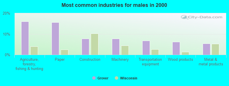
- Agriculture, forestry, fishing & hunting (16.0%)
- Paper (15.5%)
- Construction (7.7%)
- Machinery (7.7%)
- Transportation equipment (6.8%)
- Wood products (6.2%)
- Metal & metal products (5.3%)
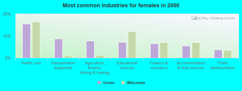
- Health care (15.5%)
- Transportation equipment (8.7%)
- Agriculture, forestry, fishing & hunting (7.7%)
- Educational services (7.2%)
- Finance & insurance (6.5%)
- Accommodation & food services (5.5%)
- Public administration (3.7%)
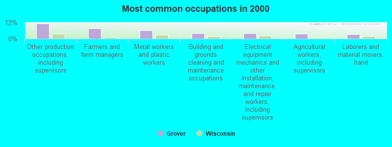
- Other production occupations, including supervisors (11.1%)
- Farmers and farm managers (7.8%)
- Metal workers and plastic workers (6.2%)
- Building and grounds cleaning and maintenance occupations (4.1%)
- Electrical equipment mechanics and other installation, maintenance, and repair workers, including supervisors (4.1%)
- Agricultural workers, including supervisors (3.7%)
- Laborers and material movers, hand (3.3%)
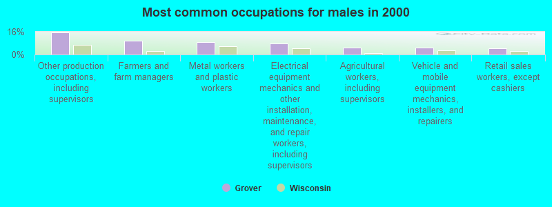
- Other production occupations, including supervisors (15.5%)
- Farmers and farm managers (9.8%)
- Metal workers and plastic workers (8.9%)
- Electrical equipment mechanics and other installation, maintenance, and repair workers, including supervisors (7.7%)
- Agricultural workers, including supervisors (4.9%)
- Vehicle and mobile equipment mechanics, installers, and repairers (4.9%)
- Retail sales workers, except cashiers (4.3%)
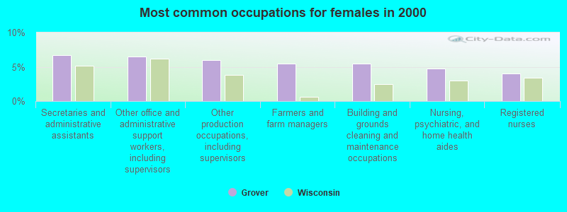
- Secretaries and administrative assistants (6.7%)
- Other office and administrative support workers, including supervisors (6.5%)
- Other production occupations, including supervisors (6.0%)
- Farmers and farm managers (5.5%)
- Building and grounds cleaning and maintenance occupations (5.5%)
- Nursing, psychiatric, and home health aides (4.7%)
- Registered nurses (4.0%)
Average climate in Grover, Wisconsin
Based on data reported by over 4,000 weather stations


Tornado activity:
Grover-area historical tornado activity is below Wisconsin state average. It is 41% smaller than the overall U.S. average.
On 8/19/1968, a category F4 (max. wind speeds 207-260 mph) tornado 10.1 miles away from the Grover town center killed 2 people and injured 3 people and caused between $500,000 and $5,000,000 in damages.
On 9/28/1971, a category F3 (max. wind speeds 158-206 mph) tornado 14.0 miles away from the town center caused between $50,000 and $500,000 in damages.
Earthquake activity:
Grover-area historical earthquake activity is above Wisconsin state average. It is 84% smaller than the overall U.S. average.On 5/2/2015 at 16:23:07, a magnitude 4.2 (4.2 MW, Depth: 2.8 mi, Class: Light, Intensity: IV - V) earthquake occurred 230.9 miles away from Grover center
On 6/28/2004 at 06:10:52, a magnitude 4.2 (4.2 MW, Depth: 6.2 mi) earthquake occurred 254.9 miles away from the city center
On 1/31/1986 at 16:46:43, a magnitude 5.0 (5.0 MB, Class: Moderate, Intensity: VI - VII) earthquake occurred 413.9 miles away from the city center
On 2/10/2010 at 09:59:35, a magnitude 3.8 (3.8 MW, Depth: 6.2 mi, Class: Light, Intensity: II - III) earthquake occurred 216.6 miles away from the city center
On 9/25/1998 at 19:52:52, a magnitude 5.2 (4.8 MB, 4.3 MS, 5.2 LG, 4.5 MW, Depth: 3.1 mi) earthquake occurred 450.2 miles away from Grover center
On 7/12/1986 at 08:19:37, a magnitude 4.5 (4.5 MB) earthquake occurred 360.2 miles away from the city center
Magnitude types: regional Lg-wave magnitude (LG), body-wave magnitude (MB), surface-wave magnitude (MS), moment magnitude (MW)
Natural disasters:
The number of natural disasters in Marinette County (6) is a lot smaller than the US average (15).Major Disasters (Presidential) Declared: 3
Emergencies Declared: 2
Causes of natural disasters: Floods: 3, Storms: 3, Drought: 1, Hurricane: 1, Tornado: 1, Wind: 1, Other: 1 (Note: some incidents may be assigned to more than one category).
Hospitals and medical centers near Grover:
- RENNES HEALTH AND REHAB CENTER-WEST (Nursing Home, about 6 miles away; PESHTIGO, WI)
- WHISPERING OAKS CARE CTR (Nursing Home, about 6 miles away; PESHTIGO, WI)
- RENNES HEALTH AND REHAB CENTER-EAST (Nursing Home, about 7 miles away; PESHTIGO, WI)
- DAVITA - MARINETTE DIALYSIS (Dialysis Facility, about 8 miles away; MARINETTE, WI)
- RESCARE HOME CARE WISCONSIN, INC (Home Health Center, about 12 miles away; MARINETTE, WI)
- BELLIN HEALTH OCONTO HOSPITAL Critical Access Hospitals (about 13 miles away; OCONTO, WI)
- BAY AREA MEDICAL CENTER (Dialysis Facility, about 13 miles away; MARINETTE, WI)
Colleges/universities with over 2000 students nearest to Grover:
- University of Wisconsin-Green Bay (about 38 miles; Green Bay, WI; Full-time enrollment: 5,415)
- Northeast Wisconsin Technical College (about 40 miles; Green Bay, WI; FT enrollment: 6,069)
- Saint Norbert College (about 45 miles; De Pere, WI; FT enrollment: 2,324)
- Fox Valley Technical College (about 62 miles; Appleton, WI; FT enrollment: 5,682)
- Lawrence University (about 62 miles; Appleton, WI; FT enrollment: 2,821)
- University of Wisconsin-Oshkosh (about 80 miles; Oshkosh, WI; FT enrollment: 10,637)
- Lakeland College (about 85 miles; Plymouth, WI; FT enrollment: 2,395)
Points of interest:
Notable location: Grover - Porterfield Fire Department (A). Display/hide its location on the map
Church in Grover: Saint Johns Church (A). Display/hide its location on the map
Cemetery: Harmony Cemetery (1). Display/hide its location on the map
Rivers and creeks: Little Peshtigo River (A), Bundy Creek (B). Display/hide their locations on the map
Birthplace of: Lefty Gervais - Major League Baseball pitcher.
| This town: | 2.6 people |
| Wisconsin: | 2.4 people |
| This town: | 73.7% |
| Whole state: | 64.4% |
| This town: | 6.1% |
| Whole state: | 7.3% |
Likely homosexual households (counted as self-reported same-sex unmarried-partner households)
- Lesbian couples: 0.1% of all households
- Gay men: 0.3% of all households
| This town: | 7.9% |
| Whole state: | 8.7% |
| This town: | 2.4% |
| Whole state: | 3.7% |
For population 15 years and over in Grover:
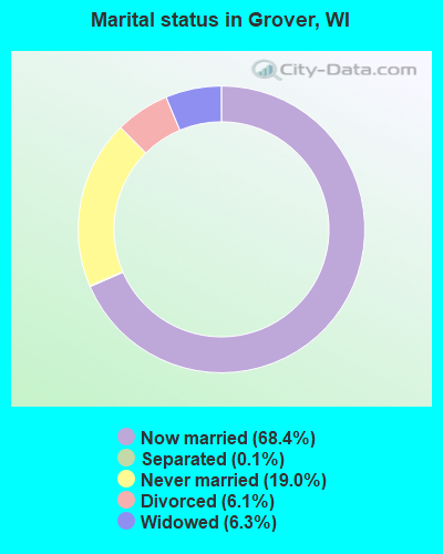
- Never married: 19.0%
- Now married: 68.4%
- Separated: 0.1%
- Widowed: 6.3%
- Divorced: 6.1%
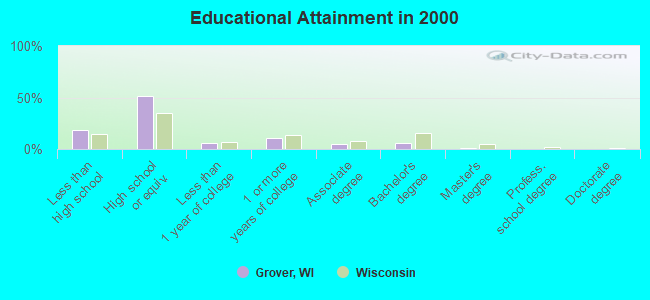
For population 25 years and over in Grover:
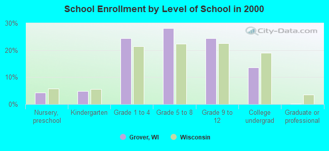
- High school or higher: 81.2%
- Bachelor's degree or higher: 7.3%
- Graduate or professional degree: 1.5%
- Unemployed: 5.0%
- Mean travel time to work (commute): 22.2 minutes
| Here: | 9.0 |
| Wisconsin average: | 11.0 |
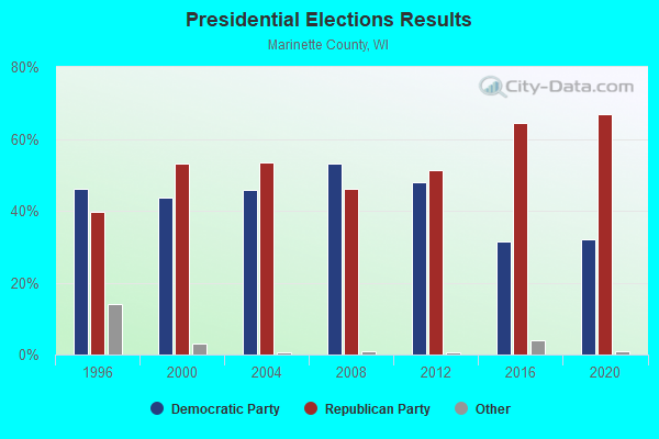
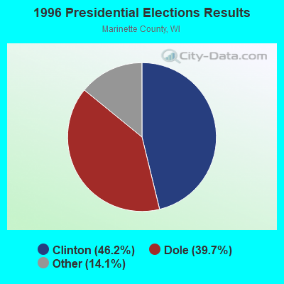
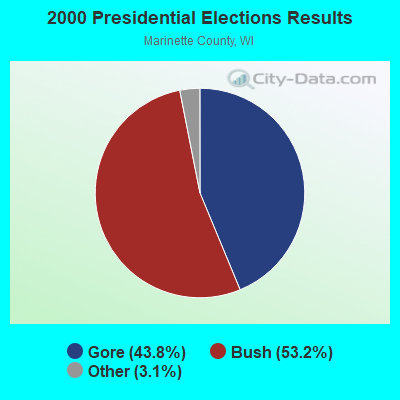
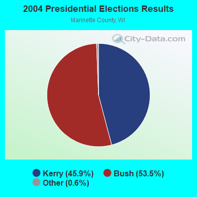
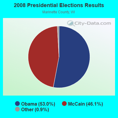
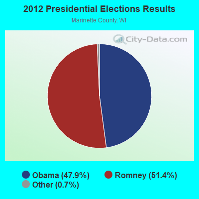
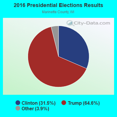
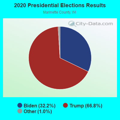
Graphs represent county-level data. Detailed 2008 Election Results
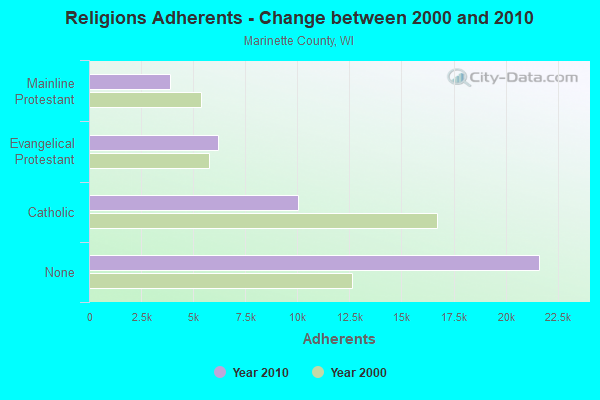
Religion statistics for Grover, WI (based on Marinette County data)
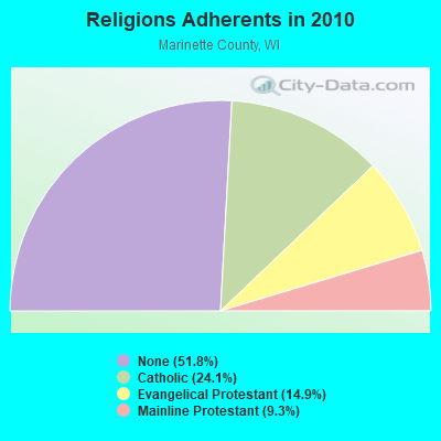
| Religion | Adherents | Congregations |
|---|---|---|
| Catholic | 10,053 | 10 |
| Evangelical Protestant | 6,205 | 33 |
| Mainline Protestant | 3,866 | 20 |
| Other | 1 | 4 |
| None | 21,624 | - |
Food Environment Statistics:
| Marinette County: | 2.83 / 10,000 pop. |
| Wisconsin: | 1.86 / 10,000 pop. |
| Marinette County: | 0.24 / 10,000 pop. |
| State: | 0.38 / 10,000 pop. |
| Marinette County: | 7.54 / 10,000 pop. |
| Wisconsin: | 4.12 / 10,000 pop. |
| This county: | 11.78 / 10,000 pop. |
| Wisconsin: | 8.64 / 10,000 pop. |
| Here: | 7.9% |
| State: | 7.6% |
| Marinette County: | 29.0% |
| Wisconsin: | 27.5% |
| This county: | 7.1% |
| Wisconsin: | 13.0% |
Strongest AM radio stations in Grover:
- WNAM (1280 AM; 50 kW; NEENAH-MENASHA, WI; Owner: CUMULUS LICENSING CORP.)
- WSPT (1010 AM; 50 kW; STEVENS POINT, WI)
- WOCO (1260 AM; 1 kW; OCONTO, WI; Owner: LAMARDO INC.)
- WTCM (580 AM; 35 kW; TRAVERSE CITY, MI; Owner: WTCM RADIO, INC.)
- WSAU (550 AM; 20 kW; WAUSAU, WI; Owner: WRIG, INC.)
- WAGN (1340 AM; 1 kW; MENOMINEE, MI; Owner: BADGER COMMUNICATIONS, L.L.C.)
- WHBY (1150 AM; 25 kW; KIMBERLY, WI; Owner: WOODWARD COMMUNICATIONS, INC.)
- WDBC (680 AM; 10 kW; ESCANABA, MI; Owner: KMB BROADCASTING, INC.)
- WTAQ (1360 AM; 10 kW; GREEN BAY, WI; Owner: MIDWEST COMMUNICATIONS, INC.)
- WLDR (1210 AM; daytime; 50 kW; KINGSLEY, MI; Owner: FORT BEND BROADCASTING COMPANY)
- WTMJ (620 AM; 50 kW; MILWAUKEE, WI; Owner: JOURNAL BROADCAST CORPORATION)
- WMAM (570 AM; 0 kW; MARINETTE, WI; Owner: BADGER COMMUNICATIONS L.L.C.)
- WNFL (1440 AM; 5 kW; GREEN BAY, WI; Owner: MIDWEST COMMUNICATIONS, INC.)
Strongest FM radio stations in Grover:
- WSFQ (96.3 FM; PESHTIGO, WI; Owner: BADGER COMMUNICATIONS, L.L.C.)
- WLST (95.1 FM; MARINETTE, WI; Owner: BADGER COMMUNICATIONS L.L.C.)
- WHYB (103.7 FM; MENOMINEE, MI; Owner: BADGER COMMUNICATIONS, L.L.C.)
- WRVM (102.7 FM; SURING, WI; Owner: WRVM, INC.)
- WPFF (90.5 FM; STURGEON BAY, WI; Owner: FAMILY ED BC CORP OF DOOR COUNTY WI)
- WDOR-FM (93.9 FM; STURGEON BAY, WI; Owner: DOOR COUNTY BROADCASTING CO., INC.)
- WSRG (97.7 FM; STURGEON BAY, WI; Owner: MAGNUM BROADCASTING, INC.)
- WOCO-FM (107.1 FM; OCONTO, WI; Owner: LAMARDO INC.)
- WIXX (101.1 FM; GREEN BAY, WI; Owner: MIDWEST COMMUNICATIONS, INC.)
- WRGX (88.5 FM; STURGEON BAY, WI; Owner: FAMILY ED B/C CORP OF DOOR COUNTY WI)
- WMXG (106.3 FM; STEPHENSON, MI; Owner: ESCANABA LICENSE CORP.)
- WLYD (99.7 FM; STURGEON BAY, WI; Owner: MIDWEST COMMUNICATIONS INC)
- WEMY (91.5 FM; GREEN BAY, WI; Owner: EVANGEL MINISTRIES, INC)
- WBDK (96.7 FM; ALGOMA, WI; Owner: NICOLET BROADCASTING, INC.)
TV broadcast stations around Grover:
- WIWB (Channel 14; SURING, WI; Owner: ACME TV LICENSES OF WISCONSIN, LLC)
- WBAY-TV (Channel 2; GREEN BAY, WI; Owner: YOUNG BROADCASTING OF GREEN BAY, INC.)
- WPNE (Channel 38; GREEN BAY, WI; Owner: WISCONSIN EDUCATIONAL COMMUNICATIONS BOARD)
- W22BW (Channel 22; STURGEON BAY, WI; Owner: ARIES TELECOMMUNICATION CORPORATION)
- National Bridge Inventory (NBI) Statistics
- 8Number of bridges
- 26ft / 8.4mTotal length
- 16,372Total average daily traffic
- 155Total average daily truck traffic
- 23,258Total future (year 2039) average daily traffic
FCC Registered Antenna Towers:
11 (See the full list of FCC Registered Antenna Towers in Grover)FCC Registered Microwave Towers:
3- HARMONY, Jct Bridge Rd & Gross Ln (Lat: 45.121917 Lon: -87.852056), Type: Gtower, Structure height: 153 m, Overall height: 158.8 m, Call Sign: WQPF285,
Assigned Frequencies: 6226.89 MHz, 6345.49 MHz, Grant Date: 06/14/2022, Expiration Date: 04/30/2032, Certifier: Mark Naze, Registrant: Lukas, Lafuria, Lantor & Sachs, LLP, 8350 Broad Street, Suite 1450, Tysons, VA 22102, Phone: (703) 584-8673, Fax: (920) 617-5744, Email:
- ML93716A, Jct Bridge Rd & Gross Ln (Lat: 45.123361 Lon: -87.852639), Type: Gtower, Structure height: 153 m, Overall height: 158.8 m, Call Sign: WRDV618,
Assigned Frequencies: 10935.0 MHz, 10935.0 MHz, 10935.0 MHz, 10935.0 MHz, 10935.0 MHz, 10935.0 MHz, 10935.0 MHz, 10935.0 MHz, 10935.0 MHz, 10935.0 MHz, Grant Date: 07/30/2019, Expiration Date: 07/30/2029, Cancellation Date: 01/25/2021, Certifier: David Werblow, Registrant: T-Mobile Usa, Inc., 12920 Se 38th Street, Bellevue, WA 98006, Phone: (425) 383-8401, Fax: (425) 383-4040, Email:
- ML93716A, Jct Bridge Rd & Gross Ln (Lat: 45.123361 Lon: -87.852611), Type: Gtower, Structure height: 153 m, Overall height: 158.8 m, Call Sign: WRNC304,
Assigned Frequencies: 10935.0 MHz, 10935.0 MHz, 10935.0 MHz, 10935.0 MHz, 10935.0 MHz, 10935.0 MHz, 10935.0 MHz, 10935.0 MHz, 10935.0 MHz, 10935.0 MHz, Grant Date: 07/13/2021, Expiration Date: 07/13/2031, Certifier: David Werblow, Registrant: T-Mobile Usa, Inc., 12920 Se 38th Street, Bellevue, WA 98006, Phone: (425) 383-8401, Fax: (425) 383-4040, Email:
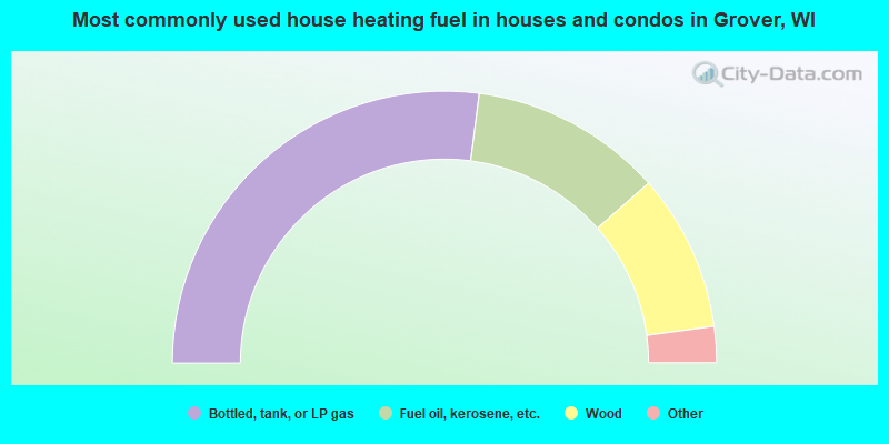
- 54.1%Bottled, tank, or LP gas
- 22.9%Fuel oil, kerosene, etc.
- 18.7%Wood
- 1.9%Electricity
- 1.7%Utility gas
- 0.7%Other fuel
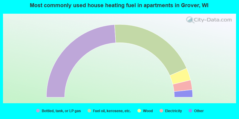
- 47.8%Bottled, tank, or LP gas
- 39.1%Fuel oil, kerosene, etc.
- 5.4%Wood
- 4.3%Electricity
- 2.2%Other fuel
- 1.1%Utility gas
Grover compared to Wisconsin state average:
- Unemployed percentage below state average.
- Black race population percentage significantly below state average.
- Hispanic race population percentage significantly below state average.
- Foreign-born population percentage significantly below state average.
- Renting percentage significantly below state average.
- Length of stay since moving in significantly above state average.
- Number of rooms per house significantly below state average.
- House age significantly below state average.
- Percentage of population with a bachelor's degree or higher significantly below state average.