Groton, South Dakota
Submit your own pictures of this city and show them to the world
(2.4% for White Non-Hispanic residents, 12.2% for Hispanic or Latino residents, 37.5% for two or more races residents)
Detailed information about poverty and poor residents in Groton, SD
Full-time law enforcement employees in 2021, including police officers: 4 (4 officers - 4 male; 0 female).
| Officers per 1,000 residents here: | 2.71 |
| South Dakota average: | 2.20 |
 Recent articles from our blog. Our writers, many of them Ph.D. graduates or candidates, create easy-to-read articles on a wide variety of topics.
| Here: | 1.9% |
| South Dakota: | 2.0% |
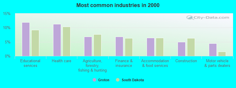
- Educational services (11.9%)
- Health care (11.3%)
- Agriculture, forestry, fishing & hunting (6.8%)
- Finance & insurance (6.8%)
- Accommodation & food services (6.4%)
- Construction (4.9%)
- Motor vehicle & parts dealers (4.5%)
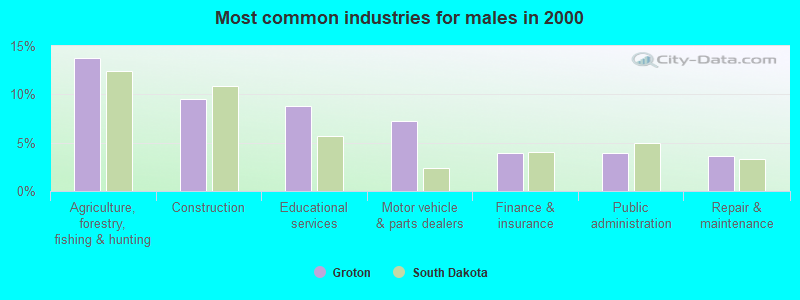
- Agriculture, forestry, fishing & hunting (13.7%)
- Construction (9.5%)
- Educational services (8.8%)
- Motor vehicle & parts dealers (7.2%)
- Finance & insurance (3.9%)
- Public administration (3.9%)
- Repair & maintenance (3.6%)
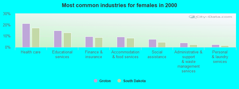
- Health care (21.1%)
- Educational services (14.9%)
- Finance & insurance (9.6%)
- Accommodation & food services (9.3%)
- Social assistance (7.1%)
- Administrative & support & waste management services (4.0%)
- Personal & laundry services (2.5%)
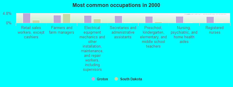
- Retail sales workers, except cashiers (4.8%)
- Farmers and farm managers (4.0%)
- Electrical equipment mechanics and other installation, maintenance, and repair workers, including supervisors (3.8%)
- Secretaries and administrative assistants (3.7%)
- Preschool, kindergarten, elementary, and middle school teachers (3.3%)
- Nursing, psychiatric, and home health aides (3.3%)
- Registered nurses (3.2%)
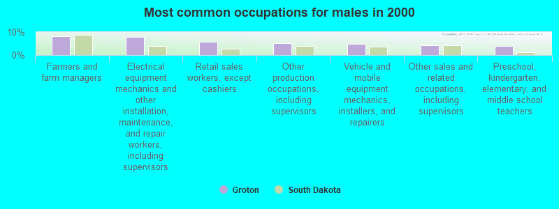
- Farmers and farm managers (8.2%)
- Electrical equipment mechanics and other installation, maintenance, and repair workers, including supervisors (7.8%)
- Retail sales workers, except cashiers (5.9%)
- Other production occupations, including supervisors (5.2%)
- Vehicle and mobile equipment mechanics, installers, and repairers (4.9%)
- Other sales and related occupations, including supervisors (4.2%)
- Preschool, kindergarten, elementary, and middle school teachers (3.9%)
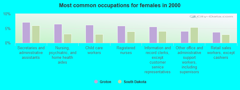
- Secretaries and administrative assistants (7.1%)
- Nursing, psychiatric, and home health aides (6.5%)
- Child care workers (6.2%)
- Registered nurses (5.9%)
- Information and record clerks, except customer service representatives (5.6%)
- Other office and administrative support workers, including supervisors (4.0%)
- Retail sales workers, except cashiers (3.7%)
Average climate in Groton, South Dakota
Based on data reported by over 4,000 weather stations


|
|

(lower is better)
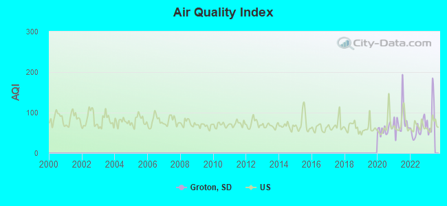
Air Quality Index (AQI) level in 2022 was 57.9. This is better than average.
| City: | 57.9 |
| U.S.: | 72.6 |
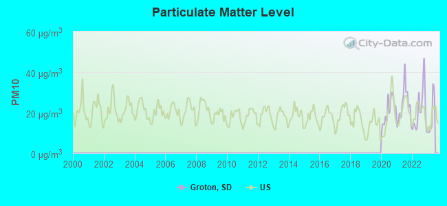
Particulate Matter (PM10) [µg/m3] level in 2022 was 21.1. This is about average. Closest monitor was 18.7 miles away from the city center.
| City: | 21.1 |
| U.S.: | 19.2 |
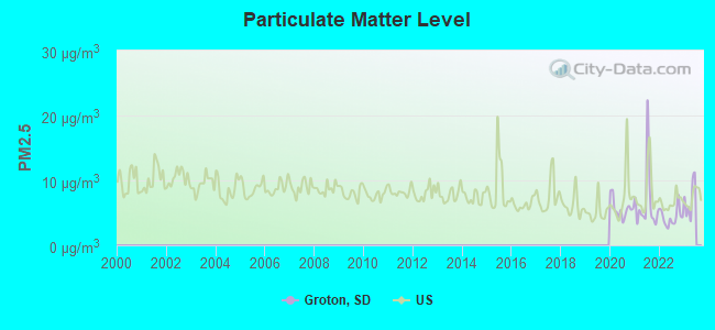
Particulate Matter (PM2.5) [µg/m3] level in 2022 was 4.35. This is significantly better than average. Closest monitor was 18.8 miles away from the city center.
| City: | 4.35 |
| U.S.: | 8.11 |
Tornado activity:
Groton-area historical tornado activity is slightly below South Dakota state average. It is 10% smaller than the overall U.S. average.
On 6/23/2002, a category F4 (max. wind speeds 207-260 mph) tornado 22.5 miles away from the Groton city center .
On 6/25/1969, a category F3 (max. wind speeds 158-206 mph) tornado 0.9 miles away from the city center injured 6 people and caused between $50,000 and $500,000 in damages.
Earthquake activity:
Groton-area historical earthquake activity is significantly above South Dakota state average. It is 11% greater than the overall U.S. average.On 8/18/1959 at 06:37:13, a magnitude 7.7 (7.7 UK, Class: Major, Intensity: VIII - XII) earthquake occurred 616.4 miles away from Groton center, causing $26,000,000 total damage
On 7/9/1975 at 14:54:15, a magnitude 4.6 (4.6 MB, Class: Light, Intensity: IV - V) earthquake occurred 100.8 miles away from the city center
On 3/4/1983 at 06:32:18, a magnitude 4.6 (4.4 MB, 4.6 LG, 4.4 ML) earthquake occurred 107.0 miles away from Groton center
On 6/5/1993 at 01:24:53, a magnitude 4.1 (4.1 LG, Depth: 6.2 mi) earthquake occurred 88.8 miles away from Groton center
On 10/20/1995 at 15:57:18, a magnitude 3.7 (3.7 LG, Depth: 3.1 mi, Class: Light, Intensity: II - III) earthquake occurred 64.1 miles away from the city center
On 11/3/2002 at 20:41:56, a magnitude 4.3 (4.3 MB, Depth: 3.1 mi) earthquake occurred 189.7 miles away from Groton center
Magnitude types: regional Lg-wave magnitude (LG), body-wave magnitude (MB), local magnitude (ML)
Natural disasters:
The number of natural disasters in Brown County (17) is near the US average (15).Major Disasters (Presidential) Declared: 13
Emergencies Declared: 2
Causes of natural disasters: Floods: 11, Storms: 8, Tornadoes: 3, Winter Storms: 3, Blizzard: 1, Drought: 1, Hurricane: 1, Snowstorm: 1, Other: 1 (Note: some incidents may be assigned to more than one category).

Hospitals and medical centers in Groton:
Airports located in Groton:
- Groton Municipal Airport (2E6) (Runways: 1, Local Ops: 60)
Colleges/universities with over 2000 students nearest to Groton:
- Northern State University (about 19 miles; Aberdeen, SD; Full-time enrollment: 2,203)
- North Dakota State College of Science (about 92 miles; Wahpeton, ND; FT enrollment: 2,318)
- South Dakota State University (about 102 miles; Brookings, SD; FT enrollment: 10,392)
- Minnesota State Community and Technical College (about 113 miles; Fergus Falls, MN; FT enrollment: 4,863)
- Concordia College at Moorhead (about 117 miles; Moorhead, MN; FT enrollment: 2,767)
- Minnesota State University-Moorhead (about 117 miles; Moorhead, MN; FT enrollment: 6,096)
- North Dakota State University-Main Campus (about 118 miles; Fargo, ND; FT enrollment: 12,680)
Public high school in Groton:
- GROTON AREA HIGH SCHOOL - 01 (Location: 406 N 2ND STREET, Grades: 9-12)
Public elementary/middle schools in Groton:
- GROTON AREA ELEMENTARY - 02 (Location: 810 N 1ST ST, Grades: PK-5)
- GROTON AREA MS - 04 (Location: 406 N 2ND STREET, Grades: 6-8)
Points of interest:
Notable locations in Groton: Groton Community Fire Department (A), Groton City Hall (B), Wage Memorial Library (C). Display/hide their locations on the map
Cemetery: Groton Cemetery (1). Display/hide its location on the map
Birthplace of: Earl Sande - Jockey.
Drinking water stations with addresses in Groton that have no violations reported:
- GROTON (Population served: 1,458, Primary Water Source Type: Purch surface water)
| This city: | 2.5 people |
| South Dakota: | 2.4 people |
| This city: | 64.8% |
| Whole state: | 64.2% |
| This city: | 4.5% |
| Whole state: | 6.5% |
Likely homosexual households (counted as self-reported same-sex unmarried-partner households)
- Lesbian couples: 0.0% of all households
- Gay men: 0.3% of all households
71 people in nursing homes in 2000
Banks with branches in Groton (2011 data):
- First State Bank of Claremont: First State Bank Of Claremont at 7 East Highway 12, branch established on 1903/01/01. Info updated 2008/07/23: Bank assets: $51.0 mil, Deposits: $43.8 mil, local headquarters, positive income, Agricultural Specialization, 4 total offices
- Wells Fargo Bank, National Association: Groton Branch at 120 North Main Street, branch established on 1935/04/01. Info updated 2011/04/05: Bank assets: $1,161,490.0 mil, Deposits: $905,653.0 mil, headquarters in Sioux Falls, SD, positive income, 6395 total offices, Holding Company: Wells Fargo & Company
| Here: | 9.5 |
| South Dakota average: | 10.5 |
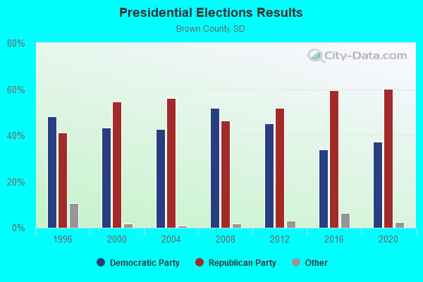
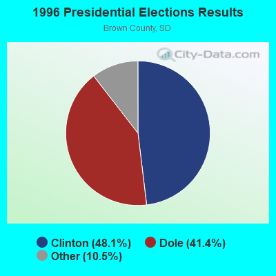
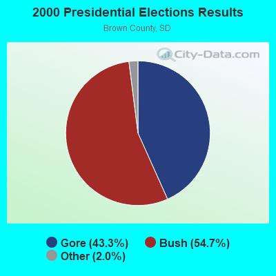
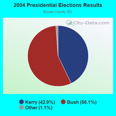
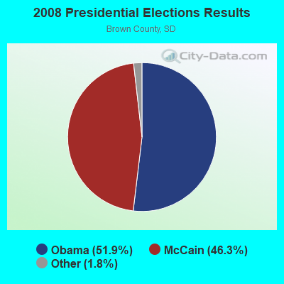
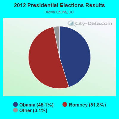
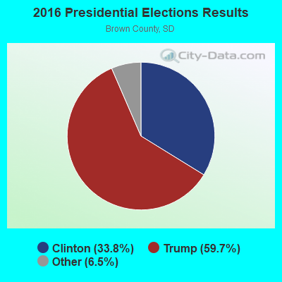
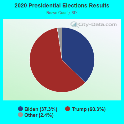
Graphs represent county-level data. Detailed 2008 Election Results
Religion statistics for Groton, SD (based on Brown County data)
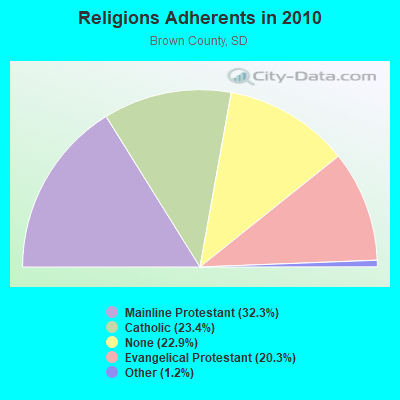
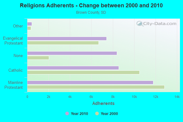
| Religion | Adherents | Congregations |
|---|---|---|
| Mainline Protestant | 11,782 | 24 |
| Catholic | 8,543 | 6 |
| Evangelical Protestant | 7,400 | 41 |
| Other | 426 | 3 |
| None | 8,380 | - |
Food Environment Statistics:
| Brown County: | 1.71 / 10,000 pop. |
| South Dakota: | 2.84 / 10,000 pop. |
| Brown County: | 0.85 / 10,000 pop. |
| State: | 0.65 / 10,000 pop. |
| Brown County: | 4.55 / 10,000 pop. |
| South Dakota: | 6.68 / 10,000 pop. |
| This county: | 6.83 / 10,000 pop. |
| South Dakota: | 9.21 / 10,000 pop. |
| Brown County: | 7.0% |
| South Dakota: | 7.7% |
| This county: | 27.6% |
| South Dakota: | 27.7% |
| Brown County: | 16.7% |
| State: | 14.9% |
Health and Nutrition:
| Groton: | 51.9% |
| South Dakota: | 51.4% |
| Groton: | 48.4% |
| South Dakota: | 49.4% |
| Groton: | 29.3 |
| State: | 28.5 |
| This city: | 21.2% |
| State: | 20.6% |
| Groton: | 13.5% |
| State: | 9.7% |
| Groton: | 6.8 |
| South Dakota: | 6.9 |
| This city: | 37.4% |
| South Dakota: | 34.1% |
| This city: | 56.6% |
| South Dakota: | 58.1% |
| This city: | 76.3% |
| South Dakota: | 78.7% |
More about Health and Nutrition of Groton, SD Residents
| Local government employment and payroll (March 2022) | |||||
| Function | Full-time employees | Monthly full-time payroll | Average yearly full-time wage | Part-time employees | Monthly part-time payroll |
|---|---|---|---|---|---|
| Police Protection - Officers | 3 | $20,936 | $83,744 | 0 | $0 |
| Financial Administration | 3 | $12,575 | $50,300 | 0 | $0 |
| Electric Power | 2 | $6,666 | $39,996 | 0 | $0 |
| Streets and Highways | 1 | $5,040 | $60,480 | 0 | $0 |
| Sewerage | 1 | $4,967 | $59,604 | 0 | $0 |
| Water Supply | 1 | $6,028 | $72,336 | 0 | $0 |
| Solid Waste Management | 1 | $4,855 | $58,260 | 0 | $0 |
| Totals for Government | 12 | $61,068 | $61,068 | 0 | $0 |
Groton government finances - Expenditure in 2021 (per resident):
- Construction - Sewerage: $20,000 ($14.53)
Electric Utilities: $18,000 ($13.08)
Regular Highways: $16,000 ($11.63)
- Current Operations - General - Other: $391,000 ($284.16)
Regular Highways: $221,000 ($160.61)
Water Utilities: $219,000 ($159.16)
Parks and Recreation: $205,000 ($148.98)
Financial Administration: $201,000 ($146.08)
Electric Utilities: $201,000 ($146.08)
Police Protection: $136,000 ($98.84)
Central Staff Services: $134,000 ($97.38)
Solid Waste Management: $104,000 ($75.58)
Sewerage: $84,000 ($61.05)
Air Transportation: $30,000 ($21.80)
General Public Buildings: $18,000 ($13.08)
Judicial and Legal Services: $14,000 ($10.17)
Housing and Community Development: $12,000 ($8.72)
Miscellaneous Commercial Activities - Other: $12,000 ($8.72)
Libraries: $9,000 ($6.54)
Natural Resources - Other: $9,000 ($6.54)
Health - Other: $4,000 ($2.91)
Transit Utilities: $3,000 ($2.18)
- General - Interest on Debt: $107,000 ($77.76)
- Other Capital Outlay - Water Utilities: $844,000 ($613.37)
- Total Salaries and Wages: $899,000 ($653.34)
Groton government finances - Revenue in 2021 (per resident):
- Charges - Sewerage: $209,000 ($151.89)
Solid Waste Management: $115,000 ($83.58)
Parks and Recreation: $61,000 ($44.33)
Other: $17,000 ($12.35)
Miscellaneous Commercial Activities: $12,000 ($8.72)
Regular Highways: $3,000 ($2.18)
- Federal Intergovernmental - Other: $280,000 ($203.49)
Natural Resources: $23,000 ($16.72)
- Local Intergovernmental - Highways: $2,000 ($1.45)
Other: $1,000 ($0.73)
- Miscellaneous - Special Assessments: $56,000 ($40.70)
Donations From Private Sources: $45,000 ($32.70)
Rents: $20,000 ($14.53)
Fines and Forfeits: $1,000 ($0.73)
- Revenue - Electric Utilities: $1,760,000 ($1279.07)
Water Utilities: $443,000 ($321.95)
- State Intergovernmental - Highways: $51,000 ($37.06)
General Local Government Support: $19,000 ($13.81)
Other: $11,000 ($7.99)
- Tax - Property: $659,000 ($478.92)
General Sales and Gross Receipts: $591,000 ($429.51)
Other Selective Sales: $28,000 ($20.35)
Other License: $15,000 ($10.90)
Alcoholic Beverage License: $7,000 ($5.09)
Amusements License: $1,000 ($0.73)
Groton government finances - Debt in 2021 (per resident):
- Long Term Debt - Beginning Outstanding - Unspecified Public Purpose: $2,673,000 ($1942.59)
Outstanding Unspecified Public Purpose: $2,529,000 ($1837.94)
Retired Unspecified Public Purpose: $145,000 ($105.38)
Groton government finances - Cash and Securities in 2021 (per resident):
- Other Funds - Cash and Securities: $1,674,000 ($1216.57)
Businesses in Groton, SD
- Dairy Queen: 1
- Ford: 1
- Subway: 1
Strongest AM radio stations in Groton:
- KKAA (1560 AM; 10 kW; ABERDEEN, SD; Owner: CLEAR CHANNEL BROADCASTING LICENSES, INC.)
- KSDN (930 AM; 5 kW; ABERDEEN, SD; Owner: CLEAR CHANNEL BROADCASTING LICENSES, INC.)
- KXMR (710 AM; 50 kW; BISMARCK, ND; Owner: RADIO BISMARCK MANDAN, LLC)
- KGIM (1420 AM; 1 kW; ABERDEEN, SD; Owner: PHEASANT COUNTRY BROADCASTING, INC.)
- WWNL (1080 AM; 50 kW; PITTSBURGH, PA; Owner: STEEL CITY RADIO, INC.)
- WCCO (830 AM; 50 kW; MINNEAPOLIS, MN; Owner: INFINITY MEDIA CORPORATION)
- WEBC (560 AM; 50 kW; DULUTH, MN)
- KPRM (870 AM; 25 kW; PARK RAPIDS, MN; Owner: DE LA HUNT BROADCASTING CORP.)
- KSJB (600 AM; 5 kW; JAMESTOWN, ND; Owner: CHESTERMAN COMM. JAMESTOWN, INC.)
- KFAN (1130 AM; 50 kW; MINNEAPOLIS, MN; Owner: AMFM RADIO LICENSES, L.L.C.)
- KOKK (1210 AM; 5 kW; HURON, SD; Owner: DAKOTA COMMUNICATIONS, LTD.)
- WCTS (1030 AM; 50 kW; MAPLEWOOD, MN; Owner: CNTL. BAPT. THEO/AL SEMI MINNEAPOLIS)
- KFNW (1200 AM; 10 kW; WEST FARGO, ND; Owner: NORTHWESTERN COLLEGE)
Strongest FM radio stations in Groton:
- KDSD-FM (90.9 FM; PIERPONT, SD; Owner: SOUTH DAKOTA BOARD OF DIRECTORS FOR ED. TELECOMMUNICATIONS)
- KBFO (106.7 FM; ABERDEEN, SD; Owner: CLEAR CHANNEL BROADCASTING LICENSES, INC.)
- KDLO-FM (96.9 FM; WATERTOWN, SD; Owner: SORENSON BROADCASTING CORPORATION)
- KSDN-FM (94.1 FM; ABERDEEN, SD; Owner: CLEAR CHANNEL BROADCASTING LICENSES, INC.)
- K253AB (98.5 FM; ABERDEEN, SD; Owner: CHRISTIAN HERITAGE BROADCASTING, INC.)
- KGIM-FM (103.7 FM; REDFIELD, SD; Owner: PHEASANT COUNTRY BROADCASTING, INC.)
- KQAA (94.9 FM; ABERDEEN, SD; Owner: CLEAR CHANNEL BROADCASTING LICENSES, INC.)
- KNBZ (97.7 FM; REDFIELD, SD; Owner: PHEASANT COUNTRY BROADCASTING, INC.)
TV broadcast stations around Groton:
- KABY-TV (Channel 9; ABERDEEN, SD; Owner: ELCOM OF SOUTH DAKOTA, INC.)
- KDSD-TV (Channel 16; ABERDEEN, SD; Owner: SOUTH DAKOTA BOARD OF DIRECTORS FOR ED. TELECOMMUNICATIONS)
- KDLO-TV (Channel 3; FLORENCE, SD; Owner: YOUNG BROADCASTING OF SIOUX FALLS, INC.)
- K35FJ (Channel 35; ABERDEEN, SD; Owner: TRINITY BROADCASTING NETWORK)
- K24DT (Channel 24; ABERDEEN, SD; Owner: YOUNG BROADCASTING OF SIOUX FALLS, INC.)
Groton fatal accident list:
Nov 29, 1991 04:20 PM, 12, Vehicles: 2, Persons: 3, Fatalities: 1
Aug 25, 1983 02:18 PM, 4th Ave, Vehicles: 1, Persons: 2, Fatalities: 1
- National Bridge Inventory (NBI) Statistics
- 17Number of bridges
- 184ft / 56.3mTotal length
- $2,166,000Total costs
- 17,377Total average daily traffic
- 2,768Total average daily truck traffic
- 22,133Total future (year 2032) average daily traffic
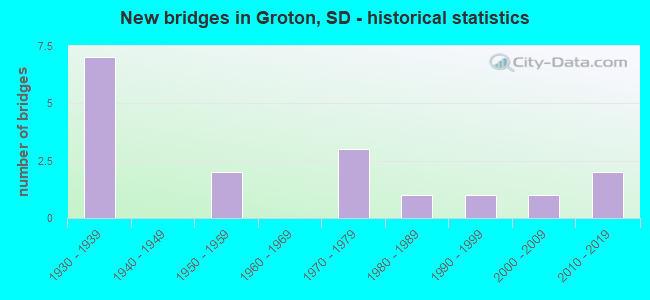
- New bridges - historical statistics
- 71930-1939
- 21950-1959
- 31970-1979
- 11980-1989
- 11990-1999
- 12000-2009
- 22010-2019
FCC Registered Cell Phone Towers:
2 (See the full list of FCC Registered Cell Phone Towers in Groton)FCC Registered Antenna Towers:
17 (See the full list of FCC Registered Antenna Towers)FCC Registered Private Land Mobile Towers:
1 (See the full list of FCC Registered Private Land Mobile Towers in Groton, SD)FCC Registered Broadcast Land Mobile Towers:
12 (See the full list of FCC Registered Broadcast Land Mobile Towers)FCC Registered Microwave Towers:
2- Groton, 40845 133rd Street (Lat: 45.458389 Lon: -98.052806), Type: Ltower, Structure height: 55.5 m, Overall height: 58.2 m, Call Sign: WQSY689,
Assigned Frequencies: 6226.89 MHz, 6286.19 MHz, Grant Date: 12/10/2013, Expiration Date: 12/10/2023, Cancellation Date: 05/08/2014, Certifier: John E Monday, Registrant: At&t Mobility LLC, 2200 N. Greenville Ave., 1w, Richardson, TX 75082, Phone: (972) 234-7003, Fax: (972) 301-6893, Email:
- GROTON, 5 Mi S Of (Lat: 45.374111 Lon: -98.103139), Type: Mtower, Structure height: 30.5 m, Call Sign: WHJ623,
Assigned Frequencies: 6375.14 MHz, 6404.79 MHz, 6197.24 MHz, 6375.14 MHz, 6404.79 MHz, 6197.24 MHz, 6286.19 MHz, 6286.19 MHz, Grant Date: 07/28/2018, Expiration Date: 09/25/2028, Registrant: Basin Electric Power Cooperative, 1717 E Interstate Ave, Bismarck, ND 58503, Phone: (701) 557-5669, Email:
FCC Registered Amateur Radio Licenses:
1- Call Sign: W0OYQ, Grant Date: 05/21/1996, Expiration Date: 05/21/2006, Cancellation Date: 05/22/2008, Registrant: Robert A Peterson, 608 N 2nd St, Groton, SD 57445
FAA Registered Aircraft:
2- Aircraft: PIPER PA-18-135 (Category: Land, Seats: 2, Weight: Up to 12,499 Pounds, Speed: 97 mph), Engine: LYCOMING 0-290 SERIES (140 HP) (Reciprocating)
N-Number: 30GW, N30GW, N-30GW, Serial Number: 18-3939, Year manufactured: 1954, Airworthiness Date: 07/11/1994, Certificate Issue Date: 05/09/2017
Registrant (Individual): Brett J Anderson, 203 Meadowbrook Ln, Groton, SD 57445 - Aircraft: MCDONNELL DOUGLAS HELICOPTER 600N (Category: Land, Seats: 6, Weight: Up to 12,499 Pounds), Engine: ROLLS-ROYC 250-C47M (650 HP) (Turbo-shaft)
N-Number: 3500X, N3500X, N-3500X, Serial Number: RN047, Year manufactured: 2000, Airworthiness Date: 08/28/2019, Certificate Issue Date: 11/12/2019
Registrant (LLC): Helicopter Flight Services LLC, 12702 406th Ave, Groton, SD 57445
2006 - 2018 National Fire Incident Reporting System (NFIRS) incidents
- Fire incident types reported to NFIRS in Groton, SD
- 4842.9%Outside Fires
- 2925.9%Structure Fires
- 1917.0%Other
- 1614.3%Mobile Property/Vehicle Fires
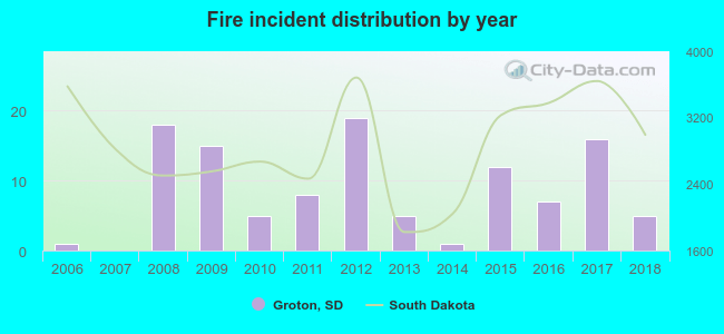 According to the data from the years 2006 - 2018 the average number of fire incidents per year is 9. The highest number of fires - 19 took place in 2012, and the least - 0 in 2007. The data has a growing trend.
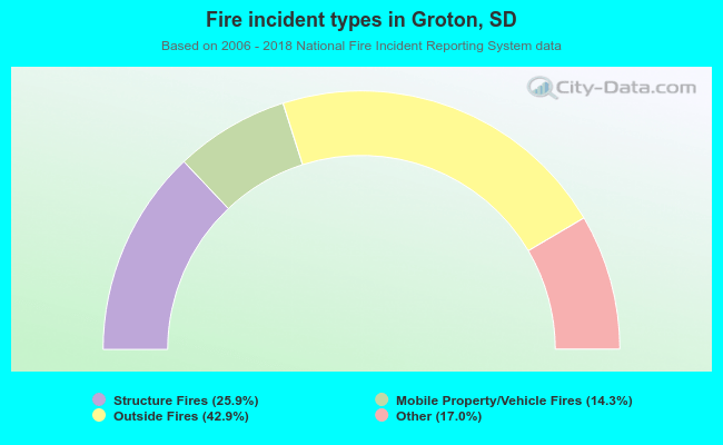 When looking into fire subcategories, the most reports belonged to: Outside Fires (42.9%), and Structure Fires (25.9%).
| Most common first names in Groton, SD among deceased individuals | ||
| Name | Count | Lived (average) |
|---|---|---|
| William | 20 | 76.9 years |
| George | 15 | 80.6 years |
| Robert | 13 | 73.2 years |
| Ruth | 12 | 80.6 years |
| Mary | 10 | 85.3 years |
| Walter | 10 | 77.0 years |
| Albert | 10 | 81.1 years |
| Arthur | 10 | 81.2 years |
| Emma | 10 | 90.7 years |
| John | 10 | 75.8 years |
| Most common last names in Groton, SD among deceased individuals | ||
| Last name | Count | Lived (average) |
|---|---|---|
| Johnson | 22 | 82.2 years |
| Rix | 14 | 87.7 years |
| Zoellner | 14 | 78.6 years |
| Olson | 10 | 81.1 years |
| Peterson | 9 | 80.8 years |
| Nehls | 9 | 77.1 years |
| Erdmann | 8 | 79.5 years |
| Bahr | 8 | 78.0 years |
| Anderson | 7 | 84.1 years |
| Jensen | 7 | 82.3 years |
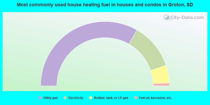
- 66.5%Utility gas
- 23.2%Electricity
- 8.9%Bottled, tank, or LP gas
- 1.4%Fuel oil, kerosene, etc.
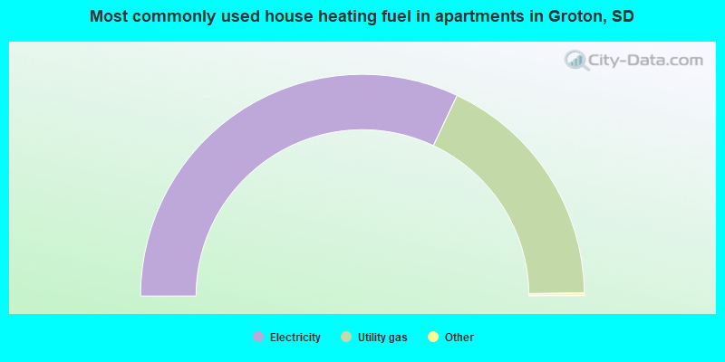
- 64.3%Electricity
- 35.7%Utility gas
Groton compared to South Dakota state average:
- Unemployed percentage significantly below state average.
- Black race population percentage significantly below state average.
- Median age significantly above state average.
- Foreign-born population percentage significantly below state average.
- Length of stay since moving in significantly above state average.

|
Total of 9 patent applications in 2008-2024.