Greenwood, Alabama
Submit your own pictures of this place and show them to the world
- OSM Map
- General Map
- Google Map
- MSN Map

| Males: 7,100 | |
| Females: 7,309 |
| Median resident age: | 36.2 years |
| Alabama median age: | 35.8 years |
Zip code: 35022
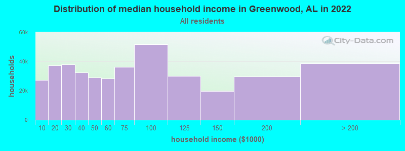
| Greenwood: | $90,669 |
| AL: | $59,674 |
Estimated per capita income in 2022: $43,728 (it was $23,141 in 2000)
Greenwood CCD income, earnings, and wages data
Estimated median house or condo value in 2022: $386,628 (it was $143,600 in 2000)
| Greenwood: | $386,628 |
| AL: | $200,900 |
Mean prices in 2022: all housing units: $309,295; detached houses: $322,061; townhouses or other attached units: $218,406; in 2-unit structures: $208,395; in 3-to-4-unit structures: $229,321; in 5-or-more-unit structures: $282,627; mobile homes: $67,878; occupied boats, rvs, vans, etc.: $104,744
Detailed information about poverty and poor residents in Greenwood, AL


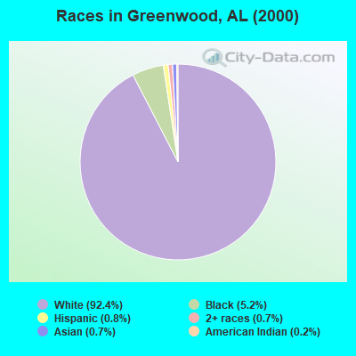
- 13,33092.4%White alone
- 7475.2%Black alone
- 1090.8%Hispanic
- 980.7%Asian alone
- 1070.7%Two or more races
- 280.2%American Indian alone
- 70.05%Other race alone
 Recent articles from our blog. Our writers, many of them Ph.D. graduates or candidates, create easy-to-read articles on a wide variety of topics.
Current Local Time: CST time zone
Land area: 49.9 square miles.
Population density: 289 people per square mile (very low).

| Greenwood CCD: | 0.5% ($736) |
| Alabama: | 0.4% ($289) |
Nearest city with pop. 50,000+: Hoover, AL  (8.9 miles , pop. 62,742).
Nearest city with pop. 200,000+: Birmingham, AL (15.8 miles , pop. 242,820).
Nearest city with pop. 1,000,000+: Houston, TX (555.1 miles , pop. 1,953,631).
Nearest cities:
), ), ), Latitude: 33.32 N, Longitude: 86.94 W
Area code commonly used in this area: 205

| Here: | 2.6% |
| Alabama: | 2.6% |
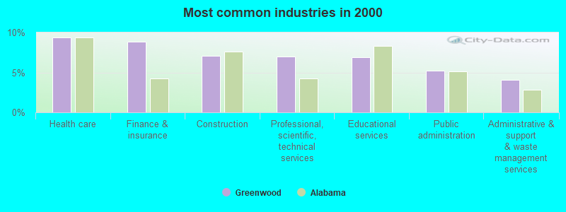
- Health care (9.3%)
- Finance & insurance (8.9%)
- Construction (7.0%)
- Professional, scientific, technical services (7.0%)
- Educational services (6.9%)
- Public administration (5.2%)
- Administrative & support & waste management services (4.1%)
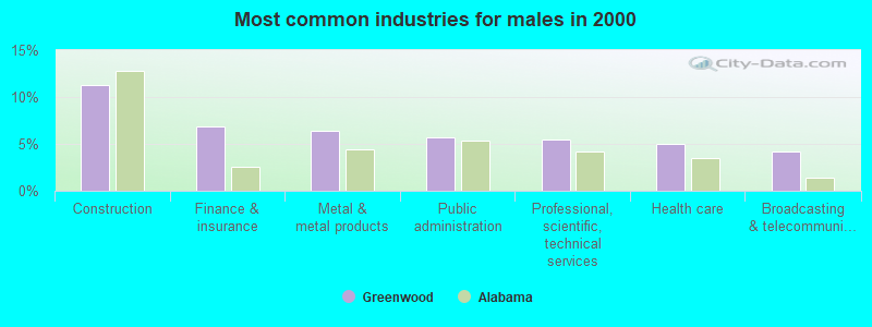
- Construction (11.3%)
- Finance & insurance (6.9%)
- Metal & metal products (6.4%)
- Public administration (5.8%)
- Professional, scientific, technical services (5.5%)
- Health care (5.0%)
- Broadcasting & telecommunications (4.2%)
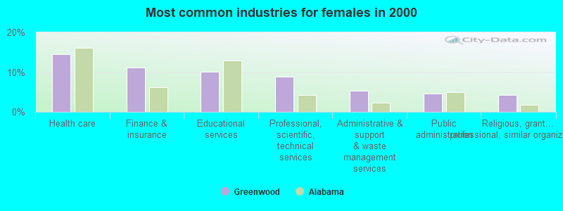
- Health care (14.5%)
- Finance & insurance (11.2%)
- Educational services (10.0%)
- Professional, scientific, technical services (8.8%)
- Administrative & support & waste management services (5.4%)
- Public administration (4.5%)
- Religious, grantmaking, civic, professional, similar organizations (4.3%)
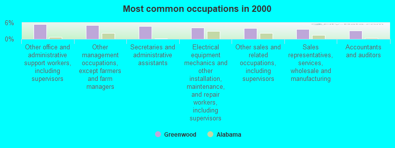
- Other office and administrative support workers, including supervisors (5.5%)
- Other management occupations, except farmers and farm managers (5.0%)
- Secretaries and administrative assistants (4.8%)
- Electrical equipment mechanics and other installation, maintenance, and repair workers, including supervisors (4.1%)
- Other sales and related occupations, including supervisors (4.0%)
- Sales representatives, services, wholesale and manufacturing (3.6%)
- Accountants and auditors (3.1%)
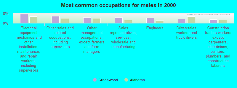
- Electrical equipment mechanics and other installation, maintenance, and repair workers, including supervisors (7.6%)
- Other sales and related occupations, including supervisors (5.8%)
- Other management occupations, except farmers and farm managers (4.8%)
- Sales representatives, services, wholesale and manufacturing (4.8%)
- Engineers (4.5%)
- Driver/sales workers and truck drivers (3.3%)
- Construction traders workers except carpenters, electricians, painters, plumbers, and construction laborers (3.2%)
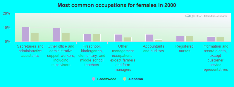
- Secretaries and administrative assistants (10.4%)
- Other office and administrative support workers, including supervisors (9.6%)
- Preschool, kindergarten, elementary, and middle school teachers (5.5%)
- Other management occupations, except farmers and farm managers (5.2%)
- Accountants and auditors (5.2%)
- Registered nurses (4.1%)
- Information and record clerks, except customer service representatives (3.5%)
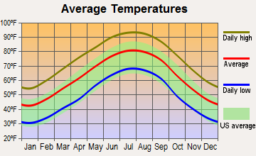
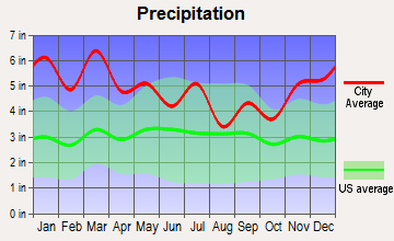
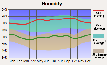
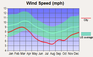
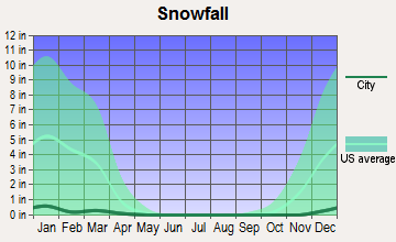
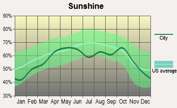
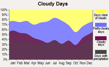
Average climate in Greenwood, Alabama
Based on data reported by over 4,000 weather stations
(lower is better)
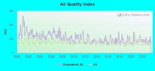
Air Quality Index (AQI) level in 2022 was 81.6. This is about average.
| City: | 81.6 |
| U.S.: | 72.6 |
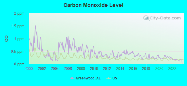
Carbon Monoxide (CO) [ppm] level in 2022 was 0.170. This is significantly better than average. Closest monitor was 11.3 miles away from the city center.
| City: | 0.170 |
| U.S.: | 0.251 |
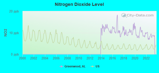
Nitrogen Dioxide (NO2) [ppb] level in 2022 was 8.53. This is significantly worse than average. Closest monitor was 5.4 miles away from the city center.
| City: | 8.53 |
| U.S.: | 5.11 |
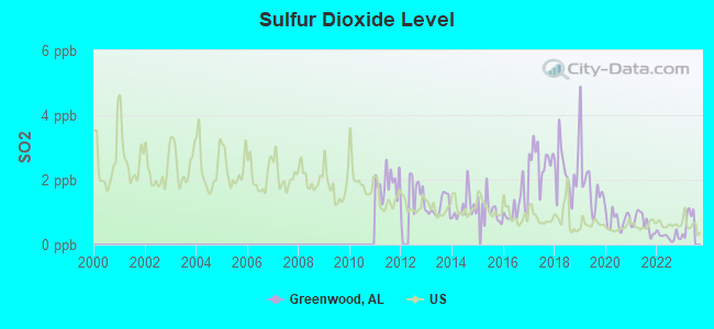
Sulfur Dioxide (SO2) [ppb] level in 2022 was 0.254. This is significantly better than average. Closest monitor was 5.4 miles away from the city center.
| City: | 0.254 |
| U.S.: | 1.515 |
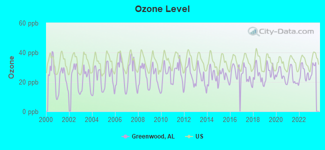
Ozone [ppb] level in 2022 was 25.6. This is better than average. Closest monitor was 6.6 miles away from the city center.
| City: | 25.6 |
| U.S.: | 33.3 |
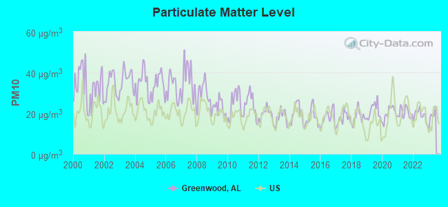
Particulate Matter (PM10) [µg/m3] level in 2022 was 18.8. This is about average. Closest monitor was 3.8 miles away from the city center.
| City: | 18.8 |
| U.S.: | 19.2 |
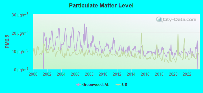
Particulate Matter (PM2.5) [µg/m3] level in 2022 was 8.72. This is about average. Closest monitor was 3.8 miles away from the city center.
| City: | 8.72 |
| U.S.: | 8.11 |
Tornado activity:
Greenwood-area historical tornado activity is slightly above Alabama state average. It is 131% greater than the overall U.S. average.
On 4/4/1977, a category F5 (max. wind speeds 261-318 mph) tornado 13.6 miles away from the Greenwood place center killed 22 people and injured 130 people and caused between $5,000,000 and $50,000,000 in damages.
On 4/8/1998, a category F5 tornado 18.2 miles away from the place center killed 32 people and injured 259 people and caused $200 million in damages.
Earthquake activity:
Greenwood-area historical earthquake activity is significantly above Alabama state average. It is 127% greater than the overall U.S. average.On 1/18/1999 at 07:00:53, a magnitude 4.8 (4.8 MB, 4.0 LG, Depth: 0.6 mi, Class: Light, Intensity: IV - V) earthquake occurred 19.1 miles away from the city center
On 4/29/2003 at 08:59:39, a magnitude 4.9 (4.4 MB, 4.6 MW, 4.9 LG) earthquake occurred 110.5 miles away from the city center
On 6/24/1975 at 11:11:36, a magnitude 4.5 (4.5 MB) earthquake occurred 58.7 miles away from the city center
On 10/24/1997 at 08:35:17, a magnitude 4.9 (4.8 MB, 4.2 MS, 4.9 LG, Depth: 6.2 mi) earthquake occurred 153.4 miles away from Greenwood center
On 4/29/2003 at 08:59:39, a magnitude 4.6 (4.6 MW, Depth: 12.3 mi) earthquake occurred 110.5 miles away from Greenwood center
On 11/7/2004 at 11:20:21, a magnitude 4.3 (4.3 MW, Depth: 3.1 mi) earthquake occurred 74.1 miles away from the city center
Magnitude types: regional Lg-wave magnitude (LG), body-wave magnitude (MB), surface-wave magnitude (MS), moment magnitude (MW)
Natural disasters:
The number of natural disasters in Jefferson County (32) is a lot greater than the US average (15).Major Disasters (Presidential) Declared: 24
Emergencies Declared: 6
Causes of natural disasters: Storms: 18, Tornadoes: 16, Floods: 14, Hurricanes: 6, Winds: 6, Drought: 1, Fire: 1, Heavy Rain: 1, Snowfall: 1, Winter Storm: 1, Other: 1 (Note: some incidents may be assigned to more than one category).
Hospitals and medical centers near Greenwood:
- GOLDEN LIVING CENTER - MEADOWOOD (Nursing Home, about 5 miles away; BESSEMER, AL)
- MID-SOUTH HOME HEALTH (Home Health Center, about 5 miles away; BESSEMER, AL)
- MEDICAL WEST, AN AFFILIATE OF UAB HEALTH SYSTEM Acute Care Hospitals (about 5 miles away; BESSEMER, AL)
- UAB MEDICAL WEST HOSPICE (Hospital, about 5 miles away; BESSEMER, AL)
- UAB MEDICAL WEST SKILLED NURSI (Nursing Home, about 5 miles away; BESSEMER, AL)
- BESSEMER KIDNEY CENTER (Dialysis Facility, about 5 miles away; BESSEMER, AL)
- JEWEL DIALYSIS (Dialysis Facility, about 6 miles away; BESSEMER, AL)
Colleges/universities with over 2000 students nearest to Greenwood:
- Lawson State Community College-Birmingham Campus (about 10 miles; Birmingham, AL; Full-time enrollment: 2,695)
- Virginia College-Birmingham (about 13 miles; Birmingham, AL; FT enrollment: 8,167)
- Samford University (about 14 miles; Birmingham, AL; FT enrollment: 3,829)
- University of Alabama at Birmingham (about 15 miles; Birmingham, AL; FT enrollment: 14,853)
- University of Montevallo (about 16 miles; Montevallo, AL; FT enrollment: 2,826)
- Jefferson State Community College (about 27 miles; Birmingham, AL; FT enrollment: 6,041)
- The University of Alabama (about 36 miles; Tuscaloosa, AL; FT enrollment: 30,931)
Public schools in Greenwood:
- THE BOYD SCHOOL (Students: 502, Location: 20856 EASTERN VALLEY RD.)
- TRI-WILL/PORTA-CRAS SCHOOL (Location: 65 ENTERPRISE LOOP)
Points of interest:
Notable locations in Greenwood: Twin Lakes Country Club (A), Pauline Fletcher Camp (B), Indian Ford Volunteer Fire Department (C), McAdory Fire and Rescue Station 2 (D), McAdory Fire and Rescue Station 1 (E), Bessemer Fire Department Station 3 (F). Display/hide their locations on the map
Churches in Greenwood include: Pleasant Hill United Methodist Church (A), Bellview Church (B), Bluff Ridge Church (C), Canaan Church (D), Morgan Church (E), Hillview Church (F), Shady Grove Church (G). Display/hide their locations on the map
Cemeteries: Marvin Chapel Cemetery (1), Massey Cemetery (2), Fairington Cemetery (3), Smithson Cemetery (4), George Cemetery (5). Display/hide their locations on the map
Reservoirs: Johnsons Lake (A), Guytons Lake (B), Indian Gap Lake (C), Baylor Lake (D), Norman Fountain Lake (E), Serene Lake Number 1 (F), Tannehill Valley Lake (G), Coleman Lakes (H). Display/hide their locations on the map
Streams, rivers, and creeks: Rocky Brook (A), Rice Creek (B), Cooley Creek (C), Clear Branch (D), Bob George Branch (E), Black Creek (F), Allen Brook (G). Display/hide their locations on the map
Park in Greenwood: Tannehill State Park (1). Display/hide its location on the map
| This place: | 2.7 people |
| Alabama: | 2.5 people |
| This place: | 79.1% |
| Whole state: | 67.8% |
| This place: | 2.9% |
| Whole state: | 4.7% |
Likely homosexual households (counted as self-reported same-sex unmarried-partner households)
- Lesbian couples: 0.4% of all households
- Gay men: 0.3% of all households
| This place: | 4.7% |
| Whole state: | 16.1% |
| This place: | 1.6% |
| Whole state: | 7.3% |
For population 15 years and over in Greenwood:
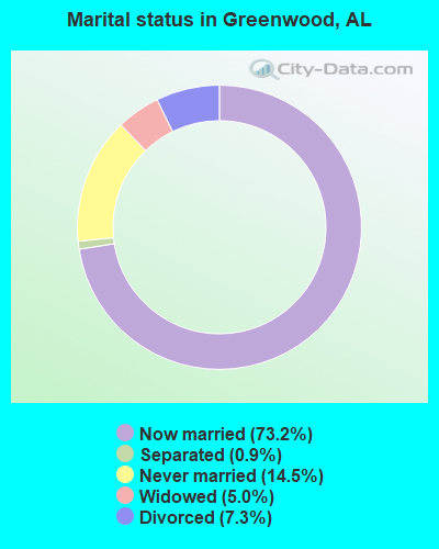
- Never married: 14.5%
- Now married: 73.2%
- Separated: 0.9%
- Widowed: 5.0%
- Divorced: 7.3%
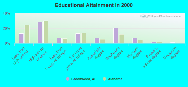
For population 25 years and over in Greenwood:
- High school or higher: 86.7%
- Bachelor's degree or higher: 30.6%
- Graduate or professional degree: 10.0%
- Unemployed: 2.3%
- Mean travel time to work (commute): 30.2 minutes
| Here: | 10.9 |
| Alabama average: | 13.2 |
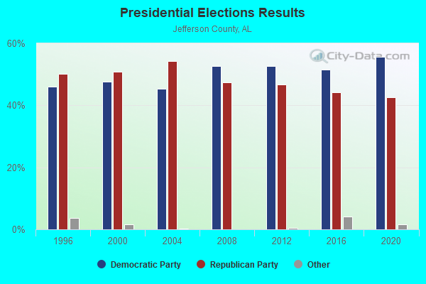
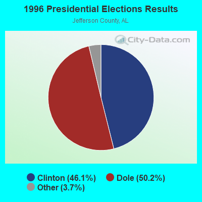
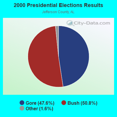
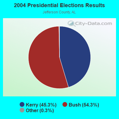
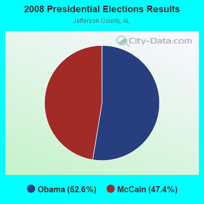
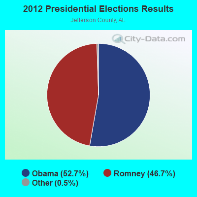
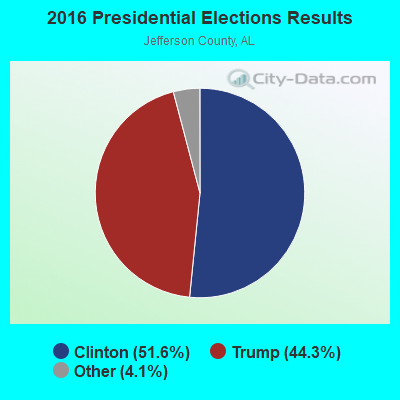
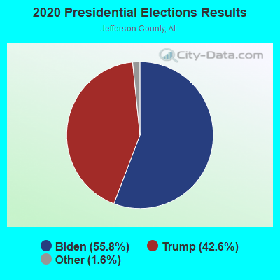
Graphs represent county-level data. Detailed 2008 Election Results
Religion statistics for Greenwood, AL (based on Jefferson County data)
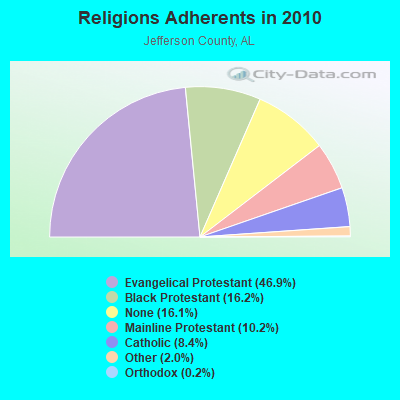
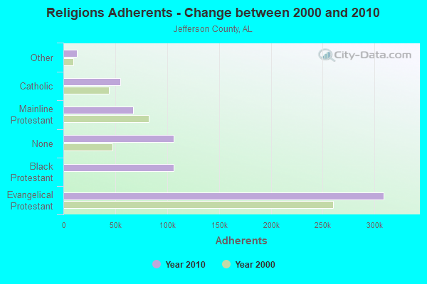
| Religion | Adherents | Congregations |
|---|---|---|
| Evangelical Protestant | 308,984 | 710 |
| Black Protestant | 106,653 | 257 |
| Mainline Protestant | 67,037 | 150 |
| Catholic | 55,083 | 32 |
| Other | 13,073 | 45 |
| Orthodox | 1,424 | 4 |
| None | 106,212 | - |
Food Environment Statistics:
| Jefferson County: | 2.05 / 10,000 pop. |
| Alabama: | 1.89 / 10,000 pop. |
| This county: | 0.18 / 10,000 pop. |
| Alabama: | 0.20 / 10,000 pop. |
| This county: | 0.99 / 10,000 pop. |
| State: | 0.65 / 10,000 pop. |
| This county: | 5.77 / 10,000 pop. |
| State: | 6.32 / 10,000 pop. |
| Jefferson County: | 5.42 / 10,000 pop. |
| Alabama: | 5.75 / 10,000 pop. |
| This county: | 12.4% |
| Alabama: | 11.8% |
| Jefferson County: | 31.1% |
| Alabama: | 31.7% |
| Here: | 12.0% |
| Alabama: | 13.5% |
6.20% of this county's 2020 resident taxpayers moved to other counties in 2021 ($76,918 average adjusted gross income)
| Here: | 6.20% |
| Alabama average: | 6.41% |
0.01% of residents moved to foreign countries ($73 average AGI)
Jefferson County: 0.01% Alabama average: 0.02%
Top counties to which taxpayers relocated from this county between 2020 and 2021:
| to Shelby County, AL | |
| to St. Clair County, AL | |
| to Blount County, AL |
Strongest AM radio stations in Greenwood:
- WJOX (690 AM; 50 kW; BIRMINGHAM, AL; Owner: CITADEL BROADCASTING COMPANY)
- WAPI (1070 AM; 50 kW; BIRMINGHAM, AL; Owner: CITADEL BROADCASTING COMPANY)
- WDJC (850 AM; 50 kW; BIRMINGHAM, AL; Owner: KIMTRON, INC.)
- WERC (960 AM; 5 kW; BIRMINGHAM, AL; Owner: CAPSTAR TX LIMITED PARTNERSHIP)
- WYDE (1260 AM; 5 kW; BIRMINGHAM, AL; Owner: KIMTRON, INC.)
- WSMQ (1450 AM; 1 kW; BESSEMER, AL; Owner: BESSEMER RADIO INC.)
- WRJS (1320 AM; 5 kW; BIRMINGHAM, AL; Owner: CXR HOLDINGS, INC.)
- WNSI (810 AM; 50 kW; JACKSONVILLE, AL; Owner: UNITED BROADCASTING NETWORK, INC.)
- WQCR (1500 AM; 2 kW; ALABASTER, AL; Owner: WGTT, INC.)
- WLPH (1480 AM; daytime; 5 kW; IRONDALE, AL; Owner: BIRMINGHAM CHRISTIAN RADIO, INC.)
- WJLD (1400 AM; 1 kW; FAIRFIELD, AL; Owner: RICHARDSON BROADCASTING CORPORATION)
- WAYE (1220 AM; 1 kW; BIRMINGHAM, AL; Owner: BIRMINGHAM CHRISTIAN RADIO, INC.)
- WATV (900 AM; 1 kW; BIRMINGHAM, AL)
Strongest FM radio stations in Greenwood:
- WMJJ (96.5 FM; BIRMINGHAM, AL; Owner: CAPSTAR TX LIMITED PARTNERSHIP)
- WQEN (103.7 FM; GADSDEN, AL; Owner: CAPSTAR TX LIMITED PARTNERSHIP)
- WZRR (99.5 FM; BIRMINGHAM, AL; Owner: CITADEL BROADCASTING COMPANY)
- WODL (97.3 FM; HOMEWOOD, AL; Owner: CXR HOLDINGS, INC.)
- WDJC-FM (93.7 FM; BIRMINGHAM, AL; Owner: KIMTRON, INC.)
- WYSF (94.5 FM; BIRMINGHAM, AL; Owner: CITADEL BROADCASTING COMPANY)
- WBHK (98.7 FM; WARRIOR, AL; Owner: CXR HOLDINGS, INC.)
- WZZK-FM (104.7 FM; BIRMINGHAM, AL; Owner: CXR HOLDINGS, INC.)
- WBPT (106.9 FM; BIRMINGHAM, AL; Owner: CXR HOLDINGS, INC.)
- WBHM (90.3 FM; BIRMINGHAM, AL; Owner: BD OF TRUSTEES/U OF AL AT BIRMINGHAM)
- W281AB (104.1 FM; MOUNTAIN BROOK, AL; Owner: FAMILY STATIONS, INC.)
- WDXB (102.5 FM; JASPER, AL; Owner: CAPSTAR TX LIMITED PARTNERSHIP)
- WBFR (89.5 FM; BIRMINGHAM, AL; Owner: FAMILY STATIONS, INC.)
- WQEM (101.5 FM; COLUMBIANA, AL; Owner: GLEN IRIS BAPTIST SCHOOL)
- WGIB (91.9 FM; BIRMINGHAM, AL; Owner: GLEN IRIS BAPTIST SCHOOL)
- WLJR (88.5 FM; BIRMINGHAM, AL; Owner: BRIARWOOD PRESBYTERIAN CHURCH)
- WANZ (100.7 FM; NORTHPORT, AL; Owner: APEX BRAODCASTING INC.)
- WVSU-FM (91.1 FM; BIRMINGHAM, AL; Owner: SAMFORD UNIVERSITY)
- WRAX (107.7 FM; BIRMINGHAM, AL; Owner: CITADEL BROADCASTING COMPANY)
- WENN (105.9 FM; TRUSSVILLE, AL; Owner: CAPSTAR TX LIMITED PARTNERSHIP)
TV broadcast stations around Greenwood:
- WBXA-CA (Channel 2; BIRMINGHAM, AL; Owner: THE BOX WORLDWIDE LLC)
- WABM (Channel 68; BIRMINGHAM, AL; Owner: BIRMINGHAM (WABM-TV) LICENSEE, INC.)
- WIAT (Channel 42; BIRMINGHAM, AL; Owner: MEDIA GENERAL COMMUNICATIONS, INC.)
- WBIQ (Channel 10; BIRMINGHAM, AL; Owner: ALABAMA EDUCATIONAL TELEVISION COMMISSION)
- WTTO (Channel 21; HOMEWOOD, AL; Owner: WTTO LICENSEE, LLC)
- WBRC (Channel 6; BIRMINGHAM, AL; Owner: WBRC LICENSE, INC.)
- WBMA-LP (Channel 58; BIRMINGHAM, AL; Owner: TV ALABAMA, INC.)
- WVTM-TV (Channel 13; BIRMINGHAM, AL; Owner: BIRMINGHAM BROADCASTING (WVTM-TV), LLC)
- WDBB (Channel 17; BESSEMER, AL; Owner: WDBB-TV, INC.)
- WCFT-TV (Channel 33; TUSCALOOSA, AL; Owner: TV ALABAMA, INCORPORATED)
- W15AZ (Channel 15; ALABASTER, AL; Owner: GLEN IRIS BAPTIST CHURCH SCHOOL)
- W27CM (Channel 27; BIRMINGHAM, AL; Owner: EQUITY BROADCASTING CORPORATION)
- W34BI (Channel 34; BIRMINGHAM, AL; Owner: VENTANA TELEVISION, INC.)
- W46DK (Channel 46; BIRMINGHAM, AL; Owner: TRINITY BROADCASTING NETWORK)
- W62BG (Channel 62; BIRMINGHAM, AL; Owner: WTTO LICENSEE, LLC)
- W49AY (Channel 49; BIRMINGHAM, AL; Owner: GLEN IRIS BAPTIST SCHOOL)
- WOTM-LP (Channel 19; MONTEVALLO, AL; Owner: JAMES DONALD EARLEY)
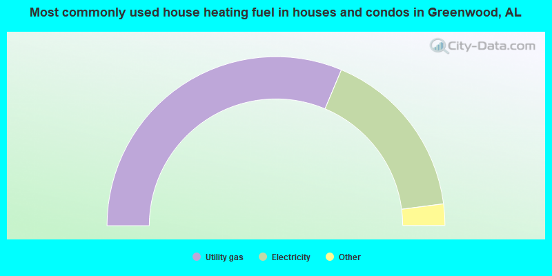
- 62.6%Utility gas
- 33.2%Electricity
- 3.6%Bottled, tank, or LP gas
- 0.4%Wood
- 0.2%No fuel used
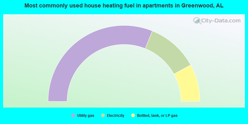
- 62.2%Utility gas
- 21.9%Electricity
- 15.9%Bottled, tank, or LP gas
Greenwood compared to Alabama state average:
- Median household income above state average.
- Median house value above state average.
- Unemployed percentage significantly below state average.
- Black race population percentage significantly below state average.
- Hispanic race population percentage significantly below state average.
- Median age below state average.
- Foreign-born population percentage significantly below state average.
- Renting percentage significantly below state average.
- Length of stay since moving in significantly above state average.
- Number of rooms per house significantly below state average.
- House age significantly below state average.
- Percentage of population with a bachelor's degree or higher above state average.
Greenwood on our top lists:
- #3 on the list of "Top 101 cities with largest percentage of females in occupations: accountants and auditors (population 5,000+)"
- #5 on the list of "Top 101 cities with largest percentage of females in occupations: religious workers (population 5,000+)"
- #7 on the list of "Top 101 cities with largest percentage of females in occupations: other financial specialists (population 5,000+)"
- #17 on the list of "Top 101 cities with largest percentage of females in industries: professional and commercial equipment and supplies merchant wholesalers (population 5,000+)"
- #17 on the list of "Top 101 cities with largest percentage of females in industries: religious, grantmaking, civic, professional, and similar organizations (population 5,000+)"
- #31 on the list of "Top 101 cities with largest percentage of males in industries: broadcasting and telecommunications (population 5,000+)"
- #35 on the list of "Top 101 cities with largest percentage of males in industries: sewing, needlework, and piece goods stores (population 5,000+)"
- #43 on the list of "Top 101 cities with largest percentage of females in occupations: secretaries and administrative assistants (population 5,000+)"
- #44 on the list of "Top 101 cities with largest percentage of males in occupations: extraction workers (population 5,000+)"
- #46 on the list of "Top 101 cities with largest percentage of males in industries: machinery, equipment, and supplies merchant wholesalers (population 5,000+)"
- #58 on the list of "Top 101 cities with largest percentage of females in occupations: plant and system operators (population 5,000+)"
- #62 on the list of "Top 101 cities with largest percentage of males in industries: pharmacies and drug stores (population 5,000+)"
- #64 on the list of "Top 101 cities with largest percentage of females in industries: metals and minerals, except petroleum, merchant wholesalers (population 5,000+)"
- #72 on the list of "Top 101 cities with largest percentage of females in industries: fuel dealers (population 5,000+)"
- #76 on the list of "Top 101 cities with largest percentage of males in industries: electrical and electronic goods merchant wholesalers (population 5,000+)"
- #84 on the list of "Top 101 cities with largest percentage of females in industries: broadcasting and telecommunications (population 5,000+)"
- #97 on the list of "Top 101 cities with largest percentage of males in industries: metal and metal products (population 5,000+)"
- #5 on the list of "Top 101 counties with the highest number of infant deaths per 1000 residents 2007-2013 (pop. 50,000+)"
- #5 on the list of "Top 101 counties with the most Black Protestant adherents"
- #5 on the list of "Top 101 counties with the most Black Protestant congregations"
- #9 on the list of "Top 101 counties with the highest average weight of females"
- #9 on the list of "Top 101 counties with the most Evangelical Protestant adherents"