Granville, Vermont
Submit your own pictures of this town and show them to the world
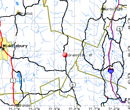
- OSM Map
- General Map
- Google Map
- MSN Map
Population change since 2000: -1.7%
 |
| Males: 156 | |
| Females: 142 |
| Median resident age: | 42.5 years |
| Vermont median age: | 45.8 years |
Zip codes: 05747.
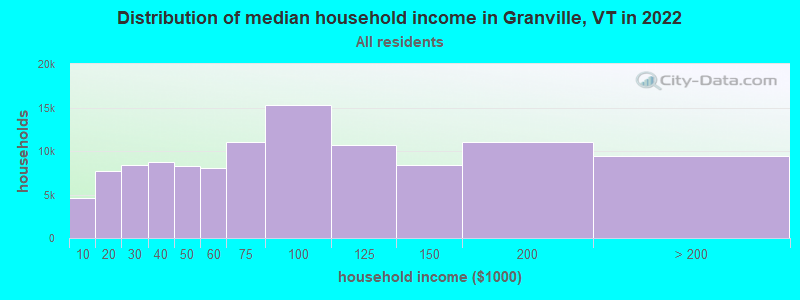
| Granville: | $65,024 |
| VT: | $73,991 |
Estimated per capita income in 2022: $31,696 (it was $14,453 in 2000)
Granville town income, earnings, and wages data
Estimated median house or condo value in 2022: $245,049 (it was $81,800 in 2000)
| Granville: | $245,049 |
| VT: | $304,700 |
Mean prices in 2022: all housing units: $400,302; detached houses: $427,258; townhouses or other attached units: $389,241; in 2-unit structures: $373,341; in 3-to-4-unit structures: $633,103; in 5-or-more-unit structures: $292,995; mobile homes: $101,709
Detailed information about poverty and poor residents in Granville, VT
Compare current foreclosures near Granville, VT:
| Photo | Address | Area | Beds / Baths | Price | Details |
|---|---|---|---|---|---|

|
#1
Rabbit Hollow Rd
Northfield, VT 05663
|
- sq. feet
|
- baths - beds |
show details | |

|
#2
Dartt Hill Rd, # Po122
Bethel, VT 05032
|
- sq. feet
|
- baths - beds |
show details | |

|
#3
Vt Route 64
Williamstown, VT 05679
|
- sq. feet
|
- baths - beds |
show details | |

|
#4
Pine St # 4
Bristol, VT 05443
|
- sq. feet
|
- baths - beds |
show details | |

|
#5
N Meadow Dr
Bristol, VT 05443
|
- sq. feet
|
- baths - beds |
show details | |

|
#6
Monarch Hill Rd
Tunbridge, VT 05077
|
- sq. feet
|
- baths - beds |
show details | |

|
#7
Terrace Dr
Northfield, VT 05663
|
- sq. feet
|
- baths - beds |
show details | |

|
#8
Vt Route 12
Northfield, VT 05663
|
- sq. feet
|
- baths - beds |
show details | |

|
Check over 1 million property listings on Foreclosure.com!
|
browse all offers | |||

- 28495.3%White alone
- 51.7%Two or more races
- 41.3%Hispanic
- 31.0%American Indian alone
- 20.7%Asian alone
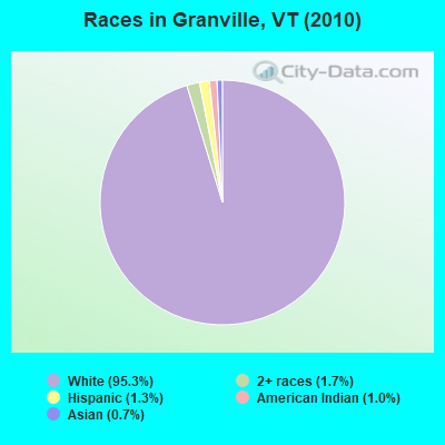
Races in Granville detailed stats: ancestries, foreign born residents, place of birth
 Recent articles from our blog. Our writers, many of them Ph.D. graduates or candidates, create easy-to-read articles on a wide variety of topics.


 | Driving to VT from LI this Fall (20 replies) |
| Poultney area (2 replies) |
| Lamoille County (6 replies) |
| Day Trips from the Burlington area (7 replies) |
| A week in Vermont is like GOLD to us (10 replies) |
| How long would take me drive from Mount Mansfield, VT to North Adams, MA on Route 100?? (14 replies) |
Latest news from Granville, VT collected exclusively by city-data.com from local newspapers, TV, and radio stations
Ancestries: English (25.7%), United States (22.4%), Irish (17.2%), French (16.5%), German (12.2%), Italian (11.2%).
Current Local Time: EST time zone
Elevation: 1013 feet
Land area: 52.2 square miles.
Population density: 5.7 people per square mile (very low).
23 residents are foreign born (4.6% Europe, 1.7% Asia).
| This town: | 7.6% |
| Vermont: | 3.8% |
| Granville town: | 1.1% ($900) |
| Vermont: | 2.0% ($2,196) |
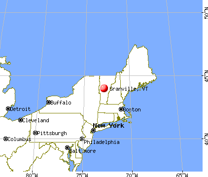
Nearest city with pop. 50,000+: Manchester, NH  (98.3 miles , pop. 107,006).
Nearest city with pop. 200,000+: Boston, MA (145.4 miles , pop. 589,141).
Nearest city with pop. 1,000,000+: Bronx, NY (224.4 miles , pop. 1,332,650).
Nearest cities:
), ), ), ), ), )Latitude: 44.00 N, Longitude: 72.83 W
Area code commonly used in this area: 802

| Here: | 2.6% |
| Vermont: | 2.0% |
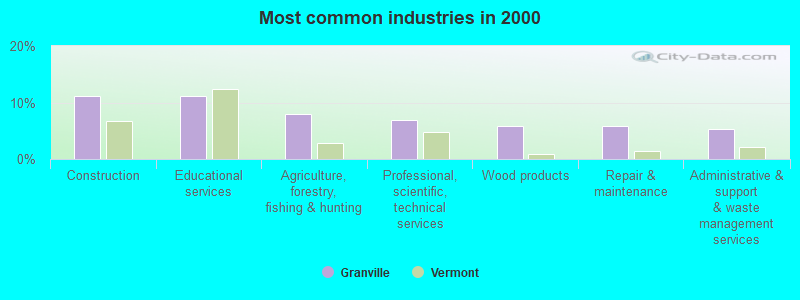
- Construction (11.2%)
- Educational services (11.2%)
- Agriculture, forestry, fishing & hunting (8.0%)
- Professional, scientific, technical services (6.9%)
- Wood products (5.9%)
- Repair & maintenance (5.9%)
- Administrative & support & waste management services (5.3%)
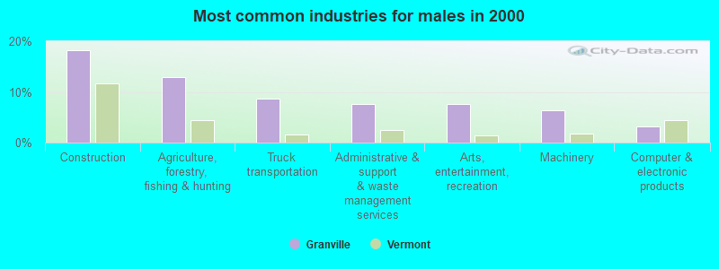
- Construction (18.3%)
- Agriculture, forestry, fishing & hunting (12.9%)
- Truck transportation (8.6%)
- Administrative & support & waste management services (7.5%)
- Arts, entertainment, recreation (7.5%)
- Machinery (6.5%)
- Computer & electronic products (3.2%)
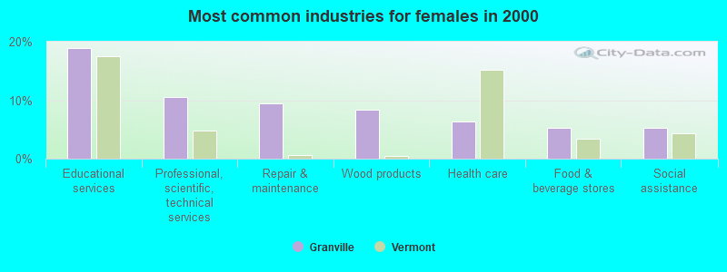
- Educational services (18.9%)
- Professional, scientific, technical services (10.5%)
- Repair & maintenance (9.5%)
- Wood products (8.4%)
- Health care (6.3%)
- Food & beverage stores (5.3%)
- Social assistance (5.3%)
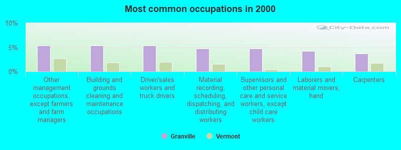
- Other management occupations, except farmers and farm managers (5.3%)
- Building and grounds cleaning and maintenance occupations (5.3%)
- Driver/sales workers and truck drivers (5.3%)
- Material recording, scheduling, dispatching, and distributing workers (4.8%)
- Supervisors and other personal care and service workers, except child care workers (4.8%)
- Laborers and material movers, hand (4.3%)
- Carpenters (3.7%)
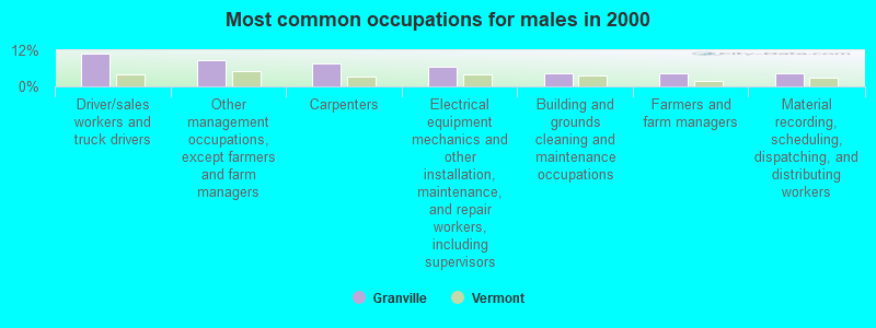
- Driver/sales workers and truck drivers (10.8%)
- Other management occupations, except farmers and farm managers (8.6%)
- Carpenters (7.5%)
- Electrical equipment mechanics and other installation, maintenance, and repair workers, including supervisors (6.5%)
- Building and grounds cleaning and maintenance occupations (4.3%)
- Farmers and farm managers (4.3%)
- Material recording, scheduling, dispatching, and distributing workers (4.3%)
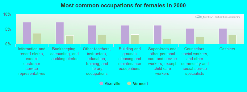
- Information and record clerks, except customer service representatives (7.4%)
- Bookkeeping, accounting, and auditing clerks (7.4%)
- Other teachers, instructors, education, training, and library occupations (6.3%)
- Building and grounds cleaning and maintenance occupations (6.3%)
- Supervisors and other personal care and service workers, except child care workers (6.3%)
- Counselors, social workers, and other community and social service specialists (5.3%)
- Cashiers (5.3%)
Average climate in Granville, Vermont
Based on data reported by over 4,000 weather stations


Earthquake activity:
Granville-area historical earthquake activity is significantly above Vermont state average. It is 70% smaller than the overall U.S. average.On 4/20/2002 at 10:50:47, a magnitude 5.3 (5.3 ML, Depth: 3.0 mi, Class: Moderate, Intensity: VI - VII) earthquake occurred 55.9 miles away from the city center
On 10/7/1983 at 10:18:46, a magnitude 5.3 (5.1 MB, 5.3 LG, 5.1 ML) earthquake occurred 75.5 miles away from Granville center
On 4/20/2002 at 10:50:47, a magnitude 5.2 (5.2 MB, 4.2 MS, 5.2 MW, 5.0 MW) earthquake occurred 55.6 miles away from the city center
On 1/19/1982 at 00:14:42, a magnitude 4.7 (4.5 MB, 4.7 MD, 4.5 LG, Class: Light, Intensity: IV - V) earthquake occurred 70.3 miles away from the city center
On 10/16/2012 at 23:12:25, a magnitude 4.7 (4.7 ML, Depth: 10.0 mi) earthquake occurred 111.8 miles away from the city center
On 6/16/1995 at 12:13:11, a magnitude 3.8 (3.8 LG, Depth: 3.1 mi, Class: Light, Intensity: II - III) earthquake occurred 49.4 miles away from Granville center
Magnitude types: regional Lg-wave magnitude (LG), body-wave magnitude (MB), duration magnitude (MD), local magnitude (ML), surface-wave magnitude (MS), moment magnitude (MW)
Natural disasters:
The number of natural disasters in Addison County (23) is greater than the US average (15).Major Disasters (Presidential) Declared: 16
Emergencies Declared: 3
Causes of natural disasters: Floods: 16, Storms: 15, Drought: 1, Heavy Rain: 1, Hurricane: 1, Ice Storm: 1, Landslide: 1, Snow: 1, Snowstorm: 1, Tornado: 1, Tropical Storm: 1, Wind: 1, Winter Storm: 1, Other: 1 (Note: some incidents may be assigned to more than one category).
Hospitals and medical centers near Granville:
- GIFFORD ELDERLY CARE INC (Nursing Home, about 10 miles away; RANDOLPH, VT)
- GIFFORD MEDICAL CENTER Critical Access Hospitals (about 10 miles away; RANDOLPH, VT)
- MENIG EXTENDED CARE (Nursing Home, about 10 miles away; RANDOLPH, VT)
- MAYO HEALTHCARE INC. (Nursing Home, about 14 miles away; NORTHFIELD, VT)
Colleges/universities with over 2000 students nearest to Granville:
- Norwich University (about 13 miles; Northfield, VT; Full-time enrollment: 4,221)
- Middlebury College (about 18 miles; Middlebury, VT; FT enrollment: 3,077)
- Castleton State College (about 33 miles; Castleton, VT; FT enrollment: 2,079)
- Dartmouth College (about 34 miles; Hanover, NH; FT enrollment: 6,030)
- Champlain College (about 38 miles; Burlington, VT; FT enrollment: 2,623)
- University of Vermont (about 39 miles; Burlington, VT; FT enrollment: 11,566)
- Saint Michael's College (about 39 miles; Colchester, VT; FT enrollment: 2,336)
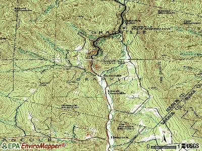
Points of interest:
Notable location: Granville Volunteer Fire Department (A). Display/hide its location on the map
Cemeteries: North Hollow Cemetery (1), Hubbard Cemetery (2), South Hollow Cemetery (3), Elmwood Cemetery (4). Display/hide their locations on the map
Streams, rivers, and creeks: Thatcher Brook (A), Deer Hollow Brook (B), Sandusky Brook (C), Albee Brook (D), Alder Meadow Brook (E), East Granville Brook (F), Kendall Brook (G), Gulf Brook (H), Patterson Brook (I). Display/hide their locations on the map
Park in Granville: Granville State Reservation (1). Display/hide its location on the map
| This town: | 2.2 people |
| Vermont: | 2.3 people |
| This town: | 61.0% |
| Whole state: | 62.5% |
| This town: | 16.2% |
| Whole state: | 9.2% |
Likely homosexual households (counted as self-reported same-sex unmarried-partner households)
- Lesbian couples: 0.7% of all households
- Gay men: 0.0% of all households
| This town: | 11.5% |
| Whole state: | 9.4% |
| This town: | 2.9% |
| Whole state: | 3.6% |
For population 15 years and over in Granville:
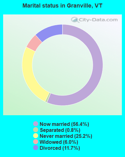
- Never married: 25.2%
- Now married: 56.4%
- Separated: 0.8%
- Widowed: 6.0%
- Divorced: 11.7%
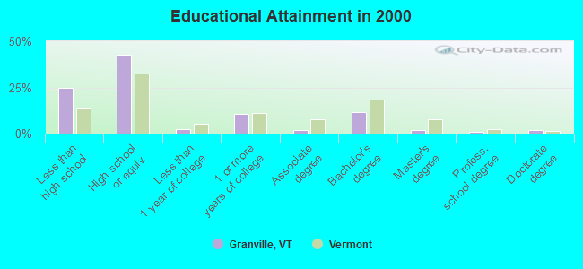
For population 25 years and over in Granville:
- High school or higher: 75.1%
- Bachelor's degree or higher: 16.6%
- Graduate or professional degree: 4.8%
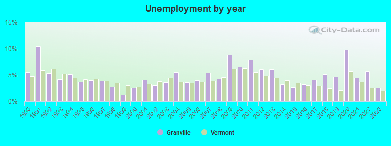
- Unemployed: 2.6%
- Mean travel time to work (commute): 22.4 minutes

| Here: | 12.2 |
| Vermont average: | 11.7 |
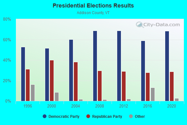
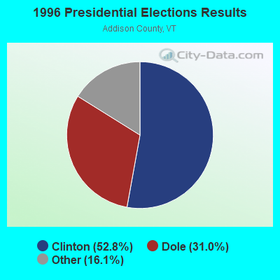

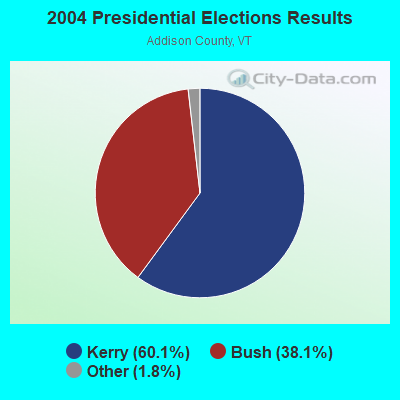
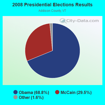
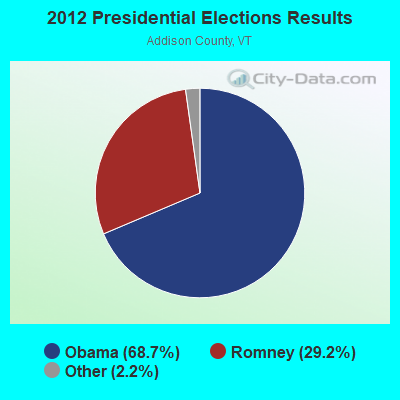
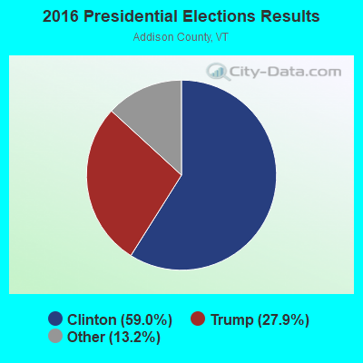
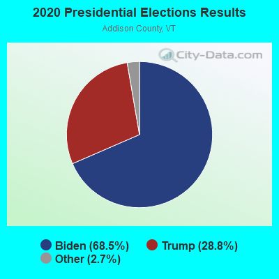
Graphs represent county-level data. Detailed 2008 Election Results
Religion statistics for Granville, VT (based on Addison County data)
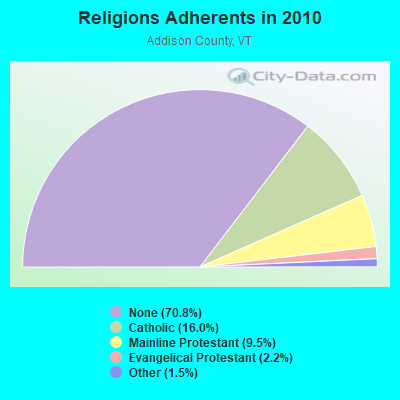
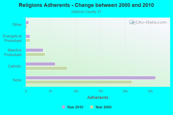
| Religion | Adherents | Congregations |
|---|---|---|
| Catholic | 5,892 | 6 |
| Mainline Protestant | 3,491 | 27 |
| Evangelical Protestant | 801 | 13 |
| Other | 560 | 6 |
| None | 26,077 | - |
Food Environment Statistics:
| Here: | 4.64 / 10,000 pop. |
| Vermont: | 3.84 / 10,000 pop. |
| Addison County: | 1.36 / 10,000 pop. |
| Vermont: | 1.95 / 10,000 pop. |
| Addison County: | 6.55 / 10,000 pop. |
| State: | 6.40 / 10,000 pop. |
| This county: | 8.45 / 10,000 pop. |
| Vermont: | 11.52 / 10,000 pop. |
| This county: | 5.8% |
| Vermont: | 6.8% |
| Addison County: | 20.9% |
| State: | 22.3% |
| Here: | 9.1% |
| Vermont: | 13.3% |
Strongest AM radio stations in Granville:
- WDEV (550 AM; 5 kW; WATERBURY, VT; Owner: RADIO VERMONT, INC.)
- WCHP (760 AM; 35 kW; CHAMPLAIN, NY; Owner: CHAMPLAIN RADIO, INC.)
- WWWT (1320 AM; 1 kW; RANDOLPH, VT; Owner: CAPSTAR TX LIMITED PARTNERSHIP)
- WGY (810 AM; 50 kW; SCHENECTADY, NY; Owner: CLEAR CHANNEL BROADCASTING LICENSES, INC.)
- WNNZ (640 AM; 50 kW; WESTFIELD, MA; Owner: CLEAR CHANNEL BROADCASTING LICENSES, INC.)
- WSYB (1380 AM; 5 kW; RUTLAND, VT; Owner: CAPSTAR TX LIMITED PARTNERSHIP)
- WVMT (620 AM; 5 kW; BURLINGTON, VT; Owner: SISON BROADCASTING, INC.)
- WICY (1490 AM; 50 kW; MALONE, NY; Owner: CARTIER COMMUNICATIONS INC.)
- WRKO (680 AM; 50 kW; BOSTON, MA; Owner: ENTERCOM BOSTON LICENSE, LLC)
- WCRN (830 AM; 50 kW; WORCESTER, MA; Owner: CARTER BROADCASTING CORPORATION)
- WNTK (1020 AM; 10 kW; NEWPORT, NH; Owner: KOOR COMMUNICATIONS, INC.)
- WPTR (1540 AM; 50 kW; ALBANY, NY; Owner: KIMTRON, INC.)
- WTWN (1100 AM; daytime; 5 kW; WELLS RIVER, VT; Owner: PUFFER BROADCASTING, INC.)
Strongest FM radio stations in Granville:
- WDEV-FM (96.1 FM; WARREN, VT; Owner: RADIO VERMONT, INC.)
- WEBK (105.3 FM; KILLINGTON, VT; Owner: 6 JOHNSON ROAD LICENSES, INC.)
- WJEN (94.5 FM; RUTLAND, VT; Owner: 6 JOHNSON ROAD LICENSES, INC.)
- WJJR (98.1 FM; RUTLAND, VT; Owner: 6 JOHNSON ROAD LICENSES, INC.)
- WZRT (97.1 FM; RUTLAND, VT; Owner: CAPSTAR TX LIMITED PARTNERSHIP)
- WGLV (91.7 FM; WOODSTOCK, VT; Owner: CHRISTIAN MINISTRIES INC)
- WHDQ-FM1 (106.1 FM; RUTLAND, VT; Owner: GREAT NORTHERN RADIO, L.L.C.)
- WCVT (101.7 FM; STOWE, VT; Owner: RADIO VERMONT CLASSICS, L.L.C.)
- WEXP (101.5 FM; BRANDON, VT; Owner: VOX VERMONT, L.L.C.)
- WNCS (104.7 FM; MONTPELIER, VT; Owner: MONTPELIER BROADCASTING, INC.)
- WVPS (107.9 FM; BURLINGTON, VT; Owner: VERMONT PUBLIC RADIO)
- WEZF (92.9 FM; BURLINGTON, VT; Owner: CAPSTAR TX LIMITED PARTNERSHIP)
- WLKC (103.3 FM; WATERBURY, VT; Owner: RADIO BROADCASTING SERVICES, INC.)
- WCVR-FM (102.1 FM; RANDOLPH, VT; Owner: CAPSTAR TX LIMITED PARTNERSHIP)
- WWFY (100.9 FM; BERLIN, VT; Owner: VOX ALLEGANY, LLC)
- WVPR (89.5 FM; WINDSOR, VT; Owner: VERMONT PUBLIC RADIO)
- WHDQ (106.1 FM; CLAREMONT, NH; Owner: GREAT NORTHERN RADIO, L.L.C.)
- WGLY-FM (91.5 FM; BOLTON, VT; Owner: CHRISTIAN MINISTRIES, INC.)
- WPKQ (103.7 FM; NORTH CONWAY, NH; Owner: CITADEL BROADCASTING COMPANY)
- WHOM (94.9 FM; MT. WASHINGTON, NH; Owner: CITADEL BROADCASTING COMPANY)
Granville fatal accident list:
Jun 29, 2007 09:48 PM, Sr-100, Lat: 44.027825, Lon: -72.834300, Vehicles: 1, Persons: 1, Fatalities: 1
Apr 30, 1999 01:00 PM, Sr-100, Vehicles: 1, Persons: 1, Fatalities: 1
Jul 3, 1990 04:20 PM, Vt 100, Vehicles: 1, Persons: 1, Fatalities: 1
- National Bridge Inventory (NBI) Statistics
- 14Number of bridges
- 56ft / 17.5mTotal length
- $1,672,000Total costs
- 10,381Total average daily traffic
- 911Total average daily truck traffic
- 10,946Total future (year 2028) average daily traffic
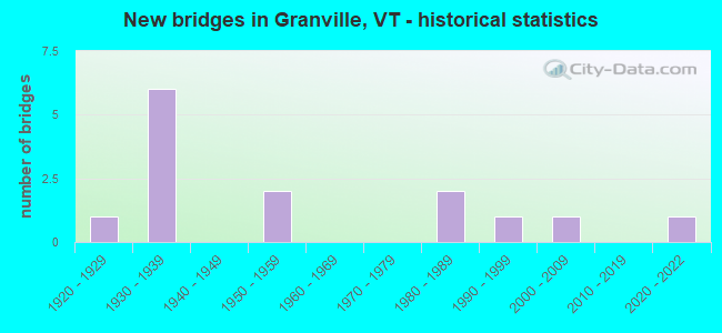
- New bridges - historical statistics
- 11920-1929
- 61930-1939
- 21950-1959
- 21980-1989
- 11990-1999
- 12000-2009
- 12020-2022
FCC Registered Amateur Radio Licenses:
1- Call Sign: KE1LP, Previous Call Sign: N1ZUD, Licensee ID: L00835551, Grant Date: 07/20/1999, Expiration Date: 10/22/2007, Cancellation Date: 06/04/2005, Certifier: Bruce S Greenleaf, Registrant: Bruce S Greenleaf, 3873 Vt Route 100, Granville, VT 05747
2002 - 2018 National Fire Incident Reporting System (NFIRS) incidents
- Fire incident types reported to NFIRS in Granville, VT
- 6565.0%Structure Fires
- 2424.0%Outside Fires
- 99.0%Mobile Property/Vehicle Fires
- 22.0%Other
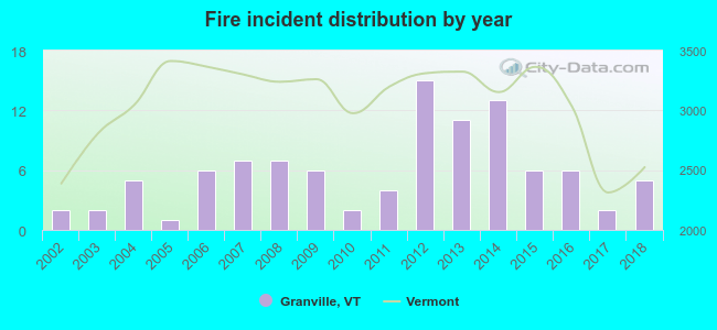 Based on the data from the years 2002 - 2018 the average number of fires per year is 6. The highest number of reported fire incidents - 15 took place in 2012, and the least - 1 in 2005. The data has an increasing trend.
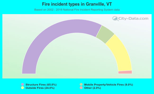 When looking into fire subcategories, the most reports belonged to: Structure Fires (65.0%), and Outside Fires (24.0%).
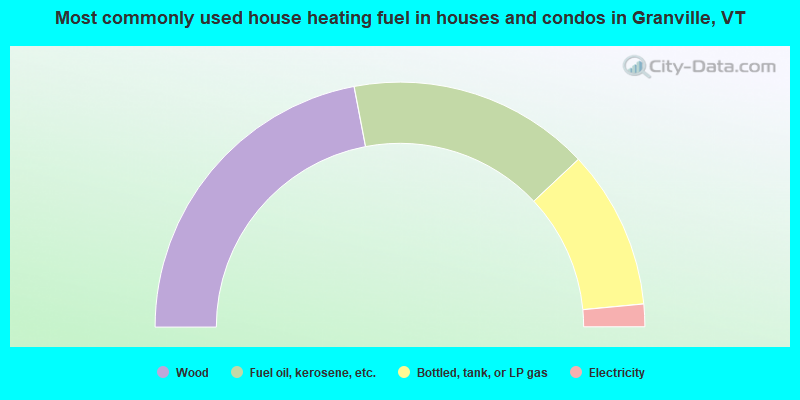
- 44.0%Wood
- 32.0%Fuel oil, kerosene, etc.
- 21.0%Bottled, tank, or LP gas
- 3.0%Electricity
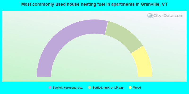
- 57.6%Fuel oil, kerosene, etc.
- 24.2%Bottled, tank, or LP gas
- 18.2%Wood
Granville compared to Vermont state average:
- Unemployed percentage significantly below state average.
- Black race population percentage significantly below state average.
- Hispanic race population percentage below state average.
- Foreign-born population percentage above state average.
- Renting percentage below state average.
- Length of stay since moving in significantly above state average.
- Number of rooms per house significantly below state average.
- House age significantly below state average.
- Percentage of population with a bachelor's degree or higher below state average.