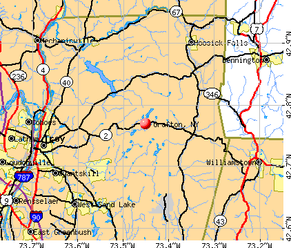
Grafton, New York
Grafton: Rt. 2, Across From The Entrance To Grafton Lakes State Park
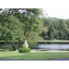
Grafton: Madonna Lake
Grafton: Rt. 2, Across From The Entrance To Grafton Lakes State Park
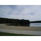
Grafton: Grafton State Park Beach

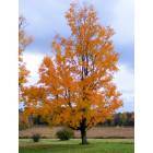
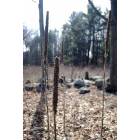
Grafton: A Quiet Grafton Road In March
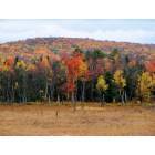
Grafton: Some Flora In Grafton
- add
your
Submit your own pictures of this town and show them to the world
- OSM Map
- General Map
- Google Map
- MSN Map
Population change since 2000: +7.2%
 |
| Males: 1,078 | |
| Females: 1,052 |
| Median resident age: | 41.6 years |
| New York median age: | 40.7 years |
Zip codes: 12052.
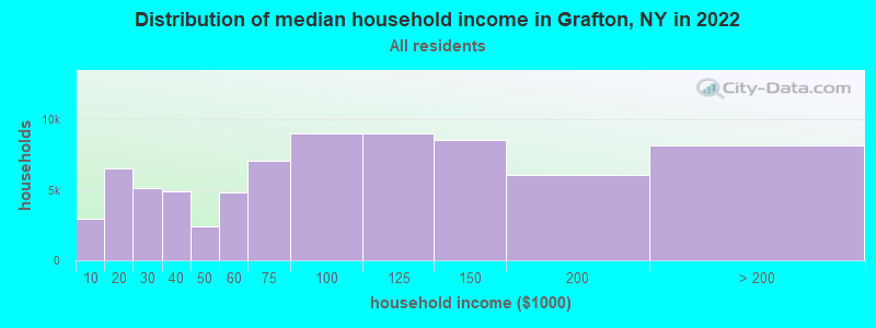
| Grafton: | $93,650 |
| NY: | $79,557 |
Estimated per capita income in 2022: $47,194 (it was $21,312 in 2000)
Grafton town income, earnings, and wages data
Estimated median house or condo value in 2022: $239,977 (it was $96,300 in 2000)
| Grafton: | $239,977 |
| NY: | $400,400 |
Mean prices in 2022: all housing units: $261,820; detached houses: $276,434; townhouses or other attached units: $265,307; in 2-unit structures: $183,863; in 3-to-4-unit structures: $134,506; in 5-or-more-unit structures: $370,413; mobile homes: $66,260
Detailed information about poverty and poor residents in Grafton, NY
Compare current foreclosures near Grafton, NY:


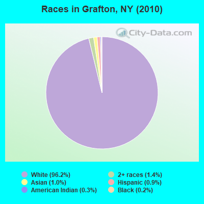
- 2,05096.2%White alone
- 291.4%Two or more races
- 211.0%Asian alone
- 200.9%Hispanic
- 60.3%American Indian alone
- 40.2%Black alone
Races in Grafton detailed stats: ancestries, foreign born residents, place of birth
According to our research of New York and other state lists, there was 1 registered sex offender living in Grafton, New York as of May 09, 2024.
The ratio of all residents to sex offenders in Grafton is 2,130 to 1.
The ratio of registered sex offenders to all residents in this city is lower than the state average.
 Recent articles from our blog. Our writers, many of them Ph.D. graduates or candidates, create easy-to-read articles on a wide variety of topics.

 | Troy among upstate cities getting lots of downstate visitors (61 replies) |
| How a CDTA expansion to Montgomery County could help major employers (7 replies) |
| Potentially moving to Albany very soon (24 replies) |
| Possible move (64 replies) |
| What's wrong with Troy, NY? (179 replies) |
| Picnic area on a lake ? (3 replies) |
Latest news from Grafton, NY collected exclusively by city-data.com from local newspapers, TV, and radio stations
Ancestries: Irish (25.2%), German (18.0%), English (13.1%), United States (11.5%), Italian (11.1%), French (10.6%).
Current Local Time: EST time zone
Elevation: 1472 feet
Land area: 44.9 square miles.
Population density: 47 people per square mile (very low).
33 residents are foreign born
| This town: | 1.7% |
| New York: | 20.4% |
| Grafton town: | 2.1% ($2,034) |
| New York: | 1.9% ($2,847) |
Nearest city with pop. 50,000+: Albany, NY  (18.3 miles , pop. 95,658).
Nearest city with pop. 200,000+: Boston, MA (124.4 miles , pop. 589,141).
Nearest city with pop. 1,000,000+: Bronx, NY (134.8 miles , pop. 1,332,650).
Nearest cities:
), ), ), ), )Latitude: 42.77 N, Longitude: 73.45 W
Area code commonly used in this area: 518

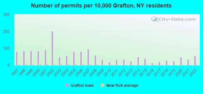
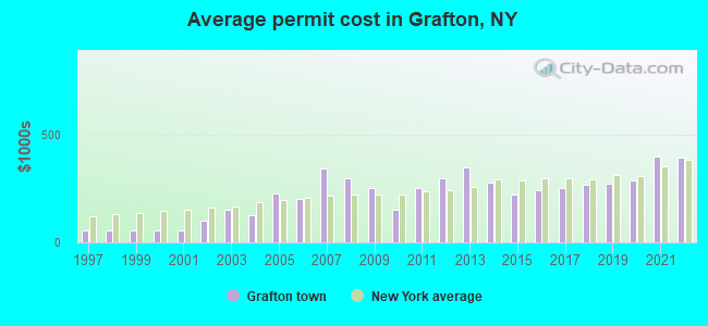
Single-family new house construction building permits:
- 2022: 11 buildings, average cost: $395,900
- 2021: 7 buildings, average cost: $397,800
- 2020: 10 buildings, average cost: $287,500
- 2019: 5 buildings, average cost: $270,000
- 2018: 6 buildings, average cost: $266,700
- 2017: 4 buildings, average cost: $250,000
- 2016: 3 buildings, average cost: $241,700
- 2015: 8 buildings, average cost: $224,100
- 2014: 10 buildings, average cost: $280,000
- 2013: 5 buildings, average cost: $350,000
- 2012: 7 buildings, average cost: $300,000
- 2011: 7 buildings, average cost: $250,000
- 2010: 4 buildings, average cost: $150,000
- 2009: 7 buildings, average cost: $250,000
- 2008: 12 buildings, average cost: $300,000
- 2007: 19 buildings, average cost: $342,100
- 2006: 16 buildings, average cost: $200,000
- 2005: 16 buildings, average cost: $225,000
- 2004: 11 buildings, average cost: $127,300
- 2003: 10 buildings, average cost: $153,100
- 2002: 40 buildings, average cost: $100,000
- 2001: 18 buildings, average cost: $55,500
- 2000: 17 buildings, average cost: $55,500
- 1999: 17 buildings, average cost: $55,500
- 1998: 17 buildings, average cost: $55,500
- 1997: 16 buildings, average cost: $55,500
| Here: | 3.7% |
| New York: | 4.4% |
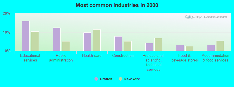
- Educational services (15.9%)
- Public administration (12.4%)
- Health care (9.7%)
- Construction (7.8%)
- Professional, scientific, technical services (4.1%)
- Food & beverage stores (3.3%)
- Accommodation & food services (3.2%)
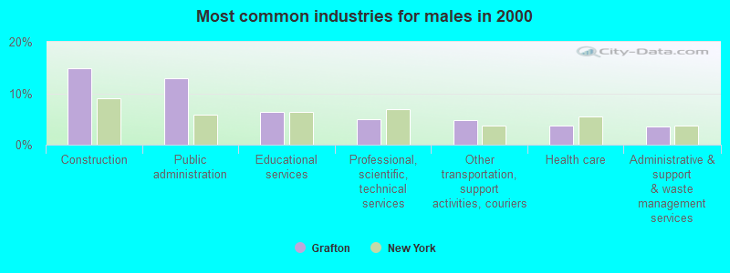
- Construction (14.9%)
- Public administration (12.9%)
- Educational services (6.5%)
- Professional, scientific, technical services (5.0%)
- Other transportation, support activities, couriers (4.8%)
- Health care (3.7%)
- Administrative & support & waste management services (3.5%)
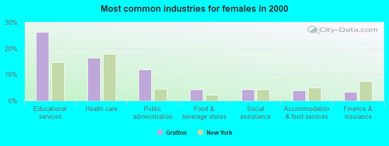
- Educational services (26.2%)
- Health care (16.3%)
- Public administration (11.9%)
- Food & beverage stores (4.2%)
- Social assistance (4.2%)
- Accommodation & food services (3.8%)
- Finance & insurance (3.4%)
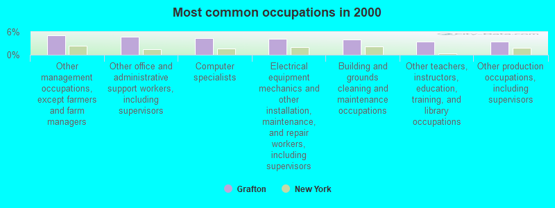
- Other management occupations, except farmers and farm managers (5.0%)
- Other office and administrative support workers, including supervisors (4.8%)
- Computer specialists (4.3%)
- Electrical equipment mechanics and other installation, maintenance, and repair workers, including supervisors (4.1%)
- Building and grounds cleaning and maintenance occupations (4.0%)
- Other teachers, instructors, education, training, and library occupations (3.5%)
- Other production occupations, including supervisors (3.5%)
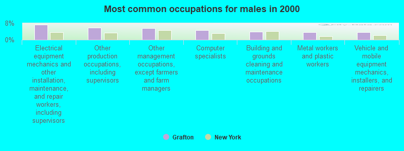
- Electrical equipment mechanics and other installation, maintenance, and repair workers, including supervisors (7.4%)
- Other production occupations, including supervisors (5.9%)
- Other management occupations, except farmers and farm managers (5.5%)
- Computer specialists (4.6%)
- Building and grounds cleaning and maintenance occupations (3.9%)
- Metal workers and plastic workers (3.7%)
- Vehicle and mobile equipment mechanics, installers, and repairers (3.7%)
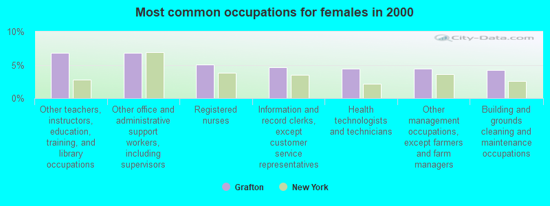
- Other teachers, instructors, education, training, and library occupations (6.9%)
- Other office and administrative support workers, including supervisors (6.9%)
- Registered nurses (5.0%)
- Information and record clerks, except customer service representatives (4.6%)
- Health technologists and technicians (4.4%)
- Other management occupations, except farmers and farm managers (4.4%)
- Building and grounds cleaning and maintenance occupations (4.2%)
Average climate in Grafton, New York
Based on data reported by over 4,000 weather stations


(lower is better)
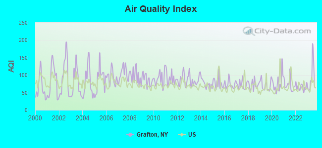
Air Quality Index (AQI) level in 2023 was 89.6. This is worse than average.
| City: | 89.6 |
| U.S.: | 72.6 |
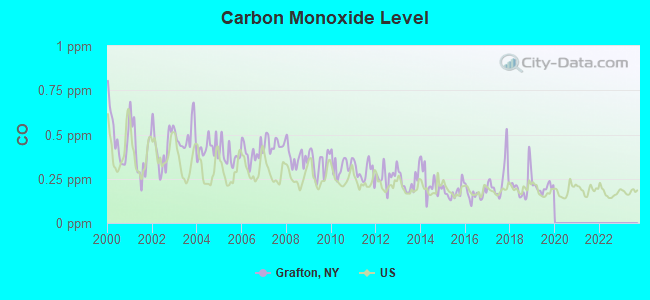
Carbon Monoxide (CO) [ppm] level in 2019 was 0.199. This is better than average. Closest monitor was 16.6 miles away from the city center.
| City: | 0.199 |
| U.S.: | 0.251 |
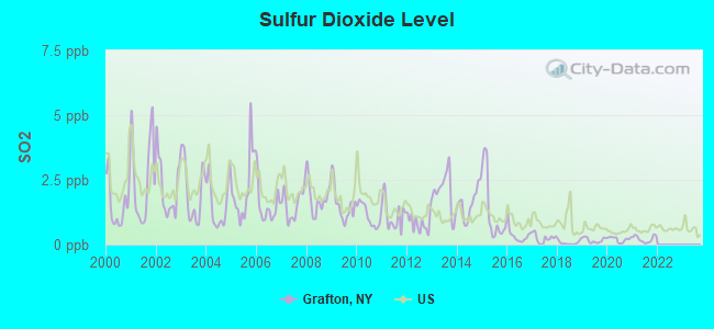
Sulfur Dioxide (SO2) [ppb] level in 2021 was 0.213. This is significantly better than average. Closest monitor was 0.9 miles away from the city center.
| City: | 0.213 |
| U.S.: | 1.515 |
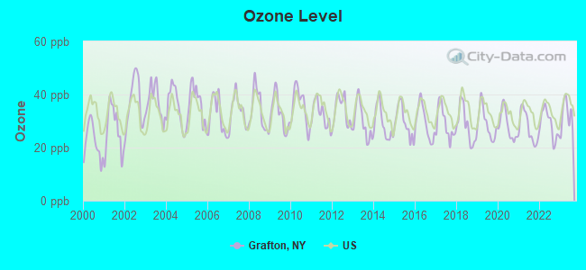
Ozone [ppb] level in 2023 was 32.1. This is about average. Closest monitor was 0.9 miles away from the city center.
| City: | 32.1 |
| U.S.: | 33.3 |
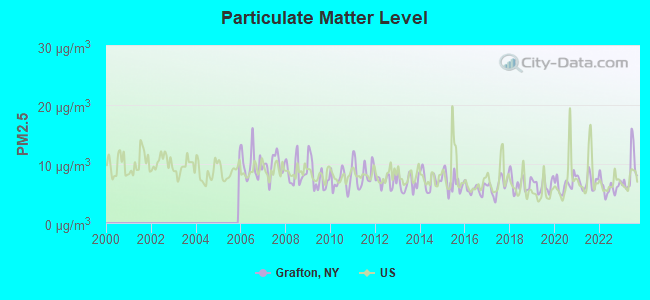
Particulate Matter (PM2.5) [µg/m3] level in 2023 was 8.74. This is about average. Closest monitor was 13.2 miles away from the city center.
| City: | 8.74 |
| U.S.: | 8.11 |
Tornado activity:
Grafton-area historical tornado activity is above New York state average. It is 38% smaller than the overall U.S. average.
On 8/28/1973, a category F4 (max. wind speeds 207-260 mph) tornado 24.3 miles away from the Grafton town center killed 4 people and injured 36 people and caused between $5,000,000 and $50,000,000 in damages.
On 6/24/1960, a category F3 (max. wind speeds 158-206 mph) tornado 17.4 miles away from the town center injured 9 people and caused between $5,000,000 and $50,000,000 in damages.
Earthquake activity:
Grafton-area historical earthquake activity is significantly above New York state average. It is 68% smaller than the overall U.S. average.On 10/7/1983 at 10:18:46, a magnitude 5.3 (5.1 MB, 5.3 LG, 5.1 ML, Class: Moderate, Intensity: VI - VII) earthquake occurred 93.2 miles away from the city center
On 4/20/2002 at 10:50:47, a magnitude 5.3 (5.3 ML, Depth: 3.0 mi) earthquake occurred 121.1 miles away from Grafton center
On 4/20/2002 at 10:50:47, a magnitude 5.2 (5.2 MB, 4.2 MS, 5.2 MW, 5.0 MW) earthquake occurred 119.5 miles away from the city center
On 1/19/1982 at 00:14:42, a magnitude 4.7 (4.5 MB, 4.7 MD, 4.5 LG, Class: Light, Intensity: IV - V) earthquake occurred 106.3 miles away from Grafton center
On 10/16/2012 at 23:12:25, a magnitude 4.7 (4.7 ML, Depth: 10.0 mi) earthquake occurred 152.3 miles away from Grafton center
On 6/17/1991 at 08:53:16, a magnitude 4.1 (4.0 MB, 4.0 LG, Depth: 3.1 mi) earthquake occurred 63.0 miles away from Grafton center
Magnitude types: regional Lg-wave magnitude (LG), body-wave magnitude (MB), duration magnitude (MD), local magnitude (ML), surface-wave magnitude (MS), moment magnitude (MW)
Natural disasters:
The number of natural disasters in Rensselaer County (24) is greater than the US average (15).Major Disasters (Presidential) Declared: 14
Emergencies Declared: 9
Causes of natural disasters: Storms: 7, Floods: 5, Hurricanes: 5, Winter Storms: 4, Blizzards: 2, Snowstorms: 2, Tornadoes: 2, Chemical Waste: 1, Power Outage: 1, Tropical Storm: 1, Other: 2 (Note: some incidents may be assigned to more than one category).
Hospitals and medical centers near Grafton:
- DIAMOND HILL NURSING AND REHABILITATION CENTER (Nursing Home, about 11 miles away; TROY, NY)
- LEONARD HOSPITAL (Hospital, about 11 miles away; TROY, NY)
- EDDY HERITAGE HOUSE NURSING CTR (Nursing Home, about 11 miles away; TROY, NY)
- THE CENTER FOR NURSING AND REHAB AT HOOSICK FALLS (Nursing Home, about 11 miles away; HOOSICK FALLS, NY)
- JAMES A EDDY MEMORIAL GERIATRIC CENTER (Nursing Home, about 12 miles away; TROY, NY)
- SAMARITAN HOSPITAL Acute Care Hospitals (about 12 miles away; TROY, NY)
- H AND L RUBIN DIALYSIS CENTER (Dialysis Facility, about 12 miles away; TROY, NY)
Amtrak station near Grafton:
- 18 miles: ALBANY-RENSSELAER (RENSSELAER, 555 EAST ST.) . Services: ticket office, partially wheelchair accessible, enclosed waiting area, public restrooms, public payphones, snack bar, ATM, free short-term parking, free long-term parking, call for car rental service, taxi stand, public transit connection.
Colleges/universities with over 2000 students nearest to Grafton:
- Rensselaer Polytechnic Institute (about 12 miles; Troy, NY; Full-time enrollment: 6,940)
- The Sage Colleges (about 13 miles; Troy, NY; FT enrollment: 2,499)
- Hudson Valley Community College (about 13 miles; Troy, NY; FT enrollment: 9,346)
- Williams College (about 14 miles; Williamstown, MA; FT enrollment: 2,141)
- Siena College (about 16 miles; Loudonville, NY; FT enrollment: 3,153)
- The College of Saint Rose (about 19 miles; Albany, NY; FT enrollment: 4,085)
- SUNY at Albany (about 20 miles; Albany, NY; FT enrollment: 15,490)
Points of interest:
Notable locations in Grafton: Camp Yowochas (A), Grafton Volunteer Fire Company (B). Display/hide their locations on the map
Churches in Grafton include: Community Church of Grafton (A), Mountain Chapel Church (B), Saint John Francis Regis Catholic Church (C), Grafton United Methodist Church (D). Display/hide their locations on the map
Cemeteries: Bonesteel Cemetery (1), Snyder Cemetery (2). Display/hide their locations on the map
Lakes and reservoirs: Long Pond (A), Peckham Pond (B), Red Pond (C), Second Pond (D), South Long Pond (E), Taconic Pond (F), White Lily Pond (G), Banker Pond (H). Display/hide their locations on the map
Drinking water stations with addresses in Grafton that have no violations reported:
- GRAFTON LAKES STATE PARK (Population served: 2,500, Primary Water Source Type: Groundwater)
| This town: | 2.6 people |
| New York: | 2.6 people |
| This town: | 72.7% |
| Whole state: | 63.5% |
| This town: | 8.8% |
| Whole state: | 6.8% |
Likely homosexual households (counted as self-reported same-sex unmarried-partner households)
- Lesbian couples: 0.6% of all households
- Gay men: 0.5% of all households
| This town: | 6.0% |
| Whole state: | 14.6% |
| This town: | 3.3% |
| Whole state: | 7.4% |
For population 15 years and over in Grafton:
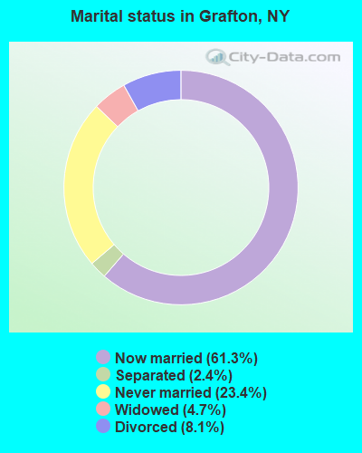
- Never married: 23.4%
- Now married: 61.3%
- Separated: 2.4%
- Widowed: 4.7%
- Divorced: 8.1%
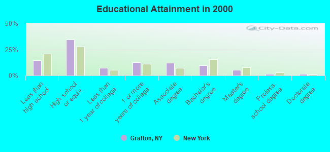
For population 25 years and over in Grafton:
- High school or higher: 85.2%
- Bachelor's degree or higher: 18.6%
- Graduate or professional degree: 8.6%
- Unemployed: 3.6%
- Mean travel time to work (commute): 35.5 minutes
| Here: | 10.9 |
| New York average: | 14.2 |
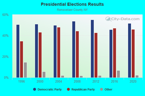

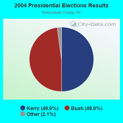
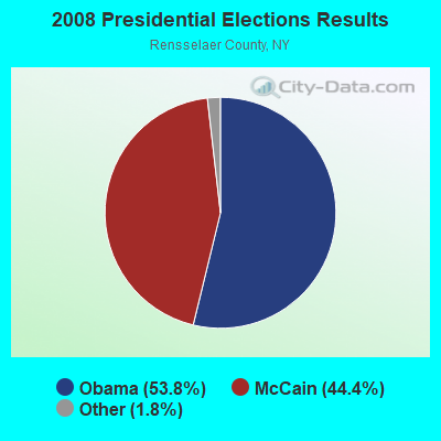
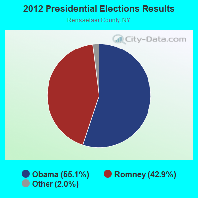
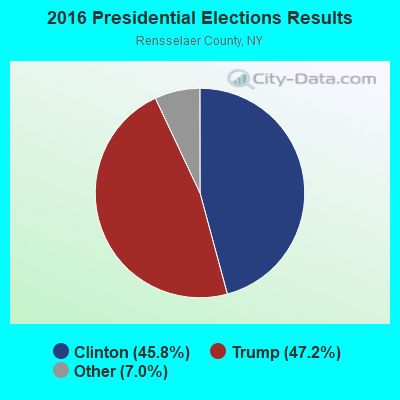
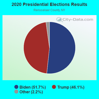
Graphs represent county-level data. Detailed 2008 Election Results
Religion statistics for Grafton, NY (based on Rensselaer County data)
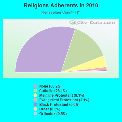
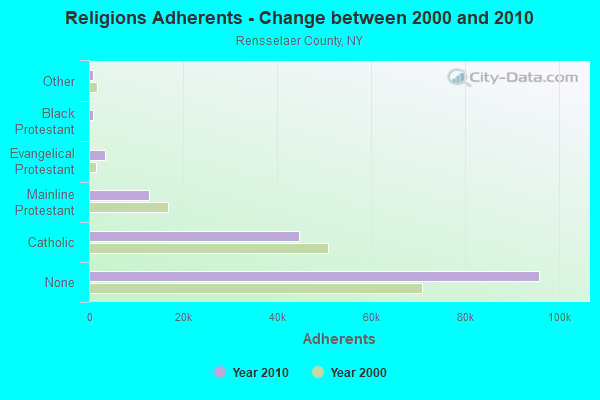
| Religion | Adherents | Congregations |
|---|---|---|
| Catholic | 44,756 | 21 |
| Mainline Protestant | 12,867 | 70 |
| Evangelical Protestant | 3,424 | 37 |
| Black Protestant | 882 | 3 |
| Other | 847 | 12 |
| Orthodox | 740 | 3 |
| None | 95,913 | - |
Food Environment Statistics:
| Rensselaer County: | 2.07 / 10,000 pop. |
| State: | 4.13 / 10,000 pop. |
| Rensselaer County: | 0.84 / 10,000 pop. |
| New York: | 0.92 / 10,000 pop. |
| Rensselaer County: | 3.55 / 10,000 pop. |
| New York: | 1.68 / 10,000 pop. |
| Rensselaer County: | 6.07 / 10,000 pop. |
| New York: | 8.82 / 10,000 pop. |
| This county: | 7.4% |
| New York: | 8.2% |
| This county: | 26.7% |
| State: | 23.8% |
| This county: | 15.4% |
| State: | 15.6% |
Strongest AM radio stations in Grafton:
- WPTR (1540 AM; 50 kW; ALBANY, NY; Owner: KIMTRON, INC.)
- WGY (810 AM; 50 kW; SCHENECTADY, NY; Owner: CLEAR CHANNEL BROADCASTING LICENSES, INC.)
- WNNZ (640 AM; 50 kW; WESTFIELD, MA; Owner: CLEAR CHANNEL BROADCASTING LICENSES, INC.)
- WROW (590 AM; 5 kW; ALBANY, NY; Owner: 6 JOHNSON ROAD LICENSES, INC.)
- WABY (1160 AM; 5 kW; MECHANICVILLE, NY; Owner: ANASTOS MEDIA GROUP, INC.)
- WOFX (980 AM; 5 kW; TROY, NY)
- WTMM (1300 AM; 5 kW; RENSSELAER, NY; Owner: REGENT LICENSEE OF MANSFIELD, INC.)
- WDDY (1460 AM; 5 kW; ALBANY, NY)
- WCRN (830 AM; 50 kW; WORCESTER, MA; Owner: CARTER BROADCASTING CORPORATION)
- WTIC (1080 AM; 50 kW; HARTFORD, CT; Owner: INFINITY RADIO OPERATIONS INC.)
- WUHN (1110 AM; daytime; 5 kW; PITTSFIELD, MA; Owner: WEINER BROADCASTING, INC.)
- WHAZ (1330 AM; 1 kW; TROY, NY; Owner: CAPITAL MEDIA CORPORATION)
- WRKO (680 AM; 50 kW; BOSTON, MA; Owner: ENTERCOM BOSTON LICENSE, LLC)
Strongest FM radio stations in Grafton:
- WZEC (97.5 FM; HOOSICK FALLS, NY; Owner: GREAT NORTHERN RADIO, LLC)
- WAMC-FM (90.3 FM; ALBANY, NY; Owner: WAMC)
- WEQX (102.7 FM; MANCHESTER, VT; Owner: NORTHSHIRE COMMUNICATIONS, INC.)
- WJAN (95.1 FM; SUNDERLAND, VT; Owner: 6 JOHNSON ROAD LICENSES, INC.)
- WVAY (100.7 FM; WILMINGTON, VT; Owner: GREAT NORTHERN RADIO, L.L.C.)
- WNGN (91.9 FM; ARGYLE, NY; Owner: NORTHEAST GOSPEL BROADCASTING INC)
- WAJZ (96.3 FM; VOORHEESVILLE, NY; Owner: 6 JOHNSON ROAD LICENSES, INC.)
- WYJB (95.5 FM; ALBANY, NY; Owner: 6 JOHNSON ROAD LICENSES, INC.)
- WZMR (104.9 FM; ALTAMONT, NY; Owner: 6 JOHNSON ROAD LICENSES, INC.)
- WGNA-FM (107.7 FM; ALBANY, NY; Owner: REGENT LICENSEE OF MANSFIELD, INC.)
- WRPI (91.5 FM; TROY, NY; Owner: RENSSELAER POLYTECHNIC INSTITUTE)
- WRVE (99.5 FM; SCHENECTADY, NY; Owner: CLEAR CHANNEL BROADCASTING LICENSES, INC.)
- WMHT-FM (89.1 FM; SCHENECTADY, NY; Owner: WMHT EDUCATIONAL TELECOMMUNICATIONS)
- WHVP (91.1 FM; HUDSON, NY; Owner: SOUND OF LIFE, INC.)
- WHRL (103.1 FM; ALBANY, NY; Owner: CLEAR CHANNEL BROADCASTING LICENSES, INC.)
- WPYX (106.5 FM; ALBANY, NY; Owner: CAPSTAR TX LIMITED PARTNERSHIP)
- WJJR (98.1 FM; RUTLAND, VT; Owner: 6 JOHNSON ROAD LICENSES, INC.)
- WZRT (97.1 FM; RUTLAND, VT; Owner: CAPSTAR TX LIMITED PARTNERSHIP)
- WVCR-FM (88.3 FM; LOUDONVILLE, NY; Owner: SIENA COLLEGE)
- WFLY (92.3 FM; TROY, NY; Owner: 6 JOHNSON ROAD LICENSES, INC.)
TV broadcast stations around Grafton:
- WNGN-LP (Channel 26; TROY, NY; Owner: BRIAN A. LARSON)
- WRGB (Channel 6; SCHENECTADY, NY; Owner: FREEDOM BROADCASTING OF NEW YORK, INC)
- WNYT (Channel 13; ALBANY, NY; Owner: WNYT-TV, LLC)
- WNYA-CA (Channel 39; EASTON, ETC., NY; Owner: VENTURE TECHNOLOGIES GROUP, LLC)
- WTEN (Channel 10; ALBANY, NY; Owner: YOUNG BROADCASTING OF ALBANY, INC.)
- WEWB-TV (Channel 45; SCHENECTADY, NY; Owner: WEWB, L.L.C.)
- WMHT (Channel 17; SCHENECTADY, NY; Owner: WMHT EDUCATIONAL TELECOMMUNICATIONS)
- WCDC-TV (Channel 19; ADAMS, MA; Owner: YOUNG BROADCASTING OF ALBANY, INC.)
- W38DL (Channel 38; ADAMS, ETC., MA; Owner: WNYT-TV, LLC)
Grafton fatal accident list:
Jun 25, 2006 12:50 AM, Sr-2, Dumbleton, Lat: 42.769960, Lon: -73.461710, Vehicles: 1, Persons: 1, Fatalities: 1
Jun 28, 2003 09:13 PM, Kautz Hollow Rd, Vehicles: 1, Persons: 2, Fatalities: 1
Aug 7, 2001 07:51 PM, Sr-2, Vehicles: 2, Persons: 7, Fatalities: 1
Nov 16, 1999 05:30 PM, Cr-97, Vehicles: 1, Persons: 2, Pedestrians: 1, Fatalities: 1
Oct 21, 1999 08:03 AM, Sr-2, Vehicles: 2, Persons: 2, Fatalities: 1
Nov 21, 1997 06:07 PM, 2, Vehicles: 1, Persons: 4, Fatalities: 1
- National Bridge Inventory (NBI) Statistics
- 1Number of bridges
- 7ft / 1.8mTotal length
- $1,600,000Total costs
- 4,920Total average daily traffic
- 836Total average daily truck traffic
- 5,247Total future (year 2040) average daily traffic
FCC Registered Antenna Towers:
4- John M Maddalla, Dyken Pond Rd (Lat: 42.732222 Lon: -73.507500), Type: 55.0, Structure height: 36083 m, Overall height: 52 m, Registrant: Business Radio Communications Inc., Radiowizzz@aol.Com, , 368 Renss-elear, Phone: (518) 465-8296
- Tom Diederich, Dyken Pond Rd (Lat: 42.732222 Lon: -73.507500), Type: 55.0, Structure height: 36083 m, Overall height: 52 m, Registrant: Algonquin Communications, Algnquin@nycap.Rr.Com, , Wynan-tskill, Phone: (518) 857-6792
- Dyken Pond Rd (Lat: 42.732222 Lon: -73.507500), Type: 55.0, Overall height: 52 m, Registrant: Business Radio Communications Inc, Renss-elaer, Phone: (518) 283-0958
- East End Snyder Road (Lat: 42.745833 Lon: -73.445556), Type: 51.0, Overall height: 46 m, Registrant: Albany Communications & Microwave, Radioservice@albanycom.Com, , Alban-y, Phone: (800) 535-0232
FCC Registered Broadcast Land Mobile Towers:
7- GRAFTON MOUNTAIN, South Road (Lat: 42.746472 Lon: -73.445028), Type: Gtower, Structure height: 49 m, Overall height: 55 m, Call Sign: KEH414,
Assigned Frequencies: 154.160 MHz, 158.760 MHz, 155.745 MHz, 155.947 MHz, Grant Date: 07/21/2021, Expiration Date: 10/14/2031, Registrant: Washington County Department Of Public Safety, 383 Broadway, Fort Edward, NY 12828, Phone: (518) 747-7520, Fax: (518) 746-2157, Email:
- Rt 2 2 Mi E Of Int Rt 85 (Lat: 42.769528 Lon: -73.447056), Call Sign: WNPB812,
Assigned Frequencies: 46.1000 MHz, Grant Date: 02/28/2024, Expiration Date: 04/10/2034, Registrant: Grafton Fire Dept, 504 South Rd, Cropseyville, NY 12052, Phone: (518) 279-3670
- Dickinson Hill (Lat: 42.793417 Lon: -73.414000), Call Sign: KED923,
Assigned Frequencies: 42.1400 MHz, 155.370 MHz, 154.665 MHz, 155.475 MHz, 154.680 MHz, 154.695 MHz, 155.445 MHz, 155.565 MHz, Grant Date: 11/27/2021, Expiration Date: 02/19/2032, Registrant: New York State Police, 1220 Washington Ave, Bldg 22, Albany, NY 12226-2252, Phone: (518) 457-9466, Fax: (518) 457-5676, Email:
- E End Snyder Rd (Lat: 42.745083 Lon: -73.445667), Type: Tower, Structure height: 37 m, Call Sign: WNQZ421, Licensee ID: L00011680,
Assigned Frequencies: 157.740 MHz, Grant Date: 04/21/2000, Expiration Date: 04/21/2005, Cancellation Date: 06/25/2005, Certifier: James R Loder, Registrant: Central Vermont Communications, 13 Us Rte 4, Rutland, VT 05701, Phone: (518) 475-0065
- Davitts Pond Rd (Lat: 42.714250 Lon: -73.527056), Type: Tower, Structure height: 30.5 m, Overall height: 35.4 m, Call Sign: KEG493,
Assigned Frequencies: 451.375 MHz, 153.575 MHz, 153.605 MHz, 47.8200 MHz, 153.440 MHz, 153.515 MHz, 153.545 MHz, 158.130 MHz, 451.125 MHz, 451.200 MHz, 153.605 MHz, Grant Date: 03/17/2023, Expiration Date: 05/11/2033, Certifier: Chris Kelly, Registrant: Utilities Technology Council, 2550 South Clark St., Suite 960, Arlington, VA 22202, Phone: (202) 833-6818, Email:
- Lat: 42.746472 Lon: -73.445111, Call Sign: WPWY908,
Assigned Frequencies: 853.862 MHz, 853.887 MHz, 853.912 MHz, 853.987 MHz, Grant Date: 12/23/2022, Expiration Date: 02/12/2033, Certifier: Kelly Paslow, Registrant: Algonquin Communications, 434 West Sand Lake Road, Wynantskill, NY 12198, Phone: (518) 857-6792, Email:
- 2 Tower Way Rd (Lat: 42.746000 Lon: -73.445472), Type: Tower, Structure height: 54.8 m, Overall height: 57.9 m, Call Sign: WQOU272,
Assigned Frequencies: 457.025 MHz, Grant Date: 01/31/2012, Expiration Date: 01/31/2022, Cancellation Date: 04/02/2022, Certifier: Roderick J Valente, Registrant: Wells Communication Svc., Inc., 221 N. Greenbush Rd., Troy, NY 12180, Phone: (518) 283-2735, Fax: (518) 283-0901, Email:
FCC Registered Microwave Towers:
3- STATION, South Rd 2 Mi 1/4 Mi E Of (Lat: 42.746444 Lon: -73.445111), Overall height: 48.8 m, Call Sign: WNEL265,
Assigned Frequencies: 2136.40 MHz, Grant Date: 06/10/1997, Expiration Date: 08/06/2002, Cancellation Date: 11/10/2002, Phone: (518) 283-2735
- Grafton, South Road, 2 Mi Ne Of (Lat: 42.746444 Lon: -73.445111), Type: Tower, Structure height: 60 m, Call Sign: WPXL327,
Assigned Frequencies: 10623.7 MHz, Grant Date: 04/11/2023, Expiration Date: 04/28/2033, Certifier: Kelly Paslow, Registrant: Algonquin Communications, 434 West Sand Lake Road, Wynantskill, NY 12198, Phone: (518) 857-6792, Email:
- STATION, Dickenson Hill (Lat: 42.793556 Lon: -73.413722), Type: Gtower, Structure height: 42.7 m, Overall height: 45.7 m, Call Sign: WIR31,
Assigned Frequencies: 6795.00 MHz, Grant Date: 03/05/2021, Expiration Date: 05/30/2031, Registrant: Acd Telecom, 103 Commerce Street, Suite 180, Lake Mary, FL 32746, Phone: (407) 333-2300, Email:
FCC Registered Amateur Radio Licenses:
3- Call Sign: KA2SKG, Grant Date: 05/26/1995, Expiration Date: 05/26/2005, Cancellation Date: 05/27/2007, Registrant: Charles H Kenna, Grafton, NY 12082-0026
- Call Sign: N2ZKZ, Licensee ID: L00887553, Grant Date: 07/09/2014, Expiration Date: 07/13/2024, Certifier: Owen J Grandjean, Registrant: Owen J Grandjean, Box 59 Rt 2, Grafton, NY 12082
- Call Sign: WB2DST, Grant Date: 09/13/1995, Expiration Date: 09/13/2005, Cancellation Date: 09/14/2007, Registrant: Richard M Crossett, Grafton, NY 12082
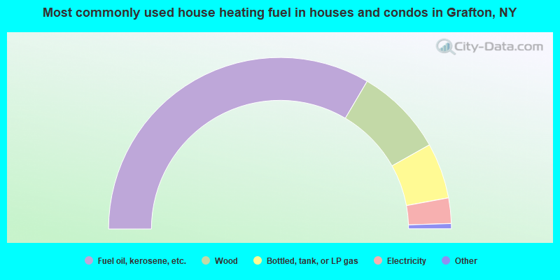
- 67.0%Fuel oil, kerosene, etc.
- 16.7%Wood
- 10.5%Bottled, tank, or LP gas
- 4.8%Electricity
- 0.4%Other fuel
- 0.3%Utility gas
- 0.3%Coal or coke
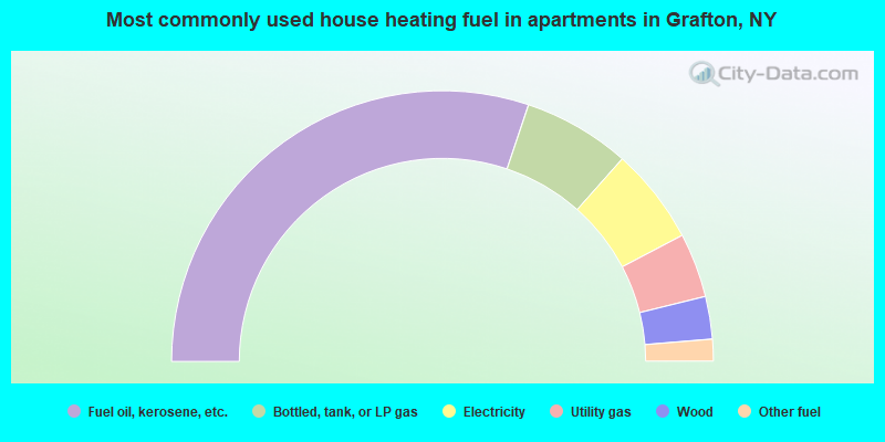
- 60.3%Fuel oil, kerosene, etc.
- 12.8%Bottled, tank, or LP gas
- 11.5%Electricity
- 7.7%Utility gas
- 5.1%Wood
- 2.6%Other fuel
Grafton compared to New York state average:
- Median house value below state average.
- Unemployed percentage significantly below state average.
- Black race population percentage significantly below state average.
- Hispanic race population percentage significantly below state average.
- Foreign-born population percentage significantly below state average.
- Renting percentage significantly below state average.
- Length of stay since moving in significantly above state average.
- Number of rooms per house significantly below state average.
- House age significantly below state average.
- Percentage of population with a bachelor's degree or higher below state average.