Gosnold, Massachusetts
Submit your own pictures of this town and show them to the world
- OSM Map
- Google Map
- MSN Map
Population change since 2000: -12.8%
 |
| Males: 43 | |
| Females: 32 |
| Median resident age: | 48.5 years |
| Massachusetts median age: | 39.2 years |
Zip code: 02568
| Gosnold: | $44,766 |
| MA: | $94,488 |
Estimated per capita income in 2022: $35,422 (it was $15,265 in 2000)
Estimated median house or condo value in 2022: over $1,000,000 (it was $375,000 in 2000)
| Gosnold: | over $1,000,000 |
| MA: | $534,700 |
Mean prices in 2022: all housing units: over $1,000,000; detached houses: over $1,000,000; townhouses or other attached units: over $1,000,000; in 2-unit structures: $912,859; in 3-to-4-unit structures: $934,263
Detailed information about poverty and poor residents in Gosnold, MA
Compare current foreclosures near Gosnold, MA:
| Photo | Address | Area | Beds / Baths | Price | Details |
|---|---|---|---|---|---|

|
#1
W Falmouth Hwy
Falmouth, MA 02540
|
1,224 sq. feet
|
2 baths 4 beds |
$665,000
|
show details |

|
#2
David St
New Bedford, MA 02744
|
3,360 sq. feet
|
3 baths 9 beds |
show details | |

|
#3
Willis St
New Bedford, MA 02740
|
1,973 sq. feet
|
2 baths 4 beds |
show details | |

|
#4
Oak St
New Bedford, MA 02740
|
1,460 sq. feet
|
2 baths 3 beds |
show details | |

|
#5
Mill St
New Bedford, MA 02740
|
1,542 sq. feet
|
1 baths 3 beds |
show details | |

|
#6
Belleville Rd
New Bedford, MA 02745
|
- sq. feet
|
2 baths 5 beds |
show details | |

|
#7
Homestead Ave
Acushnet, MA 02743
|
936 sq. feet
|
1 baths 3 beds |
show details | |

|
#8
Willis St
New Bedford, MA 02740
|
1,555 sq. feet
|
1 baths 4 beds |
show details | |

|
#9
Morton St
Fairhaven, MA 02719
|
1,041 sq. feet
|
1 baths 3 beds |
show details | |

|
#10
Main St
Fairhaven, MA 02719
|
2,686 sq. feet
|
2 baths 6 beds |
show details |
| Photo | Address | Area | Beds / Baths | Price | Details |
|---|---|---|---|---|---|

|
#11
Lils Way
Mattapoisett, MA 02739
|
1,404 sq. feet
|
1 baths 3 beds |
show details | |

|
#12
Nobska Rd
Woods Hole, MA 02543
|
1,384 sq. feet
|
2 baths 3 beds |
show details | |

|
#13
Woodcock Rd
North Dartmouth, MA 02747
|
1,866 sq. feet
|
3 baths 3 beds |
show details | |

|
#14
Alden Rd
Fairhaven, MA 02719
|
2,559 sq. feet
|
3 baths 2 beds |
show details | |

|
#15
Park St
New Bedford, MA 02740
|
1,056 sq. feet
|
1 baths 2 beds |
show details | |

|
#16
Locust St
New Bedford, MA 02740
|
759 sq. feet
|
1 baths 2 beds |
show details | |

|
#17
Richmond St
New Bedford, MA 02740
|
1,952 sq. feet
|
1 baths 5 beds |
show details | |

|
#18
Ashland Pl
New Bedford, MA 02740
|
1,228 sq. feet
|
2 baths 3 beds |
show details | |

|
#19
Fordham Cir
East Falmouth, MA 02536
|
1,784 sq. feet
|
1 baths 3 beds |
show details | |

|
#20
Austin St # 1
New Bedford, MA 02740
|
2,540 sq. feet
|
2 baths 6 beds |
show details |
| Photo | Address | Area | Beds / Baths | Price | Details |
|---|---|---|---|---|---|

|
#21
Tenley Ave
North Dartmouth, MA 02747
|
960 sq. feet
|
1 baths 3 beds |
show details | |

|
#22
Taber St
Fairhaven, MA 02719
|
650 sq. feet
|
1 baths 3 beds |
show details | |

|
#23
Reed St
New Bedford, MA 02740
|
1,742 sq. feet
|
1 baths 4 beds |
show details | |

|
#24
Clark St
New Bedford, MA 02740
|
1,160 sq. feet
|
1 baths 3 beds |
show details | |

|
#25
Willis St
New Bedford, MA 02740
|
1,879 sq. feet
|
2 baths 5 beds |
show details | |

|
#26
Chancery St
New Bedford, MA 02740
|
1,327 sq. feet
|
1 baths 3 beds |
show details | |

|
#27
County St
New Bedford, MA 02740
|
2,624 sq. feet
|
4 baths 4 beds |
show details | |

|
#28
Bailey Park Rd
Vineyard Haven, MA 02568
|
1,267 sq. feet
|
2 baths 3 beds |
show details | |

|
#29
Wood St
Fairhaven, MA 02719
|
1,944 sq. feet
|
2 baths 5 beds |
show details | |

|
#30
Rounds St
New Bedford, MA 02740
|
1,450 sq. feet
|
1 baths 4 beds |
show details |
| Photo | Address | Area | Beds / Baths | Price | Details |
|---|---|---|---|---|---|

|
#31
Alder Berry Ln
Mattapoisett, MA 02739
|
2,935 sq. feet
|
2 baths 4 beds |
show details | |

|
#32
Chestnut St
New Bedford, MA 02740
|
2,860 sq. feet
|
2 baths 4 beds |
show details | |

|
#33
Hedge St
Fairhaven, MA 02719
|
878 sq. feet
|
1 baths 2 beds |
show details | |

|
#34
Slocum Rd
North Dartmouth, MA 02747
|
1,722 sq. feet
|
2 baths 4 beds |
show details | |

|
#35
Arnold St
New Bedford, MA 02740
|
1,590 sq. feet
|
1 baths 3 beds |
show details | |

|
#36
Ocean St
New Bedford, MA 02740
|
2,240 sq. feet
|
2 baths 4 beds |
show details | |

|
#37
Main St
Fairhaven, MA 02719
|
2,412 sq. feet
|
2 baths 4 beds |
show details | |

|
#38
Summer St
New Bedford, MA 02740
|
2,490 sq. feet
|
2 baths 5 beds |
show details | |

|
#39
Mount Vernon St
New Bedford, MA 02740
|
1,640 sq. feet
|
1 baths 3 beds |
show details | |

|
#40
Mitchell St
New Bedford, MA 02746
|
3,198 sq. feet
|
3 baths 6 beds |
show details |
| Photo | Address | Area | Beds / Baths | Price | Details |
|---|---|---|---|---|---|

|
#41
Felton St
New Bedford, MA 02745
|
1,530 sq. feet
|
1 baths 3 beds |
show details | |

|
#42
Geraldine St
New Bedford, MA 02740
|
1,120 sq. feet
|
1 baths 2 beds |
show details | |

|
#43
Eddy St
North Dartmouth, MA 02747
|
1,294 sq. feet
|
1 baths 3 beds |
show details | |

|
#44
Brooklawn Ct
New Bedford, MA 02745
|
1,160 sq. feet
|
1 baths 3 beds |
show details | |

|
#45
Clifford St
New Bedford, MA 02745
|
2,746 sq. feet
|
2 baths 6 beds |
show details | |

|
#46
Milford St
New Bedford, MA 02745
|
1,186 sq. feet
|
1 baths 3 beds |
show details | |

|
#47
Alfred St
New Bedford, MA 02745
|
2,016 sq. feet
|
2 baths 5 beds |
show details | |

|
#48
Ohio St
New Bedford, MA 02745
|
1,459 sq. feet
|
1 baths 3 beds |
show details | |

|
#49
Irvington St
New Bedford, MA 02745
|
2,648 sq. feet
|
2 baths 5 beds |
show details | |

|
Check over 1 million property listings on Foreclosure.com!
|
browse all offers | |||

- 7296.0%White alone
- 34.0%Two or more races

 Recent articles from our blog. Our writers, many of them Ph.D. graduates or candidates, create easy-to-read articles on a wide variety of topics.
Ancestries: English (37.2%), French (15.1%), German (10.5%), Irish (10.5%), Dutch (9.3%), Scotch-Irish (8.1%).
Current Local Time: EST time zone
Incorporated in 1864
Land area: 13.3 square miles.
Population density: 5.6 people per square mile (very low).
| Gosnold town: | 0.1% ($560) |
| Massachusetts: | 1.3% ($2,336) |
Nearest city with pop. 50,000+: New Bedford, MA  (14.9 miles , pop. 93,768).
Nearest city with pop. 200,000+: Boston, MA (60.6 miles , pop. 589,141).
Nearest city with pop. 1,000,000+: Bronx, NY (168.1 miles , pop. 1,332,650).
Nearest cities:
), ), )Latitude: 41.48 N, Longitude: 70.76 W
Area code commonly used in this area: 508

Single-family new house construction building permits:
- 2015: 1 building, cost: $350,000
- 2014: 1 building, cost: $350,000
- 2007: 1 building, cost: $420,000
- 2006: 1 building, cost: $700,000
- 2004: 2 buildings, average cost: $262,500
- 2003: 2 buildings, average cost: $262,500
- 2002: 2 buildings, average cost: $262,500
- 2001: 2 buildings, average cost: $262,500
- 2000: 1 building, cost: $250,000


| Here: | 0.0% |
| Massachusetts: | 3.5% |

Average climate in Gosnold, Massachusetts
Based on data reported by over 4,000 weather stations


(lower is better)

Air Quality Index (AQI) level in 2022 was 51.5. This is significantly better than average.
| City: | 51.5 |
| U.S.: | 72.6 |


Ozone [ppb] level in 2022 was 33.5. This is about average. Closest monitor was 10.6 miles away from the city center.
| City: | 33.5 |
| U.S.: | 33.3 |
Earthquake activity:
Gosnold-area historical earthquake activity is significantly above Massachusetts state average. It is 76% smaller than the overall U.S. average.On 10/7/1983 at 10:18:46, a magnitude 5.3 (5.1 MB, 5.3 LG, 5.1 ML, Class: Moderate, Intensity: VI - VII) earthquake occurred 249.8 miles away from Gosnold center
On 4/20/2002 at 10:50:47, a magnitude 5.3 (5.3 ML, Depth: 3.0 mi) earthquake occurred 257.0 miles away from Gosnold center
On 8/22/1992 at 12:20:32, a magnitude 4.8 (4.8 MB, 3.8 MS, 4.7 LG, Depth: 6.2 mi, Class: Light, Intensity: IV - V) earthquake occurred 165.9 miles away from Gosnold center
On 1/19/1982 at 00:14:42, a magnitude 4.7 (4.5 MB, 4.7 MD, 4.5 LG) earthquake occurred 146.1 miles away from the city center
On 10/16/2012 at 23:12:25, a magnitude 4.7 (4.7 ML, Depth: 10.0 mi) earthquake occurred 146.4 miles away from the city center
On 4/20/2002 at 10:50:47, a magnitude 5.2 (5.2 MB, 4.2 MS, 5.2 MW, 5.0 MW) earthquake occurred 256.2 miles away from Gosnold center
Magnitude types: regional Lg-wave magnitude (LG), body-wave magnitude (MB), duration magnitude (MD), local magnitude (ML), surface-wave magnitude (MS), moment magnitude (MW)
Natural disasters:
The number of natural disasters in Dukes County (19) is greater than the US average (15).Major Disasters (Presidential) Declared: 11
Emergencies Declared: 7
Causes of natural disasters: Hurricanes: 7, Floods: 4, Storms: 4, Snowstorms: 3, Blizzards: 2, Snows: 2, Winter Storms: 2, Snowfall: 1, Tropical Storm: 1, Wind: 1, Other: 1 (Note: some incidents may be assigned to more than one category).
Hospitals and medical centers near Gosnold:
- JML CARE CENTER INC (Nursing Home, about 10 miles away; FALMOUTH, MA)
- VNA OF UPPER CAPE COD INC (Home Health Center, about 10 miles away; FALMOUTH, MA)
- FALMOUTH NURSING HOME (Nursing Home, about 10 miles away; FALMOUTH, MA)
- ROYAL NURSING CENTER, LLC (Nursing Home, about 10 miles away; FALMOUTH, MA)
- COLONIAL CARE CERTIFIED, INC (Home Health Center, about 10 miles away; FALMOUTH, MA)
- FALMOUTH CARE AND REHABILITATION CENTER (Nursing Home, about 10 miles away; FALMOUTH, MA)
- BARNSTABLE COUNTY HOSPITAL (Hospital, about 11 miles away; POCASSET, MA)
Airports and heliports located in Gosnold:
- Canapitsit Airport (15MA) (Runways: 1)
- Cuttyhunk Heliport (02MA)
Colleges/universities with over 2000 students nearest to Gosnold:
- University of Massachusetts-Dartmouth (about 17 miles; North Dartmouth, MA; Full-time enrollment: 7,545)
- Bristol Community College (about 26 miles; Fall River, MA; FT enrollment: 5,707)
- Cape Cod Community College (about 27 miles; West Barnstable, MA; FT enrollment: 2,491)
- Salve Regina University (about 29 miles; Newport, RI; FT enrollment: 2,349)
- Roger Williams University (about 29 miles; Bristol, RI; FT enrollment: 4,375)
- Bridgewater State University (about 37 miles; Bridgewater, MA; FT enrollment: 9,802)
- University of Rhode Island (about 40 miles; Kingston, RI; FT enrollment: 14,656)
Points of interest:
Notable locations in Gosnold: Tarpaulin Cove Light (A), Cuttyhunk Light (B), Cuttyhunk Harbor North Jetty Light (C), Gosnold Fire Department (D). Display/hide their locations on the map
Lakes and swamps: Middle Pond (A), Duck Pond (B), Crane Pond (C), Marys Lake (D), Fresh Water Pond (E), Westend Pond (F), Quicks Hole Pond (G), Blaney Pond (H). Display/hide their locations on the map
Beaches: West Beach (A), Silver Beach (B), Crescent Beach (C). Display/hide their locations on the map
Drinking water stations with addresses in Gosnold that have no violations reported:
- GOSNOLD WATER DEPT (Population served: 425, Primary Water Source Type: Groundwater)
| This town: | 1.9 people |
| Massachusetts: | 2.5 people |
| This town: | 53.8% |
| Whole state: | 63.0% |
| This town: | 2.6% |
| Whole state: | 7.0% |
No gay or lesbian households reported
| This town: | 23.5% |
| Whole state: | 9.3% |
| This town: | 8.6% |
| Whole state: | 4.4% |
For population 15 years and over in Gosnold:

- Never married: 28.6%
- Now married: 57.1%
- Separated: 3.2%
- Widowed: 9.5%
- Divorced: 1.6%
For population 25 years and over in Gosnold:
- High school or higher: 94.8%
- Bachelor's degree or higher: 20.7%
- Graduate or professional degree: 5.2%
- Mean travel time to work (commute): 3.5 minutes


| Here: | 8.1 |
| Massachusetts average: | 13.1 |
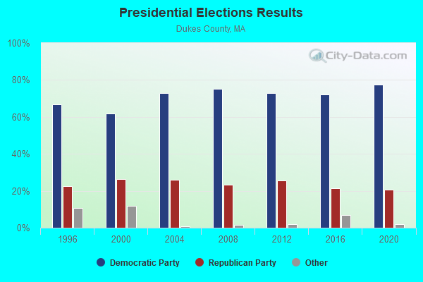
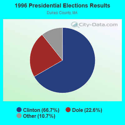
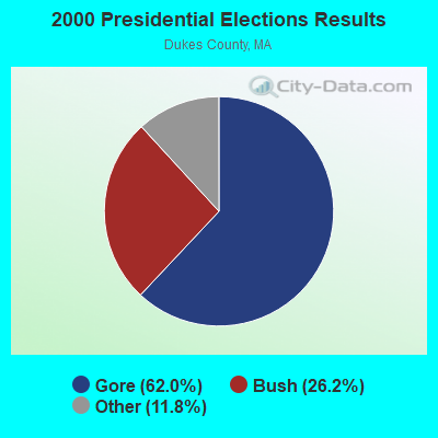
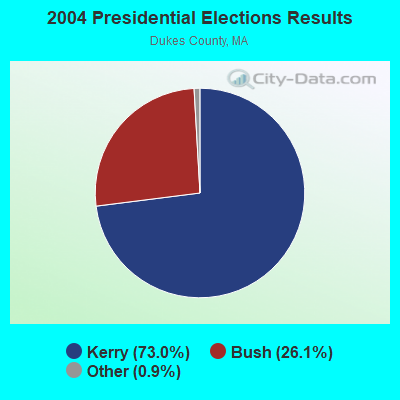
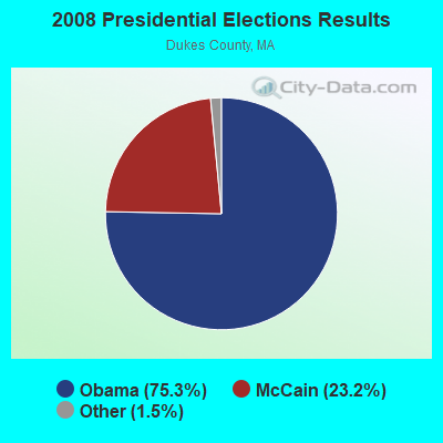
Graphs represent county-level data. Detailed 2008 Election Results
Religion statistics for Gosnold, MA (based on Dukes County data)
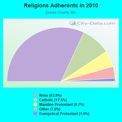
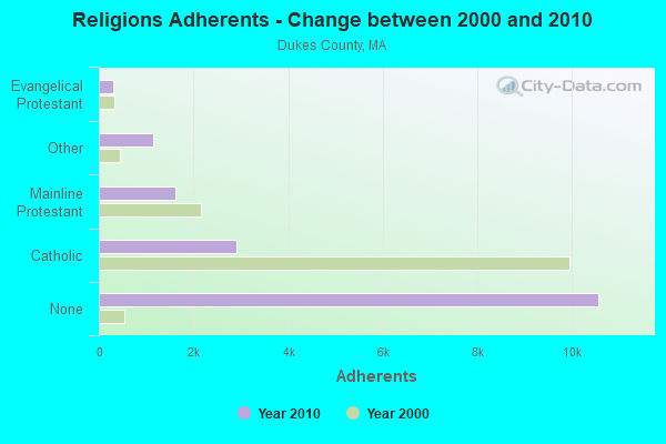
| Religion | Adherents | Congregations |
|---|---|---|
| Catholic | 2,896 | 1 |
| Mainline Protestant | 1,610 | 12 |
| Other | 1,157 | 6 |
| Evangelical Protestant | 310 | 3 |
| None | 10,562 | - |
Food Environment Statistics:
| Dukes County: | 8.41 / 10,000 pop. |
| Massachusetts: | 1.98 / 10,000 pop. |
| Dukes County: | 1.94 / 10,000 pop. |
| Massachusetts: | 2.22 / 10,000 pop. |
| Dukes County: | 1.94 / 10,000 pop. |
| State: | 1.77 / 10,000 pop. |
| Dukes County: | 35.59 / 10,000 pop. |
| Massachusetts: | 8.76 / 10,000 pop. |
| Here: | 8.1% |
| State: | 8.1% |
| Dukes County: | 19.1% |
| Massachusetts: | 22.5% |
| Dukes County: | 14.6% |
| State: | 16.5% |
Strongest AM radio stations in Gosnold:
- WBSM (1420 AM; 5 kW; NEW BEDFORD, MA; Owner: CITADEL BROADCASTING COMPANY)
- WALE (990 AM; 50 kW; GREENVILLE, RI; Owner: NORTH AMERICAN BROADCASTING CO., INC.)
- WBZ (1030 AM; 50 kW; BOSTON, MA; Owner: INFINITY BROADCASTING OPERATIONS, INC.)
- WEEI (850 AM; 50 kW; BOSTON, MA; Owner: ENTERCOM BOSTON LICENSE, LLC)
- WRKO (680 AM; 50 kW; BOSTON, MA; Owner: ENTERCOM BOSTON LICENSE, LLC)
- WKOX (1200 AM; 50 kW; FRAMINGHAM, MA; Owner: CAPSTAR TX LIMITED PARTNERSHIP)
- WCRN (830 AM; 50 kW; WORCESTER, MA; Owner: CARTER BROADCASTING CORPORATION)
- WBIX (1060 AM; 40 kW; NATICK, MA; Owner: LANGER BROADCASTING CORPORATION)
- WWZN (1510 AM; 50 kW; BOSTON, MA; Owner: ROSE CITY RADIO CORPORATION)
- WAMG (890 AM; 25 kW; DEDHAM, MA; Owner: MEGA COMMUNICATIONS OF DEDHAM LICENSEE, LLC)
- WPRO (630 AM; 5 kW; PROVIDENCE, RI; Owner: CITADEL BROADCASTING COMPANY)
- WNNZ (640 AM; 50 kW; WESTFIELD, MA; Owner: CLEAR CHANNEL BROADCASTING LICENSES, INC.)
- WNBH (1340 AM; 1 kW; NEW BEDFORD, MA; Owner: HALL COMMUNICATIONS INC.)
Strongest FM radio stations in Gosnold:
- WCAI (90.1 FM; WOODS HOLE, MA; Owner: WGBH EDUCATIONAL FOUNDATION)
- WCIB (101.9 FM; FALMOUTH, MA; Owner: QANTUM OF CAPE COD LICENSE COMPANY, LLC)
- WMVY (92.7 FM; TISBURY, MA; Owner: ARITAUR COMMUNICATIONS, INC.)
- WJFD-FM (97.3 FM; NEW BEDFORD, MA; Owner: EDMUND DINIS, TRUSTEE)
- WCTK (98.1 FM; NEW BEDFORD, MA; Owner: HALL COMMUNICATIONS, INC.)
- WFHN (107.1 FM; FAIRHAVEN, MA; Owner: CITADEL BROADCASTING COMPANY)
- WTWV (101.1 FM; MASHPEE, MA; Owner: BOCH BROADCASTING, L.P.)
- WFPB-FM (91.9 FM; FALMOUTH, MA; Owner: UNIVERSITY OF MASSACHUSETTS)
- WKKB (100.3 FM; MIDDLETOWN, RI; Owner: CITADEL BROADCASTING COMPANY)
- WWBB (101.5 FM; PROVIDENCE, RI; Owner: CLEAR CHANNEL BROADCASTING LICENSES, INC.)
- WSMU-FM (91.1 FM; NORTH DARTMOUTH, MA; Owner: UNIVERSITY OF MASSACHUSETTS)
- WPXC (102.9 FM; HYANNIS, MA; Owner: QANTUM OF CAPE COD LICENSE COMPANY, LLC)
- WQRC (99.9 FM; BARNSTABLE, MA; Owner: SANDAB COMMUNICATION LTD. PNR/SHP II)
- WFHL (88.1 FM; NEW BEDFORD, MA; Owner: NEW BEDFORD CHRISTIAN RADIO, INC.)
TV broadcast stations around Gosnold:
- WLWC (Channel 28; NEW BEDFORD, MA; Owner: C-28 FCC LICENSEE SUBSIDIARY, LLC)
- WLNE-TV (Channel 6; NEW BEDFORD, MA; Owner: FREEDOM BROADCASTING OF SOUTHERN NEW ENGLAND, INC.)
- WNAC-TV (Channel 64; PROVIDENCE, RI; Owner: WNAC, LLC)
- WPRI-TV (Channel 12; PROVIDENCE, RI; Owner: TVL BROADCASTING OF RHODE ISLAND, LLC)
- WWDP (Channel 46; NORWELL, MA; Owner: NORWELL TELEVISION, LLC)
- WJAR (Channel 10; PROVIDENCE, RI; Owner: OUTLET BROADCASTING, INC.)
- WSBE-TV (Channel 36; PROVIDENCE, RI; Owner: RHODE ISLAND PUBLIC TELECOM. AUTHORITY)
- WDPX (Channel 58; VINEYARD HAVEN, MA; Owner: PAXSON BOSTON-68 LICENSE, INC.)
- WMPX-LP (Channel 67; DENNIS, MA; Owner: PAXSON BOSTON-68 LICENSE, INC.)
FCC Registered Broadcast Land Mobile Towers:
1- Cuttyhunk Island (Lat: 41.422611 Lon: -70.929472), Call Sign: KFR685,
Assigned Frequencies: 155.520 MHz, 155.565 MHz, 155.640 MHz, 155.700 MHz, 158.850 MHz, Grant Date: 05/04/2015, Expiration Date: 05/07/2025, Registrant: Barnstable County Sheriff\'s Office, 6000 Sheriff\'s Place, Bourne, MA 02532, Phone: (508) 563-4210, Fax: (508) 563-4288, Email:
FCC Registered Microwave Towers:
3- Cuttyhunk Island, Tower Rd & Broadway (Lat: 41.420500 Lon: -70.933750), Type: Mtower, Structure height: 15.2 m, Call Sign: WQJR996,
Assigned Frequencies: 6093.45 MHz, 11265.0 MHz, Grant Date: 11/09/2018, Expiration Date: 12/09/2028, Certifier: April Yalenezian, Registrant: Verizon New England Inc, 1300 I St., Nw, Suite 500e, Washington, DC 20005, Phone: (617) 733-1049, Email:
- Cuttyhunk Pole, Gosnold Peer (Lat: 41.424167 Lon: -70.923028), Type: Upole, Structure height: 18.2 m, Call Sign: WRED369,
Assigned Frequencies: 10775.0 MHz, Grant Date: 09/24/2019, Expiration Date: 09/24/2029, Certifier: April Yalenezian, Registrant: Verizon New England Inc, 1300 I St., Nw, Suite 500e, Washington, DC 20005, Phone: (617) 733-1049, Email:
- Cuttyhunk, 5 Bayberry Hill Rd (Lat: 41.421278 Lon: -70.932889), Type: Building, Structure height: 8 m, Overall height: 9 m, Call Sign: WRHS887,
Assigned Frequencies: 11485.0 MHz, 11485.0 MHz, 11485.0 MHz, 11485.0 MHz, 11485.0 MHz, 11485.0 MHz, 11485.0 MHz, 11485.0 MHz, Grant Date: 06/10/2020, Expiration Date: 06/10/2030, Certifier: Paul Zimbone, Registrant: Intelpath, Hinsdale, IL 60522, Phone: (312) 841-9188, Email:
FCC Registered Maritime Coast & Aviation Ground Towers:
2- Broadway (Lat: 41.425111 Lon: -70.928639), Type: Building, Overall height: 4 m, Call Sign: KVY637, Licensee ID: L00071925,
Assigned Frequencies: 156.425 MHz, 156.800 MHz, 156.450 MHz, Grant Date: 05/27/2003, Expiration Date: 06/10/2013, Cancellation Date: 08/10/2013, Registrant: Gosnold, Town Of, Cuttyhunk, MA 02713
- Penikese Island (Lat: 41.448444 Lon: -70.921139), Type: Building, Overall height: 9 m, Call Sign: WHV555,
Assigned Frequencies: 156.450 MHz, 156.800 MHz, 157.025 MHz, Grant Date: 01/13/2005, Expiration Date: 02/02/2015, Cancellation Date: 04/04/2015, Registrant: Universal Licensing Service, 3419 Via Lido Suite 609, Newport Beach, CA 92663-3908, Phone: (877) 677-3639, Fax: (949) 723-2025

- 90.0%Fuel oil, kerosene, etc.
- 10.0%Electricity

- 68.0%Fuel oil, kerosene, etc.
- 16.0%Electricity
- 8.0%Bottled, tank, or LP gas
- 8.0%Wood
Gosnold compared to Massachusetts state average:
- Median household income below state average.
- Median house value above state average.
- Unemployed percentage significantly below state average.
- Black race population percentage significantly below state average.
- Hispanic race population percentage significantly below state average.
- Median age significantly above state average.
- Foreign-born population percentage significantly below state average.
- Renting percentage above state average.
- Length of stay since moving in significantly above state average.
- Number of rooms per house significantly below state average.
- House age significantly below state average.
- Number of college students below state average.
- Percentage of population with a bachelor's degree or higher below state average.
Gosnold on our top lists:
- #8 on the list of "Top 101 larger cities with the lowest real estate taxes percentage (population 50,000+)"
- #5 (02568) on the list of "Top 101 zip codes with the largest percentage of taxpayers reporting profit/loss from business in 2012 (pop 5,000+)"
- #59 (02568) on the list of "Top 101 zip codes with the largest percentage of Scottish first ancestries (pop 5,000+)"
- #100 (02568) on the list of "Top 101 zip codes with the largest percentage of Portuguese first ancestries (pop 5,000+)"
- #71 on the list of "Top 101 counties with the highest Ozone (1-hour) air pollution readings in 2012 (ppm)"
- #73 on the list of "Top 101 counties with highest percentage of residents voting for Obama (Democrat) in the 2012 Presidential Election"