Gladel, Colorado
Submit your own pictures of this place and show them to the world
- OSM Map
- General Map
- Google Map
- MSN Map

| Males: 85 | |
| Females: 73 |
| Median resident age: | 46.9 years |
| Colorado median age: | 34.3 years |
Zip code: 81325
| Gladel: | $42,086 |
| CO: | $89,302 |
Estimated per capita income in 2022: $26,591 (it was $16,425 in 2000)
Estimated median house or condo value in 2022: $222,559 (it was $103,600 in 2000)
| Gladel: | $222,559 |
| CO: | $531,100 |
Mean prices in 2022: all housing units: over $1,000,000; detached houses: over $1,000,000; townhouses or other attached units: $996,342; in 2-unit structures: $509,440; in 3-to-4-unit structures: over $1,000,000; in 5-or-more-unit structures: $692,893; mobile homes: $127,087
Detailed information about poverty and poor residents in Gladel, CO


- 11682.3%White alone
- 149.9%Hispanic
- 64.3%Two or more races
- 32.1%American Indian alone
- 21.4%Asian alone

 Recent articles from our blog. Our writers, many of them Ph.D. graduates or candidates, create easy-to-read articles on a wide variety of topics.
Current Local Time: MST time zone
Land area: 543.7 square miles.
Population density: 0.3 people per square mile (very low).

| Gladel CCD: | 0.2% ($200) |
| Colorado: | 0.7% ($1,132) |
Nearest city with pop. 50,000+: Provo, UT  (215.8 miles , pop. 105,166).
Nearest city with pop. 200,000+: Colorado Springs, CO (226.3 miles , pop. 360,890).
Nearest city with pop. 1,000,000+: Phoenix, AZ (360.5 miles , pop. 1,321,045).
Nearest cities:
), Latitude: 38.03 N, Longitude: 108.83 W
Area code commonly used in this area: 970


| Here: | 3.1% |
| Colorado: | 3.2% |

- Agriculture, forestry, fishing & hunting (25.0%)
- Educational services (11.1%)
- Accommodation & food services (8.3%)
- Mining, quarrying, oil & gas extraction (6.9%)
- Construction (6.9%)
- Department & other general merchandise stores (6.9%)
- Fuel dealers (6.9%)

- Agriculture, forestry, fishing & hunting (36.4%)
- Mining, quarrying, oil & gas extraction (11.4%)
- Construction (11.4%)
- Department & other general merchandise stores (11.4%)
- Arts, entertainment, recreation (9.1%)
- Paper (4.5%)
- Motor vehicle & parts dealers (4.5%)

- Educational services (21.4%)
- Accommodation & food services (21.4%)
- U. S. Postal service (14.3%)
- Food (10.7%)
- Fuel dealers (10.7%)
- Agriculture, forestry, fishing & hunting (7.1%)
- Real estate & rental & leasing (7.1%)

- Farmers and farm managers (18.1%)
- Other management occupations, except farmers and farm managers (6.9%)
- Material recording, scheduling, dispatching, and distributing workers (6.9%)
- Agricultural workers, including supervisors (6.9%)
- Postsecondary teachers (5.6%)
- Supervisors and other personal care and service workers, except child care workers (5.6%)
- Cooks and food preparation workers (4.2%)

- Farmers and farm managers (29.5%)
- Supervisors and other personal care and service workers, except child care workers (9.1%)
- Other management occupations, except farmers and farm managers (6.8%)
- Building and grounds cleaning and maintenance occupations (6.8%)
- Material recording, scheduling, dispatching, and distributing workers (6.8%)
- Agricultural workers, including supervisors (6.8%)
- Carpenters (6.8%)

- Accountants and auditors (10.7%)
- Cooks and food preparation workers (10.7%)
- Financial clerks, except bookkeeping, accounting and auditing clerks (10.7%)
- Food processing workers (10.7%)
- Preschool, kindergarten, elementary, and middle school teachers (7.1%)
- Registered nurses (7.1%)
- Postsecondary teachers (7.1%)
Average climate in Gladel, Colorado
Based on data reported by over 4,000 weather stations


Earthquake activity:
Gladel-area historical earthquake activity is significantly above Colorado state average. It is 1543% greater than the overall U.S. average.On 8/18/1959 at 06:37:13, a magnitude 7.7 (7.7 UK, Class: Major, Intensity: VIII - XII) earthquake occurred 462.1 miles away from Gladel center, causing $26,000,000 total damage
On 10/3/1915 at 06:52:48, a magnitude 7.6 (7.6 UK) earthquake occurred 494.5 miles away from the city center
On 6/28/1992 at 11:57:34, a magnitude 7.6 (6.2 MB, 7.6 MS, 7.3 MW, Depth: 0.7 mi) earthquake occurred 505.5 miles away from Gladel center, causing 3 deaths (1 shaking deaths, 2 other deaths) and 400 injuries, causing $100,000,000 total damage and $40,000,000 insured losses
On 10/16/1999 at 09:46:44, a magnitude 7.4 (6.3 MB, 7.4 MS, 7.2 MW, 7.3 ML) earthquake occurred 488.4 miles away from the city center
On 10/28/1983 at 14:06:06, a magnitude 7.3 (6.2 MB, 7.3 MS, 7.0 MW) earthquake occurred 492.0 miles away from the city center, causing 2 deaths (2 shaking deaths) and 3 injuries, causing $15,000,000 total damage
On 9/2/1992 at 10:26:20, a magnitude 5.9 (5.7 MB, 5.6 MS, 5.6 MW, 5.9 ML, Depth: 9.3 mi, Class: Moderate, Intensity: VI - VII) earthquake occurred 263.7 miles away from Gladel center
Magnitude types: body-wave magnitude (MB), local magnitude (ML), surface-wave magnitude (MS), moment magnitude (MW)
Natural disasters:
The number of natural disasters in San Miguel County (8) is smaller than the US average (15).Major Disasters (Presidential) Declared: 4
Emergencies Declared: 2
Causes of natural disasters: Floods: 3, Fires: 2, Landslides: 2, Drought: 1, Heavy Rain: 1, Hurricane: 1, Mudslide: 1, Storm: 1, Other: 1 (Note: some incidents may be assigned to more than one category).
Colleges/universities with over 2000 students nearest to Gladel:
- Fort Lewis College (about 75 miles; Durango, CO; Full-time enrollment: 3,631)
- Colorado Mesa University (about 75 miles; Grand Junction, CO; FT enrollment: 7,671)
- San Juan College (about 95 miles; Farmington, NM; FT enrollment: 5,112)
- Western State Colorado University (about 110 miles; Gunnison, CO; FT enrollment: 2,023)
- Colorado Mountain College (about 133 miles; Glenwood Springs, CO; FT enrollment: 3,463)
- Adams State University (about 166 miles; Alamosa, CO; FT enrollment: 2,805)
- Snow College (about 175 miles; Ephraim, UT; FT enrollment: 3,224)
Points of interest:
Notable locations in Gladel: Spud Patch Camp (A), Heldman Homestead (B), Bassnet Homestead (C), Jensens Cow Camp (D), Redd Ranchs Summer Camp (E), Davis Sheep Camp (F), Slick Rock (G), Miramonte Reservoir Campground (H), Bachelor Camp (I), Wedding Bell Camp (J), Egnar - Slick Rock Fire Department (K). Display/hide their locations on the map
Lakes and reservoirs: Spencer Lake (A), Galloway Lake (B), Mud Lake (C), Bull Lake (D), Jensen Lake (E), Cottonwood Pond (F), Custer Reservoir (G), North Reservoir (H). Display/hide their locations on the map
Streams, rivers, and creeks: North Branch Chico Creek (A), Spectacle Creek (B), Log Corral Creek (C), Big Gypsum Creek (D), Nicholas Wash (E), Dugout Wash (F), Nelson Creek (G), West Fork Dry Creek (H), Little Gypsum Creek (I). Display/hide their locations on the map
Park in Gladel: Dry Creek Basin State Wildlife Area (1). Display/hide its location on the map
| This place: | 2.5 people |
| Colorado: | 2.5 people |
| This place: | 64.3% |
| Whole state: | 65.9% |
| This place: | 1.8% |
| Whole state: | 5.5% |
No gay or lesbian households reported
| This place: | 22.1% |
| Whole state: | 9.3% |
For population 15 years and over in Gladel:

- Never married: 9.6%
- Now married: 64.3%
- Separated: 3.5%
- Widowed: 13.0%
- Divorced: 13.0%
For population 25 years and over in Gladel:
- High school or higher: 84.6%
- Bachelor's degree or higher: 11.5%
- Graduate or professional degree: 3.8%
- Mean travel time to work (commute): 34.3 minutes


| Here: | 9.6 |
| Colorado average: | 11.8 |
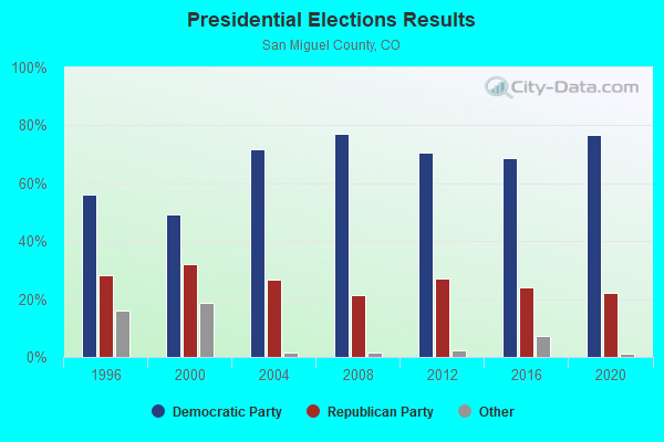
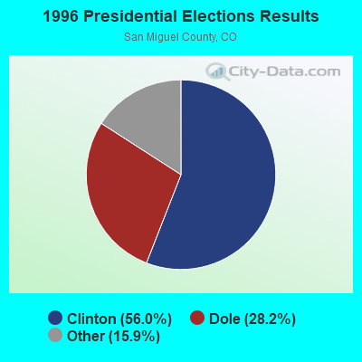
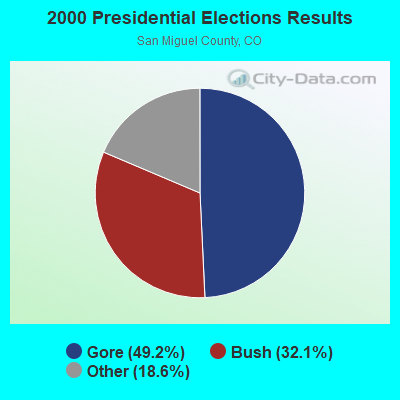
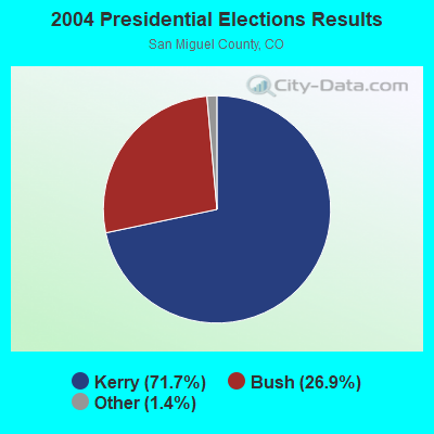
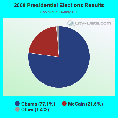
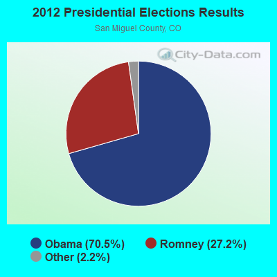
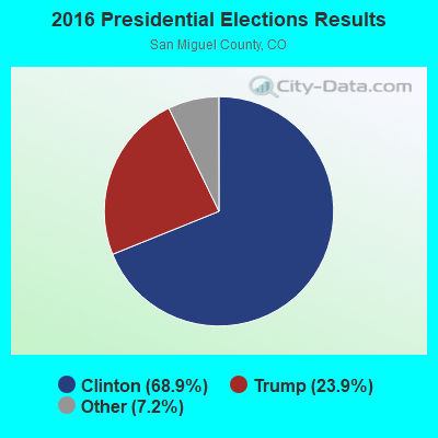

Graphs represent county-level data. Detailed 2008 Election Results
Religion statistics for Gladel, CO (based on San Miguel County data)
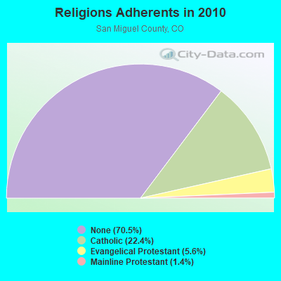
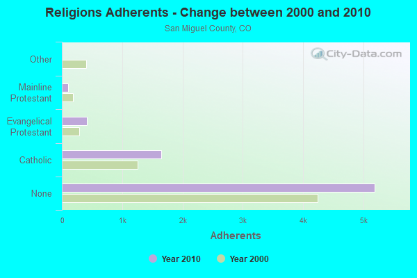
| Religion | Adherents | Congregations |
|---|---|---|
| Catholic | 1,651 | 1 |
| Evangelical Protestant | 413 | 5 |
| Mainline Protestant | 105 | 1 |
| Other | 2 | 1 |
| None | 5,188 | - |
Food Environment Statistics:
| This county: | 5.33 / 10,000 pop. |
| Colorado: | 1.50 / 10,000 pop. |
| San Miguel County: | 2.66 / 10,000 pop. |
| Colorado: | 0.45 / 10,000 pop. |
| San Miguel County: | 2.66 / 10,000 pop. |
| Colorado: | 3.13 / 10,000 pop. |
| San Miguel County: | 37.31 / 10,000 pop. |
| State: | 8.99 / 10,000 pop. |
| San Miguel County: | 4.2% |
| Colorado: | 5.3% |
| San Miguel County: | 14.9% |
| State: | 18.4% |
Strongest AM radio stations in Gladel:
- KNZZ (1100 AM; 50 kW; GRAND JUNCTION, CO; Owner: M B C GRAND BROADCASTING, INC.)
- KTNN (660 AM; 50 kW; WINDOW ROCK, AZ; Owner: THE NAVAJO NATION)
- KJOL (620 AM; 10 kW; GRAND JUNCTION, CO; Owner: UNITED MINISTRIES)
- KUBC (580 AM; 5 kW; MONTROSE, CO; Owner: WOODLAND COMMUNICATIONS CORPORATION)
- KHAC (880 AM; 43 kW; TSE BONITO, NM; Owner: WESTERN INDIAN MINISTRIES, INC.)
- KKOB (770 AM; 50 kW; ALBUQUERQUE, NM; Owner: CITADEL BROADCASTING COMPANY)
- KLTT (670 AM; 50 kW; COMMERCE CITY, CO; Owner: KLZ RADIO, INC.)
- KALL (700 AM; 50 kW; NORTH SALT LAKE CITY, UT; Owner: CITICASTERS LICENSES, L.P.)
- KKZN (760 AM; 50 kW; THORNTON, CO; Owner: JACOR BROADCASTING OF COLORADO, INC.)
- KIUP (930 AM; 5 kW; DURANGO, CO; Owner: FOUR CORNERS BROADCASTING, LLC)
- KOA (850 AM; 50 kW; DENVER, CO; Owner: JACOR BROADCASTING OF COLORADO, INC.)
- KIQN (1010 AM; 50 kW; TOOELE, UT)
- KENN (1390 AM; 10 kW; FARMINGTON, NM; Owner: WINTON ROAD BROADCASTING CO, LLC)
Strongest FM radio stations in Gladel:
- K248AJ (97.5 FM; MONTICELLO, UT; Owner: PROCLAIMING CHRIST'S LOVE MINISTRIES)
- K213BX (90.5 FM; NUCLA, CO; Owner: EDUCATIONAL MEDIA FOUNDATION)
- KRTZ (98.7 FM; CORTEZ, CO; Owner: WINTON ROAD BROADCASTING CO., LLC)
- KVMT (89.1 FM; MONTROSE, CO; Owner: NORTH FORK VALLEY PUBLIC RADIO, INC)
- KRYD (104.9 FM; NORWOOD, CO; Owner: ROCKY III INVESTMENTS, INC.)
- KCYN (97.1 FM; MOAB, UT; Owner: MOAB COMMUNICATIONS, LLC)
- K232DA (94.3 FM; HESPERUS, CO; Owner: NATIVE AMERICAN CHRISTIAN VOICE, INC.)
- K237CR (95.3 FM; HESPERUS, CO; Owner: NATIVE AMERICAN CHRISTIAN VOICE, INC.)
- K291AF (106.1 FM; CASTLE VALLEY, UT; Owner: MOAB PUBLIC RADIO, INC.)
- KOTO (91.7 FM; TELLURIDE, CO; Owner: SAN MIGUEL EDUCATIONAL FUND, INC.)
- K277AF (103.3 FM; CASTLE VALLEY, ETC., UT; Owner: EDUCATIONAL MEDIA FOUNDATION)
- K216DB (91.1 FM; PLEASANT VIEW, CO; Owner: SAN JUAN BASIN AREA VOCATIONAL TECH.)

- 41.7%Bottled, tank, or LP gas
- 31.2%Wood
- 22.9%Utility gas
- 4.2%Electricity

- 66.7%Bottled, tank, or LP gas
- 33.3%Utility gas
Gladel compared to Colorado state average:
- Median household income below state average.
- Median house value significantly below state average.
- Unemployed percentage significantly below state average.
- Black race population percentage significantly below state average.
- Hispanic race population percentage below state average.
- Median age significantly above state average.
- Foreign-born population percentage significantly below state average.
- Renting percentage significantly below state average.
- Length of stay since moving in significantly above state average.
- Number of rooms per house significantly below state average.
- House age significantly below state average.
- Number of college students below state average.
- Percentage of population with a bachelor's degree or higher significantly below state average.
Gladel on our top lists:
- #20 on the list of "Top 101 larger cities with the lowest real estate taxes percentage (population 50,000+)"
- #72 (81325) on the list of "Top 101 zip codes with the largest percentage of Scottish first ancestries"
- #5 on the list of "Top 101 counties with the lowest number of deaths per 1000 residents 2007-2013"
- #38 on the list of "Top 101 counties with the largest number of children under 18 without health insurance coverage in 2000"
- #46 on the list of "Top 101 counties with the highest percentage of residents relocating to foreign countries in 2011"
- #47 on the list of "Top 101 counties with the highest percentage of residents relocating from other counties between 2010 and 2011"
- #64 on the list of "Top 101 counties with the highest percentage of residents relocating to other counties in 2011"