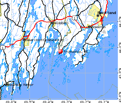
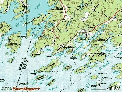
Friendship, Maine

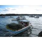
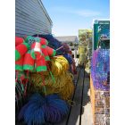
Friendship: Skiffs and dories!
Friendship: Picture at dock in the Fall
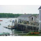
Friendship: Friendship Warf
Friendship: Friendship, Maine

Friendship: A Criminal Trespass
Friendship: Friendship, Maine
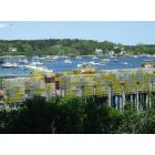
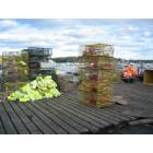
Friendship: Friendship Harbor Traps 2008
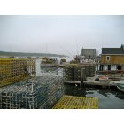
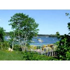
Friendship: Friendship Harbor
Friendship: Friendship Pier in the fall
- add
your
Submit your own pictures of this town and show them to the world
- OSM Map
- General Map
- Google Map
- MSN Map
Population change since 2000: -4.3%
 |
| Males: 581 | |
| Females: 571 |
| Median resident age: | 50.1 years |
| Maine median age: | 43.0 years |
Zip codes: 04547.
| Friendship: | $75,123 |
| ME: | $69,543 |
Estimated per capita income in 2022: $41,711 (it was $20,409 in 2000)
Friendship town income, earnings, and wages data
Estimated median house or condo value in 2022: $274,476 (it was $97,700 in 2000)
| Friendship: | $274,476 |
| ME: | $290,600 |
Detailed information about poverty and poor residents in Friendship, ME
Compare current foreclosures near Friendship, ME:
| Photo | Address | Area | Beds / Baths | Price | Details |
|---|---|---|---|---|---|

|
#1
Reef Rd
Waldoboro, ME 04572
|
1,344 sq. feet
|
2 baths 3 beds |
show details | |

|
#2
River Rd
Tenants Harbor, ME 04860
|
- sq. feet
|
- baths - beds |
show details | |

|
#3
Hookers Way
Boothbay, ME 04537
|
- sq. feet
|
- baths - beds |
show details | |

|
#4
Philbrick Ave
Rockland, ME 04841
|
- sq. feet
|
- baths - beds |
show details | |

|
#5
Cape Hill Rd
Jefferson, ME 04348
|
- sq. feet
|
- baths - beds |
show details | |

|
#6
Waldoboro Rd
Bremen, ME 04551
|
- sq. feet
|
- baths - beds |
show details | |

|
#7
Genthner Rd
Waldoboro, ME 04572
|
- sq. feet
|
- baths - beds |
show details | |

|
#8
Beechwood St
Thomaston, ME 04861
|
- sq. feet
|
- baths - beds |
show details | |

|
#9
S Union Rd
Union, ME 04862
|
- sq. feet
|
- baths - beds |
show details | |

|
#10
Washington Rd
Jefferson, ME 04348
|
- sq. feet
|
- baths - beds |
show details |
| Photo | Address | Area | Beds / Baths | Price | Details |
|---|---|---|---|---|---|

|
Check over 1 million property listings on Foreclosure.com!
|
browse all offers | |||
| Photo | Address | Area | Beds / Baths | Price | Details |
|---|

- 1,14299.1%White alone
- 40.3%Two or more races
- 40.3%Hispanic
- 20.2%Asian alone
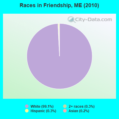
Races in Friendship detailed stats: ancestries, foreign born residents, place of birth
 Recent articles from our blog. Our writers, many of them Ph.D. graduates or candidates, create easy-to-read articles on a wide variety of topics.

 | Well, here goes. The start to our trek North to Maine, our new home-state. (395 replies) |
| Move to Maine after retirement-suggested towns? (16 replies) |
| Why is Maine a poor state? (241 replies) |
| Tax Friendly, Modern, Family-Sized, Reasonably Priced Homes (14 replies) |
| Gasoline prices in Maine rise 5.1 cents in last week. (105 replies) |
| Hello Mainers of City-Data! (23 replies) |
Latest news from Friendship, ME collected exclusively by city-data.com from local newspapers, TV, and radio stations
Ancestries: English (21.3%), German (14.3%), United States (9.4%), Irish (8.9%), French (4.2%), Scottish (3.8%).
Current Local Time: EST time zone
Incorporated on 02/25/1807
Elevation: 146 feet
Land area: 14.0 square miles.
Population density: 82 people per square mile (very low).
14 residents are foreign born
| This town: | 1.2% |
| Maine: | 2.9% |
| Friendship town: | 1.0% ($977) |
| Maine: | 1.5% ($1,417) |
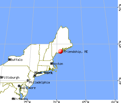
Nearest city with pop. 50,000+: Portland, ME  (51.4 miles , pop. 64,249).
Nearest city with pop. 200,000+: Boston, MA (145.0 miles , pop. 589,141).
Nearest city with pop. 1,000,000+: Bronx, NY (317.2 miles , pop. 1,332,650).
Nearest cities:
), ), ), ), Latitude: 43.98 N, Longitude: 69.34 W
Area code commonly used in this area: 207

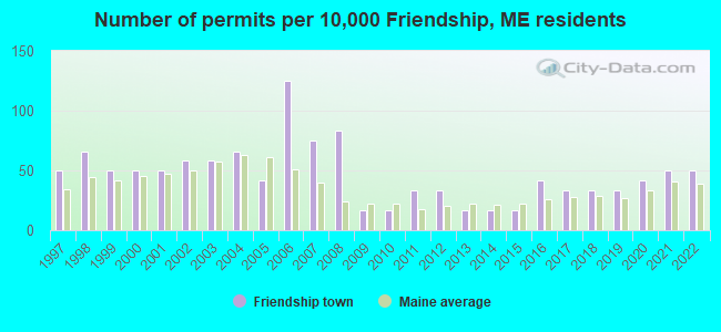
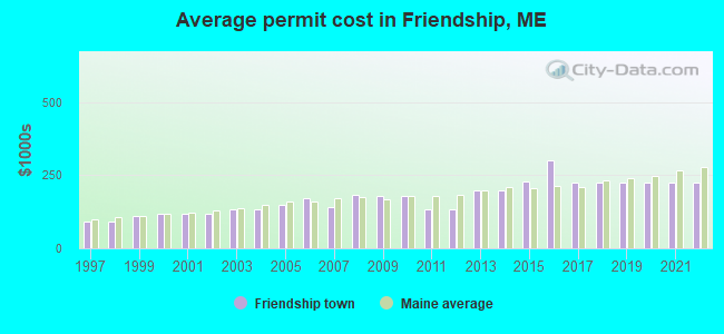
Single-family new house construction building permits:
- 2022: 6 buildings, average cost: $223,800
- 2021: 6 buildings, average cost: $223,800
- 2020: 5 buildings, average cost: $223,800
- 2019: 4 buildings, average cost: $223,800
- 2018: 4 buildings, average cost: $223,800
- 2017: 4 buildings, average cost: $223,800
- 2016: 5 buildings, average cost: $300,000
- 2015: 2 buildings, average cost: $226,800
- 2014: 2 buildings, average cost: $200,000
- 2013: 2 buildings, average cost: $200,000
- 2012: 4 buildings, average cost: $133,300
- 2011: 4 buildings, average cost: $133,300
- 2010: 2 buildings, average cost: $178,900
- 2009: 2 buildings, average cost: $178,900
- 2008: 10 buildings, average cost: $182,400
- 2007: 9 buildings, average cost: $140,000
- 2006: 15 buildings, average cost: $171,000
- 2005: 5 buildings, average cost: $150,200
- 2004: 8 buildings, average cost: $132,800
- 2003: 7 buildings, average cost: $132,800
- 2002: 7 buildings, average cost: $118,000
- 2001: 6 buildings, average cost: $118,000
- 2000: 6 buildings, average cost: $118,000
- 1999: 6 buildings, average cost: $109,200
- 1998: 8 buildings, average cost: $91,700
- 1997: 6 buildings, average cost: $91,700
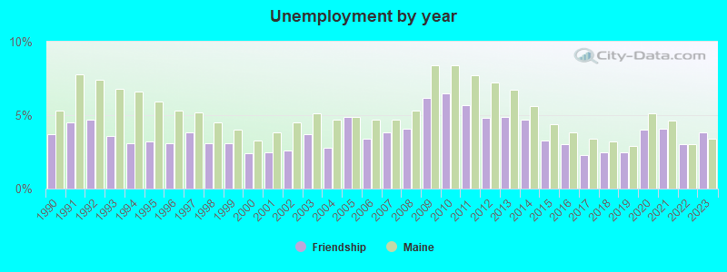
| Here: | 3.8% |
| Maine: | 3.4% |
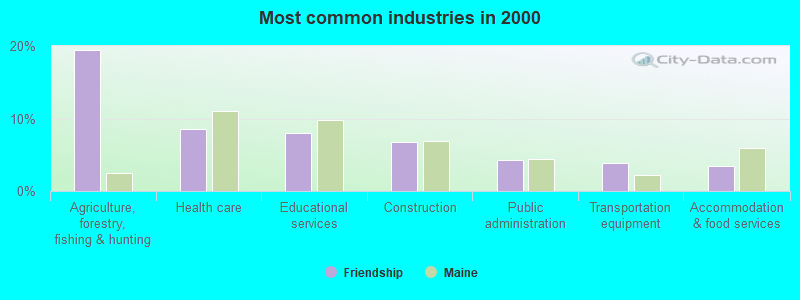
- Agriculture, forestry, fishing & hunting (19.4%)
- Health care (8.6%)
- Educational services (8.1%)
- Construction (6.8%)
- Public administration (4.2%)
- Transportation equipment (3.8%)
- Accommodation & food services (3.5%)
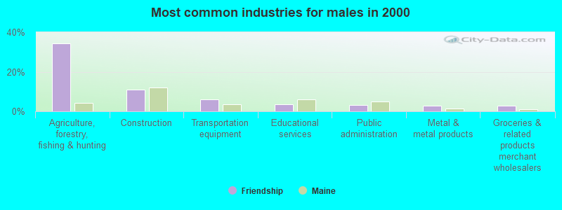
- Agriculture, forestry, fishing & hunting (34.2%)
- Construction (11.0%)
- Transportation equipment (6.1%)
- Educational services (3.5%)
- Public administration (3.2%)
- Metal & metal products (2.9%)
- Groceries & related products merchant wholesalers (2.9%)
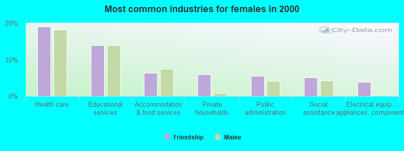
- Health care (19.1%)
- Educational services (14.0%)
- Accommodation & food services (6.4%)
- Private households (5.9%)
- Public administration (5.5%)
- Social assistance (5.1%)
- Electrical equipment, appliances, components (3.8%)
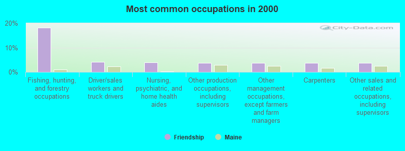
- Fishing, hunting, and forestry occupations (18.1%)
- Driver/sales workers and truck drivers (4.0%)
- Nursing, psychiatric, and home health aides (3.8%)
- Other production occupations, including supervisors (3.7%)
- Other management occupations, except farmers and farm managers (3.7%)
- Carpenters (3.7%)
- Other sales and related occupations, including supervisors (3.7%)
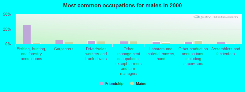
- Fishing, hunting, and forestry occupations (31.9%)
- Carpenters (6.5%)
- Driver/sales workers and truck drivers (5.8%)
- Other management occupations, except farmers and farm managers (4.8%)
- Laborers and material movers, hand (3.9%)
- Other production occupations, including supervisors (3.2%)
- Assemblers and fabricators (2.9%)

- Nursing, psychiatric, and home health aides (8.9%)
- Other office and administrative support workers, including supervisors (6.8%)
- Preschool, kindergarten, elementary, and middle school teachers (5.9%)
- Other sales and related occupations, including supervisors (4.7%)
- Information and record clerks, except customer service representatives (4.7%)
- Other production occupations, including supervisors (4.2%)
- Registered nurses (3.8%)
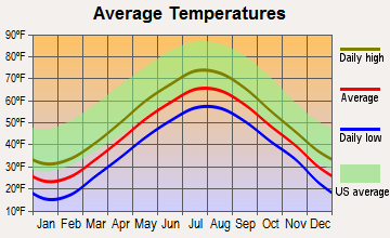
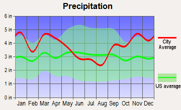
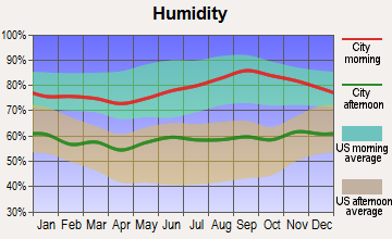
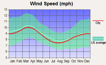
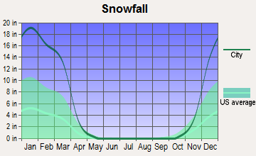
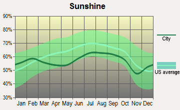
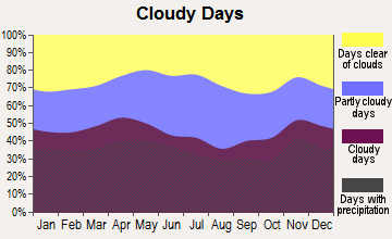
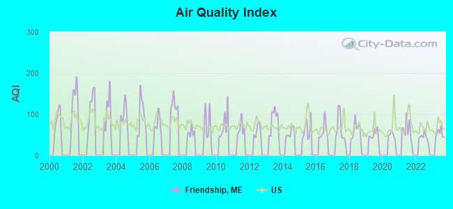
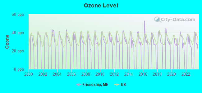
Average climate in Friendship, Maine
Based on data reported by over 4,000 weather stations
Earthquake activity:
Friendship-area historical earthquake activity is significantly above Maine state average. It is 77% smaller than the overall U.S. average.On 10/16/2012 at 23:12:25, a magnitude 4.7 (4.7 ML, Depth: 10.0 mi, Class: Light, Intensity: IV - V) earthquake occurred 71.0 miles away from Friendship center
On 4/20/2002 at 10:50:47, a magnitude 5.3 (5.3 ML, Depth: 3.0 mi, Class: Moderate, Intensity: VI - VII) earthquake occurred 219.0 miles away from the city center
On 1/19/1982 at 00:14:42, a magnitude 4.7 (4.5 MB, 4.7 MD, 4.5 LG) earthquake occurred 117.8 miles away from the city center
On 4/20/2002 at 10:50:47, a magnitude 5.2 (5.2 MB, 4.2 MS, 5.2 MW, 5.0 MW) earthquake occurred 219.8 miles away from Friendship center
On 10/7/1983 at 10:18:46, a magnitude 5.3 (5.1 MB, 5.3 LG, 5.1 ML) earthquake occurred 249.0 miles away from Friendship center
On 2/26/1999 at 03:38:43, a magnitude 3.8 (3.8 LG, Depth: 2.0 mi, Class: Light, Intensity: II - III) earthquake occurred 35.5 miles away from Friendship center
Magnitude types: regional Lg-wave magnitude (LG), body-wave magnitude (MB), duration magnitude (MD), local magnitude (ML), surface-wave magnitude (MS), moment magnitude (MW)
Natural disasters:
The number of natural disasters in Knox County (23) is greater than the US average (15).Major Disasters (Presidential) Declared: 18
Emergencies Declared: 4
Causes of natural disasters: Floods: 16, Storms: 12, Winter Storms: 4, Snows: 3, Hurricanes: 2, Blizzard: 1, Heavy Rain: 1, Ice Storm: 1, Landslide: 1, Mudslide: 1, Snowfall: 1, Wind: 1, Other: 1 (Note: some incidents may be assigned to more than one category).
Hospitals and medical centers near Friendship:
- FIELDCREST MANOR (Nursing Home, about 10 miles away; WALDOBORO, ME)
- COVE'S EDGE (Nursing Home, about 10 miles away; DAMARISCOTTA, ME)
- KNO-WAL-LIN HOMECARE AND HOSPICE (Home Health Center, about 14 miles away; ROCKLAND, ME)
- KNOX CENTER FOR LONG TERM CARE (Nursing Home, about 15 miles away; ROCKLAND, ME)
- KNOX CENTER FOR LTC (Nursing Home, about 15 miles away; ROCKLAND, ME)
- SHORE VILLAGE REHAB AND NURSING (Nursing Home, about 16 miles away; ROCKLAND, ME)
Colleges/universities with over 2000 students nearest to Friendship:
- University of Maine at Augusta (about 34 miles; Augusta, ME; Full-time enrollment: 3,204)
- Southern Maine Community College (about 51 miles; South Portland, ME; FT enrollment: 4,666)
- University of Southern Maine (about 52 miles; Portland, ME; FT enrollment: 6,647)
- Saint Joseph's College of Maine (about 59 miles; Standish, ME; FT enrollment: 2,010)
- University of Maine at Farmington (about 62 miles; Farmington, ME; FT enrollment: 2,036)
- University of New England (about 64 miles; Biddeford, ME; FT enrollment: 4,539)
- Husson University (about 65 miles; Bangor, ME; FT enrollment: 2,421)
Public elementary/middle school in Friendship:
- FRIENDSHIP VILLAGE SCHOOL (Students: 94, Location: 23 SCHOOL ST 100, Grades: KG-6)
Points of interest:
Notable locations in Friendship: Friendship Volunteer Fire Department (A), Friendship Museum (B). Display/hide their locations on the map
Cemeteries: Village Cemetery (1), Harbor Cemetery (2), Wayside Cemetery (3). Display/hide their locations on the map
Reservoirs: Crystal Pond (A), Forest Pond (B). Display/hide their locations on the map
Streams, rivers, and creeks: Back River (A), Goose River (B), Waterman Brook (C). Display/hide their locations on the map
Drinking water stations with addresses in Friendship that have no violations reported:
- FRIENDSHIP WATER DEPARTMENT (Population served: 85, Primary Water Source Type: Groundwater)
| This town: | 2.3 people |
| Maine: | 2.3 people |
| This town: | 69.3% |
| Whole state: | 62.9% |
| This town: | 7.9% |
| Whole state: | 9.4% |
Likely homosexual households (counted as self-reported same-sex unmarried-partner households)
- Lesbian couples: 0.4% of all households
- Gay men: 0.2% of all households
| This town: | 11.0% |
| Whole state: | 10.9% |
| This town: | 5.9% |
| Whole state: | 4.1% |
For population 15 years and over in Friendship:
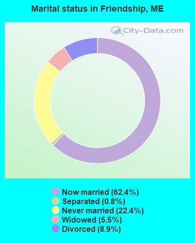
- Never married: 22.4%
- Now married: 62.4%
- Separated: 0.8%
- Widowed: 5.5%
- Divorced: 8.9%
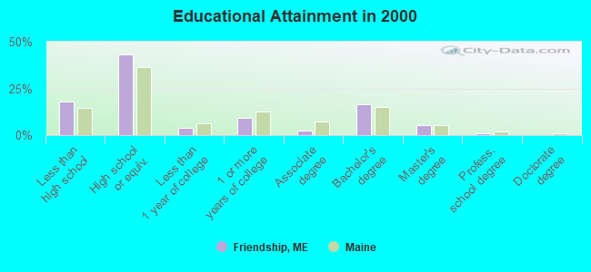
For population 25 years and over in Friendship:
- High school or higher: 82.0%
- Bachelor's degree or higher: 22.8%
- Graduate or professional degree: 6.3%
- Unemployed: 2.7%
- Mean travel time to work (commute): 22.5 minutes
| Here: | 11.0 |
| Maine average: | 11.2 |
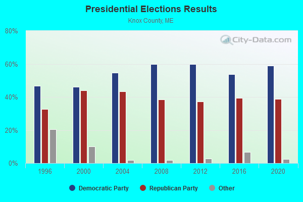
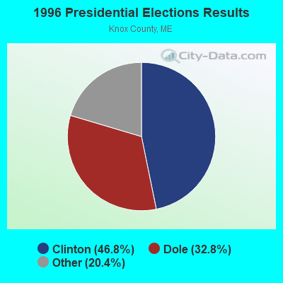
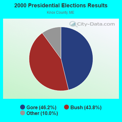
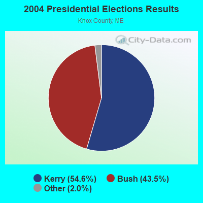

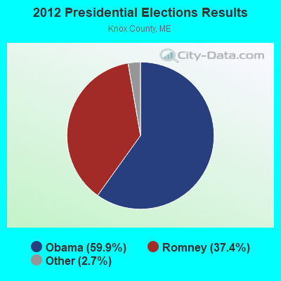
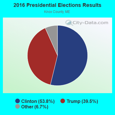
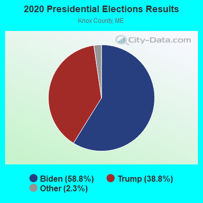
Graphs represent county-level data. Detailed 2008 Election Results
Religion statistics for Friendship, ME (based on Knox County data)
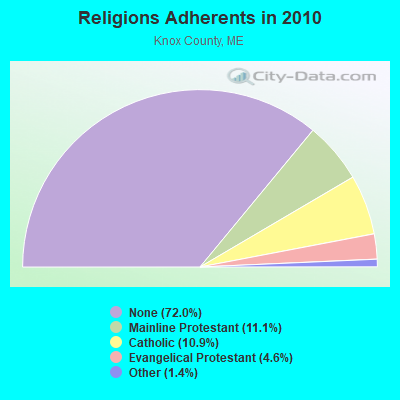
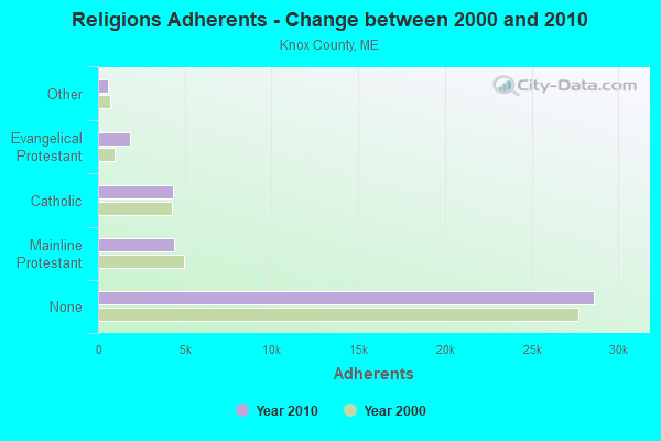
| Religion | Adherents | Congregations |
|---|---|---|
| Mainline Protestant | 4,400 | 29 |
| Catholic | 4,340 | 4 |
| Evangelical Protestant | 1,813 | 23 |
| Other | 569 | 6 |
| None | 28,614 | - |
Food Environment Statistics:
| Knox County: | 4.17 / 10,000 pop. |
| State: | 2.80 / 10,000 pop. |
| Knox County: | 2.21 / 10,000 pop. |
| Maine: | 2.20 / 10,000 pop. |
| Here: | 7.37 / 10,000 pop. |
| State: | 5.75 / 10,000 pop. |
| This county: | 19.40 / 10,000 pop. |
| State: | 11.02 / 10,000 pop. |
| Here: | 7.8% |
| Maine: | 8.2% |
| Here: | 21.6% |
| Maine: | 25.0% |
Strongest AM radio stations in Friendship:
- WFAU (1280 AM; 5 kW; GARDINER, ME; Owner: CAPSTAR TX LIMITED PARTNERSHIP)
- WRKD (1450 AM; 1 kW; ROCKLAND, ME; Owner: CLEAR CHANNEL BROADCASTING LICENSES, INC.)
- WRKO (680 AM; 50 kW; BOSTON, MA; Owner: ENTERCOM BOSTON LICENSE, LLC)
- WGAN (560 AM; 5 kW; PORTLAND, ME; Owner: SAGA COMMUNICATIONS OF NEW ENGLAND, LLC)
- WMTW (870 AM; 10 kW; GORHAM, ME; Owner: RADIO PARTNERS OF MAINE, L.P.)
- WSKW (1160 AM; 10 kW; SKOWHEGAN, ME; Owner: MOUNTAIN WIRELESS, INCORPORATED)
- WTME (780 AM; 10 kW; RUMFORD, ME; Owner: MOUNTAIN VALLEY BROADCASTING, INC.)
- WEEI (850 AM; 50 kW; BOSTON, MA; Owner: ENTERCOM BOSTON LICENSE, LLC)
- WBZ (1030 AM; 50 kW; BOSTON, MA; Owner: INFINITY BROADCASTING OPERATIONS, INC.)
- WJTO (730 AM; 1 kW; BATH, ME; Owner: BLUE JEY BROADCASTING COMPANY)
- WCRN (830 AM; 50 kW; WORCESTER, MA; Owner: CARTER BROADCASTING CORPORATION)
- WZON (620 AM; 5 kW; BANGOR, ME; Owner: THE ZONE CORPORATION)
- WKOX (1200 AM; 50 kW; FRAMINGHAM, MA; Owner: CAPSTAR TX LIMITED PARTNERSHIP)
Strongest FM radio stations in Friendship:
- WMEP (90.5 FM; CAMDEN, ME; Owner: MAINE PUBLIC BROADCASTING CORP.)
- WQSS (102.5 FM; CAMDEN, ME; Owner: CLEAR CHANNEL BROADCASTING LICENSES, INC.)
- WMCM (103.3 FM; ROCKLAND, ME; Owner: CLEAR CHANNEL BROADCASTING LICENSES, INC.)
- WBQX (106.9 FM; THOMASTON, ME; Owner: MARINER BROADCASTING LIMITED PARTNER)
- WCME (96.7 FM; BOOTHBAY HARBOR, ME; Owner: CAPSTAR TX LIMITED PARTNERSHIP)
- WFZX (101.7 FM; SEARSPORT, ME; Owner: CLEAR CHANNEL BROADCASTING LICENSES, INC.)
- WBFB (104.7 FM; BELFAST, ME; Owner: CLEAR CHANNEL BROADCASTING LICENSES, INC.)
- WBCI (105.9 FM; BATH, ME; Owner: BLOUNT COMMUNICATIONS, INC.)
- WMME-FM (92.3 FM; AUGUSTA, ME; Owner: CITADEL BROADCASTING COMPANY)
TV broadcast stations around Friendship:
- W64BY (Channel 64; ROCKLAND, ME; Owner: CRAIG MINISTRIES, INC.)
- WPFO (Channel 23; WATERVILLE, ME; Owner: CMCG PORTLAND LICENSE LLC)
Friendship fatal accident list:
Aug 10, 2006 01:49 PM, Finn Town Road, Lat: 44.043730, Lon: -69.308710, Vehicles: 1, Persons: 1, Fatalities: 1
Sep 18, 1994 01:15 PM, 97, Vehicles: 1, Persons: 1, Fatalities: 1
Jun 15, 1992 05:20 PM, 97, Vehicles: 1, Persons: 1, Fatalities: 1
Jun 22, 1984 04:20 AM, 5002, Vehicles: 1, Persons: 3, Fatalities: 1, Drunk persons involved: 1
- National Bridge Inventory (NBI) Statistics
- 1Number of bridges
- 3ft / 0.8mTotal length
- 1,240Total average daily traffic
- 62Total average daily truck traffic
- 1,860Total future (year 2036) average daily traffic
FCC Registered Antenna Towers:
6- Erik Brooks, Main Street (Lat: 43.984806 Lon: -69.332250), Type: 32.3, Overall height: 30.4 m, Registrant: Holland & Knight LLP, Pconnolly@hklaw.Com, , Washi-ngton, Phone: (202) 862-5989
- Erik Brooks, Main Street (Lat: 43.984806 Lon: -69.332250), Type: 32.3, Structure height: 23013 m, Overall height: 30.4 m, Registrant: Holland & Knight LLP, Pconnolly@hklaw.Com, , Washi-ngton, Phone: (202) 862-5989
- Cayla Gamble, Main Street (Lat: 43.984806 Lon: -69.332250), Type: 32.3, Structure height: 23013 m, Overall height: 30.4 m, Registrant: Wilkinson Barker Knauer, LLP, Gwerner@wbklaw.Com, , Washi-ngton, Phone: (202) 383-3420
- Cayla Gamble, 25 Main St (Lat: 43.984806 Lon: -69.332250), Type: 32.3, Structure height: 23013 m, Overall height: 30.4 m, Registrant: Wilkinson Barker Knauer, LLP, Gwerner@wbklaw.Com, , Washi-ngton, Phone: (202) 383-3420
- Cayla Gamble, 25 Main St (Lat: 43.984806 Lon: -69.332250), Type: 32.3, Structure height: 23013 m, Overall height: 30.4 m, Registrant: Wilkinson Barker Knauer, LLP, Gwerner@wbklaw.Com, , Washi-ngton, Phone: (202) 383-3420
- Cayla Gamble, 25 Main St (Lat: 43.984806 Lon: -69.332250), Type: 32.3, Structure height: 23013 m, Overall height: 30.4 m, Registrant: Wilkinson Barker Knauer, LLP, Gwerner@wbklaw.Com, , Washi-ngton, Phone: (202) 383-3420
FCC Registered Maritime Coast & Aviation Ground Towers:
1- Halls Wharf Friendship Harbor (Lat: 43.991750 Lon: -69.337000), Type: Building, Overall height: 4 m, Call Sign: WHH354, Licensee ID: L00003703,
Assigned Frequencies: 156.450 MHz, 156.475 MHz, 156.800 MHz, Grant Date: 10/28/1999, Expiration Date: 12/22/2004, Cancellation Date: 02/26/2005, Registrant: William L Hall, Halls Wharf Box 130, Friendship, ME 04547
FCC Registered Amateur Radio Licenses:
18 (See the full list of FCC Registered Amateur Radio Licenses in Friendship)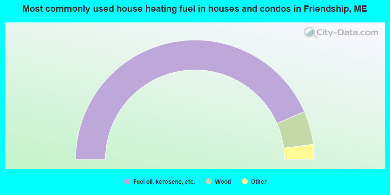
- 86.9%Fuel oil, kerosene, etc.
- 9.1%Wood
- 1.9%Bottled, tank, or LP gas
- 1.6%Electricity
- 0.5%Utility gas
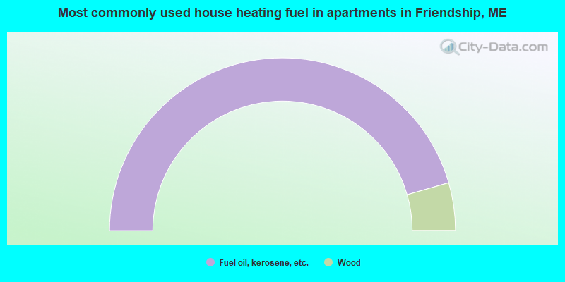
- 91.1%Fuel oil, kerosene, etc.
- 8.9%Wood
Friendship compared to Maine state average:
- Unemployed percentage significantly below state average.
- Black race population percentage significantly below state average.
- Hispanic race population percentage significantly below state average.
- Median age above state average.
- Foreign-born population percentage significantly below state average.
- Renting percentage significantly below state average.
- Length of stay since moving in significantly above state average.
- Number of rooms per house significantly below state average.
- House age significantly below state average.