Freeman, Wisconsin
Submit your own pictures of this town and show them to the world
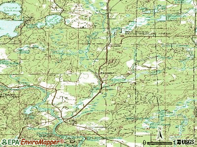
- OSM Map
- General Map
- Google Map
- MSN Map
Population change since 2000: -4.6%
 |
| Males: 361 | |
| Females: 325 |
| Median resident age: | 52.0 years |
| Wisconsin median age: | 42.6 years |
Zip codes: 54628.
| Freeman: | $53,249 |
| WI: | $70,996 |
Estimated per capita income in 2022: $31,747 (it was $16,609 in 2000)
Freeman town income, earnings, and wages data
Estimated median house or condo value in 2022: $183,302 (it was $80,700 in 2000)
| Freeman: | $183,302 |
| WI: | $252,800 |
Mean prices in 2022: all housing units: $215,491; detached houses: $223,123; townhouses or other attached units: $368,547; in 2-unit structures: $166,269; in 5-or-more-unit structures: $204,114; mobile homes: $108,006
Detailed information about poverty and poor residents in Freeman, WI


- 67398.1%White alone
- 30.4%Black alone
- 30.4%American Indian alone
- 30.4%Two or more races
- 20.3%Native Hawaiian and Other
Pacific Islander alone - 10.1%Asian alone
- 10.1%Hispanic

Races in Freeman detailed stats: ancestries, foreign born residents, place of birth
 Recent articles from our blog. Our writers, many of them Ph.D. graduates or candidates, create easy-to-read articles on a wide variety of topics.

 | Dear MKE Drivers, the left lane is for going fast (142 replies) |
| Maybe I've lived a sheltered life? (127 replies) |
Latest news from Freeman, WI collected exclusively by city-data.com from local newspapers, TV, and radio stations
Ancestries: Norwegian (36.3%), German (25.3%), English (9.5%), Irish (9.0%), United States (3.2%), Swedish (3.1%).
Current Local Time: CST time zone
Elevation: 1500 feet
Land area: 68.2 square miles.
Population density: 10 people per square mile (very low).
11 residents are foreign born
| This town: | 1.5% |
| Wisconsin: | 3.6% |
| Freeman town: | 1.2% ($991) |
| Wisconsin: | 2.0% ($2,245) |
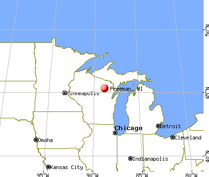
Nearest city with pop. 50,000+: La Crosse, WI  (32.4 miles , pop. 51,818).
Nearest city with pop. 200,000+: Madison, WI (86.6 miles , pop. 208,054).
Nearest city with pop. 1,000,000+: Chicago, IL (202.0 miles , pop. 2,896,016).
Nearest cities:
), Latitude: 43.36 N, Longitude: 91.07 W


Single-family new house construction building permits:
- 2022: 5 buildings, average cost: $183,000
- 2021: 18 buildings, average cost: $280,600
- 2020: 1 building, cost: $255,000
- 2019: 2 buildings, average cost: $97,500
- 2018: 2 buildings, average cost: $342,500
- 2017: 10 buildings, average cost: $199,800
- 2016: 6 buildings, average cost: $135,000
- 2015: 5 buildings, average cost: $126,000
- 2014: 7 buildings, average cost: $119,400
- 2013: 6 buildings, average cost: $155,800
- 2012: 3 buildings, average cost: $146,700
- 2011: 5 buildings, average cost: $156,000
- 2010: 8 buildings, average cost: $121,800
- 2009: 7 buildings, average cost: $162,400
- 2008: 7 buildings, average cost: $140,300
- 2007: 12 buildings, average cost: $157,400
- 2006: 3 buildings, average cost: $50,000
- 2005: 6 buildings, average cost: $150,000
- 2004: 12 buildings, average cost: $66,700
- 2003: 8 buildings, average cost: $81,900
- 2002: 8 buildings, average cost: $40,000
- 2000: 6 buildings, average cost: $49,200
- 1999: 3 buildings, average cost: $41,300
- 1998: 5 buildings, average cost: $50,000
- 1997: 4 buildings, average cost: $50,000


| Here: | 4.3% |
| Wisconsin: | 2.7% |

- Agriculture, forestry, fishing & hunting (20.8%)
- Health care (5.8%)
- Educational services (5.0%)
- Finance & insurance (4.7%)
- Construction (3.8%)
- Miscellaneous manufacturing (3.8%)
- Building material & garden equipment & supplies dealers (3.5%)

- Agriculture, forestry, fishing & hunting (30.3%)
- Construction (6.6%)
- Building material & garden equipment & supplies dealers (4.0%)
- Machinery (4.0%)
- Health care (3.5%)
- Metal & metal products (3.5%)
- Professional, scientific, technical services (3.0%)

- Educational services (11.8%)
- Health care (9.0%)
- Finance & insurance (8.3%)
- Agriculture, forestry, fishing & hunting (7.6%)
- Miscellaneous manufacturing (6.9%)
- Food & beverage stores (5.6%)
- Electronic shopping & mail-order houses (4.9%)

- Farmers and farm managers (16.1%)
- Other production occupations, including supervisors (6.4%)
- Other sales and related occupations, including supervisors (5.0%)
- Secretaries and administrative assistants (4.4%)
- Assemblers and fabricators (4.1%)
- Laborers and material movers, hand (3.5%)
- Material recording, scheduling, dispatching, and distributing workers (3.5%)

- Farmers and farm managers (23.2%)
- Other sales and related occupations, including supervisors (5.6%)
- Driver/sales workers and truck drivers (5.1%)
- Electrical equipment mechanics and other installation, maintenance, and repair workers, including supervisors (4.5%)
- Assemblers and fabricators (4.5%)
- Other production occupations, including supervisors (4.5%)
- Material recording, scheduling, dispatching, and distributing workers (4.0%)

- Secretaries and administrative assistants (10.4%)
- Other production occupations, including supervisors (9.0%)
- Laborers and material movers, hand (6.9%)
- Farmers and farm managers (6.2%)
- Financial clerks, except bookkeeping, accounting and auditing clerks (4.9%)
- Other office and administrative support workers, including supervisors (4.9%)
- Cashiers (4.2%)
Average climate in Freeman, Wisconsin
Based on data reported by over 4,000 weather stations


Tornado activity:
Freeman-area historical tornado activity is slightly above Wisconsin state average. It is 38% greater than the overall U.S. average.
On 4/30/1954, a category F4 (max. wind speeds 207-260 mph) tornado 13.6 miles away from the Freeman town center .
On 4/11/1965, a category F4 tornado 32.8 miles away from the town center killed one person and injured 3 people and caused between $500,000 and $5,000,000 in damages.
Earthquake activity:
Freeman-area historical earthquake activity is significantly above Wisconsin state average. It is 62% greater than the overall U.S. average.On 4/18/2008 at 09:36:59, a magnitude 5.4 (5.1 MB, 4.8 MS, 5.4 MW, 5.2 MW, Class: Moderate, Intensity: VI - VII) earthquake occurred 378.0 miles away from the city center
On 6/28/2004 at 06:10:52, a magnitude 4.2 (4.2 MW, Depth: 6.2 mi, Class: Light, Intensity: IV - V) earthquake occurred 171.8 miles away from the city center
On 6/10/1987 at 23:48:54, a magnitude 5.1 (4.9 MB, 4.4 MS, 4.6 MS, 5.1 LG) earthquake occurred 355.1 miles away from the city center
On 4/18/2008 at 09:36:59, a magnitude 5.2 (5.2 MW, Depth: 8.9 mi) earthquake occurred 378.0 miles away from the city center
On 7/9/1975 at 14:54:15, a magnitude 4.6 (4.6 MB) earthquake occurred 292.6 miles away from the city center
On 2/10/2010 at 09:59:35, a magnitude 3.8 (3.8 MW, Depth: 6.2 mi, Class: Light, Intensity: II - III) earthquake occurred 162.3 miles away from the city center
Magnitude types: regional Lg-wave magnitude (LG), body-wave magnitude (MB), surface-wave magnitude (MS), moment magnitude (MW)
Natural disasters:
The number of natural disasters in Crawford County (21) is greater than the US average (15).Major Disasters (Presidential) Declared: 17
Emergencies Declared: 2
Causes of natural disasters: Floods: 18, Storms: 16, Tornadoes: 8, Winds: 4, Landslides: 2, Mudslides: 2, Drought: 1, Heavy Rain: 1, Hurricane: 1, Other: 1 (Note: some incidents may be assigned to more than one category).
Colleges/universities with over 2000 students nearest to Freeman:
- Viterbo University (about 32 miles; La Crosse, WI; Full-time enrollment: 2,848)
- University of Wisconsin-La Crosse (about 33 miles; La Crosse, WI; FT enrollment: 9,837)
- Western Technical College (about 33 miles; La Crosse, WI; FT enrollment: 3,377)
- Luther College (about 38 miles; Decorah, IA; FT enrollment: 2,700)
- Northeast Iowa Community College-Calmar (about 43 miles; Calmar, IA; FT enrollment: 3,365)
- Upper Iowa University (about 52 miles; Fayette, IA; FT enrollment: 5,275)
- University of Wisconsin-Platteville (about 53 miles; Platteville, WI; FT enrollment: 7,679)
Points of interest:
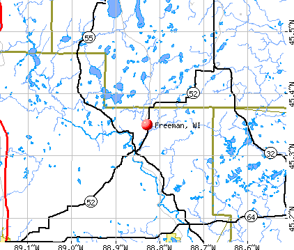
Notable location: Ferryville Volunteer Fire Department (A). Display/hide its location on the map
Churches in Freeman include: West Prairie Church (A), Freeman Church (B). Display/hide their locations on the map
Cemeteries: Ferryville Cemetery (1), Freeman Cemetery (2), Lawrence Ridge Cemetery (3), Rush Creek Cemetery (4), Eitsert Cemetery (5). Display/hide their locations on the map
Lakes and swamps: Chain of Lakes (A), Columbus Lake (B), Winneshiek Bottoms (C). Display/hide their locations on the map
Creeks: Rush Creek (A), Sugar Creek (B), Upper Copper Creek (C), Buck Creek (D). Display/hide their locations on the map
Parks in Freeman include: Rush Creek State Natural Area (1), Sugar Creek Bluff State Natural Area (2). Display/hide their locations on the map
| This town: | 2.2 people |
| Wisconsin: | 2.4 people |
| This town: | 70.2% |
| Whole state: | 64.4% |
| This town: | 5.1% |
| Whole state: | 7.3% |
Likely homosexual households (counted as self-reported same-sex unmarried-partner households)
- Lesbian couples: 0.3% of all households
- Gay men: 0.3% of all households
| This town: | 16.3% |
| Whole state: | 8.7% |
| This town: | 2.0% |
| Whole state: | 3.7% |
For population 15 years and over in Freeman:

- Never married: 22.0%
- Now married: 62.6%
- Separated: 0.9%
- Widowed: 9.0%
- Divorced: 5.5%
For population 25 years and over in Freeman:
- High school or higher: 74.0%
- Bachelor's degree or higher: 12.9%
- Graduate or professional degree: 6.2%
- Unemployed: 2.3%
- Mean travel time to work (commute): 33.1 minutes


| Here: | 12.4 |
| Wisconsin average: | 11.0 |
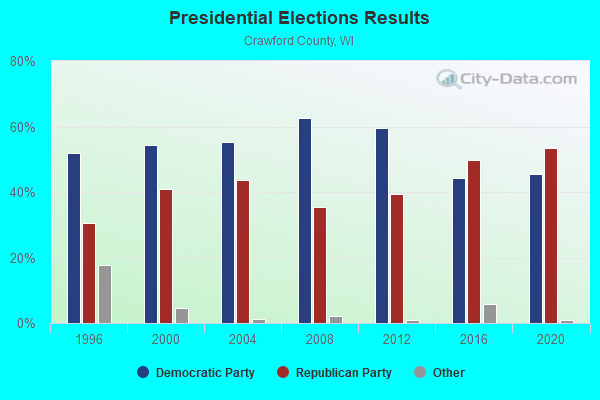
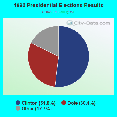
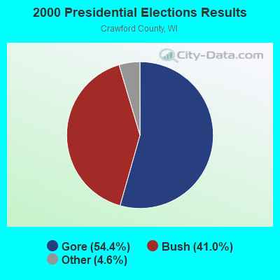
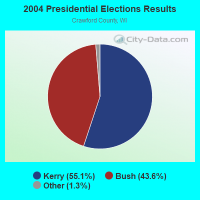
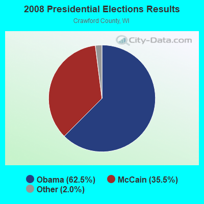

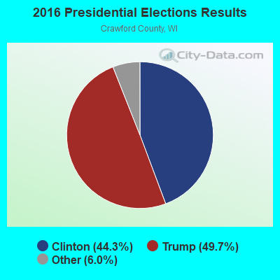

Graphs represent county-level data. Detailed 2008 Election Results
Religion statistics for Freeman, WI (based on Crawford County data)
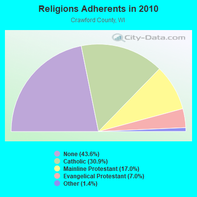
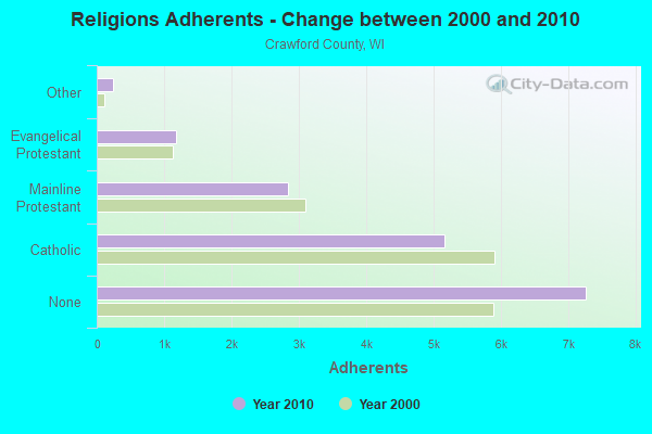
| Religion | Adherents | Congregations |
|---|---|---|
| Catholic | 5,150 | 7 |
| Mainline Protestant | 2,829 | 19 |
| Evangelical Protestant | 1,169 | 10 |
| Other | 237 | 2 |
| None | 7,259 | - |
Food Environment Statistics:
| Crawford County: | 4.13 / 10,000 pop. |
| Wisconsin: | 1.86 / 10,000 pop. |
| Crawford County: | 0.59 / 10,000 pop. |
| State: | 0.11 / 10,000 pop. |
| Here: | 0.59 / 10,000 pop. |
| Wisconsin: | 0.38 / 10,000 pop. |
| Crawford County: | 5.90 / 10,000 pop. |
| State: | 4.12 / 10,000 pop. |
| Crawford County: | 10.03 / 10,000 pop. |
| Wisconsin: | 8.64 / 10,000 pop. |
| Crawford County: | 8.8% |
| Wisconsin: | 7.6% |
| Crawford County: | 26.6% |
| Wisconsin: | 27.5% |
| This county: | 11.3% |
| Wisconsin: | 13.0% |
Strongest AM radio stations in Freeman:
- WKTY (580 AM; 5 kW; LA CROSSE, WI; Owner: FAMILY RADIO, INC.)
- WSPT (1010 AM; 50 kW; STEVENS POINT, WI)
- KNEI (1140 AM; 2 kW; WAUKON, IA; Owner: WENNES COMMUNICATIONS STATIONS, INC.)
- WVRQ (1360 AM; 1 kW; VIROQUA, WI; Owner: ROBINSON CORPORATION)
- KXEL (1540 AM; 50 kW; WATERLOO, IA; Owner: KXEL BROADCASTING COMPANY, INC.)
- WIZM (1410 AM; 5 kW; LA CROSSE, WI; Owner: FAMILY RADIO, INC.)
- WTMJ (620 AM; 50 kW; MILWAUKEE, WI; Owner: JOURNAL BROADCAST CORPORATION)
- WCTS (1030 AM; 50 kW; MAPLEWOOD, MN; Owner: CNTL. BAPT. THEO/AL SEMI MINNEAPOLIS)
- WPRE (980 AM; 1 kW; PRAIRIE DU CHIEN, WI; Owner: ROBINSON CORPORATION)
- WSCR (670 AM; 50 kW; CHICAGO, IL; Owner: INFINITY BROADCASTING OPERATIONS, INC.)
- WNAM (1280 AM; 50 kW; NEENAH-MENASHA, WI; Owner: CUMULUS LICENSING CORP.)
- WKLJ (1290 AM; 5 kW; SPARTA, WI; Owner: SPARTA-TOMAH BROADCASTING CO., INC.)
- WSAU (550 AM; 20 kW; WAUSAU, WI; Owner: WRIG, INC.)
Strongest FM radio stations in Freeman:
- KNEI-FM (103.5 FM; WAUKON, IA; Owner: WENNES COMMUNICATIONS STATIONS, INC.)
- WIZM-FM (93.3 FM; LA CROSSE, WI; Owner: FAMILY RADIO, INC.)
- KQEG (102.7 FM; LA CRESCENT, MN; Owner: WHITE EAGLE BROADCASTING, INC.)
- WQPC (94.3 FM; PRAIRIE DU CHIEN, WI; Owner: ROBINSON CORPORATION)
- WHLA (90.3 FM; LA CROSSE, WI; Owner: STATE OF WISCONSIN - EDUCATIONAL COMMUNICATIONS BOARD)
- WLSU (88.9 FM; LA CROSSE, WI; Owner: BD.OF REGENTS, UNIV.OF WISCONSIN SYSTEM)
- WRQT (95.7 FM; LA CROSSE, WI; Owner: FAMILY RADIO, INC.)
- WVRQ-FM (102.3 FM; VIROQUA, WI; Owner: ROBINSON CORPORATION)
- KOEL-FM (92.3 FM; OELWEIN, IA; Owner: CUMULUS LICENSING CORP.)
- KXLC (91.1 FM; LA CRESCENT, MN; Owner: MINNESOTA PUBLIC RADIO)
- KCLH (94.7 FM; CALEDONIA, MN; Owner: FAMILY RADIO, INC.)
- WLXR-FM (104.9 FM; LA CROSSE, WI; Owner: MISSISSIPPI VALLEY B/CASTERS, L.L.C.)
TV broadcast stations around Freeman:
- K41AD (Channel 41; LANSING, IA; Owner: IOWA PUBLIC BROADCASTING BOARD)
- WDLS-LP (Channel 35; TOMAH, WI; Owner: MAGNUM RADIO, INC.)
- WXOW-TV (Channel 19; LA CROSSE, WI; Owner: WXOW-WQOW TELEVISION, INC.)
- WKBT (Channel 8; LA CROSSE, WI; Owner: QUEENB TELEVISION, LLC)
- WLAX (Channel 25; LA CROSSE, WI; Owner: GRANT MEDIA, INC.)
- WHLA-TV (Channel 31; LA CROSSE, WI; Owner: WISCONSIN EDUCATIONAL COMMUNICATIONS BOARD)
- National Bridge Inventory (NBI) Statistics
- 28Number of bridges
- 420ft / 128mTotal length
- $17,154,000Total costs
- 22,248Total average daily traffic
- 1,328Total average daily truck traffic

- New bridges - historical statistics
- 21930-1939
- 51950-1959
- 41980-1989
- 81990-1999
- 32000-2009
- 62010-2019

- 51.8%Bottled, tank, or LP gas
- 21.1%Wood
- 15.9%Electricity
- 10.4%Fuel oil, kerosene, etc.
- 0.8%Utility gas

- 61.8%Bottled, tank, or LP gas
- 23.6%Electricity
- 14.5%Fuel oil, kerosene, etc.
Freeman compared to Wisconsin state average:
- Unemployed percentage significantly below state average.
- Black race population percentage significantly below state average.
- Hispanic race population percentage significantly below state average.
- Median age significantly above state average.
- Foreign-born population percentage significantly below state average.
- Renting percentage significantly below state average.
- Length of stay since moving in significantly above state average.
- Number of rooms per house significantly below state average.
- House age significantly below state average.
- Percentage of population with a bachelor's degree or higher below state average.