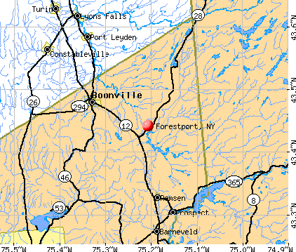
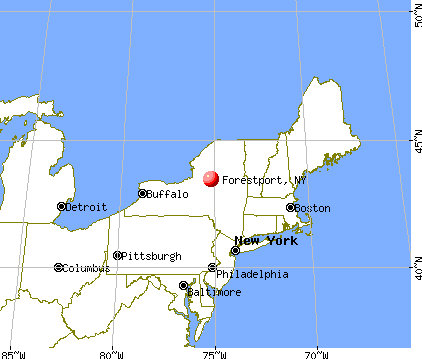
Forestport, New York
Forestport: Black River Forestport, Ny
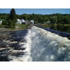
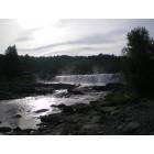
Forestport: view of the forestport dam on 9/5/05
Forestport: Forestport Dam

Forestport: Forestport Dam
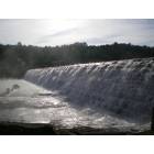
Forestport: Forestport Dam
Forestport: Forestport Dam
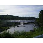
Forestport: Forestport Dam
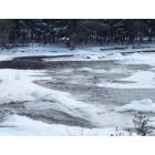
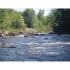
Forestport: Black River

Forestport: Black River

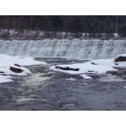
Forestport: Spillway
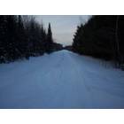
Forestport: Railroad tracks by Buffalo Head Resturaunt
- add
your
Submit your own pictures of this town and show them to the world
- OSM Map
- General Map
- Google Map
- MSN Map
Population change since 2000: -9.3%
 |
| Males: 789 | |
| Females: 746 |
| Median resident age: | 48.5 years |
| New York median age: | 40.7 years |
Zip codes: 13338.
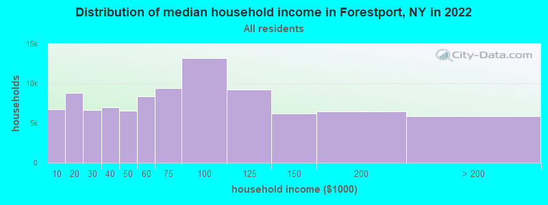
| Forestport: | $61,712 |
| NY: | $79,557 |
Estimated per capita income in 2022: $35,301 (it was $18,494 in 2000)
Forestport town income, earnings, and wages data
Estimated median house or condo value in 2022: $161,936 (it was $70,600 in 2000)
| Forestport: | $161,936 |
| NY: | $400,400 |
Mean prices in 2022: all housing units: $197,131; detached houses: $205,775; townhouses or other attached units: $204,104; in 2-unit structures: $275,728; in 3-to-4-unit structures: $126,003; in 5-or-more-unit structures: $544,387; mobile homes: $61,833
Detailed information about poverty and poor residents in Forestport, NY


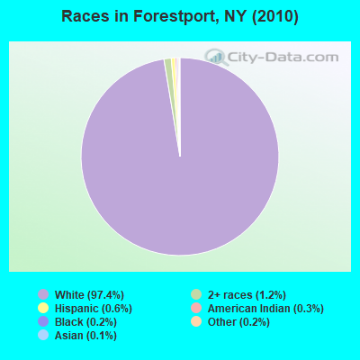
- 1,49597.4%White alone
- 191.2%Two or more races
- 90.6%Hispanic
- 40.3%American Indian alone
- 30.2%Black alone
- 30.2%Other race alone
- 20.1%Asian alone
Races in Forestport detailed stats: ancestries, foreign born residents, place of birth
According to our research of New York and other state lists, there was 1 registered sex offender living in Forestport, New York as of May 09, 2024.
The ratio of all residents to sex offenders in Forestport is 1,535 to 1.
The ratio of registered sex offenders to all residents in this city is lower than the state average.
 Recent articles from our blog. Our writers, many of them Ph.D. graduates or candidates, create easy-to-read articles on a wide variety of topics.

 | "Quaint" communities (43 replies) |
| Moving to Adirondacks from NYC (78 replies) |
| Quasi New England? (36 replies) |
| Adirondacks destinations (9 replies) |
| Ski Resorts & Snowmobiling In New York State (9 replies) |
| Syracuse Chat thread (6339 replies) |
Latest news from Forestport, NY collected exclusively by city-data.com from local newspapers, TV, and radio stations
Ancestries: German (25.4%), Irish (24.4%), English (18.0%), French (10.6%), Italian (10.4%), Welsh (6.3%).
Current Local Time: EST time zone
Elevation: 1220 feet
Land area: 77.2 square miles.
Population density: 20 people per square mile (very low).
22 residents are foreign born
| This town: | 1.3% |
| New York: | 20.4% |
| Forestport town: | 1.4% ($1,022) |
| New York: | 1.9% ($2,847) |
Nearest city with pop. 50,000+: Utica, NY  (26.2 miles , pop. 60,651).
Nearest city with pop. 200,000+: Rochester, NY (124.8 miles , pop. 219,773).
Nearest city with pop. 1,000,000+: Bronx, NY (193.4 miles , pop. 1,332,650).
Nearest cities:
), ), ), ), ), )Latitude: 43.47 N, Longitude: 75.17 W
Area code: 315

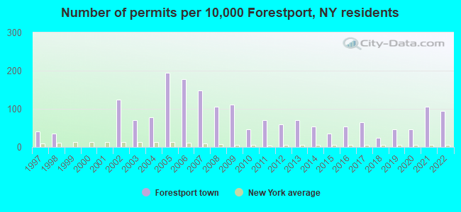
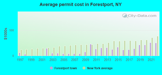
Single-family new house construction building permits:
- 2022: 16 buildings, average cost: $256,300
- 2021: 18 buildings, average cost: $259,200
- 2020: 8 buildings, average cost: $212,500
- 2019: 8 buildings, average cost: $212,500
- 2018: 4 buildings, average cost: $143,800
- 2017: 11 buildings, average cost: $123,200
- 2016: 9 buildings, average cost: $115,600
- 2015: 6 buildings, average cost: $170,800
- 2014: 9 buildings, average cost: $125,000
- 2013: 12 buildings, average cost: $161,500
- 2012: 10 buildings, average cost: $156,200
- 2011: 12 buildings, average cost: $137,800
- 2010: 8 buildings, average cost: $230,000
- 2009: 19 buildings, average cost: $80,000
- 2008: 18 buildings, average cost: $44,000
- 2007: 25 buildings, average cost: $44,000
- 2006: 30 buildings, average cost: $44,000
- 2005: 33 buildings, average cost: $44,000
- 2004: 13 buildings, average cost: $52,700
- 2003: 12 buildings, average cost: $52,700
- 2002: 21 buildings, average cost: $147,500
- 1998: 6 buildings, average cost: $35,000
- 1997: 7 buildings, average cost: $65,000
| Here: | 4.2% |
| New York: | 4.4% |
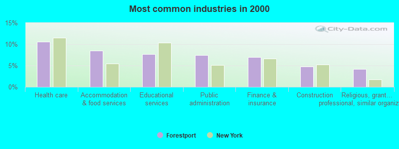
- Health care (10.6%)
- Accommodation & food services (8.5%)
- Educational services (7.7%)
- Public administration (7.5%)
- Finance & insurance (6.9%)
- Construction (4.7%)
- Religious, grantmaking, civic, professional, similar organizations (4.2%)
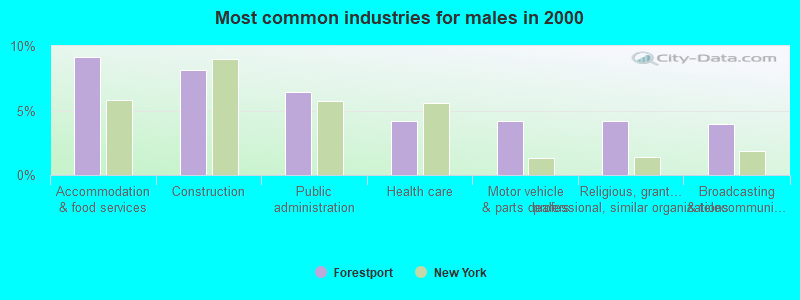
- Accommodation & food services (9.1%)
- Construction (8.1%)
- Public administration (6.4%)
- Health care (4.2%)
- Motor vehicle & parts dealers (4.2%)
- Religious, grantmaking, civic, professional, similar organizations (4.2%)
- Broadcasting & telecommunications (4.0%)

- Health care (17.8%)
- Educational services (12.3%)
- Finance & insurance (11.7%)
- Public administration (8.6%)
- Accommodation & food services (7.8%)
- Social assistance (5.3%)
- Department & other general merchandise stores (5.0%)
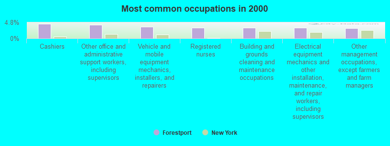
- Cashiers (4.3%)
- Other office and administrative support workers, including supervisors (4.1%)
- Vehicle and mobile equipment mechanics, installers, and repairers (3.5%)
- Registered nurses (3.3%)
- Building and grounds cleaning and maintenance occupations (3.1%)
- Electrical equipment mechanics and other installation, maintenance, and repair workers, including supervisors (3.1%)
- Other management occupations, except farmers and farm managers (3.0%)
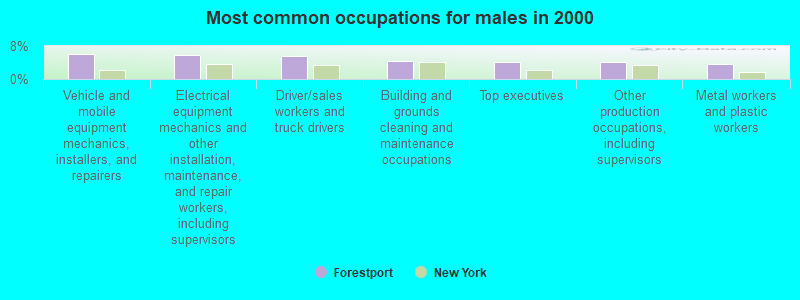
- Vehicle and mobile equipment mechanics, installers, and repairers (6.2%)
- Electrical equipment mechanics and other installation, maintenance, and repair workers, including supervisors (5.9%)
- Driver/sales workers and truck drivers (5.7%)
- Building and grounds cleaning and maintenance occupations (4.4%)
- Top executives (4.2%)
- Other production occupations, including supervisors (4.2%)
- Metal workers and plastic workers (3.7%)
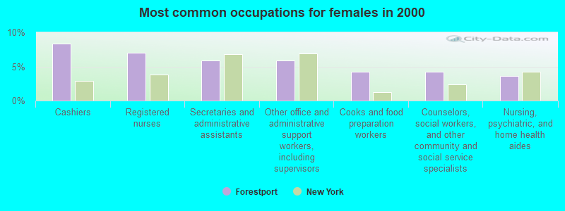
- Cashiers (8.4%)
- Registered nurses (7.0%)
- Secretaries and administrative assistants (5.8%)
- Other office and administrative support workers, including supervisors (5.8%)
- Cooks and food preparation workers (4.2%)
- Counselors, social workers, and other community and social service specialists (4.2%)
- Nursing, psychiatric, and home health aides (3.6%)
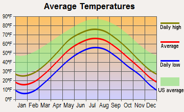
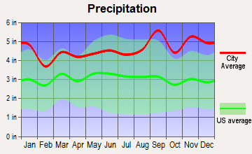
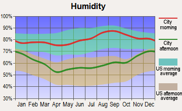
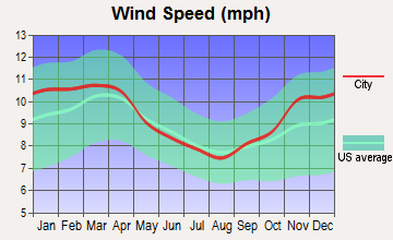
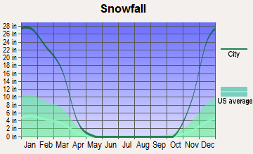
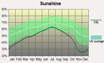
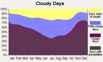
Average climate in Forestport, New York
Based on data reported by over 4,000 weather stations
(lower is better)
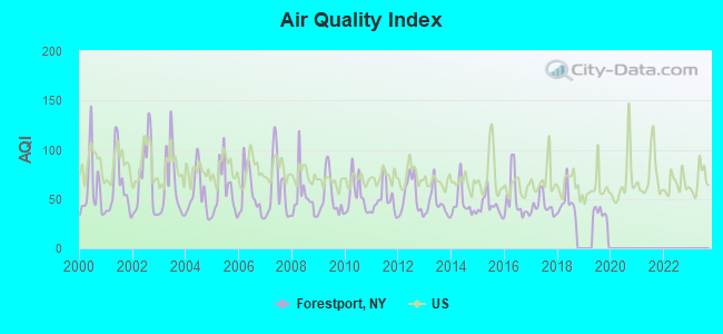
Air Quality Index (AQI) level in 2019 was 32.1. This is significantly better than average.
| City: | 32.1 |
| U.S.: | 72.6 |
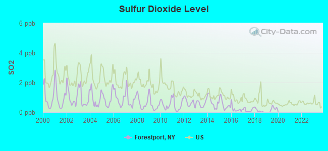
Sulfur Dioxide (SO2) [ppb] level in 2019 was 0.271. This is significantly better than average. Closest monitor was 17.3 miles away from the city center.
| City: | 0.271 |
| U.S.: | 1.515 |
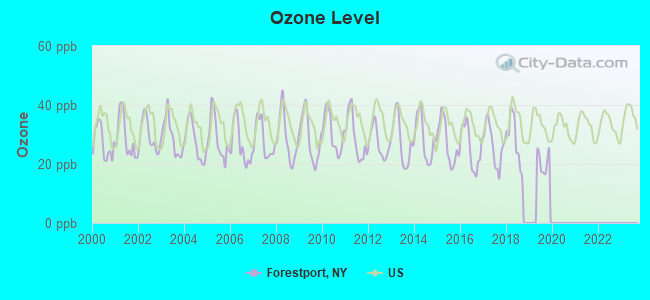
Ozone [ppb] level in 2019 was 20.8. This is significantly better than average. Closest monitor was 17.3 miles away from the city center.
| City: | 20.8 |
| U.S.: | 33.3 |
Tornado activity:
Forestport-area historical tornado activity is below New York state average. It is 80% smaller than the overall U.S. average.
On 5/2/1983, a category F3 (max. wind speeds 158-206 mph) tornado 6.7 miles away from the Forestport town center caused between $5,000,000 and $50,000,000 in damages.
On 7/10/1989, a category F4 (max. wind speeds 207-260 mph) tornado 54.9 miles away from the town center injured 20 people and caused between $5,000,000 and $50,000,000 in damages.
Earthquake activity:
Forestport-area historical earthquake activity is significantly above New York state average. It is 68% smaller than the overall U.S. average.On 10/7/1983 at 10:18:46, a magnitude 5.3 (5.1 MB, 5.3 LG, 5.1 ML, Class: Moderate, Intensity: VI - VII) earthquake occurred 53.0 miles away from Forestport center
On 4/20/2002 at 10:50:47, a magnitude 5.3 (5.3 ML, Depth: 3.0 mi) earthquake occurred 102.6 miles away from Forestport center
On 4/20/2002 at 10:50:47, a magnitude 5.2 (5.2 MB, 4.2 MS, 5.2 MW, 5.0 MW) earthquake occurred 100.6 miles away from the city center
On 1/19/1982 at 00:14:42, a magnitude 4.7 (4.5 MB, 4.7 MD, 4.5 LG, Class: Light, Intensity: IV - V) earthquake occurred 179.0 miles away from the city center
On 6/17/1991 at 08:53:16, a magnitude 4.1 (4.0 MB, 4.0 LG, Depth: 3.1 mi) earthquake occurred 63.3 miles away from the city center
On 9/25/1998 at 19:52:52, a magnitude 5.2 (4.8 MB, 4.3 MS, 5.2 LG, 4.5 MW, Depth: 3.1 mi) earthquake occurred 299.8 miles away from the city center
Magnitude types: regional Lg-wave magnitude (LG), body-wave magnitude (MB), duration magnitude (MD), local magnitude (ML), surface-wave magnitude (MS), moment magnitude (MW)
Natural disasters:
The number of natural disasters in Oneida County (23) is greater than the US average (15).Major Disasters (Presidential) Declared: 12
Emergencies Declared: 9
Causes of natural disasters: Storms: 9, Floods: 7, Tropical Storms: 3, Hurricanes: 2, Snows: 2, Snowstorms: 2, Winds: 2, Blizzard: 1, Ice Storm: 1, Power Outage: 1, Tornado: 1, Winter Storm: 1, Other: 2 (Note: some incidents may be assigned to more than one category).
Colleges/universities with over 2000 students nearest to Forestport:
- Utica College (about 27 miles; Utica, NY; Full-time enrollment: 2,952)
- Mohawk Valley Community College (about 28 miles; Utica, NY; FT enrollment: 5,693)
- Herkimer County Community College (about 32 miles; Herkimer, NY; FT enrollment: 2,774)
- Morrisville State College (about 46 miles; Morrisville, NY; FT enrollment: 2,823)
- Colgate University (about 49 miles; Hamilton, NY; FT enrollment: 3,094)
- Jefferson Community College (about 53 miles; Watertown, NY; FT enrollment: 2,886)
- Le Moyne College (about 55 miles; Syracuse, NY; FT enrollment: 3,041)
Public elementary/middle school in Forestport:
- FORESTPORT ELEMENTARY SCHOOL (Students: 87, Location: 10275 STATE RT 28, Grades: PK-5)
Points of interest:
Notable locations in Forestport: Holiday House (A), Forestport Station (B), Masonic Home Camp (C), Bear Creek Lodge Golf Course (D), Kayuta Lake Campground (E), Camp Russell (F), Forestport Town Wastewater Treatment Plant (G), Camp Nazareth (H), Woodgate Free Library (I), Forestport Fire Fighters (J), Woodgate Volunteer Fire Department (K), Otter Lake Fire Department (L). Display/hide their locations on the map
Cemeteries: Beechwood Cemetery (1), Woodgate Cemetery (2), Catholic Cemetery (3). Display/hide their locations on the map
Lakes, reservoirs, and swamps: Kernan Pond (A), Long Lake (B), Lost Pond (C), Mudhole Pond (D), Round Lake (E), Round Pond (F), Otter Lake (G), White Lake (H). Display/hide their locations on the map
Streams, rivers, and creeks: Gulf Creek (A), Silver Creek (B), Otter Lake Outlet (C), Graham Creek (D), Woodhull Creek (E), Stony Brook (F), Bear Creek (G), White Lake Outlet (H), Pine Creek (I). Display/hide their locations on the map
Drinking water stations with addresses in Forestport and their reported violations in the past:
GARRAMONES RESTAURANT (Address: 11770 O'BRIEN ROAD , Population served: 170, Groundwater):Past monitoring violations:
- 11 routine major monitoring violations
Drinking water stations with addresses in Forestport that have no violations reported:
- KAYUTA LAKE CAMPGROUND (DW) (Address: 10892 CAMPGROUND ROAD , Population served: 256, Primary Water Source Type: Groundwater)
- BUCK-HORN ASSOCIATION (Address: 336 BUCK LANE , Population served: 87, Primary Water Source Type: Groundwater)
- KEVANNA'S COFFEE SHOP (Address: 11915 NYS ROUTE 28 , Population served: 25, Primary Water Source Type: )
| This town: | 2.2 people |
| New York: | 2.6 people |
| This town: | 64.2% |
| Whole state: | 63.5% |
| This town: | 7.0% |
| Whole state: | 6.8% |
Likely homosexual households (counted as self-reported same-sex unmarried-partner households)
- Lesbian couples: 0.6% of all households
- Gay men: 0.0% of all households
| This town: | 8.9% |
| Whole state: | 14.6% |
| This town: | 3.1% |
| Whole state: | 7.4% |
For population 15 years and over in Forestport:
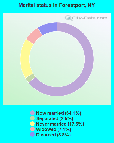
- Never married: 17.6%
- Now married: 64.1%
- Separated: 2.5%
- Widowed: 7.1%
- Divorced: 8.8%
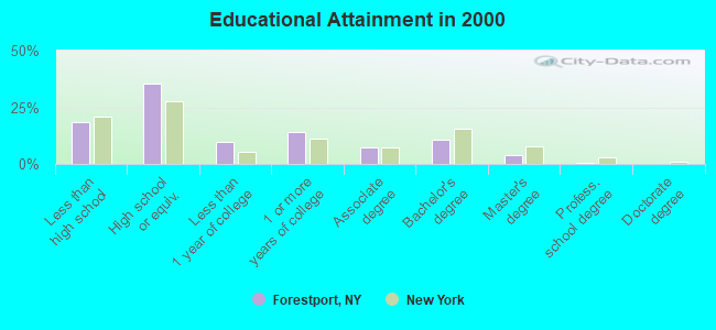
For population 25 years and over in Forestport:
- High school or higher: 81.6%
- Bachelor's degree or higher: 15.0%
- Graduate or professional degree: 4.4%
- Unemployed: 7.1%
- Mean travel time to work (commute): 33.9 minutes
| Here: | 8.9 |
| New York average: | 14.2 |
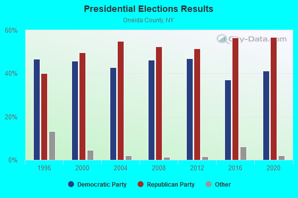
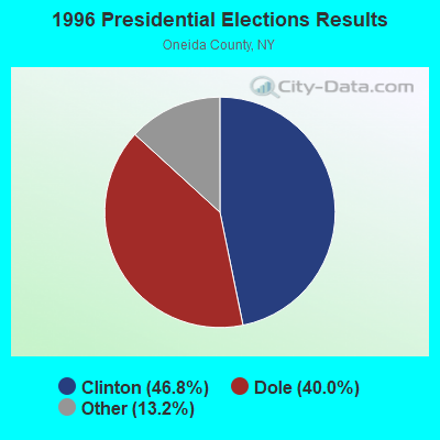
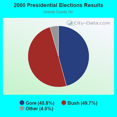
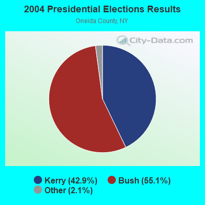
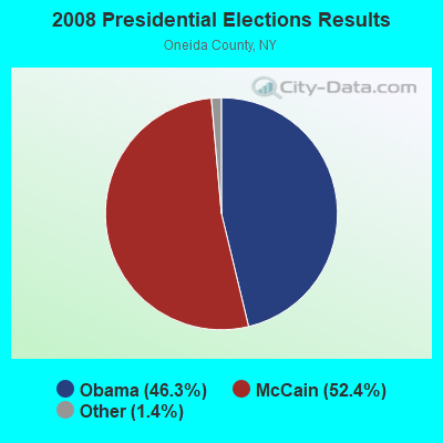
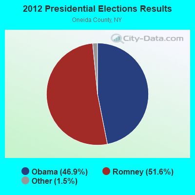
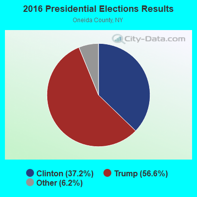
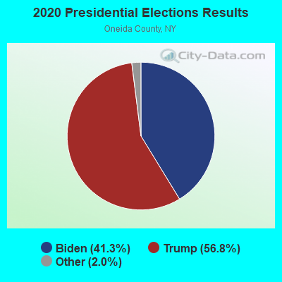
Graphs represent county-level data. Detailed 2008 Election Results
Religion statistics for Forestport, NY (based on Oneida County data)
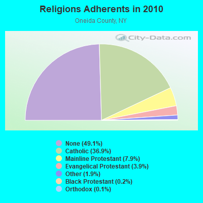
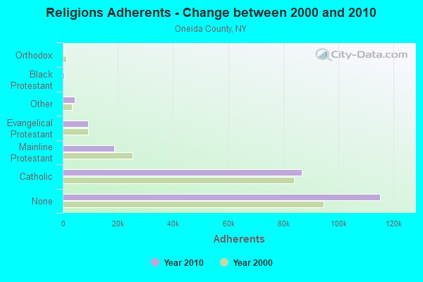
| Religion | Adherents | Congregations |
|---|---|---|
| Catholic | 86,750 | 51 |
| Mainline Protestant | 18,610 | 95 |
| Evangelical Protestant | 9,119 | 75 |
| Other | 4,416 | 16 |
| Black Protestant | 504 | 4 |
| Orthodox | 270 | 3 |
| None | 115,209 | - |
Food Environment Statistics:
| Here: | 2.12 / 10,000 pop. |
| New York: | 4.13 / 10,000 pop. |
| This county: | 0.13 / 10,000 pop. |
| New York: | 0.06 / 10,000 pop. |
| Here: | 0.47 / 10,000 pop. |
| New York: | 0.92 / 10,000 pop. |
| Oneida County: | 3.24 / 10,000 pop. |
| New York: | 1.68 / 10,000 pop. |
| Oneida County: | 8.85 / 10,000 pop. |
| New York: | 8.82 / 10,000 pop. |
| Oneida County: | 8.8% |
| New York: | 8.2% |
| Oneida County: | 24.4% |
| State: | 23.8% |
| Here: | 15.0% |
| New York: | 15.6% |
Strongest AM radio stations in Forestport:
- WADR (1480 AM; 5 kW; REMSEN, NY; Owner: CLEAR CHANNEL BROADCASTING LICENSES, INC.)
- WGY (810 AM; 50 kW; SCHENECTADY, NY; Owner: CLEAR CHANNEL BROADCASTING LICENSES, INC.)
- WBRV (900 AM; 1 kW; BOONVILLE, NY)
- WRUN (1150 AM; 5 kW; UTICA, NY)
- WIBX (950 AM; 5 kW; UTICA, NY; Owner: REGENT LICENSEE OF UTICA/ROME, INC.)
- WPTR (1540 AM; 50 kW; ALBANY, NY; Owner: KIMTRON, INC.)
- WTLB (1310 AM; 5 kW; UTICA, NY; Owner: GALAXY COMMUNICATIONS, L.P.)
- WNNZ (640 AM; 50 kW; WESTFIELD, MA; Owner: CLEAR CHANNEL BROADCASTING LICENSES, INC.)
- WICY (1490 AM; 50 kW; MALONE, NY; Owner: CARTIER COMMUNICATIONS INC.)
- WCHP (760 AM; 35 kW; CHAMPLAIN, NY; Owner: CHAMPLAIN RADIO, INC.)
- WHAM (1180 AM; 50 kW; ROCHESTER, NY; Owner: CITICASTERS LICENSES, L.P.)
- WHEN (620 AM; 5 kW; SYRACUSE, NY; Owner: CLEAR CHANNEL BROADCASTING LICENSES, INC.)
- WSYR (570 AM; 5 kW; SYRACUSE, NY; Owner: CLEAR CHANNEL BROADCASTING LICENSES, INC.)
Strongest FM radio stations in Forestport:
- WUCL (93.5 FM; REMSEN, NY; Owner: CLEAR CHANNEL BROADCASTING LICENSES, INC.)
- WBRV-FM (101.3 FM; BOONVILLE, NY; Owner: THE FLACK BROADCASTING GROUP L.L.C.)
- WOUR (96.9 FM; UTICA, NY; Owner: CLEAR CHANNEL BROADCASTING LICENSES, INC.)
- WUNY (89.5 FM; UTICA, NY; Owner: PUBLIC BC COUNCIL OF CENTRAL NY, INC)
- WLZW (98.7 FM; UTICA, NY; Owner: REGENT LICENSEE OF UTICA/ROME, INC.)
- WXLH (91.3 FM; BLUE MOUNTAIN LAKE, NY; Owner: THE ST. LAWRENCE UNIVERSITY)
- WBGK (99.7 FM; NEWPORT VILLAGE, NY; Owner: ROSER COMMUNICATIONS NETWORK, INC.)
- WBDI (106.7 FM; COPENHAGEN, NY; Owner: FORCE COMMUNICATIONS, INC)
- WODZ-FM (96.1 FM; ROME, NY; Owner: REGENT LICENSEE OF UTICA/ROME, INC.)
- WXLG (89.9 FM; NORTH CREEK, NY; Owner: THE ST. LAWRENCE UNIVERSITY)
- WKLL (94.9 FM; FRANKFORT, NY; Owner: GALAXY COMMUNICATIONS, L.P.)
- WJNY (90.9 FM; WATERTOWN, NY; Owner: PUBLIC B/CNG COUNCIL CENTRAL NY, INC)
- WKVU (100.7 FM; UTICA, NY; Owner: EDUCATIONAL MEDIA FOUNDATION)
- WRCK (107.3 FM; UTICA, NY; Owner: GALAXY COMMUNICATIONS, L.P.)
- WLLG (99.3 FM; LOWVILLE, NY; Owner: THE FLACK BROADCASTING GROUP L.L.C.)
- WSKS (97.9 FM; WHITESBORO, NY; Owner: CLEAR CHANNEL BROADCASTING LICENSES, INC.)
- WRBY (102.5 FM; ROME, NY; Owner: CLEAR CHANNEL BROADCASTING LICENSES, INC.)
- WFRG-FM (104.3 FM; UTICA, NY; Owner: REGENT LICENSEE OF UTICA/ROME, INC.)
TV broadcast stations around Forestport:
- WKTV (Channel 2; UTICA, NY; Owner: SMITH TELEVISION OF NEW YORK LICENSE HOLDINGS, INC.)
- WFXV (Channel 33; UTICA, NY; Owner: QUORUM OF UTICA LICENSE, LLC)
- WWTI (Channel 50; WATERTOWN, NY; Owner: CENTRAL NY NEWS, INC.)
- WSPX-TV (Channel 56; SYRACUSE, NY; Owner: PAXSON SYRACUSE LICENSE, INC.)
- WPBS-TV (Channel 16; WATERTOWN, NY; Owner: ST. LAWRENCE VALLEY EDUCATIONAL TV COUNCIL, INC)
- WUTR (Channel 20; UTICA, NY; Owner: CENTRAL NY NEWS, INC.)
- WPNY-LP (Channel 11; UTICA, ETC., NY; Owner: QUORUM OF UTICA LICENSE, LLC)
- W59AU (Channel 59; UTICA, NY; Owner: PUBLIC B/CING.COUNCIL,CENTRAL N. Y.)
- W53AM (Channel 53; UTICA, NY; Owner: QUORUM OF UTICA LICENSE, LLC)
- W12BZ (Channel 12; ROME, NY; Owner: KEVIN O'KANE)
- Forestport, New York
- Fatal accident count15
- Vehicles involved in fatal accidents19
- Fatal accidents involving drunk persons:8
- Fatalities15
- Persons involved in fatal accidents28
- Pedestrians involved in fatal accidents1
- New York average
- Fatal accident count14916
- Vehicles involved in fatal accidents22332
- Fatal accidents involving drunk persons3194
- Fatalities16088
- Persons involved in fatal accidents36375
- Pedestrians involved in fatal accidents4928
- National Bridge Inventory (NBI) Statistics
- 12Number of bridges
- 85ft / 26.0mTotal length
- $15,837,000Total costs
- 11,004Total average daily traffic
- 993Total average daily truck traffic
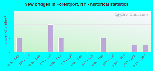
- New bridges - historical statistics
- 21900-1909
- 41930-1939
- 21940-1949
- 21980-1989
- 12010-2019
- 12020-2022
FCC Registered Cell Phone Towers:
1 (See the full list of FCC Registered Cell Phone Towers in Forestport)FCC Registered Antenna Towers:
26 (See the full list of FCC Registered Antenna Towers)FCC Registered Microwave Towers:
4- WOODGATE, 10963 Woodgate Rd (Lat: 43.521111 Lon: -75.162361), Type: Tower, Structure height: 82 m, Overall height: 83.5 m, Call Sign: WPJA719,
Assigned Frequencies: 6680.00 MHz, 6590.00 MHz, Grant Date: 03/08/2011, Expiration Date: 02/01/2021, Cancellation Date: 06/06/2018, Certifier: Carol L Tacker, Registrant: At&t Mobility LLC, 1120 20th Street, Nw - Suite 1000, Washington, DC 20036, Phone: (202) 457-2055, Fax: (202) 457-3073, Email:
- FORESTPORT, 10692 State Route 28 (Lat: 43.448139 Lon: -75.191056), Type: Ltower, Structure height: 76.2 m, Overall height: 80.8 m, Call Sign: WQPA494,
Assigned Frequencies: 10875.0 MHz, 10915.0 MHz, 10995.0 MHz, Grant Date: 04/05/2022, Expiration Date: 03/20/2032, Certifier: Chris Harris, Registrant: Conterra Ultra Broadband, LLC, 2101 Rexford Rd, Ste 200e, Charlotte, NC 28211, Phone: (704) 936-1777, Fax: (704) 936-1801, Email:
- WOODGATE, 10963 Woodgate Road (Lat: 43.521111 Lon: -75.162361), Type: Gtower, Structure height: 82 m, Overall height: 83.5 m, Call Sign: WQRB263,
Assigned Frequencies: 11485.0 MHz, Grant Date: 05/16/2023, Expiration Date: 04/08/2033, Certifier: Chris Harris, Registrant: Conterra Ultra Broadband, LLC, 2101 Rexford Rd, Ste 200e, Charlotte, NC 28211, Phone: (704) 936-1801, Fax: (704) 936-1801, Email:
- UP30146A, 10963 Woodgate Road (Lat: 43.521111 Lon: -75.162361), Type: Gtower, Structure height: 82 m, Overall height: 83.5 m, Call Sign: WRDI622,
Assigned Frequencies: 10815.0 MHz, 10815.0 MHz, 10815.0 MHz, 10815.0 MHz, 10815.0 MHz, 10815.0 MHz, 10815.0 MHz, 10815.0 MHz, 10755.0 MHz, 10755.0 MHz... (+18 more), Grant Date: 05/07/2019, Expiration Date: 05/07/2029, Certifier: David Werblow, Registrant: T-Mobile Usa, Inc., 12920 Se 38th Street, Bellevue, WA 98006, Phone: (425) 383-8401, Fax: (425) 383-4040, Email:
FCC Registered Amateur Radio Licenses:
12 (See the full list of FCC Registered Amateur Radio Licenses in Forestport)FAA Registered Aircraft:
1- Aircraft: PIPER PA-18-135 (Category: Land, Seats: 2, Weight: Up to 12,499 Pounds, Speed: 97 mph), Engine: LYCOMING 0-290 SERIES (140 HP) (Reciprocating)
N-Number: 9964Q, N9964Q, N-9964Q, Serial Number: 18-3956, Airworthiness Date: 07/13/1988, Certificate Issue Date: 08/24/1988
Registrant (Individual): Schneider Nicholas R Ver, 6060 White Lake Rd, Forestport, NY 13338
| Most common first names in Forestport, NY among deceased individuals | ||
| Name | Count | Lived (average) |
|---|---|---|
| John | 13 | 74.7 years |
| William | 12 | 70.2 years |
| Robert | 12 | 67.3 years |
| Joseph | 11 | 73.2 years |
| Arthur | 10 | 76.5 years |
| George | 10 | 84.7 years |
| Mary | 9 | 76.1 years |
| Margaret | 6 | 81.0 years |
| Edward | 5 | 71.4 years |
| Charles | 5 | 73.4 years |
| Most common last names in Forestport, NY among deceased individuals | ||
| Last name | Count | Lived (average) |
|---|---|---|
| Smith | 9 | 76.8 years |
| Roberts | 8 | 68.4 years |
| Mooney | 6 | 63.7 years |
| Quinn | 5 | 79.4 years |
| Ritter | 5 | 69.4 years |
| Gallagher | 4 | 76.5 years |
| Grabauskas | 4 | 76.2 years |
| Johnson | 4 | 80.3 years |
| Peach | 4 | 76.3 years |
| Wood | 4 | 72.2 years |
- 68.2%Fuel oil, kerosene, etc.
- 12.4%Bottled, tank, or LP gas
- 11.0%Wood
- 5.0%Electricity
- 2.0%Utility gas
- 1.4%Other fuel
- 81.7%Fuel oil, kerosene, etc.
- 7.3%Bottled, tank, or LP gas
- 3.7%Utility gas
- 3.7%Wood
- 3.7%No fuel used
Forestport compared to New York state average:
- Median house value significantly below state average.
- Unemployed percentage below state average.
- Black race population percentage significantly below state average.
- Hispanic race population percentage significantly below state average.
- Median age above state average.
- Foreign-born population percentage significantly below state average.
- Renting percentage significantly below state average.
- Length of stay since moving in significantly above state average.
- Number of rooms per house significantly below state average.
- House age significantly below state average.
- Number of college students below state average.
- Percentage of population with a bachelor's degree or higher below state average.