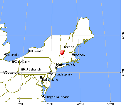
Florida, Massachusetts
Submit your own pictures of this town and show them to the world
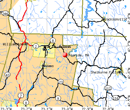
- OSM Map
- General Map
- Google Map
- MSN Map
Population change since 2000: +11.2%
 |
| Males: 386 | |
| Females: 366 |
| Median resident age: | 45.1 years |
| Massachusetts median age: | 39.2 years |
Zip codes: 01247.
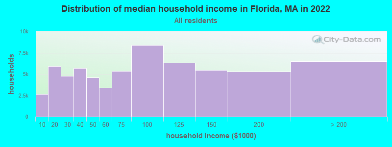
| Florida: | $81,685 |
| MA: | $94,488 |
Estimated per capita income in 2022: $38,084 (it was $16,979 in 2000)
Florida town income, earnings, and wages data
Estimated median house or condo value in 2022: $246,026 (it was $92,000 in 2000)
| Florida: | $246,026 |
| MA: | $534,700 |
Mean prices in 2022: all housing units: $357,971; detached houses: $376,086; townhouses or other attached units: $341,816; in 2-unit structures: $250,940; in 3-to-4-unit structures: $400,871; in 5-or-more-unit structures: $281,990; mobile homes: $80,872
Detailed information about poverty and poor residents in Florida, MA
Compare current foreclosures near Florida, MA:
| Photo | Address | Area | Beds / Baths | Price | Details |
|---|---|---|---|---|---|

|
#1
Elmwood Ave
North Adams, MA 01247
|
2,777 sq. feet
|
3 baths 5 beds |
$215,000
|
show details |

|
#2
Route 2
Shelburne Falls, MA 01370
|
- sq. feet
|
3 baths 6 beds |
$229,900
|
show details |

|
#3
Grove St
Adams, MA 01220
|
2,644 sq. feet
|
2 baths 7 beds |
show details | |

|
#4
Arnold Ct
Cheshire, MA 01225
|
1,600 sq. feet
|
2 baths 2 beds |
show details | |

|
#5
North St
North Adams, MA 01247
|
1,164 sq. feet
|
1 baths 3 beds |
show details | |

|
#6
Houghton St
North Adams, MA 01247
|
1,614 sq. feet
|
2 baths 4 beds |
show details | |

|
#7
Wilshire Dr
Cheshire, MA 01225
|
4,302 sq. feet
|
2 baths 3 beds |
show details | |

|
#8
Franklin St
North Adams, MA 01247
|
1,386 sq. feet
|
1 baths 3 beds |
show details | |

|
#9
North St
Williamstown, MA 01267
|
1,552 sq. feet
|
2 baths 3 beds |
show details | |

|
#10
W Mountain Rd
Adams, MA 01220
|
1,173 sq. feet
|
1 baths 3 beds |
show details |
| Photo | Address | Area | Beds / Baths | Price | Details |
|---|---|---|---|---|---|

|
#11
Loop Rd
Savoy, MA 01256
|
1,040 sq. feet
|
1 baths 3 beds |
show details | |

|
#12
Number 9 Rd
Charlemont, MA 01339
|
2,058 sq. feet
|
2 baths 3 beds |
show details | |

|
#13
Linden St
Williamstown, MA 01267
|
2,298 sq. feet
|
3 baths 4 beds |
show details | |

|
#14
Woodlawn Dr
Williamstown, MA 01267
|
1,806 sq. feet
|
2 baths 4 beds |
show details | |

|
#15
Old North Rd
Worthington, MA 01098
|
2,369 sq. feet
|
3 baths 4 beds |
show details | |

|
#16
Hawley Rd
Ashfield, MA 01330
|
1,008 sq. feet
|
1 baths 3 beds |
show details | |

|
#17
Ashuelot St
Dalton, MA 01226
|
1,792 sq. feet
|
2 baths 3 beds |
show details | |

|
#18
David Dr
Hinsdale, MA 01235
|
1,664 sq. feet
|
2 baths 3 beds |
show details | |

|
#19
Hill Hollow Rd
Petersburg, NY 12138
|
980 sq. feet
|
1 baths 1 beds |
show details | |

|
#20
Rte 9
Windsor, MA 01270
|
1,223 sq. feet
|
1 baths 2 beds |
show details |
| Photo | Address | Area | Beds / Baths | Price | Details |
|---|---|---|---|---|---|

|
#21
Tea St
Charlemont, MA 01339
|
2,829 sq. feet
|
2 baths 6 beds |
show details | |

|
#22
Jacksonville Rd
Colrain, MA 01340
|
1,108 sq. feet
|
1 baths 2 beds |
show details | |

|
#23
North St
Dalton, MA 01226
|
1,852 sq. feet
|
2 baths 4 beds |
show details | |

|
#24
Fox Way
Petersburg, NY 12138
|
1,734 sq. feet
|
1 baths 1 beds |
show details | |

|
#25
Daniels Ct
Adams, MA 01220
|
1,400 sq. feet
|
1 baths 3 beds |
show details | |

|
#26
Church Rd
Drury, MA 01343
|
2,560 sq. feet
|
2 baths 4 beds |
show details | |

|
#27
Valley St
Adams, MA 01220
|
1,680 sq. feet
|
2 baths 4 beds |
show details | |

|
#28
Legate Hill Rd
Charlemont, MA 01339
|
2,016 sq. feet
|
2 baths 3 beds |
show details | |

|
#29
Phelps Rd
North Adams, MA 01247
|
1,286 sq. feet
|
1 baths 4 beds |
show details | |

|
#30
W Shaft Rd
North Adams, MA 01247
|
1,144 sq. feet
|
1 baths 3 beds |
show details |
| Photo | Address | Area | Beds / Baths | Price | Details |
|---|---|---|---|---|---|

|
#31
Mohawk Trl
North Adams, MA 01247
|
1,210 sq. feet
|
1 baths 3 beds |
show details | |

|
#32
Franklin St
North Adams, MA 01247
|
1,386 sq. feet
|
1 baths 3 beds |
show details | |

|
#33
Houghton St
North Adams, MA 01247
|
3,380 sq. feet
|
3 baths 5 beds |
show details | |

|
#34
North St
North Adams, MA 01247
|
1,164 sq. feet
|
1 baths 3 beds |
show details | |

|
#35
Anthony St # B
Adams, MA 01220
|
1,622 sq. feet
|
2 baths 3 beds |
show details | |

|
#36
Baker St
Lanesboro, MA 01237
|
1,231 sq. feet
|
1 baths 3 beds |
show details | |

|
#37
E Hoosac St
Adams, MA 01220
|
594 sq. feet
|
1 baths 2 beds |
show details | |

|
#38
Weber St # 12
Adams, MA 01220
|
1,728 sq. feet
|
2 baths 4 beds |
show details | |

|
#39
Richmond St
Adams, MA 01220
|
1,920 sq. feet
|
2 baths 4 beds |
show details | |

|
#40
Columbia St Apt A
Adams, MA 01220
|
- sq. feet
|
- baths - beds |
show details |
| Photo | Address | Area | Beds / Baths | Price | Details |
|---|---|---|---|---|---|

|
#41
S Main St
Lanesboro, MA 01237
|
- sq. feet
|
- baths - beds |
show details | |

|
#42
Highview Dr Apt C
Pittsfield, MA 01201
|
- sq. feet
|
- baths - beds |
show details | |

|
#43
Main St Apt 2
Bennington, VT 05201
|
- sq. feet
|
- baths - beds |
show details | |

|
#44
Pearl St
Adams, MA 01220
|
- sq. feet
|
- baths - beds |
show details | |

|
#45
Thayer Corner Rd
Cummington, MA 01026
|
- sq. feet
|
- baths - beds |
show details | |

|
#46
Cold Spring Rd
Petersburg, NY 12138
|
- sq. feet
|
- baths - beds |
show details | |

|
#47
Old Cyrus Stage Rd
Rowe, MA 01367
|
- sq. feet
|
- baths - beds |
show details | |

|
#48
Union St # B
North Adams, MA 01247
|
- sq. feet
|
- baths - beds |
show details | |

|
#49
South St
Bennington, VT 05201
|
- sq. feet
|
- baths - beds |
show details | |

|
Check over 1 million property listings on Foreclosure.com!
|
browse all offers | |||

- 72696.5%White alone
- 81.1%Two or more races
- 60.8%Asian alone
- 50.7%Black alone
- 50.7%Hispanic
- 20.3%American Indian alone
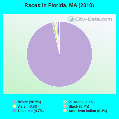
Races in Florida detailed stats: ancestries, foreign born residents, place of birth
 Recent articles from our blog. Our writers, many of them Ph.D. graduates or candidates, create easy-to-read articles on a wide variety of topics.


Latest news from Florida, MA collected exclusively by city-data.com from local newspapers, TV, and radio stations
Ancestries: French (21.7%), English (13.6%), Irish (12.9%), Italian (11.8%), French Canadian (11.1%), United States (9.2%).
Current Local Time: EST time zone
Incorporated in 1805
Elevation: 1895 feet
Land area: 24.4 square miles.
Population density: 31 people per square mile (very low).
8 residents are foreign born
| This town: | 1.2% |
| Massachusetts: | 12.2% |
| Florida town: | 1.0% ($887) |
| Massachusetts: | 1.3% ($2,336) |
Nearest city with pop. 50,000+: Albany, NY  (39.1 miles , pop. 95,658).
Nearest city with pop. 200,000+: Boston, MA (101.1 miles , pop. 589,141).
Nearest city with pop. 1,000,000+: Bronx, NY (134.1 miles , pop. 1,332,650).
Nearest cities:
), ), Latitude: 42.68 N, Longitude: 73.01 W
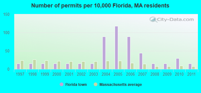
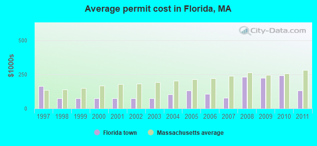
Single-family new house construction building permits:
- 2011: 1 building, cost: $130,000
- 2010: 2 buildings, average cost: $242,500
- 2009: 1 building, cost: $225,000
- 2008: 1 building, cost: $233,300
- 2007: 3 buildings, average cost: $78,300
- 2006: 6 buildings, average cost: $105,600
- 2005: 8 buildings, average cost: $130,500
- 2004: 6 buildings, average cost: $103,600
- 2003: 1 building, cost: $75,000
- 2002: 1 building, cost: $75,000
- 2001: 1 building, cost: $75,000
- 2000: 1 building, cost: $75,000
- 1999: 1 building, cost: $75,000
- 1998: 1 building, cost: $75,000
- 1997: 1 building, cost: $165,000
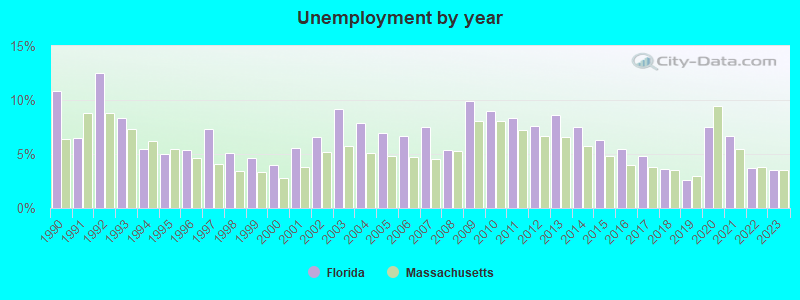
| Here: | 3.5% |
| Massachusetts: | 3.5% |
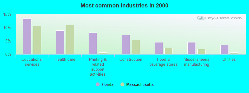
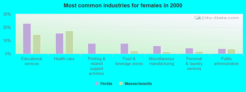
- Educational services (13.5%)
- Health care (9.0%)
- Printing & related support activities (8.1%)
- Construction (7.3%)
- Food & beverage stores (4.5%)
- Miscellaneous manufacturing (4.5%)
- Utilities (3.7%)
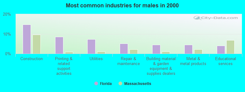
- Construction (14.7%)
- Printing & related support activities (8.5%)
- Utilities (7.3%)
- Repair & maintenance (5.1%)
- Building material & garden equipment & supplies dealers (4.5%)
- Metal & metal products (4.5%)
- Educational services (4.0%)
- Educational services (22.9%)
- Health care (15.6%)
- Printing & related support activities (7.8%)
- Food & beverage stores (7.8%)
- Miscellaneous manufacturing (6.1%)
- Personal & laundry services (4.5%)
- Public administration (3.9%)
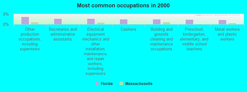
- Other production occupations, including supervisors (6.2%)
- Secretaries and administrative assistants (4.5%)
- Electrical equipment mechanics and other installation, maintenance, and repair workers, including supervisors (4.5%)
- Cashiers (4.2%)
- Building and grounds cleaning and maintenance occupations (4.2%)
- Preschool, kindergarten, elementary, and middle school teachers (3.9%)
- Metal workers and plastic workers (3.7%)
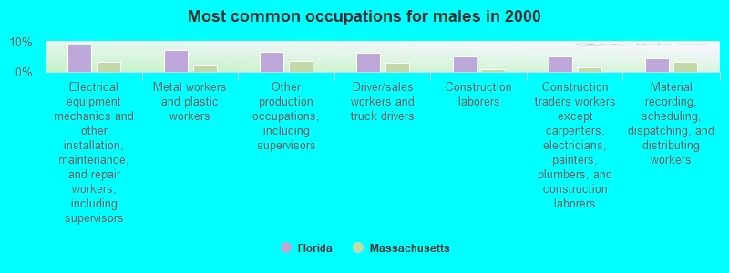
- Electrical equipment mechanics and other installation, maintenance, and repair workers, including supervisors (9.0%)
- Metal workers and plastic workers (7.3%)
- Other production occupations, including supervisors (6.8%)
- Driver/sales workers and truck drivers (6.2%)
- Construction laborers (5.1%)
- Construction traders workers except carpenters, electricians, painters, plumbers, and construction laborers (5.1%)
- Material recording, scheduling, dispatching, and distributing workers (4.5%)

- Secretaries and administrative assistants (8.9%)
- Preschool, kindergarten, elementary, and middle school teachers (7.8%)
- Cashiers (7.3%)
- Other production occupations, including supervisors (5.6%)
- Building and grounds cleaning and maintenance occupations (5.0%)
- Nursing, psychiatric, and home health aides (5.0%)
- Other office and administrative support workers, including supervisors (3.9%)
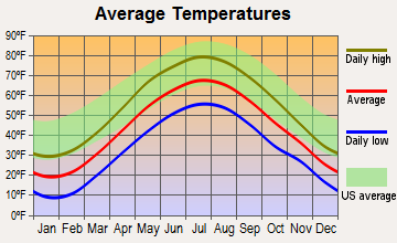
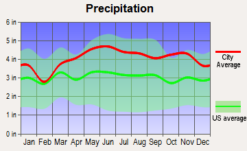
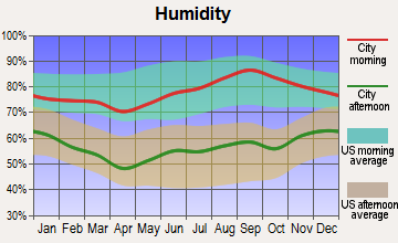
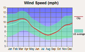
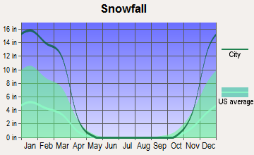
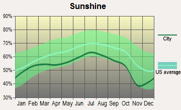
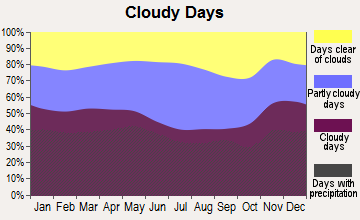
Average climate in Florida, Massachusetts
Based on data reported by over 4,000 weather stations
(lower is better)
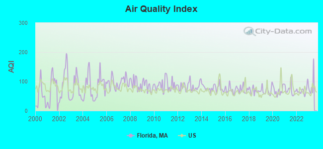
Air Quality Index (AQI) level in 2022 was 69.4. This is about average.
| City: | 69.4 |
| U.S.: | 72.6 |
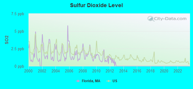
Sulfur Dioxide (SO2) [ppb] level in 2012 was 0.789. This is significantly better than average. Closest monitor was 4.7 miles away from the city center.
| City: | 0.789 |
| U.S.: | 1.515 |
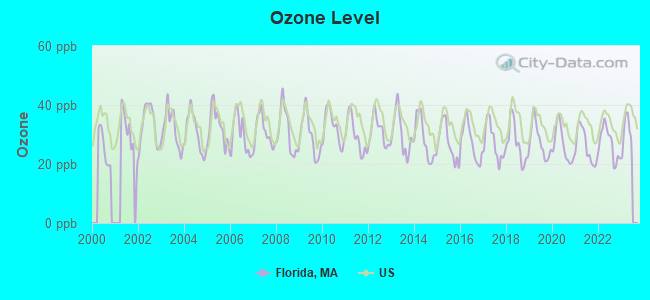
Ozone [ppb] level in 2022 was 27.0. This is better than average. Closest monitor was 14.1 miles away from the city center.
| City: | 27.0 |
| U.S.: | 33.3 |
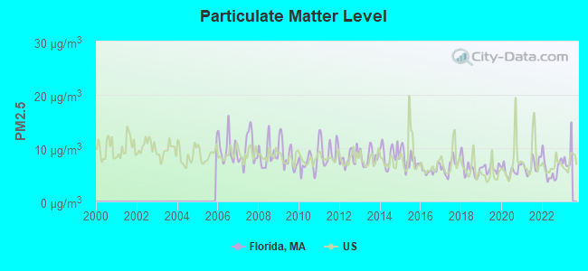
Particulate Matter (PM2.5) [µg/m3] level in 2022 was 5.99. This is better than average. Closest monitor was 5.3 miles away from the city center.
| City: | 5.99 |
| U.S.: | 8.11 |
Tornado activity:
Florida-area historical tornado activity is slightly above Massachusetts state average. It is 23% smaller than the overall U.S. average.
On 8/28/1973, a category F4 (max. wind speeds 207-260 mph) tornado 27.3 miles away from the Florida town center killed 4 people and injured 36 people and caused between $5,000,000 and $50,000,000 in damages.
On 5/29/1995, a category F4 tornado 36.0 miles away from the town center killed 3 people and injured 24 people and caused between $5,000,000 and $50,000,000 in damages.
Earthquake activity:
Florida-area historical earthquake activity is significantly above Massachusetts state average. It is 69% smaller than the overall U.S. average.On 10/7/1983 at 10:18:46, a magnitude 5.3 (5.1 MB, 5.3 LG, 5.1 ML, Class: Moderate, Intensity: VI - VII) earthquake occurred 110.8 miles away from the city center
On 4/20/2002 at 10:50:47, a magnitude 5.3 (5.3 ML, Depth: 3.0 mi) earthquake occurred 131.5 miles away from the city center
On 4/20/2002 at 10:50:47, a magnitude 5.2 (5.2 MB, 4.2 MS, 5.2 MW, 5.0 MW) earthquake occurred 130.1 miles away from the city center
On 1/19/1982 at 00:14:42, a magnitude 4.7 (4.5 MB, 4.7 MD, 4.5 LG, Class: Light, Intensity: IV - V) earthquake occurred 91.3 miles away from Florida center
On 10/16/2012 at 23:12:25, a magnitude 4.7 (4.7 ML, Depth: 10.0 mi) earthquake occurred 134.9 miles away from the city center
On 6/17/1991 at 08:53:16, a magnitude 4.1 (4.0 MB, 4.0 LG, Depth: 3.1 mi) earthquake occurred 84.8 miles away from Florida center
Magnitude types: regional Lg-wave magnitude (LG), body-wave magnitude (MB), duration magnitude (MD), local magnitude (ML), surface-wave magnitude (MS), moment magnitude (MW)
Natural disasters:
The number of natural disasters in Berkshire County (21) is greater than the US average (15).Major Disasters (Presidential) Declared: 10
Emergencies Declared: 10
Causes of natural disasters: Floods: 5, Snowstorms: 5, Storms: 5, Hurricanes: 4, Winter Storms: 4, Blizzards: 2, Snows: 2, Snowfall: 1, Tropical Storm: 1, Wind: 1, Other: 1 (Note: some incidents may be assigned to more than one category).
Hospitals and medical centers near Florida:
- NORTH ADAMS COMMONS NURSING AND REHABILITATION CENTE (Nursing Home, about 5 miles away; NORTH ADAMS, MA)
- ADAMS N H OF N ADAMS (Nursing Home, about 6 miles away; NORTH ADAMS, MA)
- NORTH ADAMS REGIONAL HOSPITAL Acute Care Hospitals (about 6 miles away; NORTH ADAMS, MA)
- NORTHERN BERKSHIRE COMPREHENSIVE CARE (Home Health Center, about 6 miles away; ADAMS, MA)
- HOSPICE OF N BERKSHIRE INC (Hospital, about 6 miles away; ADAMS, MA)
- WILLIAMSTOWN COMMONS NURSING AND REHAB (Nursing Home, about 9 miles away; WILLIAMSTOWN, MA)
- SWEET BROOK OF WILLIAMSTOWN REHABILITATION AND N CTR (Nursing Home, about 12 miles away; WILLIAMSTOWN, MA)
Colleges/universities with over 2000 students nearest to Florida:
- Williams College (about 11 miles; Williamstown, MA; Full-time enrollment: 2,141)
- Smith College (about 32 miles; Northampton, MA; FT enrollment: 3,549)
- University of Massachusetts-Amherst (about 32 miles; Amherst, MA; FT enrollment: 26,583)
- Rensselaer Polytechnic Institute (about 35 miles; Troy, NY; FT enrollment: 6,940)
- Hudson Valley Community College (about 35 miles; Troy, NY; FT enrollment: 9,346)
- The Sage Colleges (about 35 miles; Troy, NY; FT enrollment: 2,499)
- Mount Holyoke College (about 37 miles; South Hadley, MA; FT enrollment: 2,573)
Public elementary/middle school in Florida:
- ABBOTT MEMORIAL (Students: 106, Location: 56 NORTH COUNTY RD, Grades: PK-8)
Points of interest:
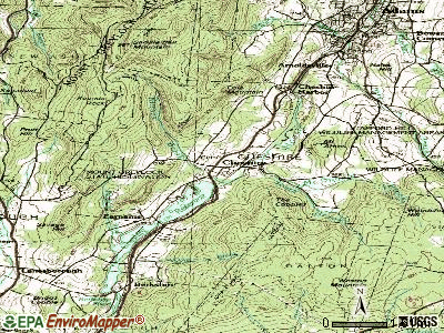
Notable locations in Florida: Roycroft Lookout (A), Florida Volunteer Fire Department Headquarters (B), Florida Town Hall (C). Display/hide their locations on the map
Lakes and reservoirs: Chilson Pond (A), North Pond (B), New Tanks (C), Dunbar Brook Reservoir (D). Display/hide their locations on the map
Streams, rivers, and creeks: Whitcomb Brook (A), Wheeler Brook (B), Smith Brook (C), Reed Brook (D), Manning Brook (E), Hunt Brook (F), Gulf Brook (G), Fife Brook (H), Cascade Brook (I). Display/hide their locations on the map
Park in Florida: Trail Head Picnic Area (1). Display/hide its location on the map
| This town: | 2.4 people |
| Massachusetts: | 2.5 people |
| This town: | 72.1% |
| Whole state: | 63.0% |
| This town: | 9.1% |
| Whole state: | 7.0% |
Likely homosexual households (counted as self-reported same-sex unmarried-partner households)
- Lesbian couples: 0.3% of all households
- Gay men: 1.3% of all households
| This town: | 5.8% |
| Whole state: | 9.3% |
| This town: | 1.0% |
| Whole state: | 4.4% |
For population 15 years and over in Florida:
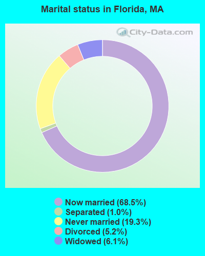
- Never married: 19.3%
- Now married: 68.5%
- Separated: 1.0%
- Widowed: 6.1%
- Divorced: 5.2%
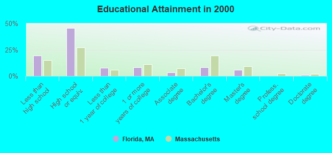
For population 25 years and over in Florida:
- High school or higher: 80.4%
- Bachelor's degree or higher: 15.0%
- Graduate or professional degree: 6.6%
- Unemployed: 2.2%
- Mean travel time to work (commute): 29.2 minutes
| Here: | 10.7 |
| Massachusetts average: | 13.1 |


Graphs represent county-level data. Detailed 2008 Election Results
Religion statistics for Florida, MA (based on Berkshire County data)


| Religion | Adherents | Congregations |
|---|---|---|
| Catholic | 50,187 | 32 |
| Mainline Protestant | 9,895 | 63 |
| Other | 3,647 | 20 |
| Evangelical Protestant | 2,817 | 28 |
| Black Protestant | 233 | 2 |
| Orthodox | 225 | 2 |
| None | 64,215 | - |
Food Environment Statistics:
| This county: | 2.54 / 10,000 pop. |
| State: | 1.98 / 10,000 pop. |
| This county: | 1.61 / 10,000 pop. |
| Massachusetts: | 2.22 / 10,000 pop. |
| Berkshire County: | 4.08 / 10,000 pop. |
| State: | 1.77 / 10,000 pop. |
| Berkshire County: | 15.00 / 10,000 pop. |
| Massachusetts: | 8.76 / 10,000 pop. |
| Here: | 8.0% |
| Massachusetts: | 8.1% |
| Here: | 22.8% |
| Massachusetts: | 22.5% |
| This county: | 9.9% |
| Massachusetts: | 16.5% |
Strongest AM radio stations in Florida:
- WNNZ (640 AM; 50 kW; WESTFIELD, MA; Owner: CLEAR CHANNEL BROADCASTING LICENSES, INC.)
- WNAW (1230 AM; 1 kW; NORTH ADAMS, MA; Owner: BERKSHIRE BROADCASTING CO., INC.)
- WGY (810 AM; 50 kW; SCHENECTADY, NY; Owner: CLEAR CHANNEL BROADCASTING LICENSES, INC.)
- WPTR (1540 AM; 50 kW; ALBANY, NY; Owner: KIMTRON, INC.)
- WCRN (830 AM; 50 kW; WORCESTER, MA; Owner: CARTER BROADCASTING CORPORATION)
- WIZZ (1520 AM; daytime; 10 kW; GREENFIELD, MA; Owner: P. & M. RADIO, LLC)
- WTIC (1080 AM; 50 kW; HARTFORD, CT; Owner: INFINITY RADIO OPERATIONS INC.)
- WVNE (760 AM; daytime; 25 kW; LEICESTER, MA; Owner: BLOUNT MASSCOM, INC.)
- WUHN (1110 AM; daytime; 5 kW; PITTSFIELD, MA; Owner: WEINER BROADCASTING, INC.)
- WRKO (680 AM; 50 kW; BOSTON, MA; Owner: ENTERCOM BOSTON LICENSE, LLC)
- WEEI (850 AM; 50 kW; BOSTON, MA; Owner: ENTERCOM BOSTON LICENSE, LLC)
- WALE (990 AM; 50 kW; GREENVILLE, RI; Owner: NORTH AMERICAN BROADCASTING CO., INC.)
- WHYN (560 AM; 5 kW; SPRINGFIELD, MA; Owner: CLEAR CHANNEL BROADCASTING LICENSES, INC.)
Strongest FM radio stations in Florida:
- WMNB (100.1 FM; NORTH ADAMS, MA; Owner: BERKSHIRE BROADCASTING CO., INC.)
- WAMC-FM (90.3 FM; ALBANY, NY; Owner: WAMC)
- WVAY (100.7 FM; WILMINGTON, VT; Owner: GREAT NORTHERN RADIO, L.L.C.)
- WEQX (102.7 FM; MANCHESTER, VT; Owner: NORTHSHIRE COMMUNICATIONS, INC.)
- WJAN (95.1 FM; SUNDERLAND, VT; Owner: 6 JOHNSON ROAD LICENSES, INC.)
- WZEC (97.5 FM; HOOSICK FALLS, NY; Owner: GREAT NORTHERN RADIO, LLC)
- WPVQ (95.3 FM; GREENFIELD, MA; Owner: GREAT NORTHERN RADIO, L.L.C.)
- WRSY (101.5 FM; MARLBORO, VT; Owner: GREAT NORTHERN RADIO, L.L.C.)
- WJJR (98.1 FM; RUTLAND, VT; Owner: 6 JOHNSON ROAD LICENSES, INC.)
- WZRT (97.1 FM; RUTLAND, VT; Owner: CAPSTAR TX LIMITED PARTNERSHIP)
- WEBK (105.3 FM; KILLINGTON, VT; Owner: 6 JOHNSON ROAD LICENSES, INC.)
- WHDQ (106.1 FM; CLAREMONT, NH; Owner: GREAT NORTHERN RADIO, L.L.C.)
- WVPR (89.5 FM; WINDSOR, VT; Owner: VERMONT PUBLIC RADIO)
- WKVT-FM (92.7 FM; BRATTLEBORO, VT; Owner: SAGA COMMUNICATIONS OF NEW ENGLAND, LLC)
- WBEC-FM (105.5 FM; PITTSFIELD, MA; Owner: GREAT NORTHERN RADIO, LLC)
- WHVP (91.1 FM; HUDSON, NY; Owner: SOUND OF LIFE, INC.)
- WHYN-FM (93.1 FM; SPRINGFIELD, MA; Owner: CLEAR CHANNEL BROADCASTING LICENSES, INC.)
- WUPE (95.9 FM; PITTSFIELD, MA; Owner: WEINER BROADCASTING, INC.)
- WCMK (91.9 FM; PUTNEY, VT; Owner: CHRISTIAN MINISTRIES INC)
- WGLV (91.7 FM; WOODSTOCK, VT; Owner: CHRISTIAN MINISTRIES INC)
TV broadcast stations around Florida:
- WCDC-TV (Channel 19; ADAMS, MA; Owner: YOUNG BROADCASTING OF ALBANY, INC.)
- W38DL (Channel 38; ADAMS, ETC., MA; Owner: WNYT-TV, LLC)
- W35BK (Channel 35; PLAINFIELD, MA; Owner: LYDIA SYLVANE STOCKWELL)
- WNGN-LP (Channel 26; TROY, NY; Owner: BRIAN A. LARSON)
- National Bridge Inventory (NBI) Statistics
- 2Number of bridges
- 20ft / 6.0mTotal length
- $3,091,000Total costs
- 1,796Total average daily traffic
- 168Total average daily truck traffic
- 2,685Total future (year 2032) average daily traffic
FCC Registered Antenna Towers:
5- Sean O'Malley, South Street (Lat: 42.639611 Lon: -72.992333), Type: 57.9, Overall height: 57.9 m, Registrant: Faa/Fcc Compliance Specialist, Bosto-n, Phone: (617) 585-7600
- Sean O'Malley, South Street (Lat: 42.639611 Lon: -72.992333), Type: 57.9, Overall height: 57.9 m, Registrant: Faa/Fcc Compliance Specialist, Bosto-n, Phone: (617) 585-7600
- Sean O'Malley, South Street (010251) (Lat: 42.639611 Lon: -72.992333), Type: 60.6, Overall height: 59.4 m, Registrant: American Tower Management, Inc, Bosto-n, Phone: (617) 585-7600
- Sean O'Malley, South Street (010251) (Lat: 42.639611 Lon: -72.992333), Type: 60.6, Overall height: 59.4 m, Registrant: American Tower Management, Inc, Bosto-n, Phone: (617) 585-7600
- Tim McDougall, South Street (010251) (Lat: 42.639611 Lon: -72.992333), Type: 60.6, Overall height: 59.4 m, Registrant: American Towers, Inc., Bosto-n, Phone: (617) 585-7600
FCC Registered Broadcast Land Mobile Towers:
2- 370 River Road (Lat: 42.719222 Lon: -73.071417), Call Sign: WPMM537,
Assigned Frequencies: 37.8800 MHz, Grant Date: 09/14/2013, Expiration Date: 09/18/2023, Cancellation Date: 11/18/2023, Certifier: Jeffrey M Martin, Registrant: Bear Swamp Power Company, Rowe, MA 01367, Phone: (802) 423-7015, Fax: (802) 423-5363, Email:
- Lat: 42.653722 Lon: -73.040667, Call Sign: WQHH291,
Assigned Frequencies: 159.937 MHz, 160.072 MHz, Grant Date: 06/13/2017, Expiration Date: 07/26/2027, Certifier: Matt Scholl, Registrant: Federal License Management, 1784 E. 3rd Street Suite 269, Williamsport, PA 17701-3862, Phone: (866) 908-2220, Fax: (570) 323-4002, Email:
FCC Registered Microwave Towers:
3- STATION, Deerfield 5 Station On River Rd (Lat: 42.691722 Lon: -72.956750), Overall height: 4 m, Call Sign: WPP93,
Assigned Frequencies: 6755.00 MHz, 6825.00 MHz, Grant Date: 02/04/2020, Expiration Date: 02/08/2030, Registrant: Utilities Technology Council, 2550 South Clark St., Suite 960, Arlington, VA 22202, Phone: (202) 872-0030, Fax: (202) 872-1331, Email:
- Florida, Florida Mountain (Lat: 42.698361 Lon: -73.064556), Type: Tower, Structure height: 48.8 m, Call Sign: WPQW551, Licensee ID: L00129200,
Assigned Frequencies: 10835.0 MHz, 5945.20 MHz, 5974.85 MHz, 6004.50 MHz, 6034.15 MHz, Grant Date: 10/23/2000, Expiration Date: 10/23/2010, Cancellation Date: 10/21/2008, Certifier: Michael J Shortley Iii, Registrant: Equal Access Networks, LLC
- Florida Mountain, Tower Site At Florida Mountain (Lat: 42.697500 Lon: -73.064444), Type: Nntann, Structure height: 33.3 m, Call Sign: WPRV200, Licensee ID: L00129200,
Assigned Frequencies: 11125.0 MHz, Grant Date: 02/09/2001, Expiration Date: 02/09/2011, Cancellation Date: 10/21/2008, Certifier: Michael J Shortley Iii, Registrant: Equal Access Networks, LLC
FCC Registered Amateur Radio Licenses:
2- Call Sign: KB1EQU, Licensee ID: L00182632, Grant Date: 12/09/1999, Expiration Date: 12/09/2009, Cancellation Date: 12/10/2011, Certifier: Craig A Gentes, Registrant: Craig A Gentes, 47 Central Shaft Rd, Florida, MA 01247
- Call Sign: KC1IYE, Licensee ID: L02159881, Grant Date: 02/02/2018, Expiration Date: 02/02/2028, Cancellation Date: 05/01/2018, Certifier: Stephen M Miceli, Registrant: Stephen M Miceli, 23 Savoy Rd, Florida, MA 01247
FAA Registered Aircraft:
1- Aircraft: TAYLORCRAFT A (Category: Land, Seats: 2, Weight: Up to 12,499 Pounds, Speed: 69 mph), Engine: CONT MOTOR A50 SERIES (50 HP) (Reciprocating)
N-Number: 20304, N20304, N-20304, Serial Number: 405, Year manufactured: 1937, Airworthiness Date: 11/24/1956, Certificate Issue Date: 12/12/2011
Registrant (Individual): Derek E Rougeau, 27 Savoy Rd, Florida, MA 01247
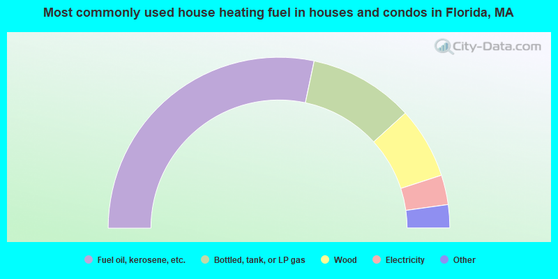
- 56.6%Fuel oil, kerosene, etc.
- 19.9%Bottled, tank, or LP gas
- 13.5%Wood
- 5.6%Electricity
- 2.8%Other fuel
- 1.6%Coal or coke
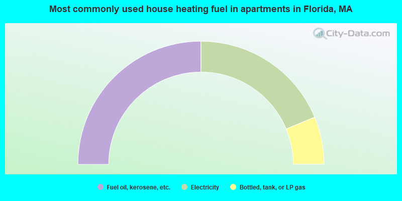
- 50.0%Fuel oil, kerosene, etc.
- 37.5%Electricity
- 12.5%Bottled, tank, or LP gas
Florida compared to Massachusetts state average:
- Median house value below state average.
- Unemployed percentage significantly below state average.
- Black race population percentage significantly below state average.
- Hispanic race population percentage significantly below state average.
- Median age above state average.
- Foreign-born population percentage significantly below state average.
- Renting percentage significantly below state average.
- Length of stay since moving in significantly above state average.
- Number of rooms per house significantly below state average.
- House age significantly below state average.
- Number of college students below state average.
- Percentage of population with a bachelor's degree or higher below state average.