Fedscreek, Kentucky
Submit your own pictures of this place and show them to the world
- OSM Map
- General Map
- Google Map
- MSN Map

| Males: 1,912 | |
| Females: 1,872 |
| Median resident age: | 36.9 years |
| Kentucky median age: | 35.9 years |
Zip code: 41554
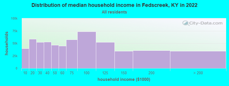
| Fedscreek: | $36,648 |
| KY: | $59,341 |
Estimated per capita income in 2022: $19,952 (it was $10,957 in 2000)
Fedscreek CCD income, earnings, and wages data
Estimated median house or condo value in 2022: $92,802 (it was $42,400 in 2000)
| Fedscreek: | $92,802 |
| KY: | $196,300 |
Detailed information about poverty and poor residents in Fedscreek, KY
Compare current foreclosures near Fedscreek, KY:
| Photo | Address | Area | Beds / Baths | Price | Details |
|---|---|---|---|---|---|

|
#1
Red Creek Rd
Pikeville, KY 41501
|
948 sq. feet
|
1 baths 3 beds |
$25,900
|
show details |

|
#2
N Levisa Rd
Mouthcard, KY 41548
|
- sq. feet
|
1 baths 3 beds |
show details | |

|
#3
Lakeview Cir
Pikeville, KY 41501
|
2,430 sq. feet
|
4 baths 4 beds |
show details | |

|
#4
Yates St
Grundy, VA 24614
|
3,055 sq. feet
|
3 baths 5 beds |
show details | |

|
#5
Rosiland St
Pikeville, KY 41501
|
1,782 sq. feet
|
2 baths 3 beds |
show details | |

|
#6
Fonso Stanley Rd
Canada, KY 41519
|
- sq. feet
|
- baths - beds |
$14,900
|
show details |

|
#7
Meathouse Frk
Canada, KY 41519
|
2,163 sq. feet
|
1 baths 4 beds |
show details | |

|
#8
Lick Frk
Pikeville, KY 41501
|
1,296 sq. feet
|
2 baths 3 beds |
show details | |

|
#9
Chloe Rd
Pikeville, KY 41501
|
1,248 sq. feet
|
1 baths 2 beds |
show details | |

|
#10
Carter Dr
Pikeville, KY 41501
|
1,322 sq. feet
|
2 baths 2 beds |
show details |
| Photo | Address | Area | Beds / Baths | Price | Details |
|---|---|---|---|---|---|

|
#11
Flanary Br
Mouthcard, KY 41548
|
- sq. feet
|
2 baths 4 beds |
show details | |

|
#12
Big Card Rd
Mouthcard, KY 41548
|
800 sq. feet
|
1 baths 2 beds |
show details | |

|
#13
Left Turkey Toe Br
Hardy, KY 41531
|
- sq. feet
|
- baths - beds |
$29,900
|
show details |

|
#14
Justice Holw
Freeburn, KY 41528
|
1,836 sq. feet
|
2 baths 3 beds |
show details | |

|
#15
Marrowbone Creek Rd
Elkhorn City, KY 41522
|
1,188 sq. feet
|
1 baths 3 beds |
show details | |

|
#16
Greasy Crk
Shelbiana, KY 41562
|
1,152 sq. feet
|
1 baths 3 beds |
show details | |

|
#17
Calf Br
Ransom, KY 41558
|
864 sq. feet
|
1 baths 2 beds |
show details | |

|
#18
Smith Frk
Ransom, KY 41558
|
1,325 sq. feet
|
1 baths 2 beds |
show details | |

|
#19
State Highway 194 E
Kimper, KY 41539
|
3,236 sq. feet
|
2 baths 3 beds |
show details | |

|
#20
6th St
Pikeville, KY 41501
|
1,508 sq. feet
|
5 baths 6 beds |
show details |
| Photo | Address | Area | Beds / Baths | Price | Details |
|---|---|---|---|---|---|

|
#21
Bowling Fork Rd
Elkhorn City, KY 41522
|
1,152 sq. feet
|
1 baths 3 beds |
show details | |

|
#22
Atkins Belcher Rd
Elkhorn City, KY 41522
|
1,924 sq. feet
|
1 baths 2 beds |
show details | |

|
#23
N Douglas Ct
Pikeville, KY 41501
|
2,216 sq. feet
|
2 baths 3 beds |
show details | |

|
#24
Left Fork Old House Br
Ransom, KY 41558
|
1,600 sq. feet
|
1 baths 2 beds |
show details | |

|
#25
Clevinger Br
Pikeville, KY 41501
|
1,092 sq. feet
|
1 baths 3 beds |
show details | |

|
#26
Us Highway 119 N
Belfry, KY 41514
|
2,162 sq. feet
|
1 baths 2 beds |
show details | |

|
#27
Caney Newsome Br
Pikeville, KY 41501
|
1,294 sq. feet
|
2 baths 2 beds |
show details | |

|
#28
Smith Fork Rd
Phelps, KY 41553
|
1,252 sq. feet
|
2 baths 3 beds |
show details | |

|
#29
Powells Crk
Pikeville, KY 41501
|
1,392 sq. feet
|
1 baths 3 beds |
show details | |

|
#30
Rakes Ridge Rd
Birchleaf, VA 24220
|
1,566 sq. feet
|
2 baths 3 beds |
show details |
| Photo | Address | Area | Beds / Baths | Price | Details |
|---|---|---|---|---|---|

|
#31
Thacker Holw
Canada, KY 41519
|
- sq. feet
|
- baths - beds |
show details | |

|
#32
Carter Dr
Pikeville, KY 41501
|
- sq. feet
|
- baths - beds |
show details | |

|
#33
Amos Newsome Ln
Virgie, KY 41572
|
- sq. feet
|
- baths - beds |
show details | |

|
#34
Magic Rd
Vansant, VA 24656
|
- sq. feet
|
- baths - beds |
show details | |

|
#35
Jackson Branch Rd
Elkhorn City, KY 41522
|
- sq. feet
|
- baths - beds |
show details | |

|
#36
Frogtown Rd
Pikeville, KY 41501
|
- sq. feet
|
- baths - beds |
show details | |

|
#37
Pauley Holw
Forest Hills, KY 41527
|
- sq. feet
|
- baths - beds |
show details | |

|
#38
Poplar Creek Rd
Grundy, VA 24614
|
- sq. feet
|
- baths - beds |
show details | |

|
#39
Little Crk
Pikeville, KY 41501
|
- sq. feet
|
- baths - beds |
show details | |

|
#40
Forest Hills Rd
Forest Hills, KY 41527
|
- sq. feet
|
- baths - beds |
show details |
| Photo | Address | Area | Beds / Baths | Price | Details |
|---|---|---|---|---|---|

|
#41
Coal Hollow Road
Pikeville, KY 41501
|
- sq. feet
|
- baths - beds |
show details | |

|
#42
Marrowbone Creek Rd
Elkhorn City, KY 41522
|
1,664 sq. feet
|
- baths - beds |
show details | |

|
#43
Bruce Elliott Dr
Pikeville, KY 41501
|
- sq. feet
|
- baths - beds |
show details | |

|
#44
Banyon Rd
Grundy, VA 24614
|
- sq. feet
|
- baths - beds |
show details | |

|
#45
Peter Fork Rd
Mc Carr, KY 41544
|
- sq. feet
|
- baths - beds |
show details | |

|
#46
Us Highway 23 S
Pikeville, KY 41501
|
- sq. feet
|
- baths - beds |
show details | |

|
#47
Cumberland Ct
Pikeville, KY 41501
|
2,070 sq. feet
|
- baths - beds |
show details | |

|
#48
Forest Hills Rd
Forest Hills, KY 41527
|
- sq. feet
|
- baths - beds |
show details | |

|
#49
Us Highway 119 N
Belfry, KY 41514
|
- sq. feet
|
- baths - beds |
show details | |

|
Check over 1 million property listings on Foreclosure.com!
|
browse all offers | |||

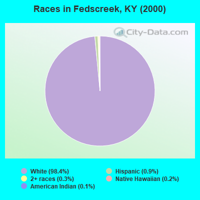
- 3,89498.4%White alone
- 340.9%Hispanic
- 130.3%Two or more races
- 60.2%Native Hawaiian and Other
Pacific Islander alone - 50.1%American Indian alone
- 30.08%Black alone
- 10.03%Asian alone
Races in Fedscreek detailed stats: ancestries, foreign born residents, place of birth
 Recent articles from our blog. Our writers, many of them Ph.D. graduates or candidates, create easy-to-read articles on a wide variety of topics.
Current Local Time: EST time zone
Land area: 85.6 square miles.
Population density: 44 people per square mile (very low).

| Fedscreek CCD: | 0.8% ($326) |
| Kentucky: | 0.8% ($610) |
Nearest city with pop. 50,000+: Huntington, WV  (69.6 miles , pop. 51,475).
Nearest city with pop. 200,000+: Fayette, KY (128.8 miles , pop. 260,512).
Nearest city with pop. 1,000,000+: Chicago, IL (420.2 miles , pop. 2,896,016).
Nearest cities:
), ), ), ), ), )Latitude: 37.41 N, Longitude: 82.27 W
Area code: 606

| Here: | 5.3% |
| Kentucky: | 3.8% |
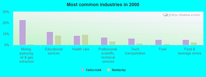
- Mining, quarrying, oil & gas extraction (22.9%)
- Educational services (12.0%)
- Health care (8.6%)
- Professional, scientific, technical services (7.0%)
- Truck transportation (6.1%)
- Food (4.9%)
- Food & beverage stores (4.8%)
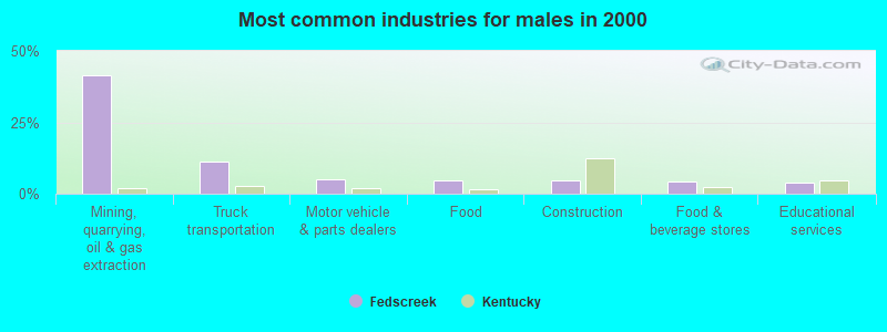
- Mining, quarrying, oil & gas extraction (41.5%)
- Truck transportation (11.4%)
- Motor vehicle & parts dealers (4.9%)
- Food (4.8%)
- Construction (4.6%)
- Food & beverage stores (4.4%)
- Educational services (3.9%)
- Educational services (21.4%)
- Health care (16.1%)
- Professional, scientific, technical services (11.2%)
- Accommodation & food services (6.3%)
- Food & beverage stores (5.3%)
- Food (5.1%)
- Finance & insurance (5.1%)
- Driver/sales workers and truck drivers (8.9%)
- Extraction workers (8.0%)
- Cooks and food preparation workers (4.8%)
- Construction traders workers except carpenters, electricians, painters, plumbers, and construction laborers (4.7%)
- Laborers and material movers, hand (4.1%)
- Building and grounds cleaning and maintenance occupations (3.8%)
- Vehicle and mobile equipment mechanics, installers, and repairers (3.7%)
- Driver/sales workers and truck drivers (16.7%)
- Extraction workers (15.0%)
- Construction traders workers except carpenters, electricians, painters, plumbers, and construction laborers (8.8%)
- Vehicle and mobile equipment mechanics, installers, and repairers (7.0%)
- Laborers and material movers, hand (5.8%)
- Electrical equipment mechanics and other installation, maintenance, and repair workers, including supervisors (4.6%)
- Other material moving workers, except laborers (4.1%)

- Cooks and food preparation workers (9.4%)
- Building and grounds cleaning and maintenance occupations (6.7%)
- Information and record clerks, except customer service representatives (5.7%)
- Teachers, secondary school (5.5%)
- Secretaries and administrative assistants (5.3%)
- Health technologists and technicians (4.7%)
- Cashiers (4.5%)
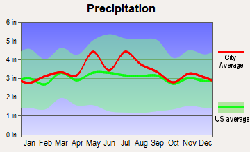
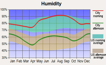
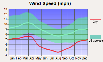
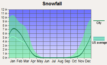
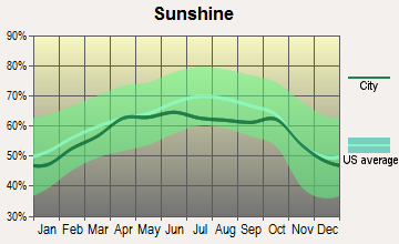
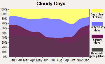
Average climate in Fedscreek, Kentucky
Based on data reported by over 4,000 weather stations
(lower is better)
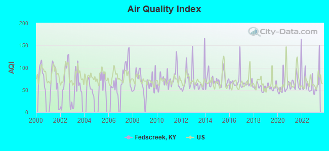
Air Quality Index (AQI) level in 2022 was 60.7. This is about average.
| City: | 60.7 |
| U.S.: | 72.6 |
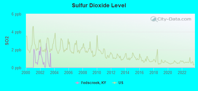
Sulfur Dioxide (SO2) [ppb] level in 2002 was 1.08. This is significantly better than average. Closest monitor was 14.5 miles away from the city center.
| City: | 1.08 |
| U.S.: | 1.51 |
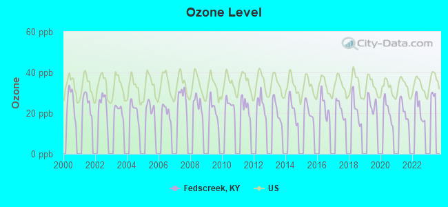
Ozone [ppb] level in 2022 was 21.9. This is significantly better than average. Closest monitor was 14.5 miles away from the city center.
| City: | 21.9 |
| U.S.: | 33.3 |
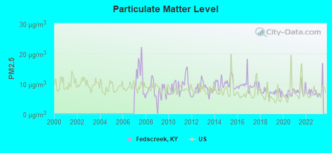
Particulate Matter (PM2.5) [µg/m3] level in 2022 was 6.97. This is about average. Closest monitor was 15.2 miles away from the city center.
| City: | 6.97 |
| U.S.: | 8.11 |
Earthquake activity:
Fedscreek-area historical earthquake activity is significantly above Kentucky state average. It is 16% greater than the overall U.S. average.On 7/27/1980 at 18:52:21, a magnitude 5.2 (5.1 MB, 4.7 MS, 5.0 UK, 5.2 UK, Class: Moderate, Intensity: VI - VII) earthquake occurred 106.4 miles away from Fedscreek center
On 8/9/2020 at 12:07:37, a magnitude 5.1 (5.1 MW, Depth: 4.7 mi) earthquake occurred 92.0 miles away from Fedscreek center
On 8/23/2011 at 17:51:04, a magnitude 5.8 (5.8 MW, Depth: 3.7 mi) earthquake occurred 239.8 miles away from the city center
On 11/23/2006 at 10:42:57, a magnitude 4.3 (4.3 MB, Class: Light, Intensity: IV - V) earthquake occurred 24.2 miles away from Fedscreek center
On 11/2/2006 at 17:53:02, a magnitude 4.3 (4.3 MB, Depth: 0.6 mi) earthquake occurred 24.4 miles away from Fedscreek center
On 9/7/1988 at 02:28:09, a magnitude 4.6 (4.5 MB, 4.6 LG) earthquake occurred 101.2 miles away from Fedscreek center
Magnitude types: regional Lg-wave magnitude (LG), body-wave magnitude (MB), surface-wave magnitude (MS), moment magnitude (MW)
Natural disasters:
The number of natural disasters in Pike County (38) is a lot greater than the US average (15).Major Disasters (Presidential) Declared: 30
Emergencies Declared: 2
Causes of natural disasters: Floods: 28, Storms: 25, Mudslides: 12, Tornadoes: 9, Landslides: 7, Winter Storms: 4, Fires: 3, Snowstorms: 2, Winds: 2, Blizzard: 1, Flash Flood: 1, Heavy Rain: 1, Hurricane: 1, Snow: 1, Snowfall: 1, Other: 1 (Note: some incidents may be assigned to more than one category).
Hospitals and medical centers near Fedscreek:
- GOOD SHEPHERD COMMUNITY NURSING CENTER (Nursing Home, about 10 miles away; PHELPS, KY)
- MOUNTAIN VIEW HEALTH CARE CENTER (Nursing Home, about 10 miles away; ELKHORN CITY, KY)
- HOME CARE HEALTH SERVICES, INC (Home Health Center, about 14 miles away; PIKEVILLE, KY)
- HOSPICE OF PIKE COUNTY (Hospital, about 14 miles away; PIKEVILLE, KY)
- PIKEVILLE MEDICAL CENTER HOME HEALTH AGENCY (Home Health Center, about 15 miles away; PIKEVILLE, KY)
- PIKEVILLE MEDICAL CENTER Acute Care Hospitals (about 15 miles away; PIKEVILLE, KY)
- PARKVIEW NURSING AND REHABILITATION CENTER (Nursing Home, about 15 miles away; PIKEVILLE, KY)
Colleges/universities with over 2000 students nearest to Fedscreek:
- Big Sandy Community and Technical College (about 34 miles; Prestonsburg, KY; Full-time enrollment: 2,660)
- Southeast Kentucky Community and Technical College (about 51 miles; Cumberland, KY; FT enrollment: 2,196)
- Hazard Community and Technical College (about 52 miles; Hazard, KY; FT enrollment: 2,087)
- King University (about 58 miles; Bristol, TN; FT enrollment: 2,472)
- New River Community and Technical College (about 64 miles; Beckley, WV; FT enrollment: 2,234)
- Northeast State Community College (about 65 miles; Blountville, TN; FT enrollment: 4,480)
- Concord University (about 70 miles; Athens, WV; FT enrollment: 2,698)
Public elementary/middle school in Fedscreek:
- FEDS CREEK ELEMENTARY SCHOOL (Students: 306, Location: 221 FEDS CREEK RD, Grades: PK-8)
Points of interest:
Notable locations in Fedscreek: Rowland Row Camp (A), Lick Creek Station (B), Camp Evangel (C), Kimper Volunteer Fire Department Station 4 (D), Fedscreek Volunteer Fire Department Station 2 (E), Grapevine Volunteer Fire Department (F), Feds Creek Volunteer Fire Department (G). Display/hide their locations on the map
Churches in Fedscreek include: Little Union Church (A), Mountain View Church (B), Mouthcard Baptist Church (C), Card Creek Church (D). Display/hide their locations on the map
Cemeteries: Hackney Creek Cemetery (1), Childress Cemetery (2), Rose Cemetery (3), Anderson Cemetery (4), Flanary Cemetery (5), Good Cemetery (6), Hunt Cemetery (7). Display/hide their locations on the map
Reservoir: Fishtrap Lake (A). Display/hide its location on the map
Streams, rivers, and creeks: Dry Fork (A), Becky Branch (B), Big Creek (C), Miletree Branch (D), Blueford Fork (E), Crooked Branch (F), Wolfpen Branch (G), Upper Camp Branch (H), Turkeypen Fork (I). Display/hide their locations on the map
| This place: | 2.4 people |
| Kentucky: | 2.5 people |
| This place: | 70.8% |
| Whole state: | 66.9% |
| This place: | 4.6% |
| Whole state: | 6.4% |
Likely homosexual households (counted as self-reported same-sex unmarried-partner households)
- Lesbian couples: 0.2% of all households
- Gay men: 0.2% of all households
| This place: | 26.6% |
| Whole state: | 15.8% |
| This place: | 13.3% |
| Whole state: | 6.6% |
For population 15 years and over in Fedscreek:
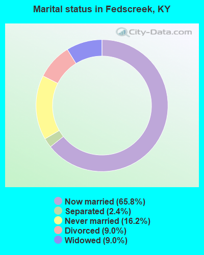
- Never married: 16.2%
- Now married: 65.8%
- Separated: 2.4%
- Widowed: 9.0%
- Divorced: 9.0%
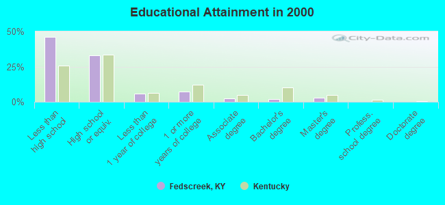
For population 25 years and over in Fedscreek:
- High school or higher: 54.1%
- Bachelor's degree or higher: 5.2%
- Graduate or professional degree: 3.2%
- Unemployed: 9.6%
- Mean travel time to work (commute): 34.8 minutes

| Here: | 16.1 |
| Kentucky average: | 13.8 |

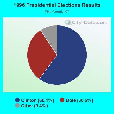
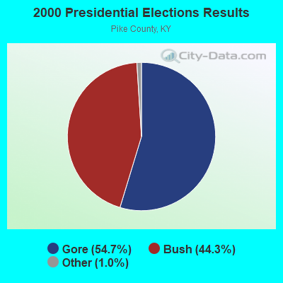


Graphs represent county-level data. Detailed 2008 Election Results
Religion statistics for Fedscreek, KY (based on Pike County data)
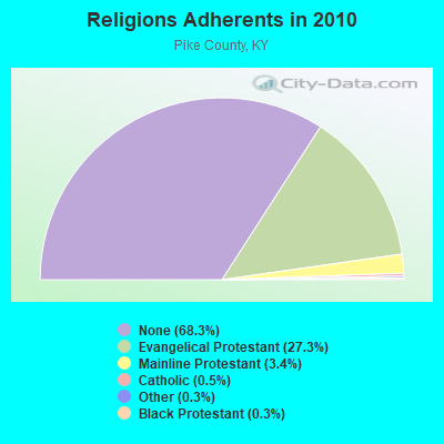
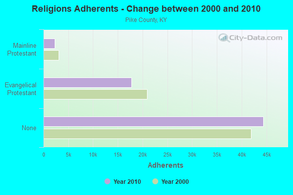
| Religion | Adherents | Congregations |
|---|---|---|
| Evangelical Protestant | 17,720 | 101 |
| Mainline Protestant | 2,227 | 15 |
| Catholic | 293 | 3 |
| Other | 213 | 3 |
| Black Protestant | 180 | 1 |
| None | 44,391 | - |
Food Environment Statistics:
| Here: | 3.51 / 10,000 pop. |
| Kentucky: | 2.19 / 10,000 pop. |
| Here: | 0.31 / 10,000 pop. |
| Kentucky: | 0.25 / 10,000 pop. |
| Pike County: | 0.31 / 10,000 pop. |
| State: | 0.74 / 10,000 pop. |
| This county: | 3.82 / 10,000 pop. |
| Kentucky: | 4.36 / 10,000 pop. |
| Here: | 4.12 / 10,000 pop. |
| State: | 5.74 / 10,000 pop. |
| Here: | 15.7% |
| Kentucky: | 11.0% |
| Pike County: | 33.3% |
| Kentucky: | 30.0% |
| Pike County: | 13.1% |
| Kentucky: | 15.9% |
Strongest AM radio stations in Fedscreek:
- WBPA (1460 AM; 5 kW; ELKHORN CITY, KY; Owner: EAST KENTUCKY BROADCASTING CORP)
- WNRG (940 AM; 5 kW; GRUNDY, VA; Owner: VIRGINIA-KENTUCKY BROADCASTING CO., INC)
- WLSI (900 AM; 5 kW; PIKEVILLE, KY; Owner: EAST KENTUCKY BROADCASTING CORPORATION)
- WDIC (1430 AM; daytime; 5 kW; CLINCHCO, VA; Owner: DICKENSON COUNTY BROADCASTING CORP.)
- WKYH (600 AM; 5 kW; PAINTSVILLE, KY; Owner: HIGHLANDS BROADCASTING CORPORATION)
- WYRV (770 AM; daytime; 5 kW; CEDAR BLUFF, VA; Owner: FAITH CHRISTIAN MUSIC BROADCASTING MINISTRIES, INC.)
- WPRT (960 AM; 5 kW; PRESTONSBURG, KY; Owner: EAST KENTUCKY RADIO NETWORK, INC.)
- WZAP (690 AM; 10 kW; BRISTOL, VA; Owner: RAM COMMUNICATIONS, INC.)
- WEZC (1480 AM; daytime; 5 kW; NEON, KY; Owner: JESUS COMMUNICATION ILNC.)
- WTCW (920 AM; 4 kW; WHITESBURG, KY; Owner: T.C.W. BROADCASTING , INC.)
- WGOC (640 AM; 10 kW; BLOUNTVILLE, TN; Owner: CITADEL BROADCASTING COMPANY)
- WPKE (1240 AM; 1 kW; PIKEVILLE, KY; Owner: EAST KENTUCKY BROADCASTING CORPORATION)
- WDOC (1310 AM; 5 kW; PRESTONSBURG, KY)
Strongest FM radio stations in Fedscreek:
- WPKE-FM (103.1 FM; COAL RUN, KY; Owner: EAST KENTUCKY BROADCASTING CORP.)
- WXLR (104.9 FM; HAROLD, KY; Owner: ADAM D GEARHEART)
- WDHR (93.1 FM; PIKEVILLE, KY; Owner: EAST KENTUCKY BROADCASTING CORP.)
- WVKM (106.7 FM; MATEWAN, WV; Owner: THREE STATES BROADCASTING CO., INC.)
- WMJD (97.7 FM; GRUNDY, VA; Owner: VIRGINIA-KENTUCKY BROADCASTING CO., INC.)
- WZLK (107.5 FM; VIRGIE, KY; Owner: EAST KENTUCKY BROADCASTING CORPORATION)
- WDXC (102.3 FM; POUND, VA; Owner: WDXC RADIO, INC.)
- WIFX-FM (94.3 FM; JENKINS, KY; Owner: LETCHER COUNTY BROADCASTING, INC)
- WXKQ-FM (103.9 FM; WHITESBURG, KY; Owner: T.C.W. BROADCASTING , INC.)
- WDIC-FM (92.1 FM; CLINCHCO, VA; Owner: DICKENSON COUNTY BROADCASTING CORP.)
- WMMT (88.7 FM; WHITESBURG, KY; Owner: APPALSHOP, INCORPORATED)
- WJSO (90.1 FM; PIKEVILLE, KY; Owner: THE MOODY BIBLE INSTITUTE OF CHICAGO)
- W251AI (98.1 FM; PIKEVILLE, KY; Owner: EAST KENTUCKY BROADCASTING CORPORATION)
- WXCC (96.5 FM; WILLIAMSON, WV; Owner: EAST KENTUCKY RADIO NETWORK, INC.)
- WAXM (93.5 FM; BIG STONE GAP, VA; Owner: VALLEY BROADCASTING, INC.)
- WSEH (102.7 FM; CUMBERLAND, KY; Owner: CUMBERLAND CITY BROADCASTING, INC.)
- WQHY (95.5 FM; PRESTONSBURG, KY; Owner: WDOC, INC.)
- W223AA (92.5 FM; BIG STONE GAP, VA; Owner: VALLEY BROADCASTING, INC.)
- WTFM (98.5 FM; KINGSPORT, TN; Owner: HOLSTON VALLEY BROADCASTING CORP.)
- WHCB (91.5 FM; BRISTOL, TN; Owner: APPALACHIAN EDUC. COMMUNICATION CORP)
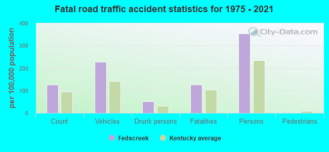
Fedscreek fatal accident list:
Oct 25, 2005 05:34 PM, Sr-1499, Lat: 37.508680, Lon: -82.077440, Vehicles: 1, Persons: 1, Fatalities: 1
Jan 23, 1999 05:58 PM, Sr-1499, Vehicles: 3, Persons: 7, Fatalities: 1, Drunk persons involved: 1
Aug 3, 1995 04:40 PM, 1499, Vehicles: 2, Persons: 2, Fatalities: 1
Dec 14, 1992 10:10 AM, 366, Vehicles: 1, Persons: 1, Fatalities: 1
FCC Registered Broadcast Land Mobile Towers:
1- Fedscreek Bps- 0.2mi W Of Fedscreek Rd & Laurel Fk Rd (Lat: 37.391389 Lon: -82.214444), Type: Upole, Structure height: 6.1 m, Call Sign: WPWL480,
Assigned Frequencies: 173.396 MHz, Grant Date: 09/25/2012, Expiration Date: 12/13/2022, Cancellation Date: 02/18/2023, Certifier: Moss Keesee, Registrant: Mountain Water District, 6332 Zebulon Hwy, Pikeville, KY 41502-3157, Phone: (606) 631-9162, Fax: (913) 390-4550, Email:
FCC Registered Amateur Radio Licenses:
1- Call Sign: AB4NG, Licensee ID: L01422136, Grant Date: 08/07/2008, Expiration Date: 11/05/2018, Cancellation Date: 11/06/2020, Certifier: Robert A Owens, Registrant: Robert A Owens, Rt 366 Box 120, Fedscreek, KY 41524
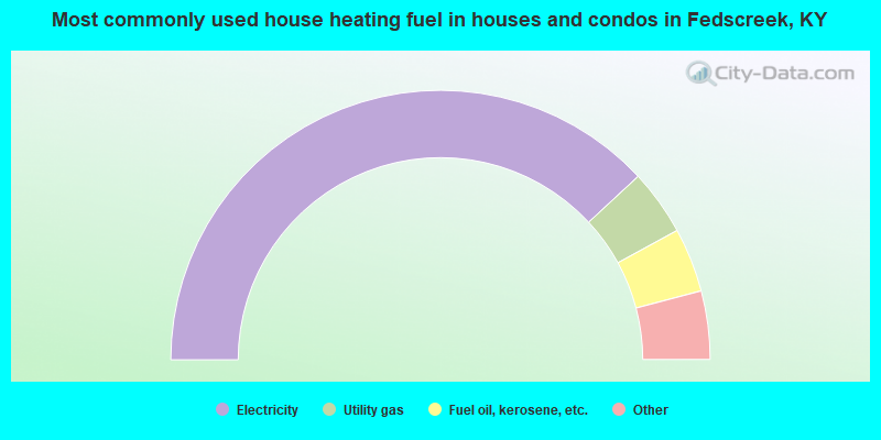
- 76.2%Electricity
- 7.9%Utility gas
- 7.7%Fuel oil, kerosene, etc.
- 3.9%Coal or coke
- 2.9%Bottled, tank, or LP gas
- 0.8%Wood
- 0.5%No fuel used
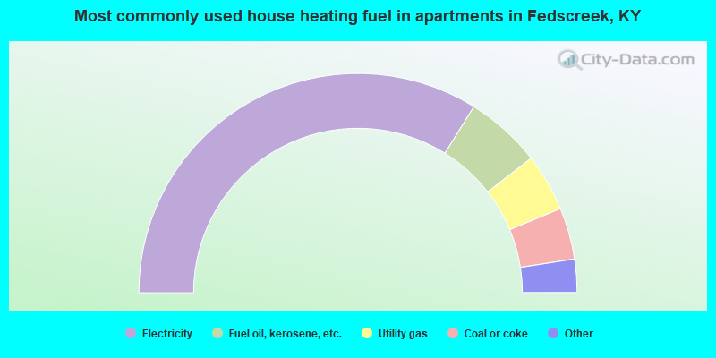
- 67.7%Electricity
- 11.2%Fuel oil, kerosene, etc.
- 8.5%Utility gas
- 7.6%Coal or coke
- 2.7%Bottled, tank, or LP gas
- 2.2%Wood
Fedscreek compared to Kentucky state average:
- Median household income below state average.
- Median house value below state average.
- Black race population percentage significantly below state average.
- Hispanic race population percentage significantly below state average.
- Median age below state average.
- Foreign-born population percentage significantly below state average.
- Renting percentage below state average.
- Length of stay since moving in significantly above state average.
- Number of rooms per house significantly below state average.
- House age significantly below state average.
- Percentage of population with a bachelor's degree or higher significantly below state average.