Farmington, Wisconsin
Submit your own pictures of this town and show them to the world
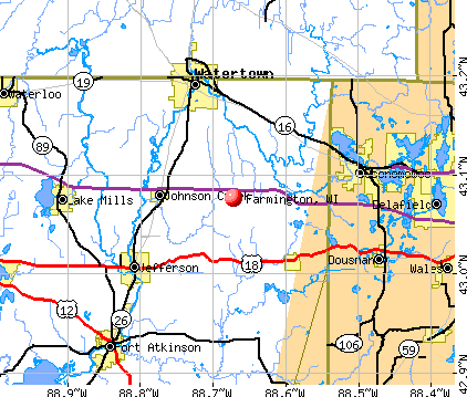
- OSM Map
- General Map
- Google Map
- MSN Map
Population change since 2000: -4.2%
| Males: 2,217 | |
| Females: 1,757 |
| Median resident age: | 51.4 years |
| Wisconsin median age: | 42.6 years |
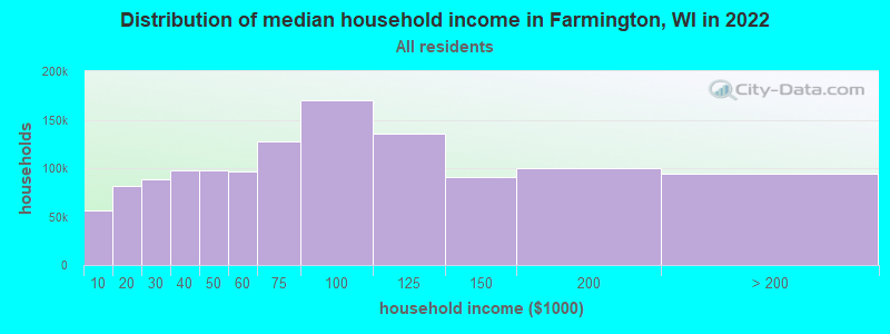
| Farmington: | $77,287 |
| WI: | $70,996 |
Estimated per capita income in 2022: $42,102 (it was $20,044 in 2000)
Farmington town income, earnings, and wages data
Estimated median house or condo value in 2022: $242,431 (it was $114,000 in 2000)
| Farmington: | $242,431 |
| WI: | $252,800 |
Mean prices in 2022: all housing units: $242,326; detached houses: $243,599; townhouses or other attached units: $213,855; in 2-unit structures: $165,520; in 3-to-4-unit structures: over $1,000,000; in 5-or-more-unit structures: $247,705; mobile homes: $177,749
Detailed information about poverty and poor residents in Farmington, WI
Compare current foreclosures near Farmington, WI:
| Photo | Address | Area | Beds / Baths | Price | Details |
|---|---|---|---|---|---|

|
#1
Mill St
Manawa, WI 54949
|
- sq. feet
|
- baths - beds |
$34,900
|
show details |

|
#2
Cemetery Rd
Weyauwega, WI 54983
|
- sq. feet
|
- baths 3 beds |
show details | |

|
#3
W Main St
Weyauwega, WI 54983
|
- sq. feet
|
2 baths 4 beds |
show details | |

|
#4
Mitchell Ave
Waupaca, WI 54981
|
- sq. feet
|
- baths - beds |
show details | |

|
#5
Golke Road
Waupaca, WI 54981
|
- sq. feet
|
- baths - beds |
show details | |

|
#6
Aspen Ave
Pine River, WI 54965
|
- sq. feet
|
- baths - beds |
show details | |

|
#7
County Road Ee
Redgranite, WI 54970
|
- sq. feet
|
- baths - beds |
show details | |

|
#8
County Rd E
Pine River, WI 54965
|
- sq. feet
|
- baths - beds |
show details | |

|
#9
County Road J
Almond, WI 54909
|
- sq. feet
|
- baths - beds |
show details | |

|
#10
Wells St
Manawa, WI 54949
|
- sq. feet
|
- baths - beds |
show details |
| Photo | Address | Area | Beds / Baths | Price | Details |
|---|---|---|---|---|---|

|
#11
Archer Ct
Pine River, WI 54965
|
- sq. feet
|
- baths - beds |
show details | |

|
#12
E Wilson Lake Rd
Wild Rose, WI 54984
|
- sq. feet
|
- baths - beds |
show details | |

|
#13
4th St
Almond, WI 54909
|
- sq. feet
|
- baths - beds |
show details | |

|
#14
E Alfred St
Weyauwega, WI 54983
|
- sq. feet
|
- baths - beds |
show details | |

|
#15
Cemetery Rd
Weyauwega, WI 54983
|
- sq. feet
|
- baths - beds |
show details | |

|
#16
Pine Tree Dr
Almond, WI 54909
|
- sq. feet
|
- baths - beds |
show details | |

|
#17
Bags Hill Rd
Waupaca, WI 54981
|
- sq. feet
|
- baths - beds |
show details | |

|
#18
Royalton St
Waupaca, WI 54981
|
- sq. feet
|
- baths - beds |
show details | |

|
#19
Oak St, Trlr 203
Waupaca, WI 54981
|
- sq. feet
|
- baths - beds |
show details | |

|
#20
Pineview Ln
Waupaca, WI 54981
|
- sq. feet
|
- baths - beds |
show details |
| Photo | Address | Area | Beds / Baths | Price | Details |
|---|---|---|---|---|---|

|
#21
W Main St # 3
Weyauwega, WI 54983
|
- sq. feet
|
- baths - beds |
show details | |

|
#22
S Grove St
Iola, WI 54945
|
- sq. feet
|
- baths - beds |
show details | |

|
#23
Main St
Wild Rose, WI 54984
|
- sq. feet
|
- baths - beds |
show details | |

|
#24
Division St
Iola, WI 54945
|
- sq. feet
|
- baths - beds |
show details | |

|
#25
Clark St
Manawa, WI 54949
|
- sq. feet
|
- baths - beds |
show details | |

|
#26
Sunset Lake Rd
Amherst Junction, WI 54407
|
- sq. feet
|
- baths - beds |
show details | |

|
#27
Washington St
Fremont, WI 54940
|
- sq. feet
|
- baths - beds |
show details | |

|
#28
County Rd W
Bancroft, WI 54921
|
- sq. feet
|
- baths - beds |
show details | |

|
Check over 1 million property listings on Foreclosure.com!
|
browse all offers | |||

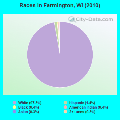
- 3,86597.3%White alone
- 551.4%Hispanic
- 170.4%Black alone
- 170.4%American Indian alone
- 100.3%Asian alone
- 100.3%Two or more races
Races in Farmington detailed stats: ancestries, foreign born residents, place of birth
 Recent articles from our blog. Our writers, many of them Ph.D. graduates or candidates, create easy-to-read articles on a wide variety of topics.

 | Seeking Advice For People Possibly Relocating To MKE Area (34 replies) |
| Wi men accused of running down deer w/snowmobiles (30 replies) |
| Texas to Iola, Wisconsin? (6 replies) |
| What's it like in Milwaukee? (34 replies) |
| Job offer in Brookfield (2 replies) |
| Question about Oshkosh (9 replies) |
Latest news from Farmington, WI collected exclusively by city-data.com from local newspapers, TV, and radio stations
Ancestries: German (38.4%), Irish (13.3%), Polish (10.6%), Norwegian (10.1%), English (8.7%), United States (6.1%).
Current Local Time: CST time zone
Elevation: 872 feet
Land area: 34.5 square miles.
Population density: 115 people per square mile (very low).
16 residents are foreign born
| This town: | 0.4% |
| Wisconsin: | 3.6% |
| Farmington town: | 1.7% ($1,890) |
| Wisconsin: | 2.0% ($2,245) |
Nearest city with pop. 50,000+: Oshkosh, WI  (38.1 miles , pop. 62,916).
Nearest city with pop. 200,000+: Madison, WI (89.6 miles , pop. 208,054).
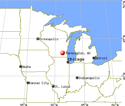
Nearest city with pop. 1,000,000+: Chicago, IL (189.6 miles , pop. 2,896,016).
Nearest cities:
), ), ), ), )Latitude: 44.36 N, Longitude: 89.16 W
Area code commonly used in this area: 715

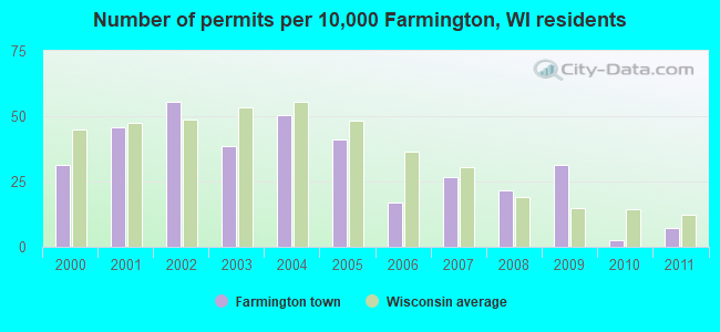
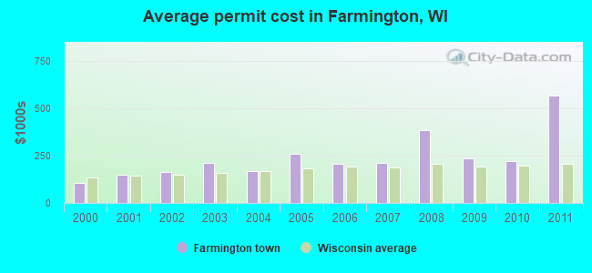
Single-family new house construction building permits:
- 2011: 3 buildings, average cost: $566,700
- 2010: 1 building, cost: $220,000
- 2009: 13 buildings, average cost: $233,400
- 2008: 9 buildings, average cost: $385,000
- 2007: 11 buildings, average cost: $211,400
- 2006: 7 buildings, average cost: $207,900
- 2005: 17 buildings, average cost: $260,300
- 2004: 21 buildings, average cost: $168,100
- 2003: 16 buildings, average cost: $209,100
- 2002: 23 buildings, average cost: $164,500
- 2001: 19 buildings, average cost: $148,200
- 2000: 13 buildings, average cost: $105,400
| Here: | 2.8% |
| Wisconsin: | 2.7% |
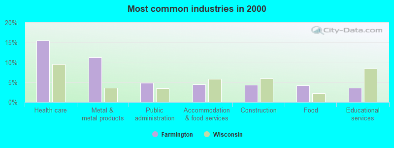
- Health care (15.5%)
- Metal & metal products (11.3%)
- Public administration (4.8%)
- Accommodation & food services (4.4%)
- Construction (4.4%)
- Food (4.3%)
- Educational services (3.6%)
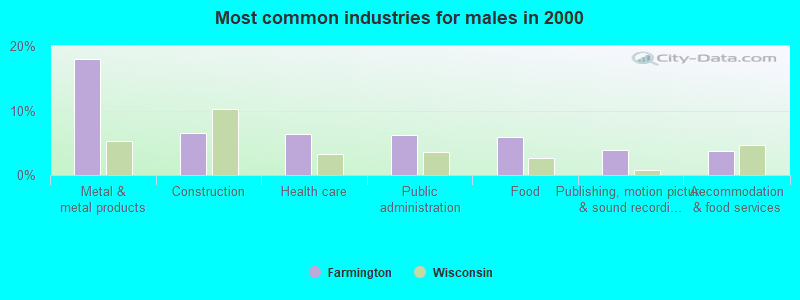
- Metal & metal products (17.9%)
- Construction (6.6%)
- Health care (6.4%)
- Public administration (6.2%)
- Food (5.9%)
- Publishing, motion picture & sound recording industries (3.8%)
- Accommodation & food services (3.7%)
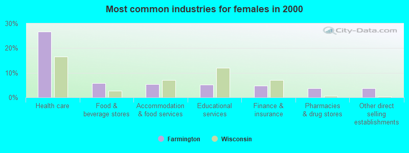
- Health care (26.7%)
- Food & beverage stores (5.7%)
- Accommodation & food services (5.3%)
- Educational services (5.2%)
- Finance & insurance (4.8%)
- Pharmacies & drug stores (3.8%)
- Other direct selling establishments (3.8%)
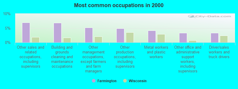
- Other sales and related occupations, including supervisors (6.9%)
- Building and grounds cleaning and maintenance occupations (6.8%)
- Other management occupations, except farmers and farm managers (5.1%)
- Other production occupations, including supervisors (4.8%)
- Metal workers and plastic workers (4.1%)
- Other office and administrative support workers, including supervisors (3.3%)
- Driver/sales workers and truck drivers (3.3%)
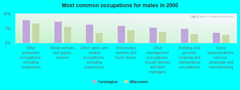
- Other production occupations, including supervisors (8.0%)
- Metal workers and plastic workers (7.4%)
- Other sales and related occupations, including supervisors (6.4%)
- Driver/sales workers and truck drivers (5.9%)
- Other management occupations, except farmers and farm managers (5.4%)
- Building and grounds cleaning and maintenance occupations (5.0%)
- Sales representatives, services, wholesale and manufacturing (3.6%)
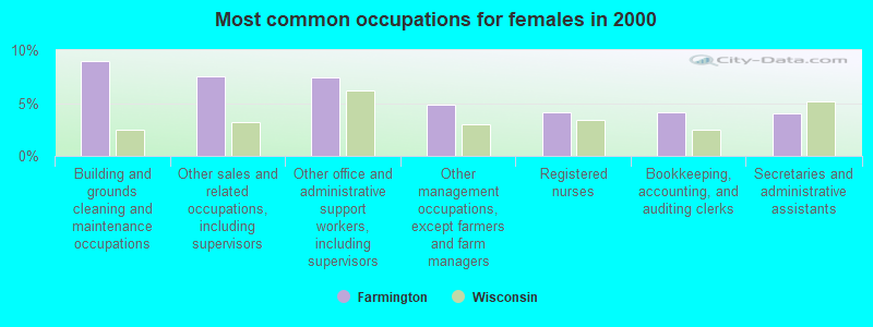
- Building and grounds cleaning and maintenance occupations (9.0%)
- Other sales and related occupations, including supervisors (7.6%)
- Other office and administrative support workers, including supervisors (7.4%)
- Other management occupations, except farmers and farm managers (4.8%)
- Registered nurses (4.2%)
- Bookkeeping, accounting, and auditing clerks (4.2%)
- Secretaries and administrative assistants (4.0%)
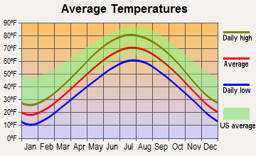
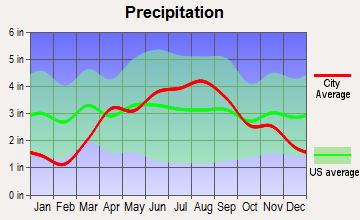
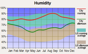
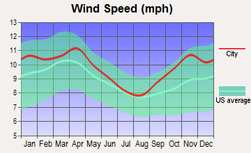
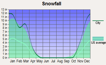
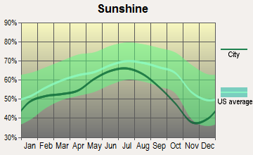
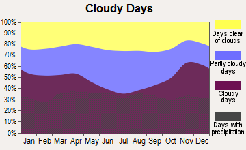
Average climate in Farmington, Wisconsin
Based on data reported by over 4,000 weather stations
Tornado activity:
Farmington-area historical tornado activity is slightly above Wisconsin state average. It is 34% greater than the overall U.S. average.
On 9/26/1951, a category F4 (max. wind speeds 207-260 mph) tornado 7.1 miles away from the Farmington town center killed 6 people and injured 3 people and caused between $50,000 and $500,000 in damages.
On 4/27/1984, a category F4 tornado 28.1 miles away from the town center killed one person and injured 19 people and caused between $500,000 and $5,000,000 in damages.
Earthquake activity:
Farmington-area historical earthquake activity is significantly above Wisconsin state average. It is 3% smaller than the overall U.S. average.On 6/28/2004 at 06:10:52, a magnitude 4.2 (4.2 MW, Depth: 6.2 mi, Class: Light, Intensity: IV - V) earthquake occurred 201.0 miles away from Farmington center
On 4/18/2008 at 09:36:59, a magnitude 5.4 (5.1 MB, 4.8 MS, 5.4 MW, 5.2 MW, Class: Moderate, Intensity: VI - VII) earthquake occurred 413.9 miles away from Farmington center
On 6/10/1987 at 23:48:54, a magnitude 5.1 (4.9 MB, 4.4 MS, 4.6 MS, 5.1 LG) earthquake occurred 388.7 miles away from Farmington center
On 5/2/2015 at 16:23:07, a magnitude 4.2 (4.2 MW, Depth: 2.8 mi) earthquake occurred 238.5 miles away from the city center
On 2/10/2010 at 09:59:35, a magnitude 3.8 (3.8 MW, Depth: 6.2 mi, Class: Light, Intensity: II - III) earthquake occurred 168.7 miles away from Farmington center
On 4/18/2008 at 09:36:59, a magnitude 5.2 (5.2 MW, Depth: 8.9 mi) earthquake occurred 413.9 miles away from the city center
Magnitude types: regional Lg-wave magnitude (LG), body-wave magnitude (MB), surface-wave magnitude (MS), moment magnitude (MW)
Natural disasters:
The number of natural disasters in Waupaca County (9) is smaller than the US average (15).Major Disasters (Presidential) Declared: 6
Emergencies Declared: 2
Causes of natural disasters: Floods: 6, Storms: 5, Tornadoes: 3, Drought: 1, Hurricane: 1, Wind: 1, Other: 1 (Note: some incidents may be assigned to more than one category).
Hospitals and medical centers near Farmington:
- DAVITA - GRAND SEASONS DIALYSIS (Dialysis Facility, about 3 miles away; WAUPACA, WI)
- FMC DIALYSIS - WAUPACA (Dialysis Facility, about 3 miles away; WAUPACA, WI)
- CRYSTAL RIVER NUR REHAB (Nursing Home, about 4 miles away; WAUPACA, WI)
- RECOVER HEALTH OF WISCONSIN INC (Home Health Center, about 5 miles away; WAUPACA, WI)
- RIVERSIDE MEDICAL CENTER, INC Critical Access Hospitals (about 5 miles away; WAUPACA, WI)
- HOSPICE PGM WAUPACA CTY (Hospital, about 5 miles away; WAUPACA, WI)
- BETHANY HOME (Nursing Home, about 7 miles away; WAUPACA, WI)
Colleges/universities with over 2000 students nearest to Farmington:
- University of Wisconsin-Stevens Point (about 24 miles; Stevens Point, WI; Full-time enrollment: 9,089)
- Mid-State Technical College (about 31 miles; Wisconsin Rapids, WI; FT enrollment: 2,128)
- Fox Valley Technical College (about 36 miles; Appleton, WI; FT enrollment: 5,682)
- University of Wisconsin-Oshkosh (about 39 miles; Oshkosh, WI; FT enrollment: 10,637)
- Lawrence University (about 39 miles; Appleton, WI; FT enrollment: 2,821)
- Northcentral Technical College (about 50 miles; Wausau, WI; FT enrollment: 3,356)
- Northeast Wisconsin Technical College (about 54 miles; Green Bay, WI; FT enrollment: 6,069)
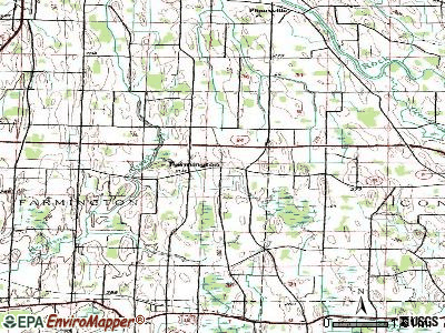
Points of interest:
Notable locations in Farmington: Edmunds Dock (A), Camp Onaway (B), King Fire Department - Wisconsin Veterans Home (C), Loyola Villa (D). Display/hide their locations on the map
Churches in Farmington include: Farmington Church (A), Shepherd of the Lakes Lutheran Church (B). Display/hide their locations on the map
Cemeteries: Farmington Lutheran Cemetery (1), Salem Cemetery (2), Wisconsin Veterans Memorial Cemetery (3). Display/hide their locations on the map
Lakes: Mud Lake (A), Old Taylor Lake (B), Otter Lake (C), Ottman Lake (D), Rainbow Lake (E), Lake Nymphaea (F), Nessling Lake (G), Limekiln Lake (H). Display/hide their locations on the map
| This town: | 2.4 people |
| Wisconsin: | 2.4 people |
| This town: | 72.6% |
| Whole state: | 64.4% |
| This town: | 5.6% |
| Whole state: | 7.3% |
Likely homosexual households (counted as self-reported same-sex unmarried-partner households)
- Lesbian couples: 0.1% of all households
- Gay men: 0.1% of all households
| This town: | 8.1% |
| Whole state: | 8.7% |
| This town: | 2.5% |
| Whole state: | 3.7% |
People in group quarters in Farmington in 2010:
- 675 people in nursing facilities/skilled-nursing facilities
- 28 people in residential treatment centers for juveniles (non-correctional)
- 26 people in emergency and transitional shelters (with sleeping facilities) for people experiencing homelessness
- 3 people in group homes intended for adults
14 people in other nonhousehold living situations in 2000
For population 15 years and over in Farmington:
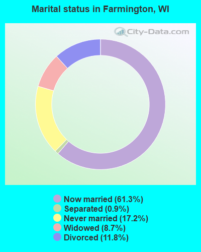
- Never married: 17.2%
- Now married: 61.3%
- Separated: 0.9%
- Widowed: 8.7%
- Divorced: 11.8%
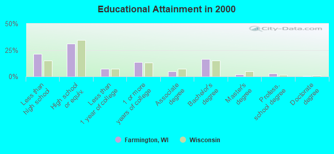
For population 25 years and over in Farmington:
- High school or higher: 78.5%
- Bachelor's degree or higher: 22.3%
- Graduate or professional degree: 5.7%
- Unemployed: 4.3%
- Mean travel time to work (commute): 19.8 minutes
| Here: | 11.7 |
| Wisconsin average: | 11.0 |
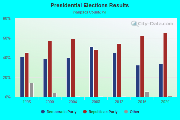
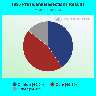
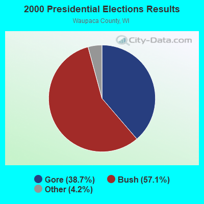


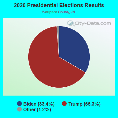
Graphs represent county-level data. Detailed 2008 Election Results
Religion statistics for Farmington, WI (based on Waupaca County data)
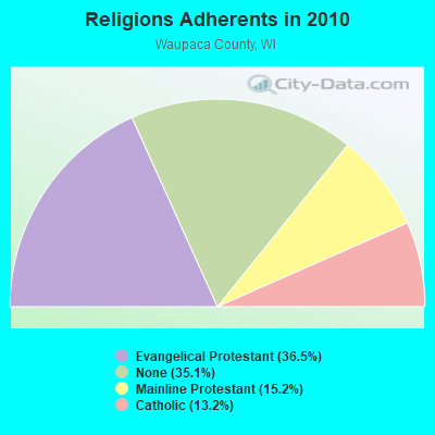
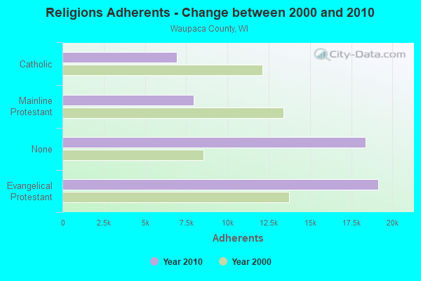
| Religion | Adherents | Congregations |
|---|---|---|
| Evangelical Protestant | 19,152 | 62 |
| Mainline Protestant | 7,941 | 18 |
| Catholic | 6,932 | 7 |
| Other | 9 | 3 |
| None | 18,376 | - |
Food Environment Statistics:
| Waupaca County: | 1.93 / 10,000 pop. |
| Wisconsin: | 1.86 / 10,000 pop. |
| Here: | 6.35 / 10,000 pop. |
| State: | 4.12 / 10,000 pop. |
| This county: | 9.63 / 10,000 pop. |
| State: | 8.64 / 10,000 pop. |
| Waupaca County: | 7.9% |
| State: | 7.6% |
| Here: | 27.6% |
| Wisconsin: | 27.5% |
| Waupaca County: | 11.4% |
| State: | 13.0% |
Strongest AM radio stations in Farmington:
- WDUX (800 AM; 5 kW; WAUPACA, WI; Owner: LAIRD BROADCASTING COMPANY, INC.)
- WSPT (1010 AM; 50 kW; STEVENS POINT, WI)
- WNAM (1280 AM; 50 kW; NEENAH-MENASHA, WI; Owner: CUMULUS LICENSING CORP.)
- WSAU (550 AM; 20 kW; WAUSAU, WI; Owner: WRIG, INC.)
- WHBY (1150 AM; 25 kW; KIMBERLY, WI; Owner: WOODWARD COMMUNICATIONS, INC.)
- WTMJ (620 AM; 50 kW; MILWAUKEE, WI; Owner: JOURNAL BROADCAST CORPORATION)
- WFCL (1380 AM; 4 kW; CLINTONVILLE, WI; Owner: RESULTS BROADCASTING CORP.)
- WRIG (1390 AM; 10 kW; SCHOFIELD, WI; Owner: WRIG, INC.)
- WFHR (1320 AM; 5 kW; WISCONSIN RAPIDS, WI; Owner: WISCONSIN RAPIDS BROADCASTING, LLC)
- WISN (1130 AM; 50 kW; MILWAUKEE, WI; Owner: CAPSTAR TX LIMITED PARTNERSHIP)
- WTAQ (1360 AM; 10 kW; GREEN BAY, WI; Owner: MIDWEST COMMUNICATIONS, INC.)
- WLBL (930 AM; 5 kW; AUBURNDALE, WI; Owner: STATE OF WISCONSIN - EDUCATIONAL COMMUNICATIONS BOARD)
- WSCR (670 AM; 50 kW; CHICAGO, IL; Owner: INFINITY BROADCASTING OPERATIONS, INC.)
Strongest FM radio stations in Farmington:
- WDUX-FM (92.7 FM; WAUPACA, WI; Owner: LAIRD BROADCASTING COMPANY, INC.)
- WAPL-FM (105.7 FM; APPLETON, WI; Owner: WOODWARD COMMUNICATIONS, INC.)
- WGLX-FM (103.3 FM; WISCONSIN RAPIDS, WI; Owner: WISCONSIN RAPIDS BROADCASTING, LLC)
- WHRM (90.9 FM; WAUSAU, WI; Owner: STATE OF WISCONSIN - EDUCATIONAL COMMUNICATIONS BOARD)
- WIZD (99.9 FM; RUDOLPH, WI; Owner: WRIG, INC)
- WAUH (102.3 FM; WAUTOMA, WI; Owner: HOMETOWN BROADCASTING LLC)
- WLJY (106.5 FM; MARSHFIELD, WI; Owner: NEWRADIO GROUP, LLC)
- WYTE (96.7 FM; WHITING, WI; Owner: NEWRADIO GROUP, LLC)
- WBJZ (104.7 FM; BERLIN, WI; Owner: CAXAMBAS CORPORATION)
- WSPT-FM (97.9 FM; STEVENS POINT, WI; Owner: AMERICUS COMMUNICATIONS, LLC)
- WWSP (89.9 FM; STEVENS POINT, WI; Owner: BD. OF REGENTS OF UNIV. OF WISCONSIN)
TV broadcast stations around Farmington:
- W66DC (Channel 66; WAUPACA, WI; Owner: TRINITY BROADCASTING NETWORK)
- W24BV (Channel 24; WHITING, WI; Owner: MS COMMUNICATIONS, LLC)
- W60CI (Channel 60; WHITING, WI; Owner: MS COMMUNICATIONS, LLC)
- WMMF-TV (Channel 68; FOND DU LAC, WI; Owner: PAPPAS TELECASTING OF WISCONSIN, A CALIFORNIA LTD PARTNRSHP)
- W16AY (Channel 16; WHITING, WI; Owner: MS COMMUNICATIONS, LLC)
- W18CS (Channel 18; WHITING, WI; Owner: MS COMMUNICATIONS, LLC)
- W40BC (Channel 40; WHITING, WI; Owner: MS COMMUNICATIONS, LLC)
- W62DA (Channel 62; WHITING, WI; Owner: MS COMMUNICATIONS, LLC)
- National Bridge Inventory (NBI) Statistics
- 15Number of bridges
- 157ft / 47.6mTotal length
- $1,869,000Total costs
- 106,122Total average daily traffic
- 5,901Total average daily truck traffic
- New bridges - historical statistics
- 11950-1959
- 41960-1969
- 11980-1989
- 41990-1999
- 42000-2009
- 12010-2019
FCC Registered Antenna Towers:
2- Peter M Connolly, Near W3477 Ranch Road (Lat: 43.090250 Lon: -88.702306), Type: 60.9, Overall height: 56.3 m, Registrant: Holland & Knight LLP, Pconnoll@hklaw.Com, , Washi-ngton, Phone: (202) 862-5989
- Peter M Connolly, Near W3477 Ranch Road (Lat: 43.090250 Lon: -88.702306), Type: 60.9, Overall height: 56.3 m, Registrant: United States Cellular Corporation, Stephanie.Terrell@uscellular.Com, , Chica-go, Phone: (773) 399-8900
FCC Registered Broadcast Land Mobile Towers:
2- 120 Ne Of Int Cty Hwy B & Farmington (Lat: 43.075833 Lon: -88.670944), Call Sign: KNDV870, Licensee ID: L00644633,
Assigned Frequencies: 155.925 MHz, Grant Date: 02/28/2003, Expiration Date: 04/15/2013, Cancellation Date: 06/15/2013, Registrant: Farmington, Town Of, W3157 Bakertown Rd, Helenville, WI 53137-9743, Phone: (920) 699-2348, Fax: (920) 699-5027
- BOYS & GIRLS BRIGADE, E1703 Pine Ridge Lane (Lat: 44.344944 Lon: -89.150528), Type: Building, Structure height: 9 m, Call Sign: WRDQ777,
Assigned Frequencies: 462.875 MHz, Grant Date: 06/28/2019, Expiration Date: 06/28/2029, Certifier: Laura Kemps, Registrant: Visiplex, Inc., 1287 North Barclay Boulevard, Buffalo Grove, IL 60089, Phone: (847) 229-0250, Fax: (847) 229-0259, Email:
FCC Registered Microwave Towers:
1- Johnson Creek, Off Y Road (Lat: 43.064667 Lon: -88.773333), Type: Ltower, Structure height: 59.4 m, Call Sign: WRVN680,
Assigned Frequencies: 11345.0 MHz, 11465.0 MHz, 11345.0 MHz, 11465.0 MHz, 11345.0 MHz, 11465.0 MHz, 11345.0 MHz, 11465.0 MHz, Grant Date: 12/14/2022, Expiration Date: 12/14/2032, Certifier: Todd Lindert, Registrant: Micronet Communications, Inc., 812 Lexington Dr, Plano, TX 75075, Phone: (972) 422-7200, Email:
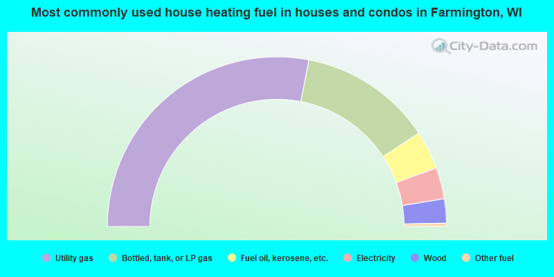
- 56.0%Utility gas
- 25.4%Bottled, tank, or LP gas
- 7.3%Fuel oil, kerosene, etc.
- 6.0%Electricity
- 4.6%Wood
- 0.6%Other fuel
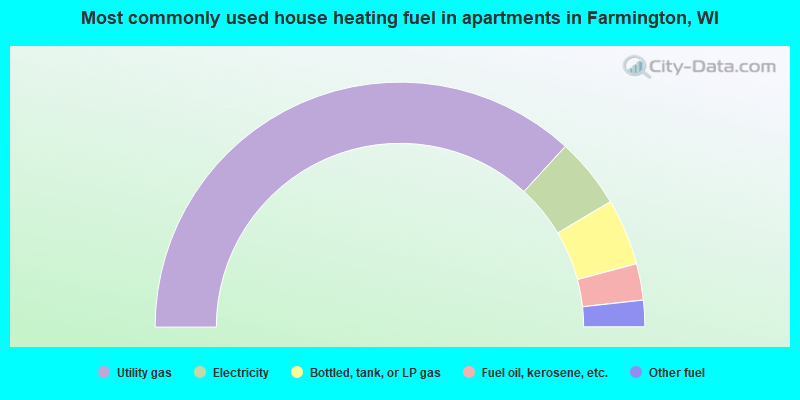
- 73.6%Utility gas
- 9.3%Electricity
- 8.8%Bottled, tank, or LP gas
- 4.8%Fuel oil, kerosene, etc.
- 3.5%Other fuel
Farmington compared to Wisconsin state average:
- Unemployed percentage significantly below state average.
- Black race population percentage significantly below state average.
- Hispanic race population percentage significantly below state average.
- Median age significantly above state average.
- Foreign-born population percentage significantly below state average.
- Renting percentage below state average.
- Length of stay since moving in significantly above state average.
- Number of rooms per house significantly below state average.
- House age significantly below state average.
- Institutionalized population percentage significantly above state average.
- Number of college students significantly below state average.
Farmington on our top lists:
- #9 on the list of "Top 101 cities with the largest percentage of people in nursing homes (population 1,000+)"
- #12 on the list of "Top 101 counties with the highest number of deaths per 1000 residents 2007-2013 (pop. 50,000+)"
- #77 on the list of "Top 101 counties with the largest number of people without health insurance coverage in 2000 (pop. 50,000+)"