Erin, Wisconsin
Submit your own pictures of this town and show them to the world
- OSM Map
- Google Map
- MSN Map
Population change since 2000: +2.3%
 |
| Males: 1,880 | |
| Females: 1,867 |
| Median resident age: | 46.8 years |
| Wisconsin median age: | 42.6 years |
Zip codes: 53027.
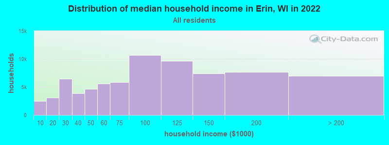
| Erin: | $116,589 |
| WI: | $70,996 |
Estimated per capita income in 2022: $52,674 (it was $28,851 in 2000)
Erin town income, earnings, and wages data
Estimated median house or condo value in 2022: $442,012 (it was $214,900 in 2000)
| Erin: | $442,012 |
| WI: | $252,800 |
Mean prices in 2022: all housing units: $365,194; detached houses: $394,485; townhouses or other attached units: $248,976; in 2-unit structures: $202,569; in 3-to-4-unit structures: $190,719; in 5-or-more-unit structures: $169,378; mobile homes: $84,115
Detailed information about poverty and poor residents in Erin, WI


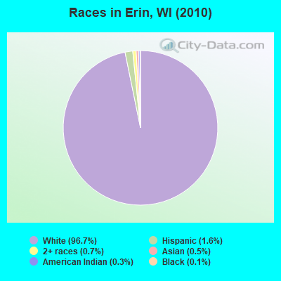
- 3,62596.7%White alone
- 601.6%Hispanic
- 270.7%Two or more races
- 170.5%Asian alone
- 110.3%American Indian alone
- 50.1%Black alone
- 20.05%Native Hawaiian and Other
Pacific Islander alone
Races in Erin detailed stats: ancestries, foreign born residents, place of birth
 Recent articles from our blog. Our writers, many of them Ph.D. graduates or candidates, create easy-to-read articles on a wide variety of topics.
Ancestries: German (55.5%), Irish (19.2%), Polish (10.4%), Italian (8.1%), English (6.6%), French (4.5%).
Current Local Time: CST time zone
Land area: 35.9 square miles.
Population density: 104 people per square mile (very low).
136 residents are foreign born (2.2% Europe, 0.7% Latin America, 0.5% Asia).
| This town: | 3.7% |
| Wisconsin: | 3.6% |
| Erin town: | 1.6% ($3,545) |
| Wisconsin: | 2.0% ($2,245) |
Nearest city with pop. 50,000+: Waukesha, WI  (16.8 miles , pop. 64,825).
Nearest city with pop. 200,000+: Milwaukee, WI (23.8 miles , pop. 596,974).
Nearest city with pop. 1,000,000+: Chicago, IL (102.6 miles , pop. 2,896,016).
Nearest cities:
), ), ), )Latitude: 43.24 N, Longitude: 88.35 W
Area code commonly used in this area: 262
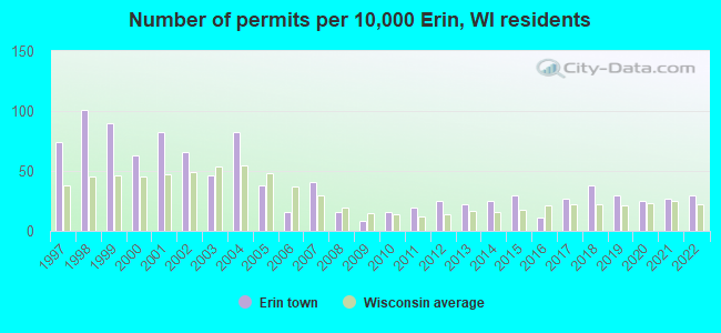
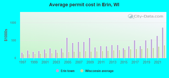
Single-family new house construction building permits:
- 2022: 11 buildings, average cost: $869,300
- 2021: 10 buildings, average cost: $630,500
- 2020: 9 buildings, average cost: $534,600
- 2019: 11 buildings, average cost: $508,700
- 2018: 14 buildings, average cost: $347,700
- 2017: 10 buildings, average cost: $506,400
- 2016: 4 buildings, average cost: $336,800
- 2015: 11 buildings, average cost: $287,800
- 2014: 9 buildings, average cost: $378,300
- 2013: 8 buildings, average cost: $378,300
- 2012: 9 buildings, average cost: $337,600
- 2011: 7 buildings, average cost: $346,000
- 2010: 6 buildings, average cost: $308,300
- 2009: 3 buildings, average cost: $572,000
- 2008: 6 buildings, average cost: $462,600
- 2007: 15 buildings, average cost: $462,600
- 2006: 6 buildings, average cost: $432,100
- 2005: 14 buildings, average cost: $581,400
- 2004: 30 buildings, average cost: $277,700
- 2003: 17 buildings, average cost: $240,500
- 2002: 24 buildings, average cost: $281,500
- 2001: 30 buildings, average cost: $251,600
- 2000: 23 buildings, average cost: $204,300
- 1999: 33 buildings, average cost: $184,000
- 1998: 37 buildings, average cost: $217,700
- 1997: 27 buildings, average cost: $165,100
| Here: | 2.2% |
| Wisconsin: | 2.7% |
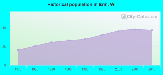
Population change in the 1990s: +866 (+31.0%).
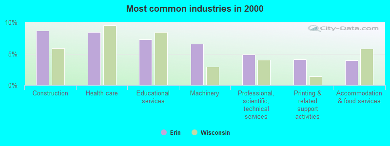
- Construction (8.7%)
- Health care (8.5%)
- Educational services (7.3%)
- Machinery (6.6%)
- Professional, scientific, technical services (4.9%)
- Printing & related support activities (4.1%)
- Accommodation & food services (3.9%)
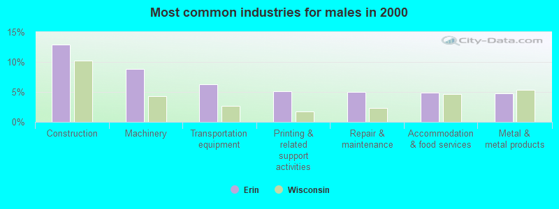
- Construction (12.9%)
- Machinery (8.8%)
- Transportation equipment (6.3%)
- Printing & related support activities (5.1%)
- Repair & maintenance (5.0%)
- Accommodation & food services (4.8%)
- Metal & metal products (4.8%)
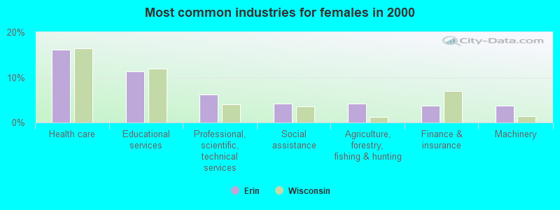
- Health care (16.2%)
- Educational services (11.3%)
- Professional, scientific, technical services (6.2%)
- Social assistance (4.2%)
- Agriculture, forestry, fishing & hunting (4.1%)
- Finance & insurance (3.8%)
- Machinery (3.7%)
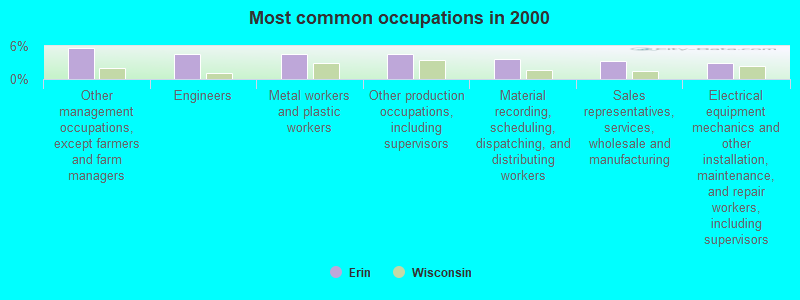
- Other management occupations, except farmers and farm managers (5.6%)
- Engineers (4.6%)
- Metal workers and plastic workers (4.5%)
- Other production occupations, including supervisors (4.5%)
- Material recording, scheduling, dispatching, and distributing workers (3.7%)
- Sales representatives, services, wholesale and manufacturing (3.2%)
- Electrical equipment mechanics and other installation, maintenance, and repair workers, including supervisors (3.0%)
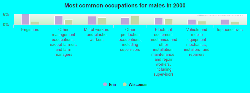
- Engineers (8.0%)
- Other management occupations, except farmers and farm managers (7.1%)
- Metal workers and plastic workers (6.6%)
- Other production occupations, including supervisors (5.6%)
- Electrical equipment mechanics and other installation, maintenance, and repair workers, including supervisors (5.2%)
- Vehicle and mobile equipment mechanics, installers, and repairers (4.1%)
- Top executives (4.1%)

- Registered nurses (5.2%)
- Bookkeeping, accounting, and auditing clerks (5.2%)
- Other office and administrative support workers, including supervisors (5.0%)
- Preschool, kindergarten, elementary, and middle school teachers (4.8%)
- Counselors, social workers, and other community and social service specialists (4.4%)
- Health technologists and technicians (4.1%)
- Secretaries and administrative assistants (4.1%)
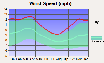
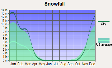
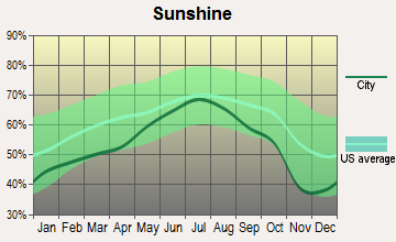
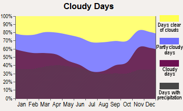
Average climate in Erin, Wisconsin
Based on data reported by over 4,000 weather stations


(lower is better)
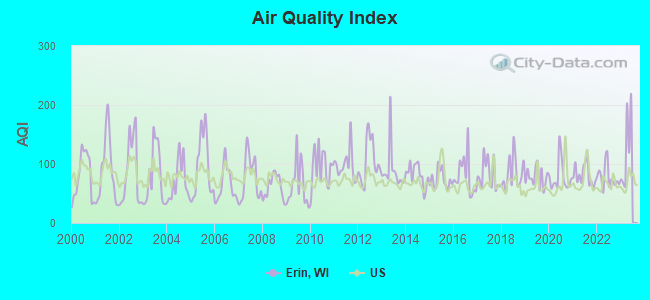
Air Quality Index (AQI) level in 2022 was 77.9. This is about average.
| City: | 77.9 |
| U.S.: | 72.6 |
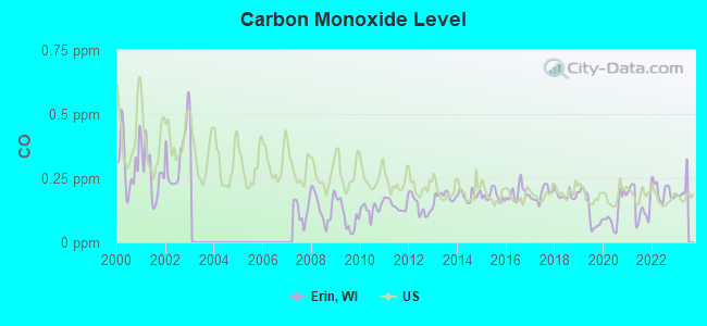
Carbon Monoxide (CO) [ppm] level in 2022 was 0.198. This is better than average. Closest monitor was 16.2 miles away from the city center.
| City: | 0.198 |
| U.S.: | 0.251 |
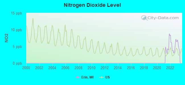
Nitrogen Dioxide (NO2) [ppb] level in 2022 was 5.20. This is about average. Closest monitor was 20.2 miles away from the city center.
| City: | 5.20 |
| U.S.: | 5.11 |
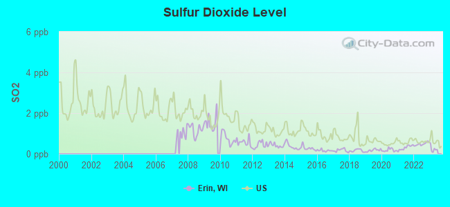
Sulfur Dioxide (SO2) [ppb] level in 2022 was 0.483. This is significantly better than average. Closest monitor was 16.2 miles away from the city center.
| City: | 0.483 |
| U.S.: | 1.515 |
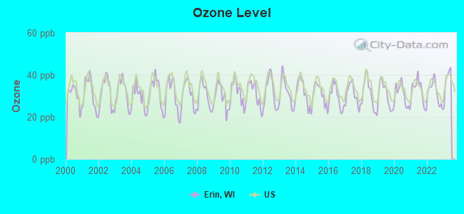
Ozone [ppb] level in 2022 was 31.5. This is about average. Closest monitor was 7.4 miles away from the city center.
| City: | 31.5 |
| U.S.: | 33.3 |
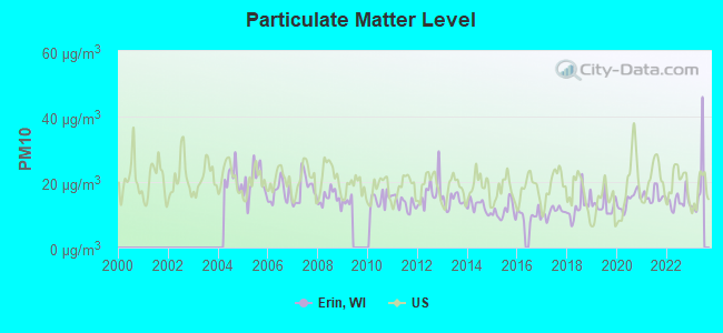
Particulate Matter (PM10) [µg/m3] level in 2022 was 14.1. This is better than average. Closest monitor was 5.8 miles away from the city center.
| City: | 14.1 |
| U.S.: | 19.2 |
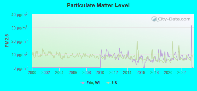
Particulate Matter (PM2.5) [µg/m3] level in 2022 was 7.50. This is about average. Closest monitor was 16.2 miles away from the city center.
| City: | 7.50 |
| U.S.: | 8.11 |
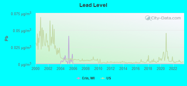
Lead (Pb) [µg/m3] level in 2005 was 0.0105. This is about average. Closest monitor was 16.2 miles away from the city center.
| City: | 0.0105 |
| U.S.: | 0.0093 |
Tornado activity:
Erin-area historical tornado activity is slightly above Wisconsin state average. It is 47% greater than the overall U.S. average.
On 4/27/1984, a category F4 (max. wind speeds 207-260 mph) tornado 13.4 miles away from the Erin town center killed one person and injured 14 people and caused between $500,000 and $5,000,000 in damages.
On 7/18/1996, a category F5 (max. wind speeds 261-318 mph) tornado 33.4 miles away from the town center injured 12 people and caused $40 million in damages.
Earthquake activity:
Erin-area historical earthquake activity is significantly above Wisconsin state average. It is 12% greater than the overall U.S. average.On 4/18/2008 at 09:36:59, a magnitude 5.4 (5.1 MB, 4.8 MS, 5.4 MW, 5.2 MW, Class: Moderate, Intensity: VI - VII) earthquake occurred 331.9 miles away from Erin center
On 6/28/2004 at 06:10:52, a magnitude 4.2 (4.2 MW, Depth: 6.2 mi, Class: Light, Intensity: IV - V) earthquake occurred 126.1 miles away from Erin center
On 6/10/1987 at 23:48:54, a magnitude 5.1 (4.9 MB, 4.4 MS, 4.6 MS, 5.1 LG) earthquake occurred 306.5 miles away from Erin center
On 4/18/2008 at 09:36:59, a magnitude 5.2 (5.2 MW, Depth: 8.9 mi) earthquake occurred 332.0 miles away from Erin center
On 5/2/2015 at 16:23:07, a magnitude 4.2 (4.2 MW, Depth: 2.8 mi) earthquake occurred 163.9 miles away from the city center
On 2/10/2010 at 09:59:35, a magnitude 3.8 (3.8 MW, Depth: 6.2 mi, Class: Light, Intensity: II - III) earthquake occurred 88.1 miles away from the city center
Magnitude types: regional Lg-wave magnitude (LG), body-wave magnitude (MB), surface-wave magnitude (MS), moment magnitude (MW)
Natural disasters:
The number of natural disasters in Washington County (11) is smaller than the US average (15).Major Disasters (Presidential) Declared: 8
Emergencies Declared: 3
Causes of natural disasters: Storms: 6, Floods: 5, Drought: 1, Hurricane: 1, Snow: 1, Snowstorm: 1, Tornado: 1, Wind: 1, Winter Storm: 1, Other: 1 (Note: some incidents may be assigned to more than one category).
Hospitals and medical centers near Erin:
- HARDFORD CARE CENTER (Nursing Home, about 6 miles away; HARTFORD, WI)
- HARTFORD HLTHCARE CTR (Nursing Home, about 6 miles away; HARTFORD, WI)
- BRIDGES HOME HEALTHCARE (Home Health Center, about 6 miles away; HARTFORD, WI)
- AURORA MED CENTER WASHINGTON COUNTY Acute Care Hospitals (about 6 miles away; HARTFORD, WI)
- KETTLE MORAINE HOSPITAL (Hospital, about 11 miles away; OCONOMOWOC, WI)
- PROHEALTH HOME CARE (Home Health Center, about 11 miles away; HARTLAND, WI)
- ROLLAND NELSON CROSSROADS HSPC (Hospital, about 11 miles away; HARTLAND, WI)
Colleges/universities with over 2000 students nearest to Erin:
- Waukesha County Technical College (about 13 miles; Pewaukee, WI; Full-time enrollment: 4,415)
- Carroll University (about 18 miles; Waukesha, WI; FT enrollment: 3,313)
- Concordia University-Wisconsin (about 23 miles; Mequon, WI; FT enrollment: 5,253)
- Cardinal Stritch University (about 24 miles; Milwaukee, WI; FT enrollment: 3,595)
- Marquette University (about 26 miles; Milwaukee, WI; FT enrollment: 9,844)
- Milwaukee Area Technical College (about 26 miles; Milwaukee, WI; FT enrollment: 13,156)
- Milwaukee School of Engineering (about 27 miles; Milwaukee, WI; FT enrollment: 2,386)
Points of interest:
Notable locations in Erin: Monches Farm (A), Culleden Farm (B), Ehmke Farms (C), Hill View Farms (D), Kettle Hills Farm (E), Log House Farm (F), Murphy Lake Farms (G), Rubicon River Farm (H), Stone Ridge Farms (I), Twilight Farms (J), Roskopf Farms (K), Stapleton Farms (L). Display/hide their locations on the map
Church in Erin: Emmanuel Church (A). Display/hide its location on the map
Cemetery: Saint Johns Cemetery (1). Display/hide its location on the map
Lakes and reservoirs: Murphy Lake (A), Beck Lake (B), Hickey Lake (C), Lowes Lake (D), Malloy Lake (E), McConville Lake (F), Druid Lake (G). Display/hide their locations on the map
Creek: Flynn Creek (A). Display/hide its location on the map
| This town: | 2.7 people |
| Wisconsin: | 2.4 people |
| This town: | 82.3% |
| Whole state: | 64.4% |
| This town: | 3.3% |
| Whole state: | 7.3% |
Likely homosexual households (counted as self-reported same-sex unmarried-partner households)
- Lesbian couples: 0.1% of all households
- Gay men: 0.1% of all households
| This town: | 3.2% |
| Whole state: | 8.7% |
| This town: | 2.0% |
| Whole state: | 3.7% |
19 people in religious group quarters in 2000
For population 15 years and over in Erin:
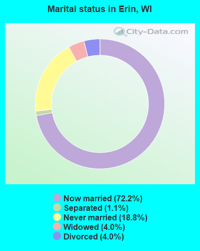
- Never married: 18.8%
- Now married: 72.2%
- Separated: 1.1%
- Widowed: 4.0%
- Divorced: 4.0%
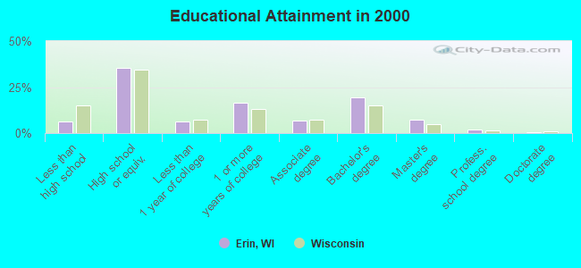
For population 25 years and over in Erin:
- High school or higher: 93.9%
- Bachelor's degree or higher: 29.3%
- Graduate or professional degree: 10.1%
- Unemployed: 3.5%
- Mean travel time to work (commute): 31.9 minutes
| Here: | 9.4 |
| Wisconsin average: | 11.0 |
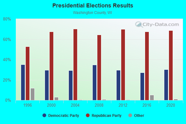
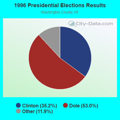


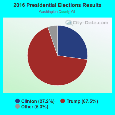

Graphs represent county-level data. Detailed 2008 Election Results
Religion statistics for Erin, WI (based on Washington County data)
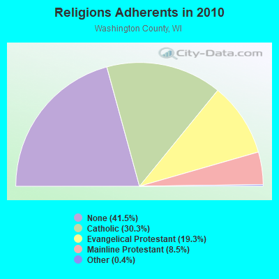
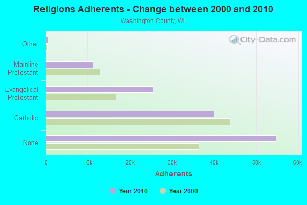
| Religion | Adherents | Congregations |
|---|---|---|
| Catholic | 39,943 | 13 |
| Evangelical Protestant | 25,503 | 49 |
| Mainline Protestant | 11,157 | 30 |
| Other | 532 | 7 |
| Orthodox | 28 | 1 |
| None | 54,724 | - |
Food Environment Statistics:
| Washington County: | 1.25 / 10,000 pop. |
| State: | 1.86 / 10,000 pop. |
| Washington County: | 0.08 / 10,000 pop. |
| Wisconsin: | 0.11 / 10,000 pop. |
| This county: | 0.16 / 10,000 pop. |
| State: | 0.38 / 10,000 pop. |
| Washington County: | 3.83 / 10,000 pop. |
| Wisconsin: | 4.12 / 10,000 pop. |
| Here: | 7.11 / 10,000 pop. |
| Wisconsin: | 8.64 / 10,000 pop. |
| This county: | 6.4% |
| Wisconsin: | 7.6% |
| This county: | 26.5% |
| Wisconsin: | 27.5% |
| Here: | 10.7% |
| Wisconsin: | 13.0% |
Strongest AM radio stations in Erin:
- WTMJ (620 AM; 50 kW; MILWAUKEE, WI; Owner: JOURNAL BROADCAST CORPORATION)
- WISN (1130 AM; 50 kW; MILWAUKEE, WI; Owner: CAPSTAR TX LIMITED PARTNERSHIP)
- WKSH (1640 AM; 10 kW; SUSSEX, WI; Owner: ABC, INC.)
- WTKM (1540 AM; daytime; 0 kW; HARTFORD, WI)
- WAUK (1510 AM; daytime; 10 kW; WAUKESHA, WI; Owner: WALT-WEST WISCONSIN, INC.)
- WNAM (1280 AM; 50 kW; NEENAH-MENASHA, WI; Owner: CUMULUS LICENSING CORP.)
- WBKV (1470 AM; 2 kW; WEST BEND, WI; Owner: WEST BEND BROADCASTING CO.)
- WOKY (920 AM; 5 kW; MILWAUKEE, WI; Owner: CLEAR CHANNEL BROADCASTING LICENSES, INC.)
- WGN (720 AM; 50 kW; CHICAGO, IL; Owner: WGN CONTINENTAL BROADCASTING CO.)
- WSCR (670 AM; 50 kW; CHICAGO, IL; Owner: INFINITY BROADCASTING OPERATIONS, INC.)
- WBBM (780 AM; 50 kW; CHICAGO, IL; Owner: INFINITY BROADCASTING OPERATIONS, INC.)
- WEMP (1250 AM; 5 kW; MILWAUKEE, WI; Owner: ENTERCOM MILWAUKEE LICENSE, LLC)
- WHBY (1150 AM; 25 kW; KIMBERLY, WI; Owner: WOODWARD COMMUNICATIONS, INC.)
Strongest FM radio stations in Erin:
- WTKM-FM (104.9 FM; HARTFORD, WI; Owner: KETTLE MORAINE B/CTING COMPANY, INC.)
- WHAD (90.7 FM; DELAFIELD, WI; Owner: STATE OF WISCONSIN - EDUCATIONAL COMMUNICATIONS BOARD)
- WBWI-FM (92.5 FM; WEST BEND, WI; Owner: WEST BEND BROADCASTING CO.)
- WLTQ (97.3 FM; MILWAUKEE, WI; Owner: CAPSTAR TX LIMITED PARTNERSHIP)
- WMIL-FM (106.1 FM; WAUKESHA, WI; Owner: CLEAR CHANNEL BROADCASTING LICENSES, INC.)
- WJZI (93.3 FM; MILWAUKEE, WI; Owner: MILWAUKEE RADIO ALLIANCE, LLC)
- WKTI-FM (94.5 FM; MILWAUKEE, WI; Owner: JOURNAL BROADCAST CORPORATION)
- WXSS (103.7 FM; WAUWATOSA, WI; Owner: ENTERCOM MILWAUKEE LICENSE, LLC)
- WUWM (89.7 FM; MILWAUKEE, WI; Owner: BOARD OF REGENTS, UNIVERSITY OF WISCONSIN SYSTEM)
- WFZH (105.3 FM; MUKWONAGO, WI; Owner: CARON BROADCASTING, INC.)
- WKLH (96.5 FM; MILWAUKEE, WI; Owner: LAKEFRONT COMMUNICATIONS, LLC)
- WFMR (106.9 FM; BROOKFIELD, WI; Owner: SAGA COMMUNICATIONS OF MILWAUKEE, LLC)
- WLUM-FM (102.1 FM; MILWAUKEE, WI; Owner: MILWAUKEE RADIO ALLIANCE, LLC)
- WMWK (88.1 FM; MILWAUKEE, WI; Owner: FAMILY STATIONS, INC.)
- WRIT-FM (95.7 FM; MILWAUKEE, WI; Owner: CLEAR CHANNEL BROADCASTING LICENSES, INC.)
- WMDC (98.7 FM; MAYVILLE, WI; Owner: RADIO PLUS, INC.)
- WVCY-FM (107.7 FM; MILWAUKEE, WI; Owner: VCY AMERICA, INC.)
- WLZR (102.9 FM; MILWAUKEE, WI; Owner: LAKEFRONT COMMUNICATIONS, LLC)
- WJMR-FM (98.3 FM; MENOMONEE FALLS, WI; Owner: LAKEFRONT COMMUNICATIONS, LLC)
- WMYX-FM (99.1 FM; MILWAUKEE, WI; Owner: ENTERCOM MILWAUKEE LICENSE, LLC)
TV broadcast stations around Erin:
- WWRS-TV (Channel 52; MAYVILLE, WI; Owner: NATIONAL MINORITY T.V., INC.)
- WITI (Channel 6; MILWAUKEE, WI; Owner: WITI LICENSE,INC.)
- WDJT-TV (Channel 58; MILWAUKEE, WI; Owner: WDJT-TV LIMITED PARTNERSHIP)
- WISN-TV (Channel 12; MILWAUKEE, WI; Owner: WISN HEARST-ARGYLE TV, INC. (CA CORP.))
- WPXE (Channel 55; KENOSHA, WI; Owner: PAXSON MILWAUKEE LICENSE, INC.)
- WMVS (Channel 10; MILWAUKEE, WI; Owner: MILWAUKEE AREA TECHNICAL COLLEGE DISTRICT BOARD)
- WMLW-CA (Channel 46; MILWAUKEE, WI; Owner: CHANNEL 41 AND 63 LIMITED PARTNERSHIP)
- WMVT (Channel 36; MILWAUKEE, WI; Owner: MILWAUKEE AREA TECHNICAL COLLEGE DISTRICT BOARD)
- W63CU (Channel 63; MILWAUKEE, WI; Owner: CHANNEL 41 AND 63 LIMITED PARTNERSHIP)
- WCGV-TV (Channel 24; MILWAUKEE, WI; Owner: WCGV LICENSEE, LLC)
- WVTV (Channel 18; MILWAUKEE, WI; Owner: WVTV LICENSEE, INC.)
- WTMJ-TV (Channel 4; MILWAUKEE, WI; Owner: JOURNAL BROADCAST CORPORATION)
- WVCY-TV (Channel 30; MILWAUKEE, WI; Owner: VCY AMERICA, INC.)
- WMMF-TV (Channel 68; FOND DU LAC, WI; Owner: PAPPAS TELECASTING OF WISCONSIN, A CALIFORNIA LTD PARTNRSHP)
- WMKE-CA (Channel 7; MILWAUKEE, WI; Owner: KM LPTV OF MILWAUKEE, L.L.C.)
- WJJA (Channel 49; RACINE, WI; Owner: TV-49, INC.)
- WTAS-LP (Channel 43; WAUKESHA, WI; Owner: WAUKESHA TOWER ASSOCIATES)
- National Bridge Inventory (NBI) Statistics
- 2Number of bridges
- 7ft / 1.7mTotal length
- $157,000Total costs
- 212Total average daily traffic
- 232Total future (year 2039) average daily traffic
FCC Registered Antenna Towers:
3- David Stout, 6995 W Waterford Rd .8 Mi W Of St Hwy 83 (Lat: 43.280000 Lon: -88.383889), Type: 94.8, Structure height: 55131 m, Overall height: 94 m, Registrant: Fmam@wi.Rr.Com, , 270526 Hartf-ord, Phone: (262) 673-7800
- David M Stout, 6995 W Waterford Rd .8 Mi W Of St Hwy 83 (Lat: 43.280000 Lon: -88.383889), Type: 94.8, Structure height: 55131 m, Overall height: 94 m, Registrant: Fmam@wi.Rr.Com, , 270526 Hartf-ord, Phone: (262) 673-7800
- 6995 W Waterford Rd .8 Mi W Of St Hwy 83 (Lat: 43.280000 Lon: -88.383889), Type: 94.8, Overall height: 94 m, Registrant: Kettle Moraine Broadcasting Inc Dba , Wtkm@nconnect.Net, , 216 Hartf-ord, Phone: (414) 673-7800
FCC Registered Broadcast Land Mobile Towers:
1- Lat: 43.252917 Lon: -88.418167, Call Sign: WQOB864,
Assigned Frequencies: 456.537 MHz, 452.712 MHz, 457.712 MHz, 457.100 MHz, 457.112 MHz, 457.125 MHz, 457.137 MHz, 457.150 MHz, 457.162 MHz, 457.175 MHz, 457.187 MHz, 457.200 MHz, Grant Date: 08/05/2011, Expiration Date: 08/28/2011, Cancellation Date: 10/29/2011, Certifier: Pat Mccarty, Registrant: Creative Communications Sales & Rentals Inc, 3332 E Broadway Rd, Phoenix, AZ 85040, Phone: (602) 955-8405, Fax: (602) 955-1049, Email:
FCC Registered Microwave Towers:
1- Erin, Lat: 43.280000 Lon: -88.383889, Type: Tower, Structure height: 94 m, Overall height: 94.8 m, Call Sign: WQJH835,
Assigned Frequencies: 3650.00 MHz, Grant Date: 09/16/2008, Expiration Date: 09/16/2018, Cancellation Date: 11/17/2018, Certifier: Mark E Dodge, Registrant: Granite Wireless, Inc., 300 Industrial Dr, Random Lake, WI 53075, Phone: (920) 994-2388, Email:
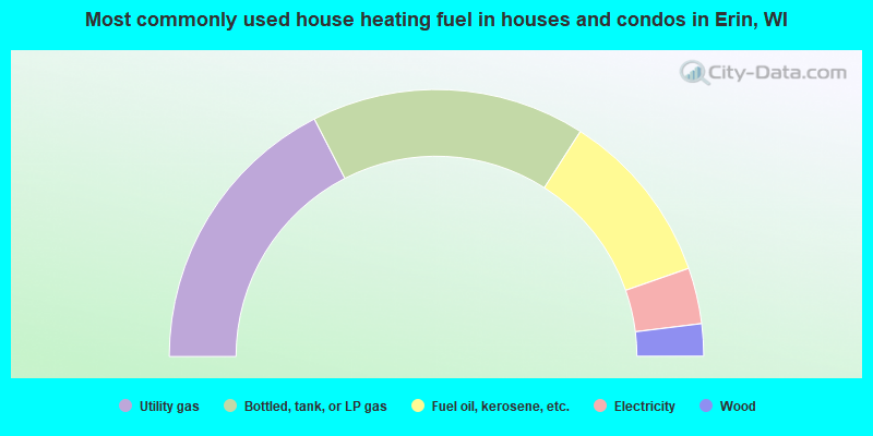
- 34.9%Utility gas
- 33.2%Bottled, tank, or LP gas
- 21.2%Fuel oil, kerosene, etc.
- 6.8%Electricity
- 3.9%Wood
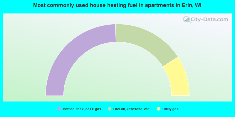
- 49.1%Bottled, tank, or LP gas
- 32.7%Fuel oil, kerosene, etc.
- 18.2%Utility gas
Erin compared to Wisconsin state average:
- Median household income above state average.
- Median house value above state average.
- Unemployed percentage significantly below state average.
- Black race population percentage significantly below state average.
- Hispanic race population percentage significantly below state average.
- Median age above state average.
- Renting percentage significantly below state average.
- Length of stay since moving in significantly above state average.
- Number of rooms per house significantly below state average.
- House age significantly below state average.