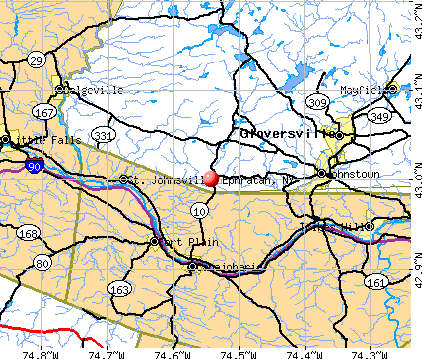
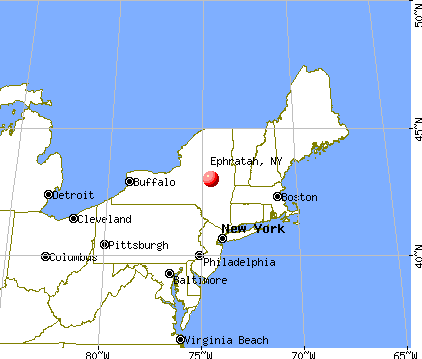
Ephratah, New York
Submit your own pictures of this town and show them to the world
- OSM Map
- General Map
- Google Map
- MSN Map
Population change since 2000: -0.6%
 |
| Males: 874 | |
| Females: 808 |
| Median resident age: | 44.2 years |
| New York median age: | 40.7 years |
Zip codes: 13452.
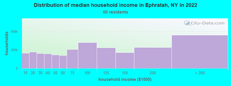
| Ephratah: | $59,455 |
| NY: | $79,557 |
Estimated per capita income in 2022: $29,111 (it was $14,656 in 2000)
Ephratah town income, earnings, and wages data
Estimated median house or condo value in 2022: $121,794 (it was $52,000 in 2000)
| Ephratah: | $121,794 |
| NY: | $400,400 |
Mean prices in 2022: all housing units: $210,218; detached houses: $204,827; townhouses or other attached units: $209,530; in 2-unit structures: $308,153; in 3-to-4-unit structures: $162,839; mobile homes: $108,528
Detailed information about poverty and poor residents in Ephratah, NY


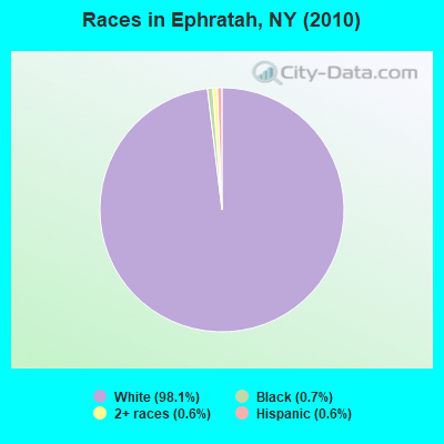
- 1,65098.1%White alone
- 110.7%Black alone
- 100.6%Two or more races
- 100.6%Hispanic
- 10.06%Asian alone
Races in Ephratah detailed stats: ancestries, foreign born residents, place of birth
 Recent articles from our blog. Our writers, many of them Ph.D. graduates or candidates, create easy-to-read articles on a wide variety of topics.


Latest news from Ephratah, NY collected exclusively by city-data.com from local newspapers, TV, and radio stations
Ancestries: German (20.7%), Irish (14.1%), English (9.3%), Dutch (9.3%), Italian (8.0%), United States (7.6%).
Current Local Time: EST time zone
Elevation: 666 feet
Land area: 39.2 square miles.
Population density: 43 people per square mile (very low).
15 residents are foreign born
| This town: | 0.9% |
| New York: | 20.4% |
| Ephratah town: | 2.5% ($1,303) |
| New York: | 1.9% ($2,847) |
Nearest city with pop. 50,000+: Utica, NY  (34.6 miles , pop. 60,651).
Nearest city with pop. 200,000+: Rochester, NY (154.8 miles , pop. 219,773).
Nearest city with pop. 1,000,000+: Bronx, NY (154.8 miles , pop. 1,332,650).
Nearest cities:
), ), ), ), ), )Latitude: 43.03 N, Longitude: 74.55 W
Area code commonly used in this area: 518

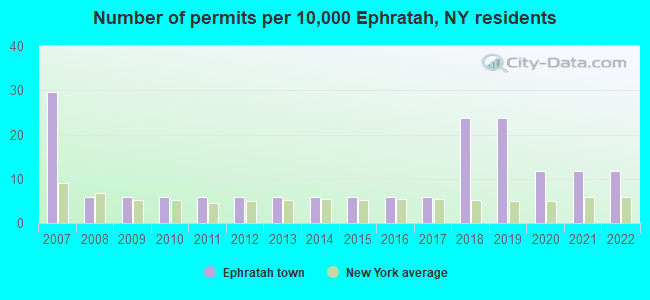
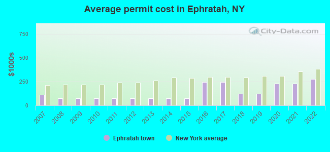
Single-family new house construction building permits:
- 2022: 2 buildings, average cost: $279,200
- 2021: 2 buildings, average cost: $227,000
- 2020: 2 buildings, average cost: $227,000
- 2019: 4 buildings, average cost: $125,000
- 2018: 4 buildings, average cost: $125,000
- 2017: 1 building, cost: $246,000
- 2016: 1 building, cost: $246,000
- 2015: 1 building, cost: $75,000
- 2014: 1 building, cost: $75,000
- 2013: 1 building, cost: $75,000
- 2012: 1 building, cost: $75,000
- 2011: 1 building, cost: $75,000
- 2010: 1 building, cost: $75,000
- 2009: 1 building, cost: $75,000
- 2008: 1 building, cost: $75,000
- 2007: 5 buildings, average cost: $111,000
| Here: | 5.0% |
| New York: | 4.4% |
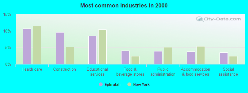
- Health care (10.7%)
- Construction (9.6%)
- Educational services (8.5%)
- Food & beverage stores (4.1%)
- Public administration (3.9%)
- Accommodation & food services (3.8%)
- Social assistance (3.5%)
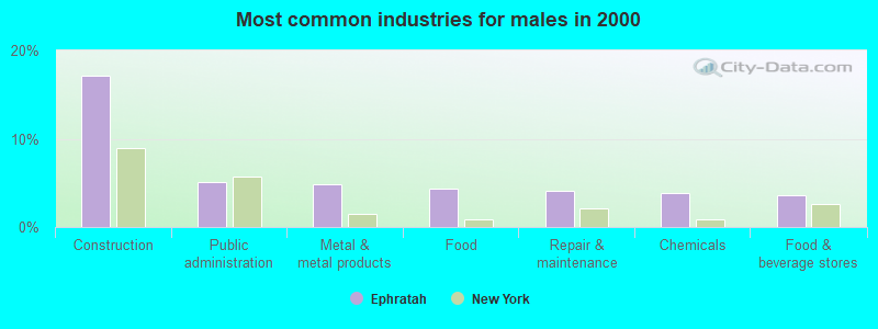
- Construction (17.2%)
- Public administration (5.1%)
- Metal & metal products (4.8%)
- Food (4.4%)
- Repair & maintenance (4.1%)
- Chemicals (3.9%)
- Food & beverage stores (3.6%)
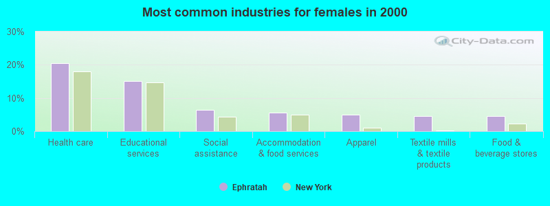
- Health care (20.6%)
- Educational services (15.0%)
- Social assistance (6.4%)
- Accommodation & food services (5.5%)
- Apparel (4.9%)
- Textile mills & textile products (4.6%)
- Food & beverage stores (4.6%)
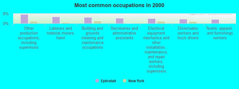
- Other production occupations, including supervisors (7.6%)
- Laborers and material movers, hand (5.7%)
- Building and grounds cleaning and maintenance occupations (5.1%)
- Secretaries and administrative assistants (4.3%)
- Electrical equipment mechanics and other installation, maintenance, and repair workers, including supervisors (4.2%)
- Driver/sales workers and truck drivers (3.5%)
- Textile, apparel, and furnishings workers (3.4%)
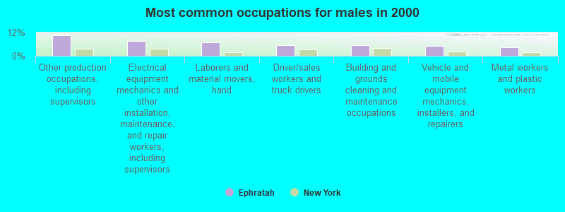
- Other production occupations, including supervisors (10.4%)
- Electrical equipment mechanics and other installation, maintenance, and repair workers, including supervisors (7.5%)
- Laborers and material movers, hand (7.0%)
- Driver/sales workers and truck drivers (5.6%)
- Building and grounds cleaning and maintenance occupations (5.3%)
- Vehicle and mobile equipment mechanics, installers, and repairers (5.1%)
- Metal workers and plastic workers (4.4%)
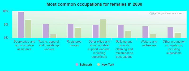
- Secretaries and administrative assistants (9.8%)
- Textile, apparel, and furnishings workers (5.2%)
- Registered nurses (5.2%)
- Other office and administrative support workers, including supervisors (4.9%)
- Building and grounds cleaning and maintenance occupations (4.9%)
- Waiters and waitresses (4.3%)
- Other production occupations, including supervisors (4.0%)
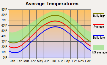
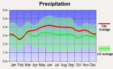
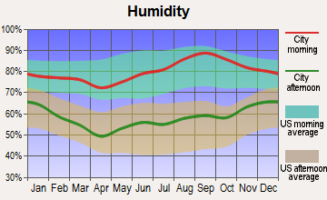
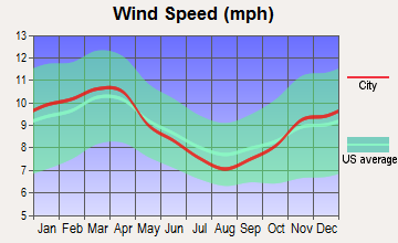
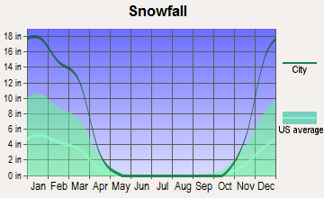
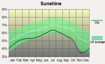
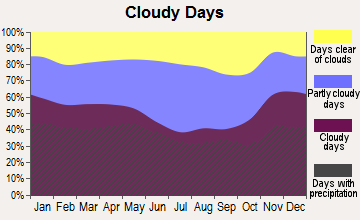
Average climate in Ephratah, New York
Based on data reported by over 4,000 weather stations
Tornado activity:
Ephratah-area historical tornado activity is slightly below New York state average. It is 68% smaller than the overall U.S. average.
On 7/10/1989, a category F4 (max. wind speeds 207-260 mph) tornado 13.7 miles away from the Ephratah town center injured 20 people and caused between $5,000,000 and $50,000,000 in damages.
On 6/16/1974, a category F3 (max. wind speeds 158-206 mph) tornado 34.9 miles away from the town center caused between $500,000 and $5,000,000 in damages.
Earthquake activity:
Ephratah-area historical earthquake activity is significantly above New York state average. It is 68% smaller than the overall U.S. average.On 10/7/1983 at 10:18:46, a magnitude 5.3 (5.1 MB, 5.3 LG, 5.1 ML, Class: Moderate, Intensity: VI - VII) earthquake occurred 64.9 miles away from the city center
On 4/20/2002 at 10:50:47, a magnitude 5.3 (5.3 ML, Depth: 3.0 mi) earthquake occurred 111.3 miles away from the city center
On 4/20/2002 at 10:50:47, a magnitude 5.2 (5.2 MB, 4.2 MS, 5.2 MW, 5.0 MW) earthquake occurred 109.3 miles away from Ephratah center
On 1/19/1982 at 00:14:42, a magnitude 4.7 (4.5 MB, 4.7 MD, 4.5 LG, Class: Light, Intensity: IV - V) earthquake occurred 152.3 miles away from the city center
On 6/17/1991 at 08:53:16, a magnitude 4.1 (4.0 MB, 4.0 LG, Depth: 3.1 mi) earthquake occurred 28.2 miles away from the city center
On 8/23/2011 at 17:51:04, a magnitude 5.8 (5.8 MW, Depth: 3.7 mi) earthquake occurred 396.1 miles away from the city center
Magnitude types: regional Lg-wave magnitude (LG), body-wave magnitude (MB), duration magnitude (MD), local magnitude (ML), surface-wave magnitude (MS), moment magnitude (MW)
Natural disasters:
The number of natural disasters in Fulton County (15) is near the US average (15).Major Disasters (Presidential) Declared: 7
Emergencies Declared: 6
Causes of natural disasters: Storms: 5, Floods: 4, Hurricanes: 3, Snowstorms: 2, Blizzard: 1, Power Outage: 1, Tornado: 1, Tropical Storm: 1, Wind: 1, Winter Storm: 1, Other: 2 (Note: some incidents may be assigned to more than one category).
Hospitals and medical centers near Ephratah:
- ST JOHNSVILLE REHAB AND NURSING (Nursing Home, about 8 miles away; SAINT JOHNSVILLE, NY)
- PALATINE NURSING HOME (Nursing Home, about 9 miles away; PALATINE BRIDGE, NY)
- WELLS NURSING HOME INC (Nursing Home, about 10 miles away; JOHNSTOWN, NY)
- JOHNSTOWN HOSPITAL (Hospital, about 10 miles away; JOHNSTOWN, NY)
- MOUNTAIN VALLEY HOSPICE (Hospital, about 12 miles away; GLOVERSVILLE, NY)
- NATHAN LITTAUER HOSPITAL Acute Care Hospitals (about 12 miles away; GLOVERSVILLE, NY)
- BASSETT HEALTHCARE LITTLE FALLS DIALYSIS (Dialysis Facility, about 15 miles away; LITTLE FALLS, NY)
Colleges/universities with over 2000 students nearest to Ephratah:
- Fulton-Montgomery Community College (about 14 miles; Johnstown, NY; Full-time enrollment: 2,043)
- Herkimer County Community College (about 23 miles; Herkimer, NY; FT enrollment: 2,774)
- SUNY College of Agriculture and Technology at Cobleskill (about 26 miles; Cobleskill, NY; FT enrollment: 2,455)
- Mohawk Valley Community College (about 34 miles; Utica, NY; FT enrollment: 5,693)
- Schenectady County Community College (about 34 miles; Schenectady, NY; FT enrollment: 3,676)
- Union College (about 35 miles; Schenectady, NY; FT enrollment: 2,075)
- Utica College (about 37 miles; Utica, NY; FT enrollment: 2,952)
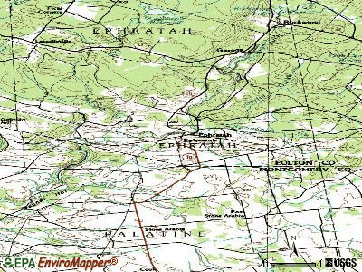
Points of interest:
Notable locations in Ephratah: Acadian Farm (A), Mud Road Farm (B), Fical Corners (C), Canary Dairy (D), Lassellsville Fire House Volunteer Company (E), Ephratah Volunteer Fire Department (F), Rockwood Fire House (G). Display/hide their locations on the map
Cemeteries: Ephratah Rural Cemetery (1), Dempster Cemetery (2), Rockwood Rural Cemetery (3), Fical Cemetery (4), Dillaborough Cemetery (5), Getman Cemetery (6), Micheal Cemetery (7). Display/hide their locations on the map
Reservoirs: Fort Plain Reservoir (A), Saint Johnsville Reservoir (B). Display/hide their locations on the map
Creeks: Sponable Creek (A), Sprite Creek (B), North Creek (C). Display/hide their locations on the map
Park in Ephratah: Adirondack State Park (1). Display/hide its location on the map
| This town: | 2.5 people |
| New York: | 2.6 people |
| This town: | 69.5% |
| Whole state: | 63.5% |
| This town: | 14.8% |
| Whole state: | 6.8% |
Likely homosexual households (counted as self-reported same-sex unmarried-partner households)
- Lesbian couples: 0.3% of all households
- Gay men: 0.6% of all households
| This town: | 15.3% |
| Whole state: | 14.6% |
| This town: | 6.4% |
| Whole state: | 7.4% |
22 people in homes for the mentally retarded in 2000
For population 15 years and over in Ephratah:
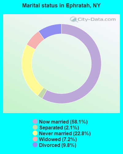
- Never married: 22.8%
- Now married: 58.1%
- Separated: 2.1%
- Widowed: 7.2%
- Divorced: 9.8%
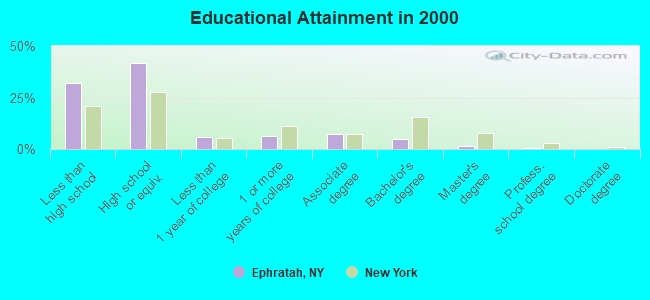
For population 25 years and over in Ephratah:
- High school or higher: 67.9%
- Bachelor's degree or higher: 6.7%
- Graduate or professional degree: 1.9%
- Unemployed: 7.5%
- Mean travel time to work (commute): 29.2 minutes
| Here: | 11.2 |
| New York average: | 14.2 |
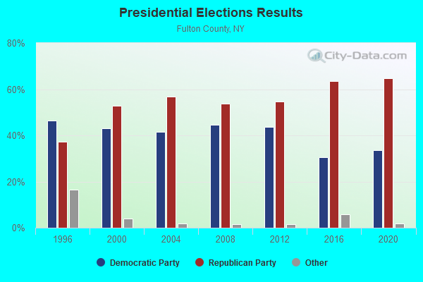
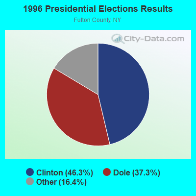
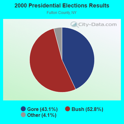

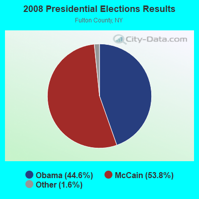
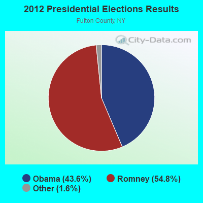
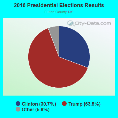
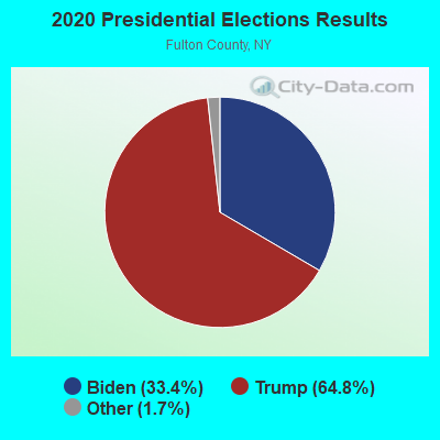
Graphs represent county-level data. Detailed 2008 Election Results
Religion statistics for Ephratah, NY (based on Fulton County data)
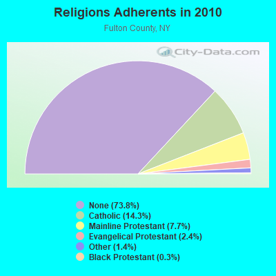
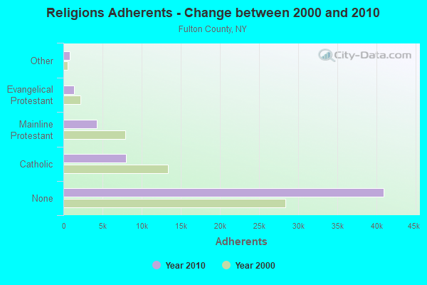
| Religion | Adherents | Congregations |
|---|---|---|
| Catholic | 7,963 | 4 |
| Mainline Protestant | 4,264 | 22 |
| Evangelical Protestant | 1,351 | 20 |
| Other | 793 | 4 |
| Black Protestant | 156 | 2 |
| Orthodox | 30 | 1 |
| None | 40,974 | - |
Food Environment Statistics:
| This county: | 1.82 / 10,000 pop. |
| State: | 4.13 / 10,000 pop. |
| Fulton County: | 1.09 / 10,000 pop. |
| New York: | 0.92 / 10,000 pop. |
| Here: | 3.28 / 10,000 pop. |
| New York: | 1.68 / 10,000 pop. |
| Here: | 8.92 / 10,000 pop. |
| State: | 8.82 / 10,000 pop. |
| Here: | 8.0% |
| New York: | 8.2% |
| This county: | 25.7% |
| New York: | 23.8% |
| Fulton County: | 14.6% |
| State: | 15.6% |
Strongest AM radio stations in Ephratah:
- WGY (810 AM; 50 kW; SCHENECTADY, NY; Owner: CLEAR CHANNEL BROADCASTING LICENSES, INC.)
- WPTR (1540 AM; 50 kW; ALBANY, NY; Owner: KIMTRON, INC.)
- WIZR (930 AM; 1 kW; JOHNSTOWN, NY; Owner: 6 JOHNSON ROAD LICENSES, INC.)
- WENT (1340 AM; 1 kW; GLOVERSVILLE, NY; Owner: WHITNEY RADIO BROADCASTING, INC.)
- WNNZ (640 AM; 50 kW; WESTFIELD, MA; Owner: CLEAR CHANNEL BROADCASTING LICENSES, INC.)
- WFNY (1440 AM; 1 kW; GLOVERSVILLE, NY; Owner: MICHAEL A. SLEEZER)
- WLFH (1230 AM; 1 kW; LITTLE FALLS, NY; Owner: CLEAR CHANNEL BROADCASTING LICENSES, INC.)
- WMCA (570 AM; 50 kW; NEW YORK, NY; Owner: SALEM MEDIA OF NEW YORK, LLC)
- WIBX (950 AM; 5 kW; UTICA, NY; Owner: REGENT LICENSEE OF UTICA/ROME, INC.)
- WROW (590 AM; 5 kW; ALBANY, NY; Owner: 6 JOHNSON ROAD LICENSES, INC.)
- WOFX (980 AM; 5 kW; TROY, NY)
- WTIC (1080 AM; 50 kW; HARTFORD, CT; Owner: INFINITY RADIO OPERATIONS INC.)
- WFAN (660 AM; 50 kW; NEW YORK, NY; Owner: INFINITY BROADCASTING OPERATIONS, INC.)
Strongest FM radio stations in Ephratah:
- WQBJ (103.5 FM; COBLESKILL, NY; Owner: REGENT LICENSEE OF MANSFIELD, INC.)
- WBUG-FM (101.1 FM; FORT PLAIN, NY; Owner: ROSER COMMUNICATIONS NETWORK, INC.)
- WJIV (101.9 FM; CHERRY VALLEY, NY; Owner: CHRISTIAN BROADCASTING SYSTEM, LTD.)
- WCAN (93.3 FM; CANAJOHARIE, NY; Owner: W A M C)
- WSKU (105.5 FM; LITTLE FALLS, NY; Owner: CLEAR CHANNEL BROADCASTING LICENSES, INC.)
- WBKK (97.7 FM; AMSTERDAM, NY; Owner: GEM ASSOCIATES, L. P.)
- WXLG (89.9 FM; NORTH CREEK, NY; Owner: THE ST. LAWRENCE UNIVERSITY)
- WBGK (99.7 FM; NEWPORT VILLAGE, NY; Owner: ROSER COMMUNICATIONS NETWORK, INC.)
- WGKR (105.3 FM; GRAND GORGE, NY; Owner: SOUND OF LIFE, INC.)
- WMYY (97.3 FM; SCHOHARIE, NY; Owner: CAPITAL MEDIA CORPORATION)
- WAJZ (96.3 FM; VOORHEESVILLE, NY; Owner: 6 JOHNSON ROAD LICENSES, INC.)
- WPGL (90.7 FM; PATTERSONVILLE, NY; Owner: SOUND OF LIFE, INC.)
- WZMR (104.9 FM; ALTAMONT, NY; Owner: 6 JOHNSON ROAD LICENSES, INC.)
- WYJB (95.5 FM; ALBANY, NY; Owner: 6 JOHNSON ROAD LICENSES, INC.)
- WOUR (96.9 FM; UTICA, NY; Owner: CLEAR CHANNEL BROADCASTING LICENSES, INC.)
- WUNY (89.5 FM; UTICA, NY; Owner: PUBLIC BC COUNCIL OF CENTRAL NY, INC)
- WKBE (100.3 FM; WARRENSBURG, NY; Owner: 6 JOHNSON ROAD LICENSES, INC.)
- WGNA-FM (107.7 FM; ALBANY, NY; Owner: REGENT LICENSEE OF MANSFIELD, INC.)
- WCKM-FM (99.1 FM; LAKE GEORGE, NY; Owner: ENTERTRONICS, INC.)
- WNYQ (105.7 FM; QUEENSBURY, NY; Owner: VOX NEW YORK, L.L.C.)
TV broadcast stations around Ephratah:
- WKTV (Channel 2; UTICA, NY; Owner: SMITH TELEVISION OF NEW YORK LICENSE HOLDINGS, INC.)
- WYPX (Channel 55; AMSTERDAM, NY; Owner: PAXSON ALBANY LICENSE, INC.)
- WFNY-CA (Channel 49; GLOVERSVILLE, NY; Owner: MICHAEL A. SLEEZER)
- W31BP (Channel 31; BURLINGTON, ETC., NY; Owner: QUORUM OF UTICA LICENSE, LLC)
Medal of Honor Recipients
Medal of Honor Recipient born in Ephratah: Douglas Hapeman.
- National Bridge Inventory (NBI) Statistics
- 7Number of bridges
- 36ft / 10.7mTotal length
- $3,663,000Total costs
- 4,203Total average daily traffic
- 476Total average daily truck traffic
- 4,686Total future (year 2036) average daily traffic
FCC Registered Microwave Towers:
1- EPHRATAH, 201 East Road (Lat: 43.057333 Lon: -74.586361), Type: Ltower, Structure height: 52.4 m, Call Sign: WQQG726,
Assigned Frequencies: 6675.00 MHz, 6665.00 MHz, Grant Date: 09/09/2022, Expiration Date: 12/06/2032, Certifier: Timothy A Lilly, Registrant: Eastern Gas Transmission And Storage, Inc., 925 White Oaks Blvd., Bridgeport, WV 26330, Phone: (681) 842-3701, Email:
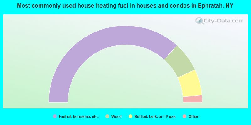
- 73.4%Fuel oil, kerosene, etc.
- 12.6%Wood
- 11.0%Bottled, tank, or LP gas
- 1.9%Electricity
- 0.7%Other fuel
- 0.4%Utility gas
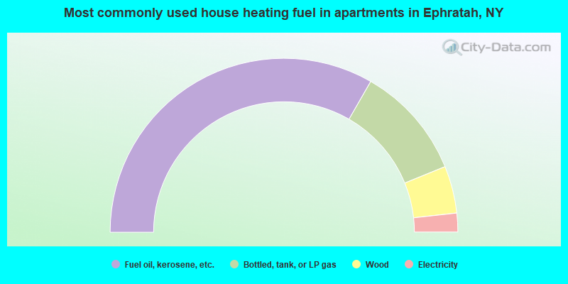
- 66.7%Fuel oil, kerosene, etc.
- 21.1%Bottled, tank, or LP gas
- 8.8%Wood
- 3.5%Electricity
Ephratah compared to New York state average:
- Median house value significantly below state average.
- Unemployed percentage below state average.
- Black race population percentage significantly below state average.
- Hispanic race population percentage significantly below state average.
- Foreign-born population percentage significantly below state average.
- Renting percentage significantly below state average.
- Length of stay since moving in significantly above state average.
- Number of rooms per house significantly below state average.
- House age significantly below state average.
- Number of college students below state average.
- Percentage of population with a bachelor's degree or higher significantly below state average.