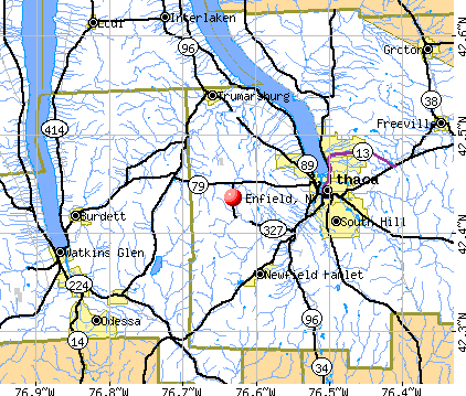
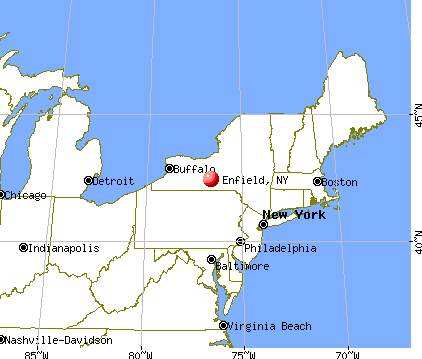
Enfield, New York
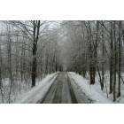
Enfield: Vandorn Road, Enfield Ny after an ice storm
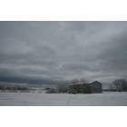
Enfield: Close to the Corner of Vandorn and Hayts roads. The large field is an airplane landing strip for local private planes.
Enfield: Vandorn Road, Enfield Ny after an ice storm
- add
your
Submit your own pictures of this town and show them to the world
- OSM Map
- General Map
- Google Map
- MSN Map
Population change since 2000: +4.2%
 |
| Males: 1,713 | |
| Females: 1,799 |
| Median resident age: | 41.2 years |
| New York median age: | 40.7 years |
Zip codes: 14850.
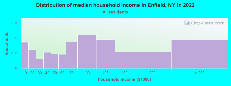
| Enfield: | $72,576 |
| NY: | $79,557 |
Estimated per capita income in 2022: $34,088 (it was $16,795 in 2000)
Enfield town income, earnings, and wages data
Estimated median house or condo value in 2022: $215,409 (it was $73,300 in 2000)
| Enfield: | $215,409 |
| NY: | $400,400 |
Mean prices in 2022: all housing units: $300,865; detached houses: $326,040; townhouses or other attached units: $377,155; in 2-unit structures: $261,861; in 3-to-4-unit structures: $266,062; in 5-or-more-unit structures: $447,005; mobile homes: $106,782
Detailed information about poverty and poor residents in Enfield, NY


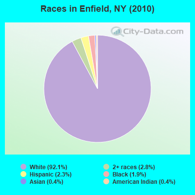
- 3,23392.1%White alone
- 992.8%Two or more races
- 802.3%Hispanic
- 671.9%Black alone
- 140.4%American Indian alone
- 150.4%Asian alone
- 30.09%Other race alone
- 10.03%Native Hawaiian and Other
Pacific Islander alone
Races in Enfield detailed stats: ancestries, foreign born residents, place of birth
 Recent articles from our blog. Our writers, many of them Ph.D. graduates or candidates, create easy-to-read articles on a wide variety of topics.

 | smaller Upstate NY cities and towns/African American communities (5974 replies) |
| Costco coming to Guilderland (58 replies) |
| From Long Island to the Burbs in Rochester...Help Please? (79 replies) |
| Corning, Ithaca, Watkins Glen, Trumansburg (11 replies) |
| Which Borough has the most de-tached single family homes? (50 replies) |
| Let's talk Southern Tier (21 replies) |
Latest news from Enfield, NY collected exclusively by city-data.com from local newspapers, TV, and radio stations
Ancestries: English (19.5%), Irish (17.3%), German (16.9%), Italian (9.4%), United States (7.7%), Dutch (7.0%).
Current Local Time: EST time zone
Land area: 36.9 square miles.
Population density: 95 people per square mile (very low).
103 residents are foreign born (1.9% Europe, 0.5% Latin America, 0.4% Asia).
| This town: | 3.1% |
| New York: | 20.4% |
| Enfield town: | 2.5% ($1,820) |
| New York: | 1.9% ($2,847) |
Nearest city with pop. 50,000+: Union, NY (38.1 miles  , pop. 56,298).
Nearest city with pop. 200,000+: Rochester, NY (71.1 miles , pop. 219,773).
Nearest city with pop. 1,000,000+: Manhattan, NY (179.2 miles , pop. 1,537,195).
Nearest cities:
), ), ), ), Latitude: 42.44 N, Longitude: 76.63 W
Area code commonly used in this area: 607

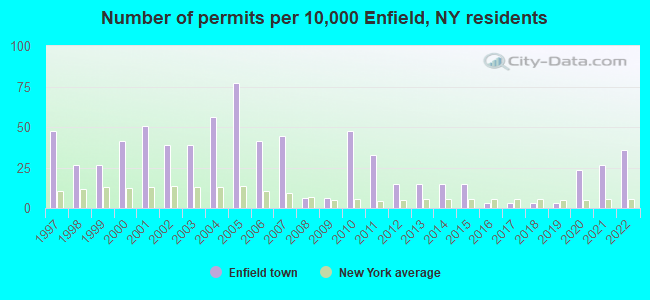
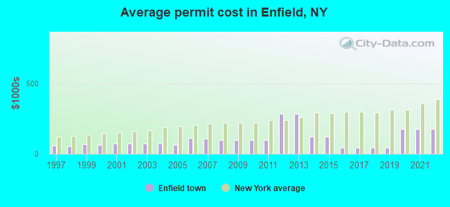
Single-family new house construction building permits:
- 2022: 12 buildings, average cost: $176,300
- 2021: 9 buildings, average cost: $176,300
- 2020: 8 buildings, average cost: $176,300
- 2019: 1 building, cost: $45,000
- 2018: 1 building, cost: $45,000
- 2017: 1 building, cost: $45,000
- 2016: 1 building, cost: $45,000
- 2015: 5 buildings, average cost: $120,000
- 2014: 5 buildings, average cost: $120,000
- 2013: 5 buildings, average cost: $283,400
- 2012: 5 buildings, average cost: $283,400
- 2011: 11 buildings, average cost: $99,600
- 2010: 16 buildings, average cost: $99,600
- 2009: 2 buildings, average cost: $100,000
- 2008: 2 buildings, average cost: $100,000
- 2007: 15 buildings, average cost: $104,900
- 2006: 14 buildings, average cost: $111,900
- 2005: 26 buildings, average cost: $64,600
- 2004: 19 buildings, average cost: $72,000
- 2003: 13 buildings, average cost: $70,500
- 2002: 13 buildings, average cost: $70,500
- 2001: 17 buildings, average cost: $72,100
- 2000: 14 buildings, average cost: $63,300
- 1999: 9 buildings, average cost: $66,900
- 1998: 9 buildings, average cost: $51,600
- 1997: 16 buildings, average cost: $58,800
| Here: | 3.5% |
| New York: | 4.4% |
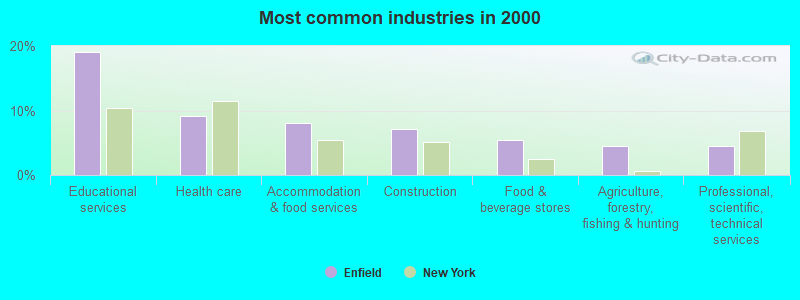
- Educational services (19.0%)
- Health care (9.2%)
- Accommodation & food services (8.1%)
- Construction (7.2%)
- Food & beverage stores (5.4%)
- Agriculture, forestry, fishing & hunting (4.6%)
- Professional, scientific, technical services (4.5%)
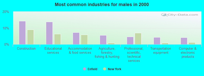
- Construction (14.2%)
- Educational services (13.9%)
- Accommodation & food services (7.3%)
- Agriculture, forestry, fishing & hunting (5.5%)
- Professional, scientific, technical services (4.6%)
- Transportation equipment (4.4%)
- Computer & electronic products (4.2%)
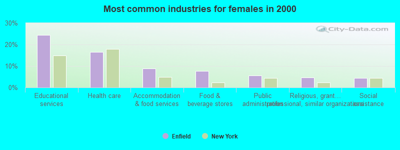
- Educational services (24.3%)
- Health care (16.4%)
- Accommodation & food services (8.9%)
- Food & beverage stores (7.6%)
- Public administration (5.6%)
- Religious, grantmaking, civic, professional, similar organizations (4.6%)
- Social assistance (4.5%)
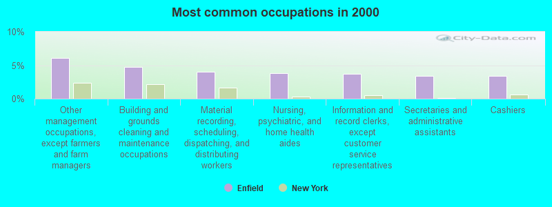
- Other management occupations, except farmers and farm managers (6.1%)
- Building and grounds cleaning and maintenance occupations (4.7%)
- Material recording, scheduling, dispatching, and distributing workers (4.1%)
- Nursing, psychiatric, and home health aides (3.8%)
- Information and record clerks, except customer service representatives (3.7%)
- Secretaries and administrative assistants (3.4%)
- Cashiers (3.4%)
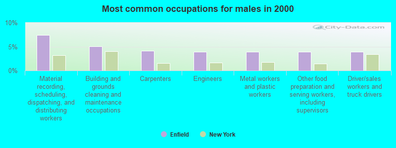
- Material recording, scheduling, dispatching, and distributing workers (7.4%)
- Building and grounds cleaning and maintenance occupations (5.1%)
- Carpenters (4.2%)
- Engineers (3.9%)
- Metal workers and plastic workers (3.9%)
- Other food preparation and serving workers, including supervisors (3.9%)
- Driver/sales workers and truck drivers (3.9%)
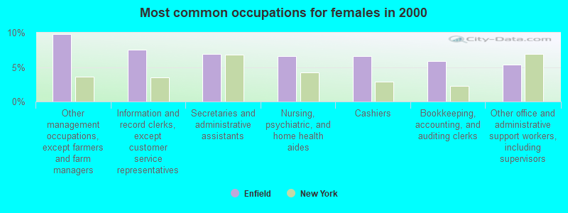
- Other management occupations, except farmers and farm managers (9.8%)
- Information and record clerks, except customer service representatives (7.5%)
- Secretaries and administrative assistants (6.9%)
- Nursing, psychiatric, and home health aides (6.6%)
- Cashiers (6.6%)
- Bookkeeping, accounting, and auditing clerks (5.9%)
- Other office and administrative support workers, including supervisors (5.3%)
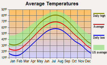
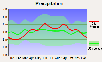
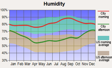
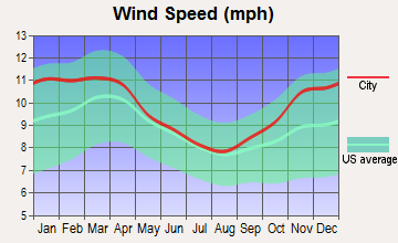
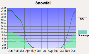
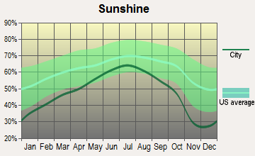
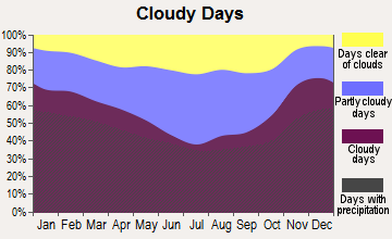
Average climate in Enfield, New York
Based on data reported by over 4,000 weather stations
(lower is better)
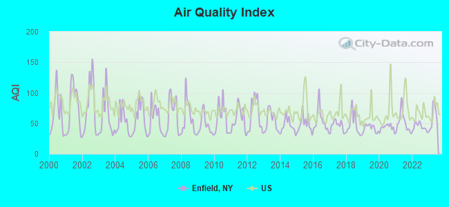
Air Quality Index (AQI) level in 2023 was 59.0. This is better than average.
| City: | 59.0 |
| U.S.: | 72.6 |
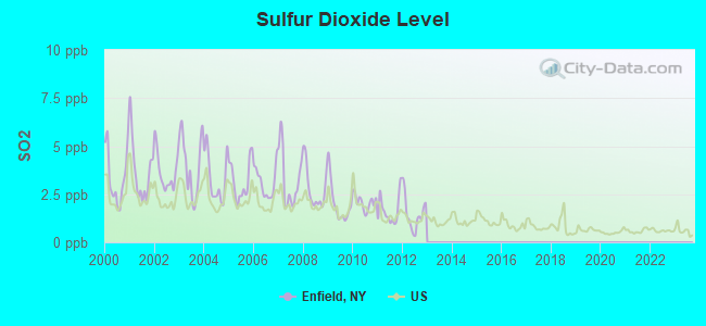
Sulfur Dioxide (SO2) [ppb] level in 2012 was 1.48. This is about average. Closest monitor was 2.8 miles away from the city center.
| City: | 1.48 |
| U.S.: | 1.51 |
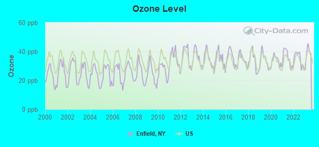
Ozone [ppb] level in 2023 was 38.5. This is about average. Closest monitor was 2.7 miles away from the city center.
| City: | 38.5 |
| U.S.: | 33.3 |
Tornado activity:
Enfield-area historical tornado activity is slightly below New York state average. It is 67% smaller than the overall U.S. average.
On 8/30/1955, a category F3 (max. wind speeds 158-206 mph) tornado 16.7 miles away from the Enfield town center caused between $5000 and $50,000 in damages.
On 5/2/1983, a category F3 tornado 28.2 miles away from the town center injured 6 people and caused between $500,000 and $5,000,000 in damages.
Earthquake activity:
Enfield-area historical earthquake activity is significantly above New York state average. It is 67% smaller than the overall U.S. average.On 10/7/1983 at 10:18:46, a magnitude 5.3 (5.1 MB, 5.3 LG, 5.1 ML, Class: Moderate, Intensity: VI - VII) earthquake occurred 155.8 miles away from Enfield center
On 4/20/2002 at 10:50:47, a magnitude 5.3 (5.3 ML, Depth: 3.0 mi) earthquake occurred 205.5 miles away from the city center
On 4/20/2002 at 10:50:47, a magnitude 5.2 (5.2 MB, 4.2 MS, 5.2 MW, 5.0 MW) earthquake occurred 203.6 miles away from the city center
On 9/25/1998 at 19:52:52, a magnitude 5.2 (4.8 MB, 4.3 MS, 5.2 LG, 4.5 MW, Depth: 3.1 mi) earthquake occurred 204.5 miles away from Enfield center
On 8/23/2011 at 17:51:04, a magnitude 5.8 (5.8 MW, Depth: 3.7 mi) earthquake occurred 320.6 miles away from Enfield center
On 1/16/1994 at 01:49:16, a magnitude 4.6 (4.6 MB, 4.6 LG, Depth: 3.1 mi, Class: Light, Intensity: IV - V) earthquake occurred 148.8 miles away from the city center
Magnitude types: regional Lg-wave magnitude (LG), body-wave magnitude (MB), local magnitude (ML), surface-wave magnitude (MS), moment magnitude (MW)
Natural disasters:
The number of natural disasters in Tompkins County (17) is near the US average (15).Major Disasters (Presidential) Declared: 11
Emergencies Declared: 5
Causes of natural disasters: Floods: 7, Storms: 7, Heavy Rains: 2, Hurricanes: 2, Tropical Storms: 2, Blizzard: 1, Landslide: 1, Power Outage: 1, Snowstorm: 1, Winter Storm: 1, Other: 2 (Note: some incidents may be assigned to more than one category).
Hospitals and medical centers near Enfield:
- CAYUGA RIDGE EXTENDED CARE (Nursing Home, about 6 miles away; ITHACA, NY)
- CAYUGA MEDICAL CENTER AT ITHACA Acute Care Hospitals (about 6 miles away; ITHACA, NY)
- ITHACA DIALYSIS CLINIC (Dialysis Facility, about 6 miles away; ITHACA, NY)
- BEECHTREE CARE CENTER (Nursing Home, about 7 miles away; ITHACA, NY)
- OAK HILL MANOR NURSING HOME (Nursing Home, about 7 miles away; ITHACA, NY)
- HOSPICARE AND PALLIATIVE SVCS OF TOMPKINS CO INC (Hospital, about 8 miles away; ITHACA, NY)
- KENDAL AT ITHACA (Nursing Home, about 8 miles away; ITHACA, NY)
Colleges/universities with over 2000 students nearest to Enfield:
- Ithaca College (about 7 miles; Ithaca, NY; Full-time enrollment: 6,781)
- Cornell University (about 8 miles; Ithaca, NY; FT enrollment: 20,360)
- Tompkins Cortland Community College (about 18 miles; Dryden, NY; FT enrollment: 3,884)
- SUNY College at Cortland (about 25 miles; Cortland, NY; FT enrollment: 6,838)
- Corning Community College (about 32 miles; Corning, NY; FT enrollment: 3,036)
- Hobart William Smith Colleges (about 35 miles; Geneva, NY; FT enrollment: 2,476)
- Cayuga County Community College (about 36 miles; Auburn, NY; FT enrollment: 3,141)
Points of interest:
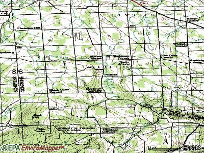
Notable locations in Enfield: Millers Corners (A), Black Oaks Corners (B), Hillendale Golf Course (C), Pinecreek Campground (D), Enfield Town Hall (E). Display/hide their locations on the map
Churches in Enfield include: Agape Bible Church (A), Enfield United Methodist Church (B), First Baptist Church of Enfield (C). Display/hide their locations on the map
Cemeteries: Rolfe Cemetery (1), Budd Cemetery (2), Rumsey Hill Cemetery (3), Christian Cemetery (4), Presbyterian Cemetery (5), Woodward Cemetery (6). Display/hide their locations on the map
Streams, rivers, and creeks: Fish Kill (A), Fivemile Creek (B), Enfield Creek (C). Display/hide their locations on the map
Park in Enfield: Robert H Treman State park (1). Display/hide its location on the map
Birthplace of: Curry Hicks - Football coach.
| This town: | 2.4 people |
| New York: | 2.6 people |
| This town: | 63.3% |
| Whole state: | 63.5% |
| This town: | 11.4% |
| Whole state: | 6.8% |
Likely homosexual households (counted as self-reported same-sex unmarried-partner households)
- Lesbian couples: 1.6% of all households
- Gay men: 0.3% of all households
| This town: | 13.5% |
| Whole state: | 14.6% |
| This town: | 3.3% |
| Whole state: | 7.4% |
For population 15 years and over in Enfield:
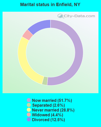
- Never married: 28.8%
- Now married: 51.7%
- Separated: 2.6%
- Widowed: 4.4%
- Divorced: 12.5%
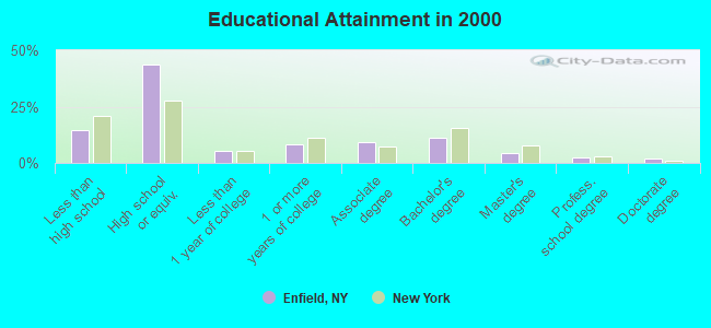
For population 25 years and over in Enfield:
- High school or higher: 85.6%
- Bachelor's degree or higher: 19.8%
- Graduate or professional degree: 8.8%
- Unemployed: 6.2%
- Mean travel time to work (commute): 22.8 minutes
| Here: | 10.5 |
| New York average: | 14.2 |
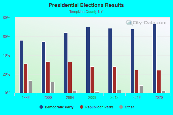
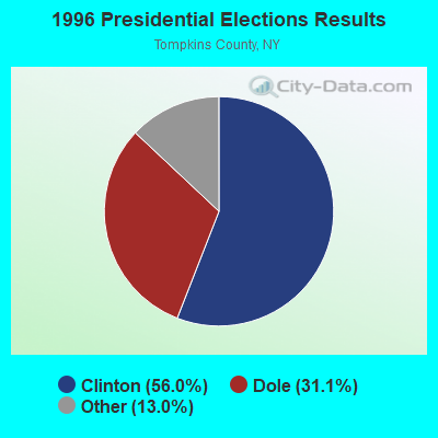

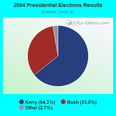
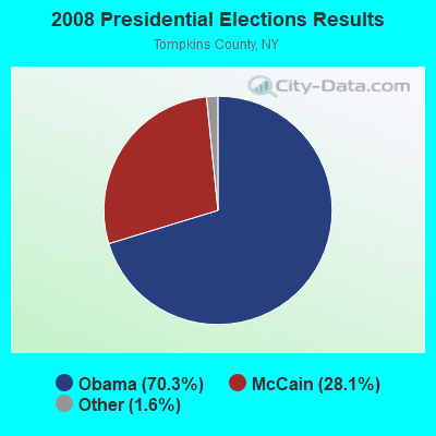
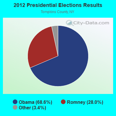
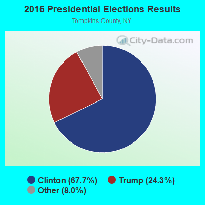
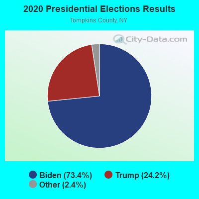
Graphs represent county-level data. Detailed 2008 Election Results
Religion statistics for Enfield, NY (based on Tompkins County data)
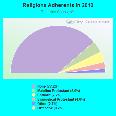
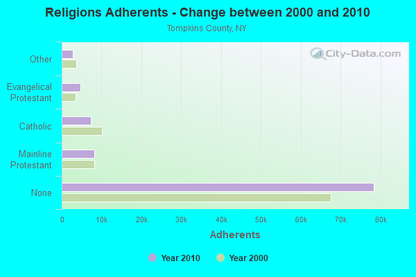
| Religion | Adherents | Congregations |
|---|---|---|
| Mainline Protestant | 8,102 | 34 |
| Catholic | 7,344 | 7 |
| Evangelical Protestant | 4,649 | 36 |
| Other | 2,788 | 13 |
| Orthodox | 215 | 1 |
| Black Protestant | 57 | 1 |
| None | 78,409 | - |
Food Environment Statistics:
| Tompkins County: | 1.89 / 10,000 pop. |
| New York: | 4.13 / 10,000 pop. |
| Tompkins County: | 0.70 / 10,000 pop. |
| New York: | 0.92 / 10,000 pop. |
| Tompkins County: | 2.39 / 10,000 pop. |
| New York: | 1.68 / 10,000 pop. |
| Tompkins County: | 10.46 / 10,000 pop. |
| New York: | 8.82 / 10,000 pop. |
| Tompkins County: | 6.0% |
| New York: | 8.2% |
| This county: | 25.3% |
| State: | 23.8% |
| Tompkins County: | 12.8% |
| New York: | 15.6% |
Strongest AM radio stations in Enfield:
- WPIE (1160 AM; 5 kW; TRUMANSBURG, NY; Owner: PEMBROOK PINES ITHACA LTD. N.A.)
- WTKO (1470 AM; 5 kW; ITHACA, NY; Owner: EAGLE II BROADCASTING CORPORATION)
- WHCU (870 AM; 5 kW; ITHACA, NY; Owner: EAGLE BROADCASTING COMPANY, INC.)
- WLNL (1000 AM; daytime; 5 kW; HORSEHEADS, NY; Owner: LIGHTHOUSE MEDIA, INC.)
- WWLZ (820 AM; 4 kW; HORSEHEADS, NY; Owner: CHEMUNG COUNTY RADIO, INC.)
- WHAM (1180 AM; 50 kW; ROCHESTER, NY; Owner: CITICASTERS LICENSES, L.P.)
- WFLR (1570 AM; 5 kW; DUNDEE, NY; Owner: LAKES COUNTY COMMUNICATION CORP.)
- WEHH (1590 AM; 5 kW; ELMIRA HTS/HORSEHEAD, NY; Owner: PEMBROOK PINES ELMIRA, LTD.)
- WELM (1410 AM; 5 kW; ELMIRA, NY; Owner: PEMBROOK PINES ELMIRA, LIMITED)
- WABH (1380 AM; 10 kW; BATH, NY)
- WATS (960 AM; 5 kW; SAYRE, PA; Owner: WATS BROADCASTING, INC.)
- WEBO (1330 AM; 5 kW; OWEGO, NY; Owner: TIOGA MEDIA, INC.)
- WSYR (570 AM; 5 kW; SYRACUSE, NY; Owner: CLEAR CHANNEL BROADCASTING LICENSES, INC.)
Strongest FM radio stations in Enfield:
- WQNY (103.7 FM; ITHACA, NY; Owner: EAGLE II BROADCASTING CORPORATION)
- WYXL (97.3 FM; ITHACA, NY; Owner: EAGLE BROADCASTING COMPANY)
- WPHR (106.9 FM; AUBURN, NY; Owner: CLEAR CHANNEL BROADCASTING LICENSES, INC.)
- WSQG-FM (90.9 FM; ITHACA, NY; Owner: WSKG PUBLIC TELECOMM. COUNCIL)
- WVBR-FM (93.5 FM; ITHACA, NY; Owner: CORNELL RADIO GUILD, INC.)
- WOKN (99.5 FM; SOUTHPORT, NY; Owner: PEMBROOK PINES ELMIRA, LTD.)
- WLVY (94.3 FM; ELMIRA, NY; Owner: PEMBROOK PINES ELMIRA, LTD.)
- W242AB (96.3 FM; ITHACA, NY; Owner: FAMILY LIFE MINISTRIES, INC.)
- WFLR-FM (95.9 FM; DUNDEE, NY; Owner: LAKES COUNTRY COMMUNICATIONS CORP.)
- WNGZ (104.9 FM; MONTOUR FALLS, NY; Owner: CHEMUNG COUNTY RADIO, INC.)
- WIII (99.9 FM; CORTLAND, NY; Owner: CITADEL BROADCASTING COMPANY)
- W205BR (88.9 FM; ELMIRA, NY; Owner: PENSACOLA CHRISTIAN COLLEGE, INC.)
- WHWK (98.1 FM; BINGHAMTON, NY; Owner: CITADEL BROADCASTING COMPANY)
- WSQE (91.1 FM; CORNING, NY; Owner: WSKG PUB. TELECOMMUNICATIONS COUNCIL)
- WCBA-FM (98.7 FM; CORNING, NY; Owner: EOLIN BROADCASTING, INC.)
- WICB (91.7 FM; ITHACA, NY; Owner: ITHACA COLLEGE)
- WENY-FM (92.7 FM; ELMIRA, NY; Owner: EOLIN BROADCASTING, INC.)
- WGMM (97.7 FM; BIG FLATS, NY; Owner: EOLIN BROADCASTING, INC.)
- WAAL (99.1 FM; BINGHAMTON, NY; Owner: CITADEL BROADCASTING COMPANY)
- WSKG-FM (89.3 FM; BINGHAMTON, NY; Owner: WSKG PUB.TELECOMMUNICATIONS COUNCIL)
TV broadcast stations around Enfield:
- W16AX (Channel 16; ITHACA, NY; Owner: WSYT LICENSEE L.P.)
- WETM-TV (Channel 18; ELMIRA, NY; Owner: SMITH TELEVISION OF NEW YORK LICENSE HOLDINGS, INC.)
- WENY-TV (Channel 36; ELMIRA, NY; Owner: LILLY BROADCASTING, L.L.C.)
- WSYT (Channel 68; SYRACUSE, NY; Owner: WSYT LICENSEE L.P.)
- WCNY-TV (Channel 24; SYRACUSE, NY; Owner: PUBLIC BROADCASTING COUNCIL OF CENTRAL NEW YORK)
- W20BT (Channel 20; ITHACA, NY; Owner: NATIONAL MINORITY T.V., INC.)
- W07BJ (Channel 7; ITHACA, NY; Owner: LILLY BROADCASTING, L.L.C.)
- W59DG (Channel 59; ELMIRA, NY; Owner: TRINITY BROADCASTING NETWORK)
- W21BW (Channel 21; ELMIRA, NY; Owner: THREE ANGELS BROADCASTING NETWORK INC.)
- National Bridge Inventory (NBI) Statistics
- 10Number of bridges
- 49ft / 15.1mTotal length
- $8,823,000Total costs
- 5,209Total average daily traffic
- 393Total average daily truck traffic
- 6,245Total future (year 2021) average daily traffic
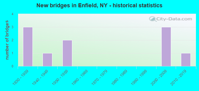
- New bridges - historical statistics
- 31930-1939
- 11940-1949
- 21950-1959
- 32000-2009
- 12010-2019
FCC Registered Antenna Towers:
37 (See the full list of FCC Registered Antenna Towers in Enfield)FCC Registered Broadcast Land Mobile Towers:
1- 6150 Slack Rd. (Lat: 42.471306 Lon: -76.645056), Type: Tower, Structure height: 56.4 m, Overall height: 58.2 m, Call Sign: WQHA201,
Assigned Frequencies: 854.937 MHz, 856.687 MHz, 857.687 MHz, 858.687 MHz, 859.887 MHz, Grant Date: 06/07/2007, Expiration Date: 06/07/2017, Cancellation Date: 10/04/2016, Certifier: Lee Shurtleff, Registrant: Tompkins County Department Of Emergency Response, 91 Brown Rd, Ithaca, NY 14850, Phone: (607) 257-3888, Fax: (607) 257-2314, Email:
FCC Registered Microwave Towers:
4- ITHACA, Off Bostwick Rd & Int Cole Grove Rd (Lat: 42.416917 Lon: -76.578250), Type: Tower, Structure height: 106.7 m, Overall height: 111.3 m, Call Sign: WML744,
Assigned Frequencies: 6780.00 MHz, Grant Date: 02/23/2011, Expiration Date: 01/15/2021, Cancellation Date: 02/23/2017, Certifier: Carol L Tacker, Registrant: At&t Mobility LLC, 3300 E. Renner Road, B3132, Richardson, TX 75082, Phone: (855) 699-7073, Fax: (972) 907-1131, Email:
- Enfield TP1A, Lat: 42.395556 Lon: -76.667333, Type: Pole, Structure height: 24 m, Overall height: 25 m, Call Sign: WQJU320,
Assigned Frequencies: 3650.00 MHz, Grant Date: 01/06/2009, Expiration Date: 01/06/2019, Cancellation Date: 03/09/2019, Certifier: Joseph M Lalley, Registrant: Clarity Connect, Inc., 200 Pleasant Grove Road, Ithaca, NY 14850, Phone: (607) 227-5500, Email:
- Enfield TP2A, Lat: 42.401250 Lon: -76.608639, Type: Pole, Structure height: 24 m, Overall height: 25 m, Call Sign: WQJU320,
Assigned Frequencies: 3650.00 MHz, Grant Date: 01/06/2009, Expiration Date: 01/06/2019, Cancellation Date: 03/09/2019, Certifier: Joseph M Lalley, Registrant: Clarity Connect, Inc., 200 Pleasant Grove Road, Ithaca, NY 14850, Phone: (607) 227-5500, Email:
- Enfield TP3, Lat: 42.439806 Lon: -76.683194, Type: Pole, Structure height: 24 m, Overall height: 25 m, Call Sign: WQJU320,
Assigned Frequencies: 3650.00 MHz, Grant Date: 01/06/2009, Expiration Date: 01/06/2019, Cancellation Date: 03/09/2019, Certifier: Joseph M Lalley, Registrant: Clarity Connect, Inc., 200 Pleasant Grove Road, Ithaca, NY 14850, Phone: (607) 227-5500, Email:
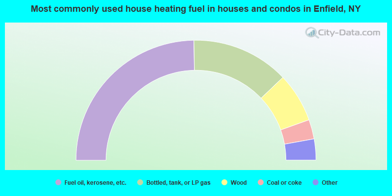
- 49.4%Fuel oil, kerosene, etc.
- 26.3%Bottled, tank, or LP gas
- 13.3%Wood
- 5.2%Coal or coke
- 3.8%Electricity
- 0.7%Solar energy
- 0.6%Utility gas
- 0.6%Other fuel
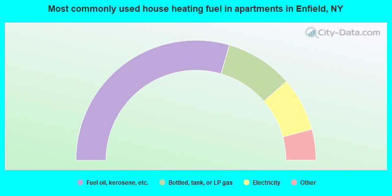
- 59.0%Fuel oil, kerosene, etc.
- 18.2%Bottled, tank, or LP gas
- 14.5%Electricity
- 3.7%Utility gas
- 2.3%Wood
- 2.3%Other fuel
Enfield compared to New York state average:
- Median house value below state average.
- Unemployed percentage below state average.
- Black race population percentage significantly below state average.
- Hispanic race population percentage significantly below state average.
- Foreign-born population percentage significantly below state average.
- Renting percentage below state average.
- Length of stay since moving in significantly above state average.
- Number of rooms per house significantly below state average.
- House age significantly below state average.