Elkhart, Iowa
Submit your own pictures of this city and show them to the world
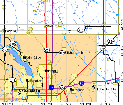
- OSM Map
- General Map
- Google Map
- MSN Map
Population change since 2000: +174.3%
| Males: 506 | |
| Females: 487 |
| Median resident age: | 40.4 years |
| Iowa median age: | 38.9 years |
Zip codes: 50073.
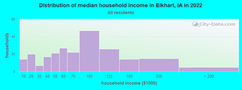
| Elkhart: | $71,965 |
| IA: | $69,588 |
Estimated per capita income in 2022: $34,989 (it was $20,397 in 2000)
Elkhart city income, earnings, and wages data
Estimated median house or condo value in 2022: $229,027 (it was $60,000 in 2000)
| Elkhart: | $229,027 |
| IA: | $194,600 |
Mean prices in 2022: all housing units: $274,515; detached houses: $287,917; townhouses or other attached units: $236,166; in 2-unit structures: $123,164; in 3-to-4-unit structures: $195,554; in 5-or-more-unit structures: $187,405; mobile homes: $57,106
(10.3% for White Non-Hispanic residents, 88.9% for Black residents, 20.0% for Hispanic or Latino residents, 12.0% for two or more races residents)
Detailed information about poverty and poor residents in Elkhart, IA
Compare current foreclosures near Elkhart, IA:
| Photo | Address | Area | Beds / Baths | Price | Details |
|---|---|---|---|---|---|

|
#1
N Grant Ave
Elkhart, IA 50073
|
976 sq. feet
|
1 baths 3 beds |
show details | |

|
#2
SE 8th St
Des Moines, IA 50315
|
1,008 sq. feet
|
1 baths 2 beds |
$224,900
|
show details |

|
#3
41st St
Des Moines, IA 50310
|
878 sq. feet
|
1 baths 2 beds |
$209,900
|
show details |

|
#4
Easton Blvd
Des Moines, IA 50317
|
824 sq. feet
|
1 baths 2 beds |
$199,500
|
show details |

|
#5
SW 36th Ln
Ankeny, IA 50023
|
1,804 sq. feet
|
3 baths 3 beds |
show details | |

|
#6
SE 8th Ct
Des Moines, IA 50315
|
1,036 sq. feet
|
2 baths 3 beds |
show details | |

|
#7
Sunset Ter
Windsor Heights, IA 50324
|
1,120 sq. feet
|
2 baths 3 beds |
show details | |

|
#8
48th Pl
Des Moines, IA 50310
|
1,246 sq. feet
|
1 baths 3 beds |
show details | |

|
#9
Walnut Dr
Des Moines, IA 50327
|
969 sq. feet
|
1 baths 3 beds |
show details | |

|
#10
Maple St
Des Moines, IA 50317
|
1,004 sq. feet
|
1 baths 3 beds |
show details |
| Photo | Address | Area | Beds / Baths | Price | Details |
|---|---|---|---|---|---|

|
#11
E 23rd St
Des Moines, IA 50317
|
829 sq. feet
|
1 baths 2 beds |
show details | |

|
#12
Chicago Ave
Des Moines, IA 50317
|
840 sq. feet
|
1 baths 3 beds |
show details | |

|
#13
Lower Beaver Rd
Des Moines, IA 50310
|
1,537 sq. feet
|
1 baths 5 beds |
show details | |

|
#14
E Washington Ave
Des Moines, IA 50317
|
850 sq. feet
|
1 baths 2 beds |
show details | |

|
#15
Cornell St
Des Moines, IA 50313
|
913 sq. feet
|
1 baths 2 beds |
show details | |

|
#16
3rd St
Des Moines, IA 50313
|
1,103 sq. feet
|
1 baths 3 beds |
show details | |

|
#17
E 19th St
Des Moines, IA 50316
|
1,322 sq. feet
|
2 baths 3 beds |
show details | |

|
#18
NE Michael Dr
Ankeny, IA 50021
|
1,312 sq. feet
|
2 baths 3 beds |
show details | |

|
#19
Kinsey Ave
Des Moines, IA 50317
|
1,002 sq. feet
|
1 baths 3 beds |
show details | |

|
#20
New York Ave
Urbandale, IA 50322
|
1,417 sq. feet
|
1 baths 3 beds |
show details |
| Photo | Address | Area | Beds / Baths | Price | Details |
|---|---|---|---|---|---|

|
#21
Oak Park Ave
Des Moines, IA 50313
|
1,017 sq. feet
|
1 baths 3 beds |
show details | |

|
#22
Arthur Ave
Des Moines, IA 50316
|
1,443 sq. feet
|
1 baths 3 beds |
show details | |

|
#23
4th St
Des Moines, IA 50313
|
832 sq. feet
|
1 baths 2 beds |
show details | |

|
#24
E 27th Ct
Des Moines, IA 50317
|
960 sq. feet
|
1 baths 2 beds |
show details | |

|
#25
E 32nd St
Des Moines, IA 50317
|
866 sq. feet
|
1 baths 2 beds |
show details | |

|
#26
E 13th St
Des Moines, IA 50316
|
1,186 sq. feet
|
1 baths 2 beds |
show details | |

|
#27
28th St
Des Moines, IA 50311
|
1,282 sq. feet
|
2 baths 2 beds |
show details | |

|
#28
Indianapolis Ave
Des Moines, IA 50317
|
1,008 sq. feet
|
1 baths 3 beds |
show details | |

|
#29
E 13th St
Des Moines, IA 50316
|
1,021 sq. feet
|
1 baths 2 beds |
show details | |

|
#30
83rd St
Urbandale, IA 50322
|
1,564 sq. feet
|
2 baths 3 beds |
show details |
| Photo | Address | Area | Beds / Baths | Price | Details |
|---|---|---|---|---|---|

|
#31
E 36th St
Des Moines, IA 50317
|
1,296 sq. feet
|
1 baths 3 beds |
show details | |

|
#32
York St
Des Moines, IA 50316
|
1,463 sq. feet
|
1 baths 3 beds |
show details | |

|
#33
Madison Ave
Des Moines, IA 50310
|
1,751 sq. feet
|
1 baths 4 beds |
show details | |

|
#34
Cornell St
Des Moines, IA 50313
|
562 sq. feet
|
1 baths 2 beds |
show details | |

|
#35
87th St
Urbandale, IA 50322
|
1,505 sq. feet
|
2 baths 2 beds |
show details | |

|
#36
12th St
Des Moines, IA 50313
|
1,166 sq. feet
|
1 baths 3 beds |
show details | |

|
#37
Hickory Ln
Urbandale, IA 50322
|
1,907 sq. feet
|
2 baths 3 beds |
show details | |

|
#38
Valdez Dr
Urbandale, IA 50322
|
1,420 sq. feet
|
1 baths 2 beds |
show details | |

|
#39
Iola Ave
Des Moines, IA 50312
|
1,270 sq. feet
|
1 baths 2 beds |
show details | |

|
#40
NW 54th Ct
Johnston, IA 50131
|
1,077 sq. feet
|
1 baths 3 beds |
show details |
| Photo | Address | Area | Beds / Baths | Price | Details |
|---|---|---|---|---|---|

|
#41
NE 53rd Ct
Des Moines, IA 50317
|
1,056 sq. feet
|
1 baths 3 beds |
show details | |

|
#42
8th Pl
Des Moines, IA 50313
|
850 sq. feet
|
1 baths 2 beds |
show details | |

|
#43
SE Glenstone Dr Unit 223
Grimes, IA 50111
|
1,712 sq. feet
|
2 baths 2 beds |
show details | |

|
#44
SE Little Beaver Dr
Grimes, IA 50111
|
1,334 sq. feet
|
1 baths 3 beds |
show details | |

|
#45
NW Torgerson Dr
Des Moines, IA 50310
|
771 sq. feet
|
1 baths 2 beds |
show details | |

|
#46
Oliver Smith Dr
Urbandale, IA 50322
|
1,200 sq. feet
|
1 baths 3 beds |
show details | |

|
#47
Wildflower Ln
Urbandale, IA 50322
|
1,527 sq. feet
|
2 baths 3 beds |
show details | |

|
#48
Richmond Ave
Des Moines, IA 50316
|
872 sq. feet
|
1 baths 2 beds |
show details | |

|
#49
SE Little Beaver Ct
Grimes, IA 50111
|
1,016 sq. feet
|
2 baths 2 beds |
show details | |

|
Check over 1 million property listings on Foreclosure.com!
|
browse all offers | |||


- 50690.2%White alone
- 173.0%Two or more races
- 162.9%Hispanic
- 91.6%Black alone
- 40.7%Other race alone
- 30.5%Asian alone
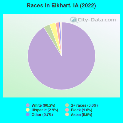
Races in Elkhart detailed stats: ancestries, foreign born residents, place of birth
According to our research of Iowa and other state lists, there was 1 registered sex offender living in Elkhart, Iowa as of May 22, 2024.
The ratio of all residents to sex offenders in Elkhart is 841 to 1.
The ratio of registered sex offenders to all residents in this city is lower than the state average.
 Recent articles from our blog. Our writers, many of them Ph.D. graduates or candidates, create easy-to-read articles on a wide variety of topics.


 | I love Des Moines! (25 replies) |
| mobile home/manufactured communities (2 replies) |
| Is there any manufacturing in Des Moines? (31 replies) |
| Des Moines suburbs and schools (24 replies) |
Latest news from Elkhart, IA collected exclusively by city-data.com from local newspapers, TV, and radio stations
Ancestries: German (32.1%), Irish (10.0%), Norwegian (8.8%), Swedish (8.8%), American (6.8%), French (3.6%).
Current Local Time: CST time zone
Incorporated on 07/27/1904
Elevation: 788 feet
Land area: 1.18 square miles.
Population density: 840 people per square mile (low).
6 residents are foreign born
| This city: | 1.1% |
| Iowa: | 5.6% |
| Elkhart city: | 1.5% ($926) |
| Iowa: | 1.3% ($1,077) |
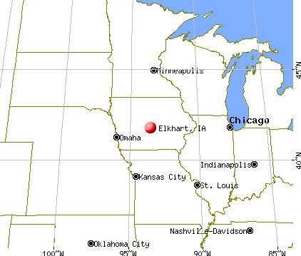
Nearest city with pop. 50,000+: Des Moines, IA  (14.8 miles , pop. 198,682).
Nearest city with pop. 200,000+: Omaha, NE (134.0 miles , pop. 390,007).
Nearest city with pop. 1,000,000+: Chicago, IL (301.3 miles , pop. 2,896,016).
Nearest cities:
), ), ), ), Latitude: 41.79 N, Longitude: 93.52 W
Area code: 515
Property values in Elkhart, IA

Single-family new house construction building permits:
- 2022: 10 buildings, average cost: $295,000
- 2021: 34 buildings, average cost: $225,400
- 2020: 20 buildings, average cost: $270,000
- 2019: 20 buildings, average cost: $240,000
- 2018: 32 buildings, average cost: $203,600
- 2017: 22 buildings, average cost: $194,800
- 2016: 8 buildings, average cost: $282,000
- 2015: 11 buildings, average cost: $219,700
- 2014: 10 buildings, average cost: $221,800
- 2013: 9 buildings, average cost: $221,800
- 2012: 3 buildings, average cost: $527,300
- 2011: 3 buildings, average cost: $527,300
- 2005: 1 building, cost: $101,300
- 1999: 1 building, cost: $260,000
- 1998: 1 building, cost: $63,600
| Here: | 2.6% |
| Iowa: | 2.7% |
- Construction (14.7%)
- Health care (10.4%)
- Finance & insurance (7.4%)
- Social assistance (6.1%)
- Public administration (6.1%)
- Educational services (4.9%)
- Administrative & support & waste management services (4.9%)
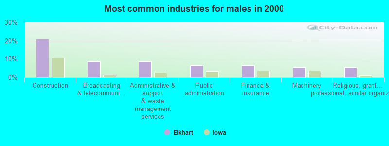
- Construction (20.9%)
- Broadcasting & telecommunications (8.8%)
- Administrative & support & waste management services (8.8%)
- Public administration (6.6%)
- Finance & insurance (6.6%)
- Machinery (5.5%)
- Religious, grantmaking, civic, professional, similar organizations (5.5%)
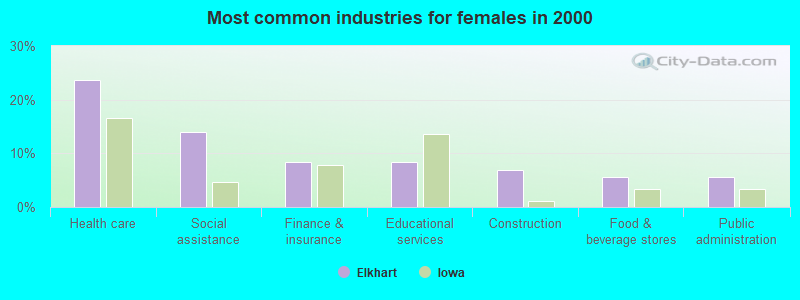
- Health care (23.6%)
- Social assistance (13.9%)
- Finance & insurance (8.3%)
- Educational services (8.3%)
- Construction (6.9%)
- Food & beverage stores (5.6%)
- Public administration (5.6%)
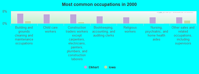
- Building and grounds cleaning and maintenance occupations (6.7%)
- Child care workers (6.1%)
- Construction traders workers except carpenters, electricians, painters, plumbers, and construction laborers (6.1%)
- Bookkeeping, accounting, and auditing clerks (4.9%)
- Religious workers (4.3%)
- Nursing, psychiatric, and home health aides (4.3%)
- Other sales and related occupations, including supervisors (4.3%)
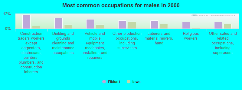
- Construction traders workers except carpenters, electricians, painters, plumbers, and construction laborers (11.0%)
- Building and grounds cleaning and maintenance occupations (8.8%)
- Vehicle and mobile equipment mechanics, installers, and repairers (7.7%)
- Other production occupations, including supervisors (6.6%)
- Laborers and material movers, hand (6.6%)
- Religious workers (5.5%)
- Other sales and related occupations, including supervisors (5.5%)
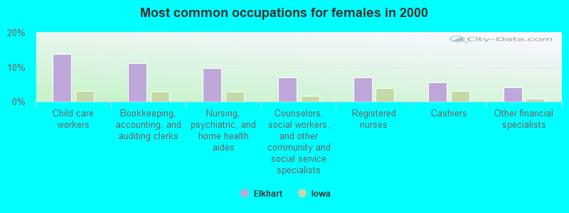
- Child care workers (13.9%)
- Bookkeeping, accounting, and auditing clerks (11.1%)
- Nursing, psychiatric, and home health aides (9.7%)
- Counselors, social workers, and other community and social service specialists (6.9%)
- Registered nurses (6.9%)
- Cashiers (5.6%)
- Other financial specialists (4.2%)
Average climate in Elkhart, Iowa
Based on data reported by over 4,000 weather stations


(lower is better)
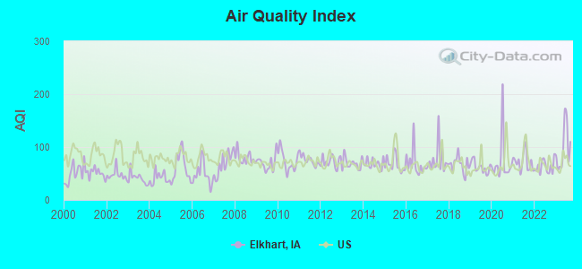
Air Quality Index (AQI) level in 2023 was 97.4. This is worse than average.
| City: | 97.4 |
| U.S.: | 72.6 |
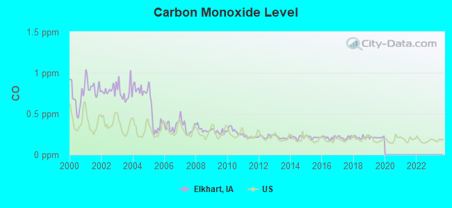
Carbon Monoxide (CO) [ppm] level in 2019 was 0.209. This is better than average. Closest monitor was 10.0 miles away from the city center.
| City: | 0.209 |
| U.S.: | 0.251 |
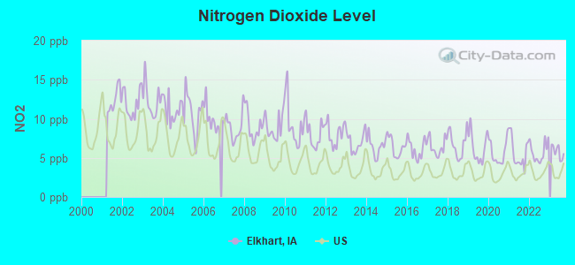
Nitrogen Dioxide (NO2) [ppb] level in 2023 was 5.78. This is about average. Closest monitor was 13.0 miles away from the city center.
| City: | 5.78 |
| U.S.: | 5.11 |
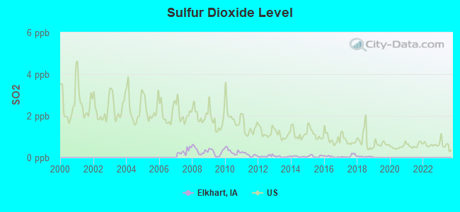
Sulfur Dioxide (SO2) [ppb] level in 2018 was 0.0417. This is significantly better than average. Closest monitor was 12.8 miles away from the city center.
| City: | 0.0417 |
| U.S.: | 1.5147 |
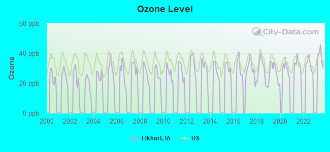
Ozone [ppb] level in 2023 was 36.8. This is about average. Closest monitor was 7.1 miles away from the city center.
| City: | 36.8 |
| U.S.: | 33.3 |
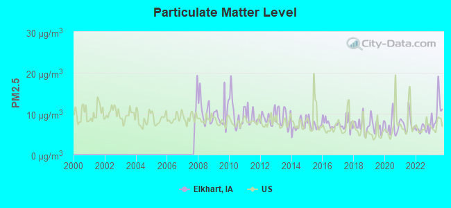
Particulate Matter (PM2.5) [µg/m3] level in 2023 was 10.8. This is worse than average. Closest monitor was 9.5 miles away from the city center.
| City: | 10.8 |
| U.S.: | 8.1 |
Tornado activity:
Elkhart-area historical tornado activity is slightly above Iowa state average. It is 112% greater than the overall U.S. average.
On 6/13/1976, a category F5 (max. wind speeds 261-318 mph) tornado 20.1 miles away from the Elkhart city center injured 9 people and caused between $5,000,000 and $50,000,000 in damages.
On 9/28/1986, a category F4 (max. wind speeds 207-260 mph) tornado 4.9 miles away from the city center caused between $500,000 and $5,000,000 in damages.
Earthquake activity:
Elkhart-area historical earthquake activity is significantly above Iowa state average. It is 202% greater than the overall U.S. average.On 9/3/2016 at 12:02:44, a magnitude 5.8 (5.8 MW, Depth: 3.5 mi, Class: Moderate, Intensity: VI - VII) earthquake occurred 413.7 miles away from Elkhart center
On 4/18/2008 at 09:36:59, a magnitude 5.4 (5.1 MB, 4.8 MS, 5.4 MW, 5.2 MW) earthquake occurred 377.1 miles away from Elkhart center
On 4/18/2008 at 09:36:59, a magnitude 5.2 (5.2 MW, Depth: 8.9 mi) earthquake occurred 377.2 miles away from the city center
On 6/10/1987 at 23:48:54, a magnitude 5.1 (4.9 MB, 4.4 MS, 4.6 MS, 5.1 LG) earthquake occurred 361.5 miles away from the city center
On 11/6/2011 at 03:53:10, a magnitude 5.7 (5.7 MW, Depth: 3.2 mi) earthquake occurred 467.0 miles away from the city center
On 7/9/1975 at 14:54:15, a magnitude 4.6 (4.6 MB, Class: Light, Intensity: IV - V) earthquake occurred 296.1 miles away from the city center
Magnitude types: regional Lg-wave magnitude (LG), body-wave magnitude (MB), surface-wave magnitude (MS), moment magnitude (MW)
Natural disasters:
The number of natural disasters in Polk County (17) is near the US average (15).Major Disasters (Presidential) Declared: 13
Emergencies Declared: 1
Causes of natural disasters: Floods: 12, Storms: 10, Tornadoes: 5, Heavy Rain: 1, Hurricane: 1, Snow: 1, Wind: 1, Winter Storm: 1, Other: 1 (Note: some incidents may be assigned to more than one category).
Hospitals and medical centers near Elkhart:
- MILL-POND RETIREMENT COMMUNITY (Nursing Home, about 6 miles away; ANKENY, IA)
- ON WITH LIFE (Nursing Home, about 8 miles away; ANKENY, IA)
- POLK CITY NURSING AND REHABILITATION CENTER (Nursing Home, about 11 miles away; POLK CITY, IA)
- EASTON HEALTH CENTER (Nursing Home, about 13 miles away; DES MOINES, IA)
- TRINITY CENTER AT LUTHER PARK (Nursing Home, about 13 miles away; DES MOINES, IA)
- QHC MITCHELLVILLE, LLC (Nursing Home, about 13 miles away; MITCHELLVILLE, IA)
- VALLEY VIEW VILLAGE (Nursing Home, about 13 miles away; DES MOINES, IA)
Colleges/universities with over 2000 students nearest to Elkhart:
- Des Moines Area Community College (about 8 miles; Ankeny, IA; Full-time enrollment: 15,337)
- Drake University (about 15 miles; Des Moines, IA; FT enrollment: 3,768)
- Iowa State University (about 18 miles; Ames, IA; FT enrollment: 28,662)
- Iowa Central Community College (about 60 miles; Fort Dodge, IA; FT enrollment: 4,682)
- University of Northern Iowa (about 75 miles; Cedar Falls, IA; FT enrollment: 10,816)
- Hawkeye Community College (about 76 miles; Waterloo, IA; FT enrollment: 7,160)
- Indian Hills Community College (about 79 miles; Ottumwa, IA; FT enrollment: 4,034)
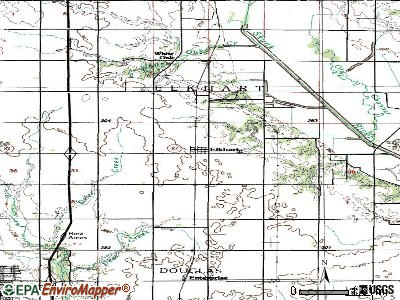
Points of interest:
Notable locations in Elkhart: Elkhart (A), Elkhart City Hall (B), Elkhart Fire Department (C). Display/hide their locations on the map
Churches in Elkhart include: Faith Christian Fellowship (A), Christian Church (B), Saint Mary's Catholic Church (C). Display/hide their locations on the map
Cemetery: Elkhart Cemetery (1). Display/hide its location on the map
Tourist attraction: Lake Ahquabi Campground (Amusement & Theme Parks; 15792 118th Avenue).
| This city: | 2.7 people |
| Iowa: | 2.4 people |
| This city: | 68.4% |
| Whole state: | 64.7% |
| This city: | 7.4% |
| Whole state: | 6.7% |
Likely homosexual households (counted as self-reported same-sex unmarried-partner households)
- Lesbian couples: 1.2% of all households
- Gay men: 0.0% of all households
For population 15 years and over in Elkhart:
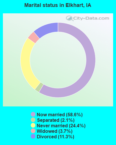
- Never married: 24.4%
- Now married: 58.6%
- Separated: 2.1%
- Widowed: 3.7%
- Divorced: 11.3%
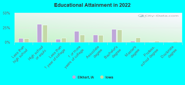
For population 25 years and over in Elkhart:
- High school or higher: 92.9%
- Bachelor's degree or higher: 24.0%
- Graduate or professional degree: 3.0%
- Unemployed: 3.6%
- Mean travel time to work (commute): 29.3 minutes
| Here: | 8.1 |
| Iowa average: | 10.5 |
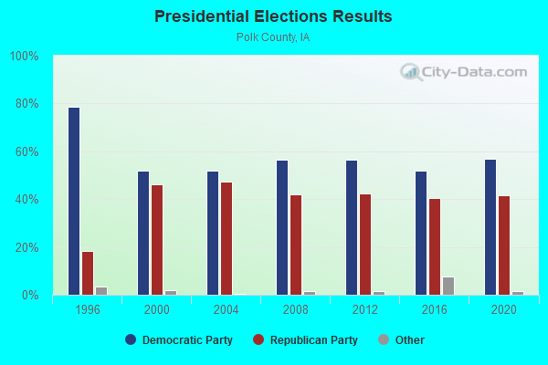
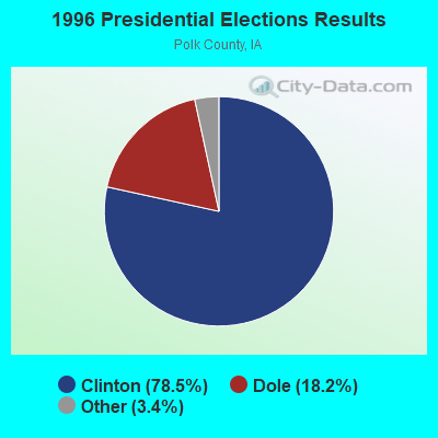
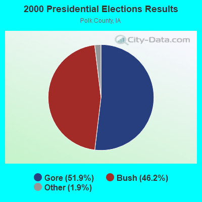
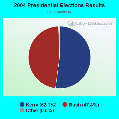

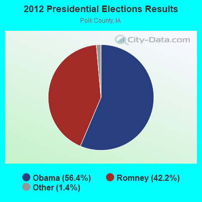

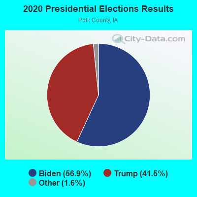
Graphs represent county-level data. Detailed 2008 Election Results
Religion statistics for Elkhart, IA (based on Polk County data)
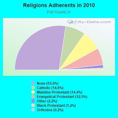
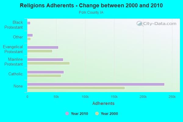
| Religion | Adherents | Congregations |
|---|---|---|
| Catholic | 62,867 | 19 |
| Mainline Protestant | 61,821 | 117 |
| Evangelical Protestant | 53,822 | 208 |
| Other | 9,331 | 35 |
| Black Protestant | 5,275 | 19 |
| Orthodox | 646 | 4 |
| None | 236,878 | - |
Food Environment Statistics:
| Polk County: | 1.51 / 10,000 pop. |
| Iowa: | 2.14 / 10,000 pop. |
| Here: | 0.17 / 10,000 pop. |
| Iowa: | 0.23 / 10,000 pop. |
| Polk County: | 0.19 / 10,000 pop. |
| Iowa: | 0.43 / 10,000 pop. |
| Polk County: | 3.78 / 10,000 pop. |
| Iowa: | 5.55 / 10,000 pop. |
| Here: | 7.57 / 10,000 pop. |
| Iowa: | 8.01 / 10,000 pop. |
| This county: | 7.3% |
| Iowa: | 7.8% |
| This county: | 25.8% |
| State: | 27.3% |
| Polk County: | 13.5% |
| State: | 14.5% |
Health and Nutrition:
| Here: | 48.5% |
| Iowa: | 49.5% |
| This city: | 45.5% |
| Iowa: | 46.1% |
| Elkhart: | 28.7 |
| Iowa: | 28.6 |
| Elkhart: | 22.9% |
| Iowa: | 21.4% |
| Here: | 11.2% |
| State: | 10.4% |
| Elkhart: | 6.9 |
| Iowa: | 6.8 |
| This city: | 31.3% |
| State: | 33.8% |
| This city: | 55.6% |
| Iowa: | 55.9% |
| Here: | 77.1% |
| State: | 77.7% |
More about Health and Nutrition of Elkhart, IA Residents
| Local government employment and payroll (March 2022) | |||||
| Function | Full-time employees | Monthly full-time payroll | Average yearly full-time wage | Part-time employees | Monthly part-time payroll |
|---|---|---|---|---|---|
| Other Government Administration | 1 | $4,296 | $51,552 | 5 | $1,041 |
| Financial Administration | 0 | $0 | 5 | $6,386 | |
| Parks and Recreation | 0 | $0 | 3 | $2,660 | |
| Other and Unallocable | 0 | $0 | 3 | $250 | |
| Totals for Government | 1 | $4,296 | $51,552 | 16 | $10,337 |
Elkhart government finances - Expenditure in 2017 (per resident):
- Construction - General - Other: $110,000 ($110.78)
- Current Operations - Water Utilities: $106,000 ($106.75)
Local Fire Protection: $63,000 ($63.44)
Sewerage: $60,000 ($60.42)
General - Other: $35,000 ($35.25)
Central Staff Services: $29,000 ($29.20)
Parks and Recreation: $24,000 ($24.17)
Solid Waste Management: $23,000 ($23.16)
General Public Buildings: $22,000 ($22.16)
Regular Highways: $16,000 ($16.11)
Financial Administration: $16,000 ($16.11)
Protective Inspection and Regulation - Other: $13,000 ($13.09)
Police Protection: $12,000 ($12.08)
Health - Other: $11,000 ($11.08)
Miscellaneous Commercial Activities - Other: $6,000 ($6.04)
Libraries: $4,000 ($4.03)
Judicial and Legal Services: $4,000 ($4.03)
- General - Interest on Debt: $13,000 ($13.09)
- Intergovernmental to Local - Other - General - Other: $13,000 ($13.09)
Other - Police Protection: $12,000 ($12.08)
Other - Libraries: $4,000 ($4.03)
- Total Salaries and Wages: $83,000 ($83.59)
- Water Utilities - Interest on Debt: $9,000 ($9.06)
Elkhart government finances - Revenue in 2017 (per resident):
- Charges - Sewerage: $91,000 ($91.64)
Solid Waste Management: $8,000 ($8.06)
- Federal Intergovernmental - General Local Government Support: $5,000 ($5.04)
- Local Intergovernmental - Other: $62,000 ($62.44)
- Miscellaneous - General Revenue - Other: $29,000 ($29.20)
Donations From Private Sources: $21,000 ($21.15)
Interest Earnings: $5,000 ($5.04)
Sale of Property: $1,000 ($1.01)
- Revenue - Water Utilities: $95,000 ($95.67)
Electric Utilities: $12,000 ($12.08)
- State Intergovernmental - Highways: $44,000 ($44.31)
- Tax - Property: $229,000 ($230.61)
Other License: $28,000 ($28.20)
Public Utilities Sales: $6,000 ($6.04)
Other Selective Sales: $1,000 ($1.01)
Elkhart government finances - Debt in 2017 (per resident):
- Long Term Debt - Beginning Outstanding - Unspecified Public Purpose: $728,000 ($733.13)
Outstanding Unspecified Public Purpose: $627,000 ($631.42)
Retired Unspecified Public Purpose: $101,000 ($101.71)
Elkhart government finances - Cash and Securities in 2017 (per resident):
- Other Funds - Cash and Securities: $1,111,000 ($1118.83)
Strongest AM radio stations in Elkhart:
- WHO (1040 AM; 50 kW; DES MOINES, IA; Owner: CITICASTERS LICENSES, L.P.)
- KXNO (1460 AM; 5 kW; DES MOINES, IA; Owner: CAPSTAR TX LIMITED PARTNERSHIP)
- KBGG (1700 AM; 10 kW; DES MOINES, IA; Owner: CITADEL BROADCASTING COMPANY)
- WOI (640 AM; 5 kW; AMES, IA; Owner: IOWA STATE UNIV., OF SCIENCE & TECH.)
- KPSZ (940 AM; 10 kW; DES MOINES, IA; Owner: SAGA COMMUNICATIONS OF IOWA, LLC)
- KRNT (1350 AM; 5 kW; DES MOINES, IA; Owner: SAGA COMMUNICATIONS OF IOWA, LLC)
- KXEL (1540 AM; 50 kW; WATERLOO, IA; Owner: KXEL BROADCASTING COMPANY, INC.)
- KFGQ (1260 AM; 5 kW; BOONE, IA; Owner: BOONE BIBLICAL MINISTRIES, INC.)
- KOIL (1020 AM; 50 kW; PLATTSMOUTH, NE; Owner: WAITT RADIO, INC.)
- KFAB (1110 AM; 50 kW; OMAHA, NE; Owner: CAPSTAR TX LIMITED PARTNERSHIP)
- KWMT (540 AM; 5 kW; FORT DODGE, IA; Owner: CLEAR CHANNEL BROADCASTING LICENSES, INC.)
- KKAR (1290 AM; 50 kW; OMAHA, NE; Owner: WAITT RADIO, INC.)
- KASI (1430 AM; 1 kW; AMES, IA)
Strongest FM radio stations in Elkhart:
- KMXD (100.3 FM; DES MOINES, IA; Owner: CITICASTERS LICENSES, L.P.)
- WOI-FM (90.1 FM; AMES, IA; Owner: IOWA STATE UNIVERSITY OF SCI & TECH)
- KSTZ (102.5 FM; DES MOINES, IA; Owner: SAGA COMMUNICATIONS OF IOWA, LLC)
- KGGO (94.9 FM; DES MOINES, IA; Owner: CITADEL BROADCASTING COMPANY)
- KAZR (103.3 FM; PELLA, IA; Owner: SAGA COMMUNICATIONS OF IOWA, LLC)
- KIOA (93.3 FM; DES MOINES, IA; Owner: SAGA COMMUNICATIONS OF IOWA, LLC)
- KRKQ (98.3 FM; BOONE, IA; Owner: CITADEL BROADCASTING COMPANY)
- KVJZ (106.3 FM; ANKENY, IA; Owner: CITICASTERS LICENSES, L.P.)
- KKDM (107.5 FM; DES MOINES, IA; Owner: CLEAR CHANNEL BROADCASTING LICENSES, INC.)
- KLTI-FM (104.1 FM; AMES, IA; Owner: SAGA COMMUNICATIONS OF IOWA, LLC)
- KDFR (91.3 FM; DES MOINES, IA; Owner: FAMILY STATIONS, INC.)
- KJJY (92.5 FM; WEST DES MOINES, IA; Owner: CITADEL BROADCASTING COMPANY)
- KHKI (97.3 FM; DES MOINES, IA; Owner: CITADEL BROADCASTING COMPANY)
- KLRX (96.1 FM; MADRID, IA; Owner: THOMAS H. BURKE, RECEIVER FOR LIFESTYLE COMMUNICATIONS CORP.)
- KJMC (89.3 FM; DES MOINES, IA; Owner: MINORITY COMMUNICATIONS, INC.)
- KCCQ (105.1 FM; AMES, IA; Owner: CITICASTERS LICENSES, L.P.)
- K269EJ (101.7 FM; DES MOINES, IA; Owner: UNIVERSITY OF NORTHERN IOWA)
- KXIA (101.1 FM; MARSHALLTOWN, IA; Owner: MARSHALLTOWN BROADCASTING, INC.)
- KFGQ-FM (99.3 FM; BOONE, IA; Owner: BOONE BIBLICAL MINISTRIES, INC.)
- KCOB-FM (95.9 FM; NEWTON, IA; Owner: CENTRAL IOWA BROADCASTING, INC.)
TV broadcast stations around Elkhart:
- WOI-TV (Channel 5; AMES, IA; Owner: CAPITAL COMMUNICATIONS COMPANY, INC.)
- KDSM-TV (Channel 17; DES MOINES, IA; Owner: KDSM LICENSEE, LLC)
- KDIN-TV (Channel 11; DES MOINES, IA; Owner: IOWA PUBLIC BROADCASTING BOARD)
- KPWB-TV (Channel 23; AMES, IA; Owner: PAPPAS TELECASTING OF IOWA, L.L.C.)
- KCCI (Channel 8; DES MOINES, IA; Owner: DES MOINES HEARST-ARGYLE TV, INC.)
- WHO-TV (Channel 13; DES MOINES, IA; Owner: NEW YORK TIMES MANAGEMENT SERVICES)
- WBXF-CA (Channel 4; DES MOINES, IA; Owner: THE BOX WORLDWIDE LLC)
- KRPG-LP (Channel 43; DES MOINES, IA; Owner: TIGER EYE BROADCASTING CORPORATION)
- K41DD (Channel 41; DES MOINES, IA; Owner: VENTANA TELEVISION, INC.)
- K29EA (Channel 29; DES MOINES, IA; Owner: TV-45, INC.)
- KFPX (Channel 39; NEWTON, IA; Owner: PAXSON DES MOINES LICENSE, INC.)
- K48FZ (Channel 48; AMES, IA; Owner: TV-52, INC.)
- K56GD (Channel 56; AMES, IA; Owner: TV-45, INC.)
- K46EY (Channel 46; DES MOINES, IA; Owner: TV-45, INC.)
Elkhart fatal accident list:
- National Bridge Inventory (NBI) Statistics
- 16Number of bridges
- 135ft / 40.6mTotal length
- 7,435Total average daily traffic
- 802Total average daily truck traffic
- 7,435Total future (year 2040) average daily traffic
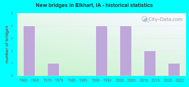
- New bridges - historical statistics
- 41960-1969
- 11970-1979
- 41990-1999
- 42000-2009
- 22010-2019
- 12020-2022
FCC Registered Cell Phone Towers:
1 (See the full list of FCC Registered Cell Phone Towers in Elkhart)FCC Registered Antenna Towers:
34 (See the full list of FCC Registered Antenna Towers)FCC Registered Broadcast Land Mobile Towers:
2- 13202 Ne 56th St (Lat: 41.802500 Lon: -93.504194), Call Sign: WQRS985,
Assigned Frequencies: 158.355 MHz, Grant Date: 06/29/2023, Expiration Date: 07/22/2033, Certifier: Matthew Owen, Registrant: Electronic Engineering Co, 1100 Keo Way, Des Moines, IA 50309, Phone: (515) 283-1100, Fax: (515) 283-1200, Email:
- ELKHART, 12668 Ne 29th St. (Lat: 41.791806 Lon: -93.561417), Type: Ltower, Structure height: 59.4 m, Overall height: 60.7 m, Call Sign: WRMI930,
Assigned Frequencies: 769.293 MHz, 770.043 MHz, 770.793 MHz, 771.618 MHz, 772.443 MHz, 773.168 MHz, 774.168 MHz, 774.918 MHz, Grant Date: 04/16/2021, Expiration Date: 04/16/2031, Certifier: Brent Long, Registrant: Racom Corp., 201 W. State St., Marshalltown, IA 50158, Phone: (888) 752-1016, Email:
FCC Registered Microwave Towers:
7- ELKHART IA MW, 462 Nw Main Street (Lat: 41.793639 Lon: -93.526778), Type: Ltower, Structure height: 51.8 m, Call Sign: WNEG465,
Assigned Frequencies: 6256.54 MHz, 6725.00 MHz, 6256.54 MHz, 6725.00 MHz, 6256.54 MHz, 6725.00 MHz, 6256.54 MHz, 6725.00 MHz, 6256.54 MHz, 6256.54 MHz, 6256.54 MHz, Grant Date: 12/13/2019, Expiration Date: 01/25/2030, Registrant: Prokarma, 222 So 15th St. Suite 505n, Omaha, NE 68102, Phone: (402) 522-5068, Fax: (402) 346-6676, Email:
- 1162 STALL, 2241 Ne 142nd Ave (Lat: 41.820528 Lon: -93.571306), Type: Tower, Structure height: 42.7 m, Overall height: 45.7 m, Call Sign: WPNH335,
Assigned Frequencies: 6635.00 MHz, 6595.00 MHz, Grant Date: 02/27/2001, Expiration Date: 02/01/2011, Cancellation Date: 10/12/2007, Certifier: Dan Menser, Registrant: T-Mobile License LLC, 12920 Se 38th St, Bellevue, WA 98006, Phone: (425) 378-4000, Email:
- ELKHART, 100' N Of Main St (Lat: 41.793306 Lon: -93.526861), Structure height: 51.8 m, Call Sign: WPOR837,
Assigned Frequencies: 928.331 MHz, 952.331 MHz, Grant Date: 12/21/2018, Expiration Date: 01/25/2029, Cancellation Date: 11/04/2022, Registrant: Prokarma, 222 So 15th St., Suite 505n, Omaha, NE 68102, Phone: (402) 522-5068, Fax: (402) 346-6676, Email:
- ALLEMAN, 2521 Ne 142nd St (Lat: 41.819944 Lon: -93.571833), Type: Gtower, Structure height: 76.2 m, Overall height: 80.7 m, Call Sign: WPWF374,
Assigned Frequencies: 11285.0 MHz, Grant Date: 10/04/2022, Expiration Date: 11/04/2032, Certifier: Steven T Campbell, Registrant: Wilkinson Barker Knauer, LLP, 1800 M Street Nw, Suite 800n, Washington, DC 20036, Phone: (202) 383-3420, Fax: (202) 783-5851, Email:
- Volz, 126th Ave. & 29th St. (Volz# 50822) (Lat: 41.792250 Lon: -93.559361), Type: Tower, Structure height: 91.4 m, Overall height: 94.2 m, Call Sign: WQIZ801,
Assigned Frequencies: 10755.0 MHz, Grant Date: 06/30/2008, Expiration Date: 06/30/2018, Cancellation Date: 12/30/2009, Certifier: William Chastain, Registrant: Radio Dynamics Corporation, Silver Spring, MD 20914, Phone: (301) 493-5171, Fax: (301) 576-4553, Email:
- DM01162STALL, 2241 Ne 142nd Avenue (Lat: 41.820833 Lon: -93.571111), Type: Mtower, Structure height: 45.7 m, Call Sign: WQXJ378,
Assigned Frequencies: 11385.0 MHz, 11425.0 MHz, 11385.0 MHz, 11425.0 MHz, 11385.0 MHz, 11425.0 MHz, 11385.0 MHz, 11425.0 MHz, 11385.0 MHz, 11425.0 MHz... (+6 more), Grant Date: 03/22/2016, Expiration Date: 03/22/2026, Cancellation Date: 03/02/2020, Certifier: David Werblow, Registrant: Dla Piper LLP, 500 8th St Nw, Washington, DC 20004, Phone: (202) 799-4216, Email:
- Elkhart, 12668 Ne 29th St. (Lat: 41.791806 Lon: -93.561417), Type: Ltower, Structure height: 59.4 m, Overall height: 60.7 m, Call Sign: WRME573, Licensee ID: L00007964,
Assigned Frequencies: 6123.10 MHz, 6063.80 MHz, 6123.10 MHz, 6063.80 MHz, 6123.10 MHz, 6063.80 MHz, 6123.10 MHz, 6063.80 MHz, 6123.10 MHz, 6063.80 MHz... (+3 more), Grant Date: 03/29/2021, Expiration Date: 03/29/2031, Certifier: Carrie Loney, Registrant: Racom Corporation, 201 W. State St., Marshalltown, IA 50158, Phone: (888) 752-1016, Email:
FCC Registered Amateur Radio Licenses:
8 (See the full list of FCC Registered Amateur Radio Licenses in Elkhart)FAA Registered Aircraft:
6- Aircraft: PEARSON RICHARD L RV 10 (Category: Land, Seats: 4, Weight: Up to 12,499 Pounds), Engine: LYCOMING IO-540-C4B5 (250 HP) (4 Cycle)
N-Number: 1WG, N1WG, N-1WG, Serial Number: 40697, Year manufactured: 2009, Airworthiness Date: 04/14/2009, Certificate Issue Date: 05/12/2016
Registrant (LLC): Gard Aviation LLC, Po Box 102, Elkhart, IA 50073 - Aircraft: MOONEY M20J (Category: Land, Seats: 4, Weight: Up to 12,499 Pounds, Speed: 126 mph), Engine: Reciprocating
N-Number: 201PL, N201PL, N-201PL, Serial Number: 24-0284, Year manufactured: 1977, Airworthiness Date: 09/16/1977, Certificate Issue Date: 09/30/2004
Registrant (Individual): Paul Reinke, 5750 Ne 118th Ave, Elkhart, IA 50073 - Aircraft: AERONCA 65-C (Category: Land, Seats: 2, Weight: Up to 12,499 Pounds, Speed: 75 mph), Engine: CONT MOTOR A&C65 SERIES (65 HP) (Reciprocating)
N-Number: 21378, N21378, N-21378, Serial Number: C-1878, Year manufactured: 1938, Airworthiness Date: 01/05/1956, Certificate Issue Date: 01/11/2012
Registrant (Individual): Paul A Reinke, 5750 Ne 118th Ave, Elkhart, IA 50073 - Aircraft: CESSNA 182G (Category: Land, Seats: 4, Weight: Up to 12,499 Pounds, Speed: 119 mph), Engine: CONT MOTOR O-470 SERIES (230 HP) (Reciprocating)
N-Number: 2476R, N2476R, N-2476R, Serial Number: 18255576, Year manufactured: 1964, Airworthiness Date: 05/29/2003, Certificate Issue Date: 06/05/2014
Registrant (Co-Owned): Richard J Trustee Bascom, 14409 Ne 46th St, Elkhart, IA 50073, Other Owners: Diane K Trustee Bascom - Aircraft: CESSNA 140 (Category: Land, Seats: 2, Weight: Up to 12,499 Pounds, Speed: 105 mph), Engine: CONT MOTOR C85 SERIES (85 HP) (Reciprocating)
N-Number: 4188N, N4188N, N-4188N, Serial Number: 13659, Year manufactured: 1947, Airworthiness Date: 12/20/1955, Certificate Issue Date: 06/04/2014
Registrant (Co-Owned): Richard J Trustee Bascom, 14409 Ne 46th St, Elkhart, IA 50073, Other Owners: Diane K Trustee Bascom - Aircraft: PEARSON RICHARD L RV 10 (Category: Land, Seats: 4, Weight: Up to 12,499 Pounds), Engine: LYCOMING IO-540-C4B5 (250 HP) (4 Cycle)
N-Number: 527RP, N527RP, N-527RP, Serial Number: 40697, Year manufactured: 2009, Airworthiness Date: 04/14/2009
Registrant (Individual): Pending Registration, Po Box 102, Elkhart, IA 50073
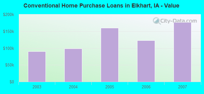
| Home Mortgage Disclosure Act Aggregated Statistics For Year 2009 (Based on 1 partial tract) | ||
| C) Refinancings | ||
|---|---|---|
| Number | Average Value | |
| LOANS ORIGINATED | 2 | $173,895 |
| APPLICATIONS APPROVED, NOT ACCEPTED | 0 | $0 |
| APPLICATIONS DENIED | 0 | $0 |
| APPLICATIONS WITHDRAWN | 0 | $0 |
| FILES CLOSED FOR INCOMPLETENESS | 0 | $0 |
Detailed HMDA statistics for the following Tracts: 0101.01
2002 - 2018 National Fire Incident Reporting System (NFIRS) incidents
- Fire incident types reported to NFIRS in Elkhart, IA
- 11352.1%Outside Fires
- 4018.4%Structure Fires
- 3616.6%Mobile Property/Vehicle Fires
- 2812.9%Other
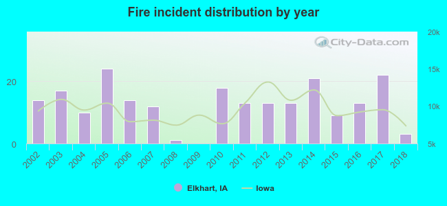 Based on the data from the years 2002 - 2018 the average number of fire incidents per year is 13. The highest number of fires - 24 took place in 2005, and the least - 0 in 2009. The data has a declining trend.
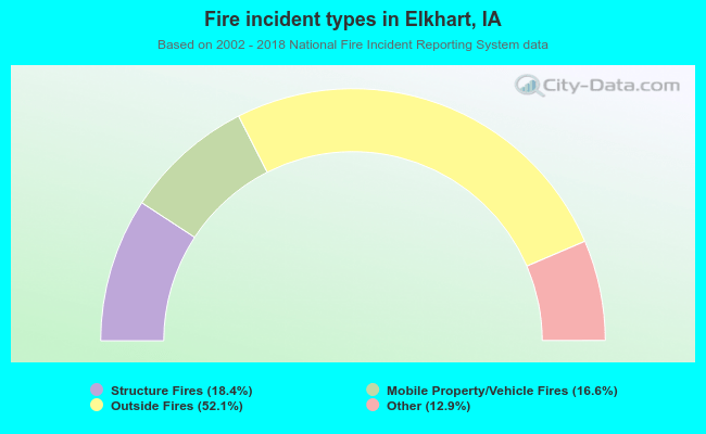 When looking into fire subcategories, the most reports belonged to: Outside Fires (52.1%), and Structure Fires (18.4%).
| Most common first names in Elkhart, IA among deceased individuals | ||
| Name | Count | Lived (average) |
|---|---|---|
| Mary | 8 | 82.0 years |
| George | 6 | 75.3 years |
| Harold | 5 | 72.0 years |
| James | 5 | 75.4 years |
| John | 5 | 76.0 years |
| Ralph | 5 | 84.6 years |
| Henry | 4 | 80.0 years |
| Arthur | 4 | 81.5 years |
| Dorothy | 4 | 80.0 years |
| William | 3 | 75.0 years |
| Most common last names in Elkhart, IA among deceased individuals | ||
| Last name | Count | Lived (average) |
|---|---|---|
| Cory | 9 | 72.1 years |
| Albaugh | 7 | 75.6 years |
| Herman | 6 | 73.0 years |
| Wilson | 6 | 86.0 years |
| Ault | 5 | 73.4 years |
| Hall | 5 | 76.6 years |
| Spooner | 4 | 83.5 years |
| Law | 4 | 88.3 years |
| Owen | 4 | 78.5 years |
| Fontana | 3 | 77.0 years |
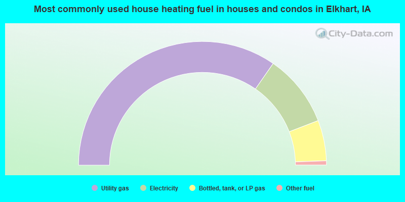
- 69.3%Utility gas
- 19.0%Electricity
- 10.6%Bottled, tank, or LP gas
- 1.1%Other fuel
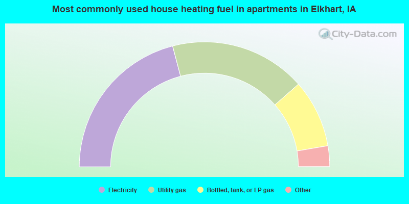
- 44.2%Electricity
- 37.2%Utility gas
- 18.6%Bottled, tank, or LP gas
Elkhart compared to Iowa state average:
- Unemployed percentage significantly below state average.
- Median age significantly below state average.
- Foreign-born population percentage significantly below state average.
- Length of stay since moving in significantly below state average.
- House age significantly below state average.

|
Total of 13 patent applications in 2008-2024.