Elder, Georgia
Submit your own pictures of this place and show them to the world
- OSM Map
- General Map
- Google Map
- MSN Map

| Males: 1,101 | |
| Females: 1,099 |
| Median resident age: | 37.0 years |
| Georgia median age: | 33.4 years |
Zip code: 30677
| Elder: | $104,752 |
| GA: | $72,837 |
Estimated per capita income in 2022: $49,357 (it was $21,826 in 2000)
Elder CCD income, earnings, and wages data
Estimated median house or condo value in 2022: $453,290 (it was $140,500 in 2000)
| Elder: | $453,290 |
| GA: | $297,400 |
Mean prices in 2022: all housing units: $484,571; detached houses: $502,111; townhouses or other attached units: $256,030; in 2-unit structures: $138,521; mobile homes: $98,971
Detailed information about poverty and poor residents in Elder, GA


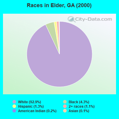
- 1,71092.9%White alone
- 804.3%Black alone
- 241.3%Hispanic
- 211.1%Two or more races
- 40.2%American Indian alone
- 20.1%Asian alone
Races in Elder detailed stats: ancestries, foreign born residents, place of birth
 Recent articles from our blog. Our writers, many of them Ph.D. graduates or candidates, create easy-to-read articles on a wide variety of topics.
Current Local Time: EST time zone
Elevation: 620 feet
Land area: 47.7 square miles.
Population density: 46 people per square mile (very low).

| Elder CCD: | 0.8% ($1,163) |
| Georgia: | 0.9% ($919) |
Nearest city with pop. 50,000+: Athens, GA  (12.6 miles , pop. 76,500).
Nearest city with pop. 200,000+: Atlanta, GA (61.4 miles , pop. 416,474).
Nearest city with pop. 1,000,000+: Chicago, IL (606.4 miles , pop. 2,896,016).
Nearest cities:
), Latitude: 33.77 N, Longitude: 83.34 W
Area code commonly used in this area: 706

| Here: | 2.1% |
| Georgia: | 2.9% |
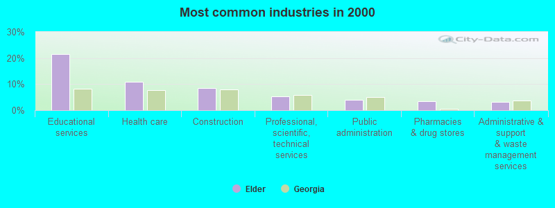
- Educational services (21.4%)
- Health care (10.8%)
- Construction (8.5%)
- Professional, scientific, technical services (5.2%)
- Public administration (3.9%)
- Pharmacies & drug stores (3.5%)
- Administrative & support & waste management services (3.3%)
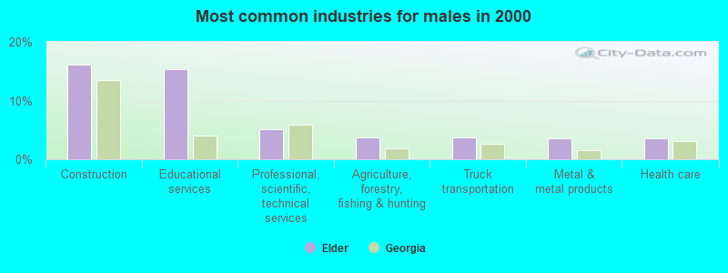
- Construction (16.1%)
- Educational services (15.3%)
- Professional, scientific, technical services (5.2%)
- Agriculture, forestry, fishing & hunting (3.8%)
- Truck transportation (3.8%)
- Metal & metal products (3.6%)
- Health care (3.6%)
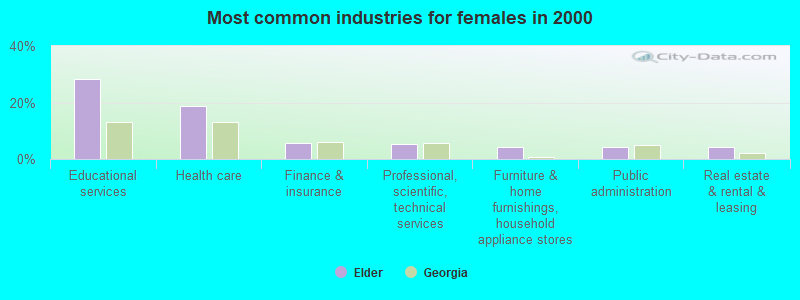
- Educational services (28.2%)
- Health care (18.9%)
- Finance & insurance (5.8%)
- Professional, scientific, technical services (5.3%)
- Furniture & home furnishings, household appliance stores (4.2%)
- Public administration (4.2%)
- Real estate & rental & leasing (4.2%)
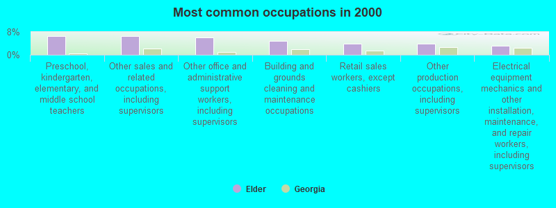
- Preschool, kindergarten, elementary, and middle school teachers (6.5%)
- Other sales and related occupations, including supervisors (6.5%)
- Other office and administrative support workers, including supervisors (6.1%)
- Building and grounds cleaning and maintenance occupations (4.9%)
- Retail sales workers, except cashiers (3.9%)
- Other production occupations, including supervisors (3.8%)
- Electrical equipment mechanics and other installation, maintenance, and repair workers, including supervisors (3.3%)
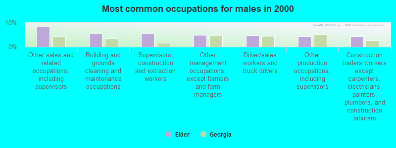
- Other sales and related occupations, including supervisors (8.5%)
- Building and grounds cleaning and maintenance occupations (5.6%)
- Supervisors, construction and extraction workers (5.6%)
- Other management occupations, except farmers and farm managers (5.0%)
- Driver/sales workers and truck drivers (4.8%)
- Other production occupations, including supervisors (4.4%)
- Construction traders workers except carpenters, electricians, painters, plumbers, and construction laborers (4.4%)
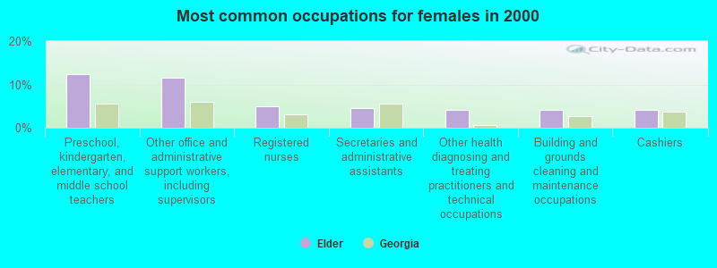
- Preschool, kindergarten, elementary, and middle school teachers (12.4%)
- Other office and administrative support workers, including supervisors (11.6%)
- Registered nurses (4.9%)
- Secretaries and administrative assistants (4.4%)
- Other health diagnosing and treating practitioners and technical occupations (4.2%)
- Building and grounds cleaning and maintenance occupations (4.2%)
- Cashiers (4.2%)
Average climate in Elder, Georgia
Based on data reported by over 4,000 weather stations


(lower is better)
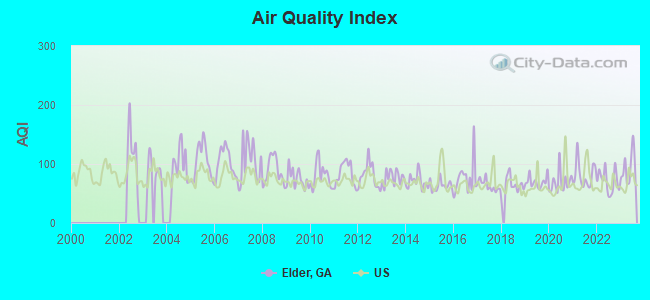
Air Quality Index (AQI) level in 2023 was 93.7. This is worse than average.
| City: | 93.7 |
| U.S.: | 72.6 |
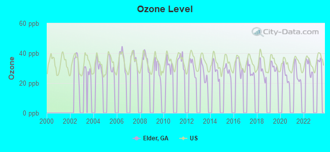
Ozone [ppb] level in 2022 was 30.7. This is about average. Closest monitor was 10.3 miles away from the city center.
| City: | 30.7 |
| U.S.: | 33.3 |
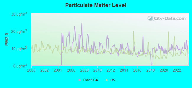
Particulate Matter (PM2.5) [µg/m3] level in 2023 was 10.9. This is worse than average. Closest monitor was 10.3 miles away from the city center.
| City: | 10.9 |
| U.S.: | 8.1 |
Tornado activity:
Elder-area historical tornado activity is near Georgia state average. It is 20% greater than the overall U.S. average.
On 11/22/1992, a category F4 (max. wind speeds 207-260 mph) tornado 27.2 miles away from the Elder place center killed 5 people and injured 86 people and caused between $5,000,000 and $50,000,000 in damages.
On 5/28/1973, a category F3 (max. wind speeds 158-206 mph) tornado 13.8 miles away from the place center killed one person and injured 65 people and caused between $5,000,000 and $50,000,000 in damages.
Earthquake activity:
Elder-area historical earthquake activity is significantly above Georgia state average. It is 23% greater than the overall U.S. average.On 8/2/1974 at 08:52:09, a magnitude 4.9 (4.3 MB, 4.9 LG, Class: Light, Intensity: IV - V) earthquake occurred 49.2 miles away from the city center
On 4/29/2003 at 08:59:39, a magnitude 4.9 (4.4 MB, 4.6 MW, 4.9 LG) earthquake occurred 140.5 miles away from the city center
On 11/30/1973 at 07:48:41, a magnitude 4.7 (4.7 MB, 4.6 ML) earthquake occurred 144.8 miles away from the city center
On 8/9/2020 at 12:07:37, a magnitude 5.1 (5.1 MW, Depth: 4.7 mi, Class: Moderate, Intensity: VI - VII) earthquake occurred 226.1 miles away from Elder center
On 4/29/2003 at 08:59:39, a magnitude 4.6 (4.6 MW, Depth: 12.3 mi) earthquake occurred 140.5 miles away from the city center
On 2/15/2014 at 03:23:38, a magnitude 4.1 (4.1 MW, Depth: 3.2 mi) earthquake occurred 71.6 miles away from the city center
Magnitude types: regional Lg-wave magnitude (LG), body-wave magnitude (MB), local magnitude (ML), moment magnitude (MW)
Natural disasters:
The number of natural disasters in Oconee County (7) is smaller than the US average (15).Major Disasters (Presidential) Declared: 2
Emergencies Declared: 4
Causes of natural disasters: Winter Storms: 3, Drought: 1, Flood: 1, Hurricane: 1, Snowfall: 1, Tornado: 1, Other: 1 (Note: some incidents may be assigned to more than one category).
Hospitals and medical centers near Elder:
- ODYSSEY HEALTHCARE OF ATHENS (Hospital, about 12 miles away; ATHENS, GA)
- HEARTLAND HOSPICE SERVICES ( ATHENS ) (Hospital, about 12 miles away; ATHENS, GA)
- NEW HORIZON HEALTH CARE (Nursing Home, about 13 miles away; ATHENS, GA)
- ST MARY'S HOSPITAL Acute Care Hospitals (about 13 miles away; ATHENS, GA)
- ATHENS HEALTH CARE CENTER (Nursing Home, about 14 miles away; ATHENS, GA)
- HERITAGE HEALTHCARE OF ATHENS (Nursing Home, about 14 miles away; ATHENS, GA)
- UNIVERSITY NURSING AND REHAB CTR (Nursing Home, about 14 miles away; ATHENS, GA)
Colleges/universities with over 2000 students nearest to Elder:
- University of Georgia (about 14 miles; Athens, GA; Full-time enrollment: 32,679)
- Athens Technical College (about 16 miles; Athens, GA; FT enrollment: 3,204)
- Georgia Gwinnett College (about 41 miles; Lawrenceville, GA; FT enrollment: 7,993)
- Gwinnett Technical College (about 44 miles; Lawrenceville, GA; FT enrollment: 5,138)
- Lanier Technical College (about 45 miles; Oakwood, GA; FT enrollment: 2,435)
- Brenau University (about 47 miles; Gainesville, GA; FT enrollment: 2,341)
- Georgia College and State University (about 48 miles; Milledgeville, GA; FT enrollment: 6,271)
Points of interest:
Notable locations in Elder: Green Hills Country Club (A), Barnett Shoals (B), Oconee County Fire Department Station 5 (C). Display/hide their locations on the map
Churches in Elder include: Walnut Grove Church (A), Salem United Methodist Church (B), Salem Church (C), Corinth Church (D), Antioch Church (E). Display/hide their locations on the map
Cemeteries: Willoughby Cemetery (1), Young Cemetery (2), Big Creek Hardshell Cemetery (3), Marshall Cemetery (4), Mayne Cemetery (5), Elder Cemetery (6), Hardigree Cemetery (7). Display/hide their locations on the map
Reservoirs: Elders Lakes (A), Lower Elders Lake (B), Upper Elders Lake (C). Display/hide their locations on the map
Streams, rivers, and creeks: Slab Camp Creek (A), Shoal Creek (B), Rocky Branch (C), Little Rose Creek (D), Buck Branch (E), Wildcat Creek (F). Display/hide their locations on the map
| This place: | 2.7 people |
| Georgia: | 2.6 people |
| This place: | 79.0% |
| Whole state: | 68.5% |
| This place: | 4.1% |
| Whole state: | 5.9% |
Likely homosexual households (counted as self-reported same-sex unmarried-partner households)
- Lesbian couples: 0.5% of all households
- Gay men: 0.4% of all households
| This place: | 2.9% |
| Whole state: | 13.0% |
| This place: | 1.3% |
| Whole state: | 6.1% |
For population 15 years and over in Elder:
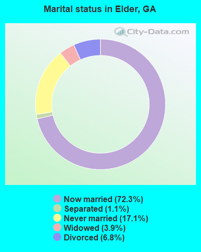
- Never married: 17.1%
- Now married: 72.3%
- Separated: 1.1%
- Widowed: 3.9%
- Divorced: 6.8%
For population 25 years and over in Elder:
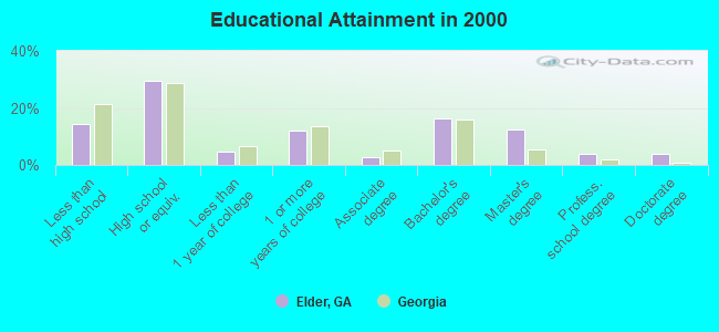
- High school or higher: 85.7%
- Bachelor's degree or higher: 36.2%
- Graduate or professional degree: 20.1%
- Unemployed: 1.1%
- Mean travel time to work (commute): 28.0 minutes
| Here: | 13.6 |
| Georgia average: | 13.3 |
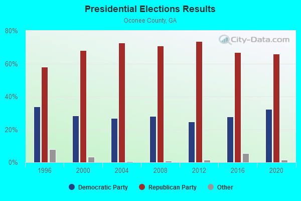
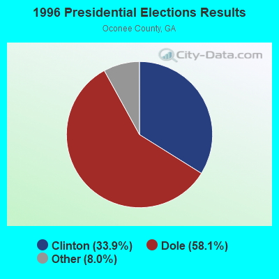

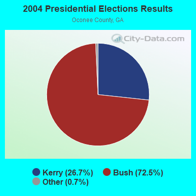

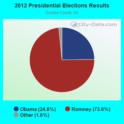
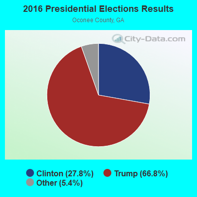
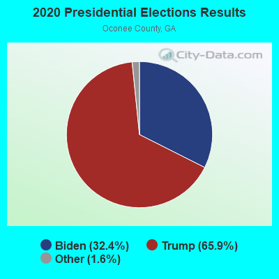
Graphs represent county-level data. Detailed 2008 Election Results
Religion statistics for Elder, GA (based on Oconee County data)
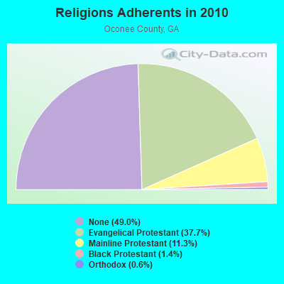
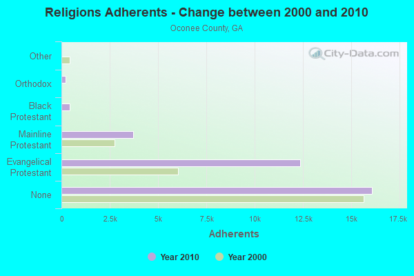
| Religion | Adherents | Congregations |
|---|---|---|
| Evangelical Protestant | 12,353 | 26 |
| Mainline Protestant | 3,723 | 14 |
| Black Protestant | 445 | 3 |
| Orthodox | 200 | 1 |
| Other | 13 | - |
| None | 16,074 | - |
Food Environment Statistics:
| Oconee County: | 0.96 / 10,000 pop. |
| Georgia: | 1.91 / 10,000 pop. |
| This county: | 0.32 / 10,000 pop. |
| State: | 0.15 / 10,000 pop. |
| Here: | 4.48 / 10,000 pop. |
| State: | 5.12 / 10,000 pop. |
| Oconee County: | 5.76 / 10,000 pop. |
| Georgia: | 7.41 / 10,000 pop. |
| Oconee County: | 9.5% |
| Georgia: | 10.4% |
| This county: | 28.2% |
| State: | 27.8% |
| Oconee County: | 18.3% |
| Georgia: | 14.6% |
Strongest AM radio stations in Elder:
- WCNN (680 AM; 50 kW; NORTH ATLANTA, GA; Owner: DICKEY BROADCASTING COMPANY)
- WSB (750 AM; 50 kW; ATLANTA, GA; Owner: CXR HOLDINGS, INC.)
- WRFC (960 AM; 5 kW; ATHENS, GA; Owner: SOUTHERN BROADCASTING OF ATHENS, INC)
- WGST (640 AM; 50 kW; ATLANTA, GA; Owner: CITICASTERS LICENSES, L.P.)
- WBKZ (880 AM; daytime; 5 kW; JEFFERSON, GA; Owner: BROWN BROADCASTING SYSTEM, INC.)
- WGUN (1010 AM; 50 kW; ATLANTA, GA; Owner: WGUN, INC.)
- WMAC (940 AM; 50 kW; MACON, GA; Owner: CUMULUS LICENSING CORP.)
- WQXI (790 AM; 28 kW; ATLANTA, GA; Owner: JEFFERSON-PILOT COMMUNICATIONS COMPANY OF GEORGIA)
- WAOK (1380 AM; 50 kW; ATLANTA, GA; Owner: INFINITY BROADCASTING OPERATIONS, INC.)
- WLFJ (660 AM; daytime; 50 kW; GREENVILLE, SC; Owner: CLEAR CHANNEL BROADCASTING LICENSES, INC.)
- WMLB (1160 AM; 50 kW; EAST POINT, GA; Owner: ATLANTA AREA BROADCASTING, INC.)
- WDUN (550 AM; 10 kW; GAINESVILLE, GA; Owner: JWJ PROPERTIRS, INC.)
- WFTD (1080 AM; daytime; 50 kW; MARIETTA, GA; Owner: PRIETO ENTERPRISES, INC.)
Strongest FM radio stations in Elder:
- WFSH-FM (104.7 FM; ATHENS, GA; Owner: SOUTH TEXAS BROADCASTING, INC.)
- WBTS (95.5 FM; ATHENS, GA; Owner: CXR HOLDINGS, INC.)
- WGMG (102.1 FM; CRAWFORD, GA; Owner: NEW BROADCAST INVESTMENT PROPERTIES, INC)
- WPMA (102.7 FM; BUCKHEAD, GA; Owner: BARINOWSKI INVESTMENT COMPANY, L.P.)
- WUGA (91.7 FM; ATHENS, GA; Owner: GEORGIA PUBLIC TELECOMMUNICATIONS COMMISSION)
- WFOX (97.1 FM; GAINESVILLE, GA; Owner: COX RADIO, INC.)
- WMOQ (92.3 FM; BOSTWICK, GA; Owner: BOSTWICK BROADCASTING GROUP, INC.)
- WYAY (106.7 FM; GAINESVILLE, GA; Owner: ABC, INC.)
- WMSL (88.9 FM; ATHENS, GA; Owner: PRINCE AVENUE BAPTIST CHRISTIAN SCHOOL)
- WNGC (106.1 FM; TOCCOA, GA; Owner: SOUTHERN BROADCASTING OF PENSACOLA, INC)
- W250AC (97.9 FM; ATHENS, GA; Owner: GEORGIA PUBLIC TELECOMMUNICATIONS COMMISSION)
- WUOG (90.5 FM; ATHENS, GA; Owner: THE UNIVERSITY OF GEORGIA)
- WMGZ (97.7 FM; EATONTON, GA; Owner: MIDDLE GEORGIA COMMUNICATIONS, INC.)
- WDDK (103.9 FM; GREENSBORO, GA; Owner: BRIARPATCH RADIO INC.)
- W203BK (88.5 FM; ATHENS, GA; Owner: CALVARY CHAPEL OF TWIN FALLS, INC.)
TV broadcast stations around Elder:
- W42AO (Channel 42; ATHENS, GA; Owner: GEORGIA REGIONAL COMMUNITY TV)
- W22AC (Channel 22; HARTWELL & ROYSTON, GA; Owner: GEORGIA PUBLIC TELECOMMUNICATIONS COMMISSION)
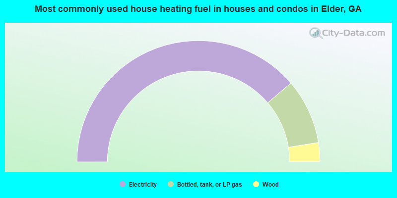
- 77.5%Electricity
- 17.4%Bottled, tank, or LP gas
- 5.1%Wood
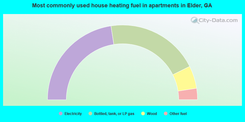
- 45.1%Electricity
- 40.2%Bottled, tank, or LP gas
- 9.8%Wood
- 4.9%Other fuel
Elder compared to Georgia state average:
- Median house value above state average.
- Unemployed percentage significantly below state average.
- Black race population percentage significantly below state average.
- Hispanic race population percentage significantly below state average.
- Foreign-born population percentage significantly below state average.
- Renting percentage significantly below state average.
- Length of stay since moving in significantly above state average.
- Number of rooms per house significantly below state average.
- House age significantly below state average.
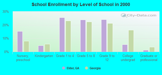
- Number of college students below state average.
- Percentage of population with a bachelor's degree or higher above state average.