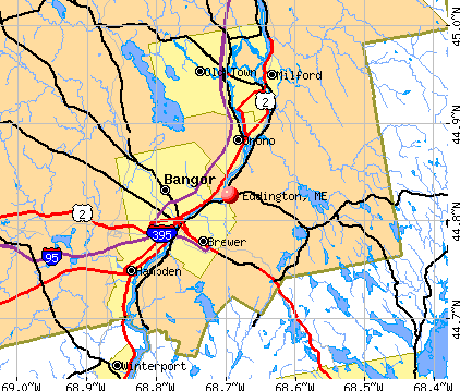
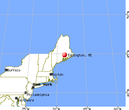
Eddington, Maine

Submit your own pictures of this town and show them to the world
- OSM Map
- General Map
- Google Map
- MSN Map
Population change since 2000: +8.4%
 |
| Males: 1,105 | |
| Females: 1,120 |
| Median resident age: | 44.1 years |
| Maine median age: | 43.0 years |
Zip codes: 04428.
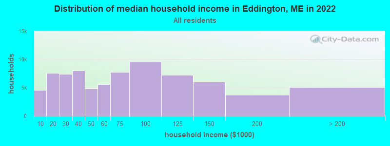
| Eddington: | $71,793 |
| ME: | $69,543 |
Estimated per capita income in 2022: $38,422 (it was $19,113 in 2000)
Eddington town income, earnings, and wages data
Estimated median house or condo value in 2022: $221,176 (it was $85,000 in 2000)
| Eddington: | $221,176 |
| ME: | $290,600 |
Mean prices in 2022: all housing units: $235,563; detached houses: $252,705; townhouses or other attached units: $267,749; in 2-unit structures: $255,332; in 3-to-4-unit structures: $815,300; in 5-or-more-unit structures: $185,873; mobile homes: $93,017; occupied boats, rvs, vans, etc.: $21,333
Detailed information about poverty and poor residents in Eddington, ME


- 2,16997.5%White alone
- 150.7%Two or more races
- 130.6%Black alone
- 110.5%Asian alone
- 100.4%American Indian alone
- 70.3%Hispanic
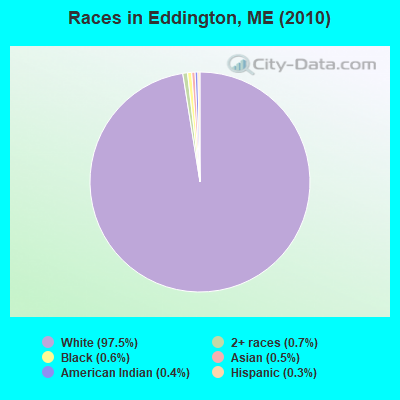
Races in Eddington detailed stats: ancestries, foreign born residents, place of birth
According to our research of Maine and other state lists, there were 2 registered sex offenders living in Eddington, Maine as of May 07, 2024.
The ratio of all residents to sex offenders in Eddington is 1,113 to 1.
The ratio of registered sex offenders to all residents in this city is lower than the state average.
 Recent articles from our blog. Our writers, many of them Ph.D. graduates or candidates, create easy-to-read articles on a wide variety of topics.

 | Gazelle Canoes (13 replies) |
| Very beginning of researching a move to Maine (14 replies) |
| Moving in my RV to Maine to search for a house in Bangor ME area, advice as to finding a homestead (21 replies) |
| Maine weather thread (3207 replies) |
| Looking to move outside Bangor with kids (6 replies) |
| Which part/cities of Maine should we explore first as potential transplants? (38 replies) |
Latest news from Eddington, ME collected exclusively by city-data.com from local newspapers, TV, and radio stations
Ancestries: English (20.3%), French (15.2%), Irish (14.1%), United States (13.8%), Scottish (5.7%), German (5.1%).
Current Local Time: EST time zone
Incorporated on 02/22/1811
Elevation: 146 feet
Land area: 25.1 square miles.
Population density: 89 people per square mile (very low).
35 residents are foreign born
| This town: | 1.7% |
| Maine: | 2.9% |
| Eddington town: | 1.1% ($915) |
| Maine: | 1.5% ($1,417) |
Nearest city with pop. 50,000+: Portland, ME  (113.3 miles , pop. 64,249).
Nearest city with pop. 200,000+: Boston, MA (211.2 miles , pop. 589,141).
Nearest city with pop. 1,000,000+: Bronx, NY (381.7 miles , pop. 1,332,650).
Nearest cities:
), ), ), ), ), ), Latitude: 44.79 N, Longitude: 68.61 W
Area code: 207

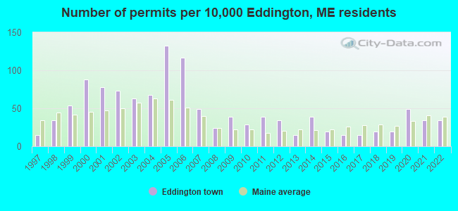
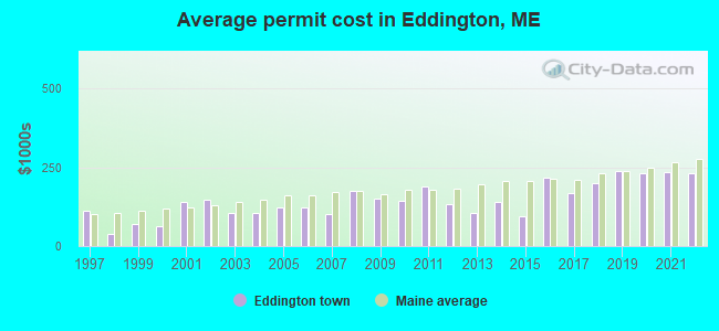
Single-family new house construction building permits:
- 2022: 7 buildings, average cost: $233,400
- 2021: 7 buildings, average cost: $235,600
- 2020: 10 buildings, average cost: $230,400
- 2019: 4 buildings, average cost: $237,500
- 2018: 4 buildings, average cost: $200,000
- 2017: 3 buildings, average cost: $168,000
- 2016: 3 buildings, average cost: $216,700
- 2015: 4 buildings, average cost: $92,500
- 2014: 8 buildings, average cost: $140,600
- 2013: 3 buildings, average cost: $106,700
- 2012: 7 buildings, average cost: $134,600
- 2011: 8 buildings, average cost: $188,300
- 2010: 6 buildings, average cost: $144,800
- 2009: 8 buildings, average cost: $151,300
- 2008: 5 buildings, average cost: $177,000
- 2007: 10 buildings, average cost: $103,300
- 2006: 24 buildings, average cost: $123,400
- 2005: 27 buildings, average cost: $123,400
- 2004: 14 buildings, average cost: $107,100
- 2003: 13 buildings, average cost: $104,100
- 2002: 15 buildings, average cost: $147,500
- 2001: 16 buildings, average cost: $139,700
- 2000: 18 buildings, average cost: $61,900
- 1999: 11 buildings, average cost: $70,600
- 1998: 7 buildings, average cost: $39,400
- 1997: 3 buildings, average cost: $111,800
| Here: | 2.9% |
| Maine: | 3.4% |
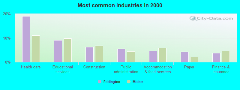
- Health care (19.0%)
- Educational services (9.0%)
- Construction (6.2%)
- Public administration (5.6%)
- Accommodation & food services (4.7%)
- Paper (4.4%)
- Finance & insurance (3.7%)
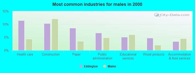
- Health care (11.4%)
- Construction (10.3%)
- Paper (8.5%)
- Public administration (6.7%)
- Educational services (5.1%)
- Wood products (4.7%)
- Accommodation & food services (3.4%)
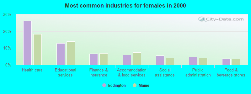
- Health care (26.3%)
- Educational services (12.9%)
- Finance & insurance (6.7%)
- Accommodation & food services (6.0%)
- Social assistance (5.7%)
- Public administration (4.6%)
- Food & beverage stores (3.7%)
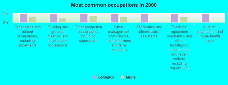
- Other sales and related occupations, including supervisors (3.9%)
- Building and grounds cleaning and maintenance occupations (3.9%)
- Other production occupations, including supervisors (3.9%)
- Other management occupations, except farmers and farm managers (3.8%)
- Secretaries and administrative assistants (3.8%)
- Electrical equipment mechanics and other installation, maintenance, and repair workers, including supervisors (3.6%)
- Nursing, psychiatric, and home health aides (3.6%)
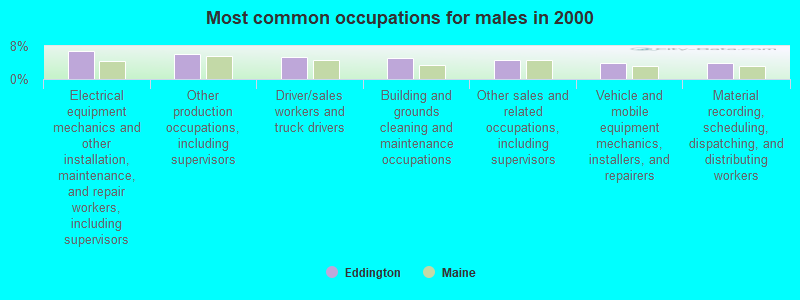
- Electrical equipment mechanics and other installation, maintenance, and repair workers, including supervisors (6.9%)
- Other production occupations, including supervisors (6.2%)
- Driver/sales workers and truck drivers (5.4%)
- Building and grounds cleaning and maintenance occupations (5.1%)
- Other sales and related occupations, including supervisors (4.7%)
- Vehicle and mobile equipment mechanics, installers, and repairers (3.8%)
- Material recording, scheduling, dispatching, and distributing workers (3.8%)

- Secretaries and administrative assistants (7.4%)
- Nursing, psychiatric, and home health aides (6.2%)
- Registered nurses (5.8%)
- Other office and administrative support workers, including supervisors (5.3%)
- Preschool, kindergarten, elementary, and middle school teachers (3.7%)
- Other management occupations, except farmers and farm managers (3.7%)
- Cashiers (3.4%)
Average climate in Eddington, Maine
Based on data reported by over 4,000 weather stations


(lower is better)
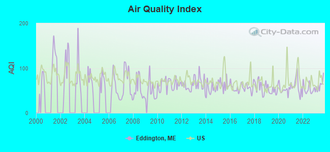
Air Quality Index (AQI) level in 2023 was 61.1. This is about average.
| City: | 61.1 |
| U.S.: | 72.6 |
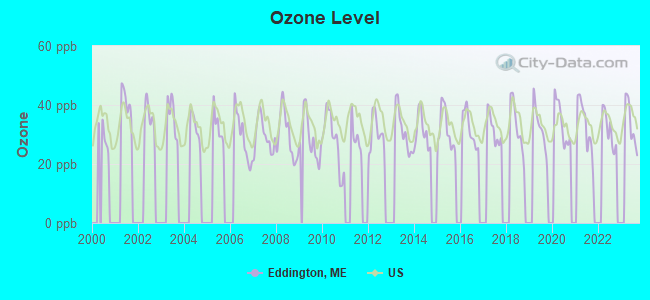
Ozone [ppb] level in 2023 was 33.6. This is about average. Closest monitor was 4.9 miles away from the city center.
| City: | 33.6 |
| U.S.: | 33.3 |
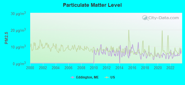
Particulate Matter (PM2.5) [µg/m3] level in 2023 was 5.62. This is significantly better than average. Closest monitor was 8.1 miles away from the city center.
| City: | 5.62 |
| U.S.: | 8.11 |
Earthquake activity:
Eddington-area historical earthquake activity is significantly above Maine state average. It is 82% smaller than the overall U.S. average.On 10/16/2012 at 23:12:25, a magnitude 4.7 (4.7 ML, Depth: 10.0 mi, Class: Light, Intensity: IV - V) earthquake occurred 130.9 miles away from the city center
On 4/20/2002 at 10:50:47, a magnitude 5.3 (5.3 ML, Depth: 3.0 mi, Class: Moderate, Intensity: VI - VII) earthquake occurred 251.2 miles away from Eddington center
On 4/20/2002 at 10:50:47, a magnitude 5.2 (5.2 MB, 4.2 MS, 5.2 MW, 5.0 MW) earthquake occurred 252.4 miles away from Eddington center
On 1/19/1982 at 00:14:42, a magnitude 4.7 (4.5 MB, 4.7 MD, 4.5 LG) earthquake occurred 173.3 miles away from Eddington center
On 10/7/1983 at 10:18:46, a magnitude 5.3 (5.1 MB, 5.3 LG, 5.1 ML) earthquake occurred 289.4 miles away from the city center
On 2/26/1999 at 03:38:43, a magnitude 3.8 (3.8 LG, Depth: 2.0 mi, Class: Light, Intensity: II - III) earthquake occurred 49.8 miles away from the city center
Magnitude types: regional Lg-wave magnitude (LG), body-wave magnitude (MB), duration magnitude (MD), local magnitude (ML), surface-wave magnitude (MS), moment magnitude (MW)
Natural disasters:
The number of natural disasters in Penobscot County (19) is greater than the US average (15).Major Disasters (Presidential) Declared: 11
Emergencies Declared: 7
Causes of natural disasters: Floods: 9, Storms: 8, Snows: 5, Heavy Rains: 2, Blizzard: 1, Hurricane: 1, Ice Storm: 1, Snowfall: 1, Wind: 1, Winter Storm: 1, Other: 2 (Note: some incidents may be assigned to more than one category).
Hospitals and medical centers in Eddington:
Other hospitals and medical centers near Eddington:
- MAINE VETERANS HOME - BANGOR (Nursing Home, about 7 miles away; BANGOR, ME)
- ELIZABETH LEVINSON CENTER (Hospital, about 7 miles away; BANGOR, ME)
- EASTERN MAINE MEDICAL CENTER Acute Care Hospitals (about 8 miles away; BANGOR, ME)
- KINDRED TRANSITIONAL CARE AND REHAB-BREWER (Nursing Home, about 8 miles away; BREWER, ME)
- TREATS FALLS HOUSE (Hospital, about 8 miles away; ORONO, ME)
- HOSPICE OF EASTERN MAINE HHA (Home Health Center, about 8 miles away; BANGOR, ME)
- STILLWATER HEALTH CARE (Nursing Home, about 8 miles away; BANGOR, ME)
Colleges/universities with over 2000 students nearest to Eddington:
- University of Maine (about 9 miles; Orono, ME; Full-time enrollment: 8,931)
- Husson University (about 10 miles; Bangor, ME; FT enrollment: 2,421)
- University of Maine at Augusta (about 67 miles; Augusta, ME; FT enrollment: 3,204)
- University of Maine at Farmington (about 77 miles; Farmington, ME; FT enrollment: 2,036)
- Southern Maine Community College (about 113 miles; South Portland, ME; FT enrollment: 4,666)
- University of Southern Maine (about 114 miles; Portland, ME; FT enrollment: 6,647)
- Saint Joseph's College of Maine (about 115 miles; Standish, ME; FT enrollment: 2,010)
Public elementary/middle school in Eddington:
- EDDINGTON SCHOOL (Students: 213, Location: 440 MAIN ROAD, Grades: PK-4)
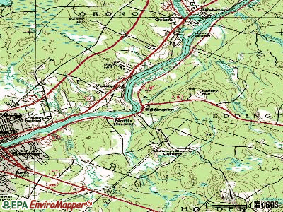
Points of interest:
Notable location: Eddington Fire Department (A). Display/hide its location on the map
Churches in Eddington include: East Eddington Community Church (A), North Brewer-Eddington Methodist Church (B). Display/hide their locations on the map
Cemeteries: North Eddington Cemetery (1), Meadowbrook Cemetery (2), Pine Tree Cemetery (3). Display/hide their locations on the map
Lakes and swamps: Davis Pond (A), Holbrook Pond (B), Cummings Bog (C). Display/hide their locations on the map
Streams, rivers, and creeks: Kidder Brook (A), Meadow Brook (B), Mill Brook (C). Display/hide their locations on the map
Drinking water stations with addresses in Eddington and their reported violations in the past:
KSR-PETER VIGUE CENTER (Population served: 200, Groundwater):Past monitoring violations:DEANS LANDING (Population served: 80, Groundwater):
- 11 routine major monitoring violations
- 2 regular monitoring violations
Past health violations:LUCERNE BEACH CLUB (Population served: 40, Groundwater):
- MCL, Acute (TCR) - In MAY-2011, Contaminant: Coliform. Follow-up actions: St Tech Assistance Visit (MAY-20-2011), St Boil Water Order (MAY-20-2011), St Formal NOV issued (MAY-20-2011), St Public Notif requested (MAY-20-2011), St Public Notif received (MAY-31-2011), St Compliance achieved (JUL-05-2011)
Past health violations:Past monitoring violations:
- MCL, Monthly (TCR) - In JUL-2013, Contaminant: Coliform. Follow-up actions: St Public Notif requested (AUG-07-2013), St Formal NOV issued (AUG-07-2013), St Site Visit (enforcement) (MAY-28-2014), St Public Notif received (MAY-28-2014), St Compliance achieved (JUN-16-2014)
- MCL, Monthly (TCR) - In JUL-2006, Contaminant: Coliform. Follow-up actions: St Violation/Reminder Notice (JUL-17-2006), St Public Notif requested (JUL-17-2006), St Public Notif received (2 times from AUG-08-2006 to AUG-08-2006), St Compliance achieved (SEP-07-2011)
- 16 routine major monitoring violations
- One minor monitoring violation
- 5 regular monitoring violations
| This town: | 2.4 people |
| Maine: | 2.3 people |
| This town: | 69.1% |
| Whole state: | 62.9% |
| This town: | 9.8% |
| Whole state: | 9.4% |
Likely homosexual households (counted as self-reported same-sex unmarried-partner households)
- Lesbian couples: 0.4% of all households
- Gay men: 0.3% of all households
| This town: | 6.7% |
| Whole state: | 10.9% |
| This town: | 3.0% |
| Whole state: | 4.1% |
5 people in residential treatment centers for adults in 2010
People in group quarters in Eddington in 2000:
- 11 people in homes for the mentally retarded
- 7 people in training schools for juvenile delinquents
- 6 people in homes or halfway houses for drug/alcohol abuse
For population 15 years and over in Eddington:
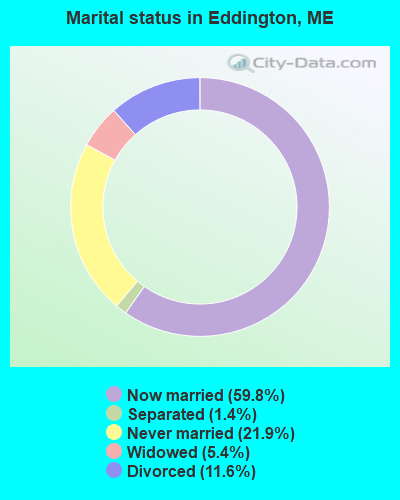
- Never married: 21.9%
- Now married: 59.8%
- Separated: 1.4%
- Widowed: 5.4%
- Divorced: 11.6%
For population 25 years and over in Eddington:
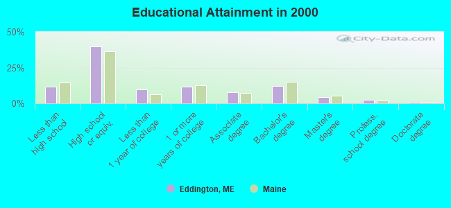
- High school or higher: 88.3%
- Bachelor's degree or higher: 19.8%
- Graduate or professional degree: 7.7%
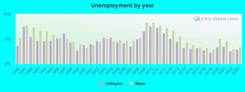
- Unemployed: 4.8%
- Mean travel time to work (commute): 22.7 minutes
| Here: | 10.3 |
| Maine average: | 11.2 |


Graphs represent county-level data. Detailed 2008 Election Results
Religion statistics for Eddington, ME (based on Penobscot County data)


| Religion | Adherents | Congregations |
|---|---|---|
| Catholic | 16,581 | 15 |
| Mainline Protestant | 9,715 | 59 |
| Evangelical Protestant | 7,523 | 80 |
| Other | 2,936 | 22 |
| Orthodox | 300 | 1 |
| None | 116,868 | - |
Food Environment Statistics:
| Penobscot County: | 2.29 / 10,000 pop. |
| Maine: | 2.80 / 10,000 pop. |
| Penobscot County: | 0.13 / 10,000 pop. |
| Maine: | 0.14 / 10,000 pop. |
| Penobscot County: | 2.56 / 10,000 pop. |
| Maine: | 2.20 / 10,000 pop. |
| Penobscot County: | 5.72 / 10,000 pop. |
| Maine: | 5.75 / 10,000 pop. |
| Penobscot County: | 7.41 / 10,000 pop. |
| Maine: | 11.02 / 10,000 pop. |
| Penobscot County: | 9.0% |
| State: | 8.2% |
| This county: | 28.0% |
| Maine: | 25.0% |
Businesses in Eddington, ME
- Dunkin Donuts: 1
Strongest AM radio stations in Eddington:
- WABI (910 AM; 5 kW; BANGOR, ME; Owner: CLEAR CHANNEL BROADCASTING LICENSES, INC.)
- WZON (620 AM; 5 kW; BANGOR, ME; Owner: THE ZONE CORPORATION)
- WNZS (1340 AM; 1 kW; VEAZIE, ME; Owner: WATERFRONT COMMUNICATIONS INC.)
- WDEA (1370 AM; 5 kW; ELLSWORTH, ME; Owner: CUMULUS LICENSING CORP.)
- WSKW (1160 AM; 10 kW; SKOWHEGAN, ME; Owner: MOUNTAIN WIRELESS, INCORPORATED)
- WRKO (680 AM; 50 kW; BOSTON, MA; Owner: ENTERCOM BOSTON LICENSE, LLC)
- WTME (780 AM; 10 kW; RUMFORD, ME; Owner: MOUNTAIN VALLEY BROADCASTING, INC.)
- WEEI (850 AM; 50 kW; BOSTON, MA; Owner: ENTERCOM BOSTON LICENSE, LLC)
- WBZ (1030 AM; 50 kW; BOSTON, MA; Owner: INFINITY BROADCASTING OPERATIONS, INC.)
- WCRN (830 AM; 50 kW; WORCESTER, MA; Owner: CARTER BROADCASTING CORPORATION)
- WNNZ (640 AM; 50 kW; WESTFIELD, MA; Owner: CLEAR CHANNEL BROADCASTING LICENSES, INC.)
- WKOX (1200 AM; 50 kW; FRAMINGHAM, MA; Owner: CAPSTAR TX LIMITED PARTNERSHIP)
- WALE (990 AM; 50 kW; GREENVILLE, RI; Owner: NORTH AMERICAN BROADCASTING CO., INC.)
Strongest FM radio stations in Eddington:
- WMEH (90.9 FM; BANGOR, ME; Owner: MAINE PUBLIC BROADCASTING CORPORATION)
- WEZQ (92.9 FM; BANGOR, ME; Owner: CUMULUS LICENSING CORP.)
- WWMJ (95.7 FM; ELLSWORTH, ME; Owner: CUMULUS LICENSING CORP.)
- WKIT-FM (100.3 FM; BREWER, ME; Owner: THE ZONE CORPORATION)
- WHCF (88.5 FM; BANGOR, ME; Owner: BANGOR BAPTIST CHURCH)
- WBFB (104.7 FM; BELFAST, ME; Owner: CLEAR CHANNEL BROADCASTING LICENSES, INC.)
- WVOM (103.9 FM; HOWLAND, ME; Owner: CLEAR CHANNEL BROADCASTING LICENSES, INC.)
- WWBX (97.1 FM; BANGOR, ME; Owner: CLEAR CHANNEL BROADCASTING LICENSES, INC.)
- WBZN (107.3 FM; OLD TOWN, ME; Owner: CUMULUS LICENSING CORP.)
- WERU-FM (89.9 FM; BLUE HILL, ME; Owner: SALT POND COMMUNITY B/C COMPANY)
- WFZX (101.7 FM; SEARSPORT, ME; Owner: CLEAR CHANNEL BROADCASTING LICENSES, INC.)
- WNSX (97.7 FM; WINTER HARBOR, ME; Owner: CLEAR CHANNEL BROADCASTING LICENSES, INC.)
- WQCB (106.5 FM; BREWER, ME; Owner: CUMULUS LICENSING CORP.)
- WMEB-FM (91.9 FM; ORONO, ME; Owner: UNIVERSITY OF MAINE SYSTEM)
- WLKE (99.1 FM; BAR HARBOR, ME; Owner: CLEAR CHANNEL BROADCASTING LICENSES, INC.)
- WMEP (90.5 FM; CAMDEN, ME; Owner: MAINE PUBLIC BROADCASTING CORP.)
- WQSS (102.5 FM; CAMDEN, ME; Owner: CLEAR CHANNEL BROADCASTING LICENSES, INC.)
- WBQI (107.7 FM; BAR HARBOR, ME; Owner: MARINER BROADCASTING, L.P.)
- W275AE (102.9 FM; BANGOR, ME; Owner: SALT POND COMMUNITY BROADCASTING, INC.)
- WHSN (89.3 FM; BANGOR, ME; Owner: HUSSON COLLEGE)
TV broadcast stations around Eddington:
- WMEB-TV (Channel 12; ORONO, ME; Owner: MAINE PUBLIC BROADCASTING CORPORATION)
- W66CL (Channel 66; BANGOR, ME; Owner: MS COMMUNICATIONS, LLC)
- WBAN-LP (Channel 9; BANGOR, ME; Owner: BANGOR MEDIA GROUP, LLC)
- WVII-TV (Channel 7; BANGOR, ME; Owner: BANGOR COMMUNICATIONS, INC.)
- WLBZ (Channel 2; BANGOR, ME; Owner: PACIFIC AND SOUTHERN COMPANY, INC.)
- WFVX-LP (Channel 22; BANGOR, ME; Owner: ROCKFLEET BROADCASTING III, LLC)
- W39CC (Channel 39; BANGOR, ME; Owner: MS COMMUNICATIONS, LLC)
- W42BZ (Channel 42; BANGOR, ME; Owner: MS COMMUNICATIONS, LLC)
- W50BX (Channel 50; BANGOR, ME; Owner: MS COMMUNICATIONS, LLC)
- W54CG (Channel 54; BANGOR, ME; Owner: MS COMMUNICATIONS, LLC)
- WBGR-LP (Channel 33; BANGOR/DEDHAM, ME; Owner: MAINE FAMILY BROADCASTING, INC.)
- WCKD-LP (Channel 30; BANGOR/DEDHAM, ME; Owner: J. MCLEOD, ME FAMILY B/CING., INC.)
- WABI-TV (Channel 5; BANGOR, ME; Owner: COMMUNITY BROADCASTING SERVICE)
- W36CK (Channel 36; BANGOR, ME; Owner: TRINITY BROADCASTING NETWORK)
- National Bridge Inventory (NBI) Statistics
- 1Number of bridges
- 3ft / 1.0mTotal length
- 4,216Total average daily traffic
- 210Total average daily truck traffic
- 5,902Total future (year 2036) average daily traffic
FCC Registered Antenna Towers:
13 (See the full list of FCC Registered Antenna Towers in Eddington)FCC Registered Broadcast Land Mobile Towers:
4- 2.5 Mi Sse (Lat: 44.757583 Lon: -68.565583), Structure height: 38 m, Call Sign: WNFH691,
Assigned Frequencies: 456.350 MHz, 456.425 MHz, Grant Date: 04/27/2011, Expiration Date: 04/24/2021, Cancellation Date: 11/14/2012, Certifier: Shirley J Linn, Registrant: Fairpoint Communications, Inc., 521 East Morehead Street Suite 500, Charlotte, NC 28202, Phone: (704) 344-8150, Fax: (704) 344-1594, Email:
- 2.5 Mi Sse (Lat: 44.757583 Lon: -68.565583), Structure height: 38 m, Call Sign: WNIJ773,
Assigned Frequencies: 456.425 MHz, 456.500 MHz, Grant Date: 03/30/2002, Expiration Date: 06/22/2012, Cancellation Date: 05/09/2012, Certifier: Shirley J Linn, Registrant: Latham & Watkins LLP, 555 Eleventh Street, N.W., Suite 1000, Washington, DC 20004, Phone: (202) 637-2200, Fax: (202) 637-2201, Email:
- Blackcap Mountain (Lat: 44.758139 Lon: -68.565583), Structure height: 30 m, Call Sign: WPDY683, Licensee ID: L00034808,
Assigned Frequencies: 154.463 MHz, Grant Date: 10/08/1998, Expiration Date: 12/21/2003, Cancellation Date: 05/29/2003, Registrant: Bangor Hydro Electric Co, 33 State St, Bangor, ME 04401, Phone: (207) 945-5621
- Lat: 44.771389 Lon: -68.556667, Call Sign: WQDJ752,
Assigned Frequencies: 153.207 MHz, 158.167 MHz, Grant Date: 07/21/2015, Expiration Date: 09/13/2025, Certifier: Albro F Cowperthwaite Jr, Registrant: New Wave Licensing Services, Inc., 818 Taneytown Rd., Gettysburg, PA 17325, Phone: (717) 334-0910, Email:
FCC Registered Microwave Towers:
10 (See the full list of FCC Registered Microwave Towers in this town)FCC Registered Amateur Radio Licenses:
16 (See the full list of FCC Registered Amateur Radio Licenses in Eddington)FAA Registered Aircraft:
1- Aircraft: CESSNA 180H (Category: Land, Seats: 6, Weight: Up to 12,499 Pounds, Speed: 121 mph), Engine: CONT MOTOR O-470 SERIES (230 HP) (Reciprocating)
N-Number: 51R, N51R, N-51R, Serial Number: 18051631, Year manufactured: 1965, Airworthiness Date: 08/31/1976, Certificate Issue Date: 06/11/2008
Registrant (Co-Owned): John E Barry, 21 Grandview Dr, Eddington, ME 04428, Other Owners: Ellen P Barry
2003 - 2018 National Fire Incident Reporting System (NFIRS) incidents
- Fire incident types reported to NFIRS in Eddington, ME
- 16868.3%Structure Fires
- 3313.4%Outside Fires
- 3213.0%Other
- 135.3%Mobile Property/Vehicle Fires
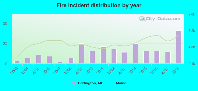 According to the data from the years 2003 - 2018 the average number of fires per year is 15. The highest number of reported fire incidents - 41 took place in 2018, and the least - 2 in 2007. The data has a growing trend.
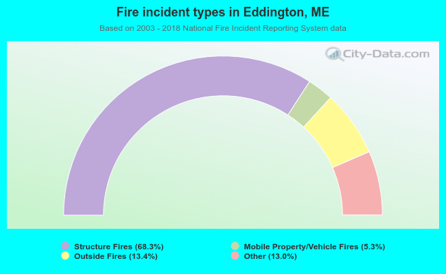 When looking into fire subcategories, the most incidents belonged to: Structure Fires (68.3%), and Outside Fires (13.4%).
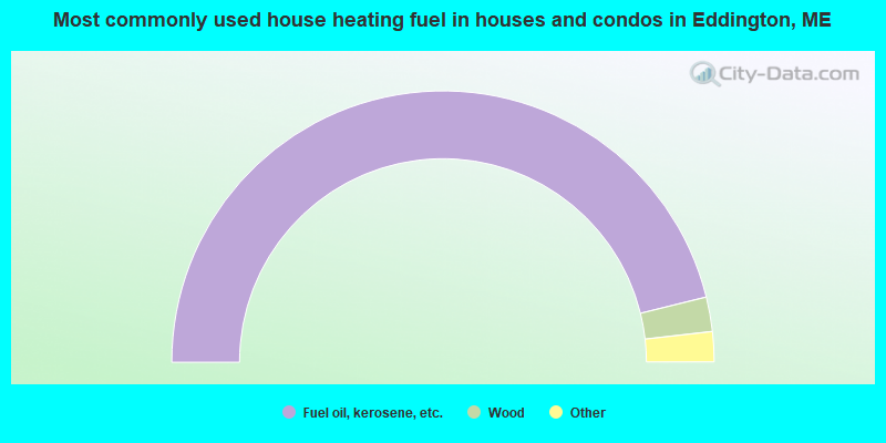
- 92.3%Fuel oil, kerosene, etc.
- 4.1%Wood
- 2.4%Bottled, tank, or LP gas
- 0.9%Electricity
- 0.3%Coal or coke
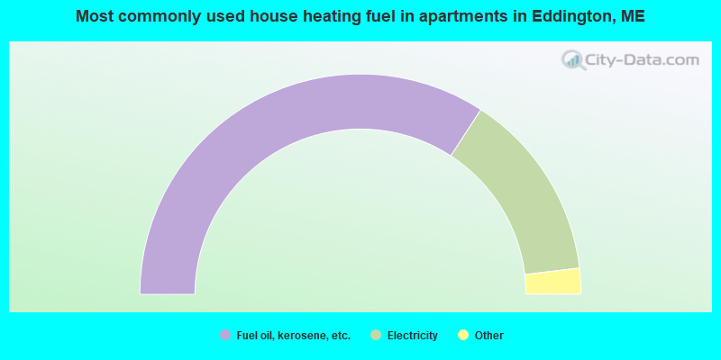
- 68.4%Fuel oil, kerosene, etc.
- 27.8%Electricity
- 1.9%Bottled, tank, or LP gas
- 1.3%Wood
- 0.6%Other fuel
Eddington compared to Maine state average:
- Unemployed percentage below state average.
- Black race population percentage below state average.
- Hispanic race population percentage significantly below state average.
- Foreign-born population percentage below state average.
- Renting percentage below state average.
- Length of stay since moving in significantly above state average.
- Number of rooms per house significantly below state average.
- House age significantly below state average.
Eddington on our top lists:
- #36 on the list of "Top 100 safest cities (lowest city-data.com crime index)"
- #26 on the list of "Top 101 counties with the highest percentage of residents that smoked 100+ cigarettes in their lives"
- #27 on the list of "Top 101 counties with the highest percentage of residents that drank alcohol in the past 30 days"
- #28 on the list of "Top 101 counties with highest percentage of residents voting for 3rd party candidates in the 2012 Presidential Election (pop. 50,000+)"
- #42 on the list of "Top 101 counties with the lowest number of births per 1000 residents 2007-2013"
- #44 on the list of "Top 101 counties with the lowest percentage of residents relocating to foreign countries in 2011 (pop. 50,000+)"

|
Total of 6 patent applications in 2008-2024.