Eaton, Indiana
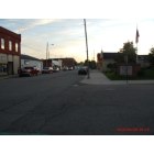
Eaton: view down harris street
Eaton: Eaton
Eaton: Our Local fun Bar
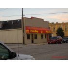
Eaton: Eaton's Pizza King.....Love there Bread Sticks
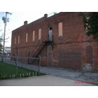
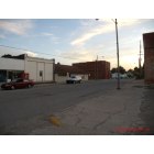
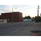
Eaton: The Old fire station building from side
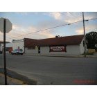
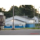
Eaton: The new small town store and video's...
Eaton: Eaton

Eaton: My home...flowers on porch..harris street
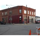
Eaton: Old corner store...on harris
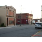
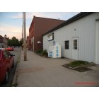
Eaton: view from harris street
Eaton: Eaton
- see
23
more - add
your


Submit your own pictures of this town and show them to the world
- OSM Map
- General Map
- Google Map
- MSN Map

Population change since 2000: -0.7%
 |
| Males: 846 | |
| Females: 746 |
| Median resident age: | 36.4 years |
| Indiana median age: | 38.2 years |
| Eaton: | $46,661 |
| IN: | $66,785 |
Estimated per capita income in 2022: $27,804 (it was $13,833 in 2000)
Eaton town income, earnings, and wages data
Estimated median house or condo value in 2022: $87,791 (it was $50,900 in 2000)
| Eaton: | $87,791 |
| IN: | $208,700 |
Mean prices in 2022: all housing units: $148,206; detached houses: $152,675; townhouses or other attached units: $149,312; in 2-unit structures: $159,501; in 3-to-4-unit structures: $158,779; in 5-or-more-unit structures: $271,240; mobile homes: $40,677
Median gross rent in 2022: $693.
(13.7% for White Non-Hispanic residents, 4.1% for two or more races residents)
Detailed information about poverty and poor residents in Eaton, IN
Compare current foreclosures near Eaton, IN:
| Photo | Address | Area | Beds / Baths | Price | Details |
|---|---|---|---|---|---|

|
#1
E Eaton Albany Pike
Eaton, IN 47338
|
2,213 sq. feet
|
2 baths 2 beds |
show details | |

|
#2
E Indiana Ave
Eaton, IN 47338
|
1,396 sq. feet
|
1 baths 4 beds |
show details | |

|
#3
W Indiana Ave
Eaton, IN 47338
|
1,776 sq. feet
|
1 baths 3 beds |
show details | |

|
#4
Hartford St
Eaton, IN 47338
|
- sq. feet
|
- baths - beds |
show details | |

|
#5
E County Road 800 N
Eaton, IN 47338
|
- sq. feet
|
- baths - beds |
show details | |

|
#6
S Liberty St
Eaton, IN 47338
|
- sq. feet
|
- baths - beds |
show details | |

|
#7
S Whitney Rd
Selma, IN 47383
|
1,952 sq. feet
|
2 baths 3 beds |
$69,000
|
show details |

|
#8
W 10th St
Muncie, IN 47302
|
1,608 sq. feet
|
1 baths 2 beds |
$91,500
|
show details |

|
#9
West 500 North
Gaston, IN 47342
|
1,736 sq. feet
|
1 baths 3 beds |
$214,900
|
show details |

|
#10
E Wabash Ave
Muncie, IN 47303
|
1,400 sq. feet
|
1 baths 3 beds |
$158,900
|
show details |
| Photo | Address | Area | Beds / Baths | Price | Details |
|---|---|---|---|---|---|

|
#11
E New York St
Summitville, IN 46070
|
- sq. feet
|
1 baths 2 beds |
$1
|
show details |

|
#12
E S G
Gas City, IN 46933
|
1,256 sq. feet
|
1 baths - beds |
$19,900
|
show details |

|
#13
S Us Highway 35
Selma, IN 47383
|
2,218 sq. feet
|
2 baths 3 beds |
show details | |

|
#14
S Jefferson St
Hartford City, IN 47348
|
2,440 sq. feet
|
1 baths 3 beds |
show details | |

|
#15
S Walling Ave
Muncie, IN 47302
|
1,354 sq. feet
|
1 baths 3 beds |
show details | |

|
#16
N 10th St
Gas City, IN 46933
|
1,568 sq. feet
|
1 baths 3 beds |
show details | |

|
#17
E Main St
Gas City, IN 46933
|
- sq. feet
|
2 baths 3 beds |
show details | |

|
#18
N Fulton St
Parker City, IN 47368
|
1,328 sq. feet
|
1 baths 2 beds |
show details | |

|
#19
S Manhattan Ave
Muncie, IN 47302
|
728 sq. feet
|
1 baths 2 beds |
show details | |

|
#20
S State Road 3 Apt 26
Hartford City, IN 47348
|
1,064 sq. feet
|
1 baths 2 beds |
show details |
| Photo | Address | Area | Beds / Baths | Price | Details |
|---|---|---|---|---|---|

|
#21
E Jackson St
Muncie, IN 47303
|
1,211 sq. feet
|
1 baths 2 beds |
show details | |

|
#22
1010 18
Hartford City, IN 47348
|
888 sq. feet
|
1 baths 1 beds |
show details | |

|
#23
New York St
Farmland, IN 47340
|
- sq. feet
|
1 baths 3 beds |
show details | |

|
#24
E 5th St
Muncie, IN 47302
|
- sq. feet
|
- baths - beds |
$59,900
|
show details |

|
#25
E 1st St
Fowlerton, IN 46930
|
1,640 sq. feet
|
1 baths 2 beds |
show details | |

|
#26
W Kings Row St
Muncie, IN 47304
|
2,000 sq. feet
|
2 baths 3 beds |
show details | |

|
#27
W Hellis Dr
Muncie, IN 47304
|
1,862 sq. feet
|
2 baths 4 beds |
show details | |

|
#28
E Washington St
Parker City, IN 47368
|
704 sq. feet
|
1 baths 2 beds |
show details | |

|
#29
E South D St
Gas City, IN 46933
|
1,808 sq. feet
|
1 baths 3 beds |
show details | |

|
#30
N Greenbriar Rd
Muncie, IN 47304
|
2,658 sq. feet
|
2 baths 3 beds |
show details |
| Photo | Address | Area | Beds / Baths | Price | Details |
|---|---|---|---|---|---|

|
#31
S Beacon St
Muncie, IN 47302
|
1,197 sq. feet
|
1 baths 2 beds |
show details | |

|
#32
N County Road 850 W
Yorktown, IN 47396
|
816 sq. feet
|
1 baths 2 beds |
show details | |

|
#33
W University Ave
Muncie, IN 47303
|
2,815 sq. feet
|
2 baths 5 beds |
show details | |

|
#34
W River Rd
Yorktown, IN 47396
|
2,410 sq. feet
|
1 baths 2 beds |
show details | |

|
#35
E Washington St
Muncie, IN 47305
|
1,056 sq. feet
|
1 baths 2 beds |
show details | |

|
#36
E Kirby Ave
Muncie, IN 47302
|
1,472 sq. feet
|
1 baths 4 beds |
show details | |

|
#37
S Macedonia Ave
Muncie, IN 47302
|
1,948 sq. feet
|
2 baths 3 beds |
show details | |

|
#38
E Robert St
Muncie, IN 47303
|
975 sq. feet
|
1 baths 3 beds |
show details | |

|
#39
W Torquay Rd
Muncie, IN 47304
|
840 sq. feet
|
1 baths 2 beds |
show details | |

|
#40
E Main St
Muncie, IN 47305
|
2,330 sq. feet
|
1 baths 4 beds |
show details |
| Photo | Address | Area | Beds / Baths | Price | Details |
|---|---|---|---|---|---|

|
#41
N Waldemere Ave
Muncie, IN 47303
|
1,416 sq. feet
|
2 baths 2 beds |
show details | |

|
#42
S 1000 W
Redkey, IN 47373
|
1,176 sq. feet
|
2 baths 3 beds |
show details | |

|
#43
N Alden Rd
Muncie, IN 47304
|
1,187 sq. feet
|
3 baths 4 beds |
show details | |

|
#44
N 200 W
Hartford City, IN 47348
|
1,248 sq. feet
|
2 baths 3 beds |
show details | |

|
#45
S Walnut St
Yorktown, IN 47396
|
1,642 sq. feet
|
1 baths 3 beds |
show details | |

|
#46
W Cade Cir
Muncie, IN 47304
|
1,400 sq. feet
|
1 baths 3 beds |
show details | |

|
#47
N Gavin St
Muncie, IN 47303
|
1,432 sq. feet
|
1 baths 3 beds |
show details | |

|
#48
N Lafayette Dr
Muncie, IN 47303
|
2,311 sq. feet
|
2 baths 3 beds |
show details | |

|
#49
N Forest Ave
Muncie, IN 47304
|
2,664 sq. feet
|
2 baths 4 beds |
show details | |

|
Check over 1 million property listings on Foreclosure.com!
|
browse all offers | |||


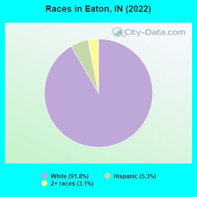
- 1,54791.8%White alone
- 895.3%Hispanic
- 523.1%Two or more races
Races in Eaton detailed stats: ancestries, foreign born residents, place of birth
 Recent articles from our blog. Our writers, many of them Ph.D. graduates or candidates, create easy-to-read articles on a wide variety of topics.


 | Can someone please offer comments about Richmond IN? (11 replies) |
| Indiana vs Iowa (8 replies) |
| traveling through Indiana (10 replies) |
| Doughnut Syndrom (16 replies) |
| Can anyone tell me about Ridgeville, IN?? (1 reply) |
Latest news from Eaton, IN collected exclusively by city-data.com from local newspapers, TV, and radio stations
Ancestries: American (26.0%), English (21.1%), German (10.2%), Irish (7.4%), European (5.7%), Scandinavian (4.2%).
Current Local Time: EST time zone
Elevation: 914 feet
Land area: 1.12 square miles.
Population density: 1,422 people per square mile (low).
13 residents are foreign born
| This town: | 0.8% |
| Indiana: | 3.1% |
Median real estate property taxes paid for housing units with mortgages in 2022: $677 (0.7%)
Median real estate property taxes paid for housing units with no mortgage in 2022: $625 (0.8%)
Nearest city with pop. 50,000+: Muncie, IN  (10.3 miles , pop. 67,430).
Nearest city with pop. 200,000+: Fort Wayne, IN (52.5 miles , pop. 205,727).
Nearest city with pop. 1,000,000+: Chicago, IL (159.6 miles , pop. 2,896,016).
Nearest cities:
), ), Latitude: 40.34 N, Longitude: 85.35 W
Area code: 765
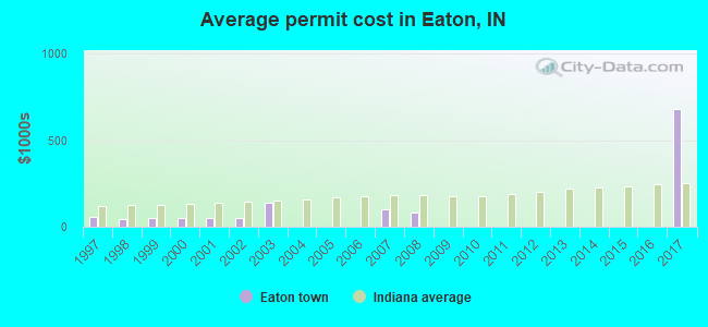
Single-family new house construction building permits:
- 2017: 2 buildings, average cost: $680,000
- 2008: 2 buildings, average cost: $82,500
- 2007: 1 building, cost: $103,000
- 2003: 1 building, cost: $140,000
- 2002: 2 buildings, average cost: $53,300
- 2001: 2 buildings, average cost: $53,300
- 2000: 2 buildings, average cost: $53,300
- 1999: 3 buildings, average cost: $53,300
- 1998: 7 buildings, average cost: $45,000
- 1997: 3 buildings, average cost: $57,700
| Here: | 3.2% |
| Indiana: | 2.8% |
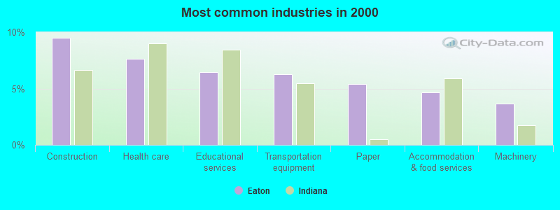
- Construction (9.5%)
- Health care (7.6%)
- Educational services (6.4%)
- Transportation equipment (6.3%)
- Paper (5.4%)
- Accommodation & food services (4.7%)
- Machinery (3.7%)
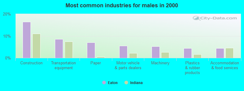
- Construction (16.4%)
- Transportation equipment (8.6%)
- Paper (7.0%)
- Motor vehicle & parts dealers (5.5%)
- Machinery (5.2%)
- Plastics & rubber products (4.4%)
- Accommodation & food services (4.4%)
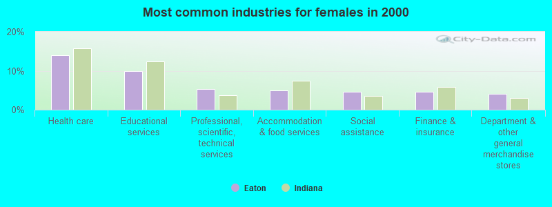
- Health care (14.0%)
- Educational services (10.0%)
- Professional, scientific, technical services (5.3%)
- Accommodation & food services (5.0%)
- Social assistance (4.7%)
- Finance & insurance (4.7%)
- Department & other general merchandise stores (4.0%)
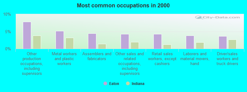
- Other production occupations, including supervisors (7.8%)
- Metal workers and plastic workers (5.1%)
- Assemblers and fabricators (4.4%)
- Other sales and related occupations, including supervisors (4.2%)
- Retail sales workers, except cashiers (4.2%)
- Laborers and material movers, hand (3.8%)
- Driver/sales workers and truck drivers (3.7%)
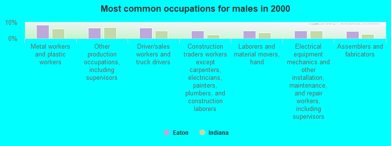
- Metal workers and plastic workers (8.4%)
- Other production occupations, including supervisors (6.5%)
- Driver/sales workers and truck drivers (6.5%)
- Construction traders workers except carpenters, electricians, painters, plumbers, and construction laborers (5.0%)
- Laborers and material movers, hand (4.7%)
- Electrical equipment mechanics and other installation, maintenance, and repair workers, including supervisors (4.7%)
- Assemblers and fabricators (4.4%)
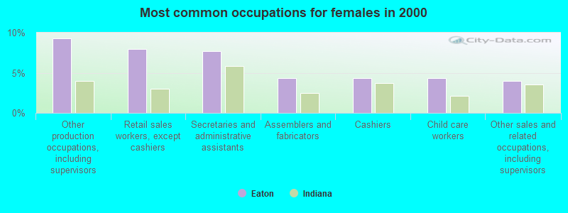
- Other production occupations, including supervisors (9.3%)
- Retail sales workers, except cashiers (8.0%)
- Secretaries and administrative assistants (7.7%)
- Assemblers and fabricators (4.3%)
- Cashiers (4.3%)
- Child care workers (4.3%)
- Other sales and related occupations, including supervisors (4.0%)
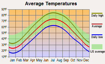
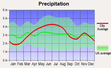
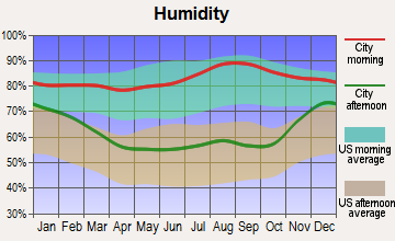
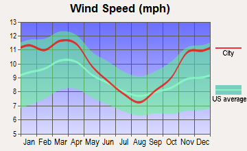
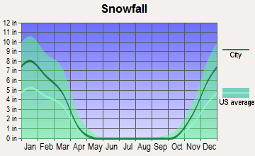
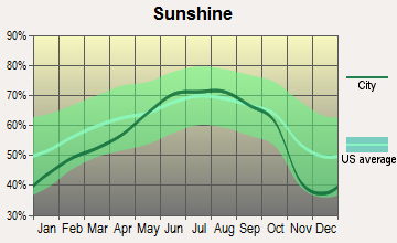
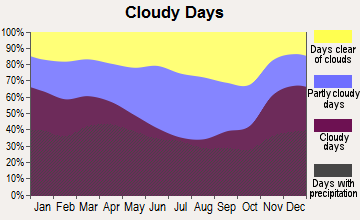
Average climate in Eaton, Indiana
Based on data reported by over 4,000 weather stations
(lower is better)
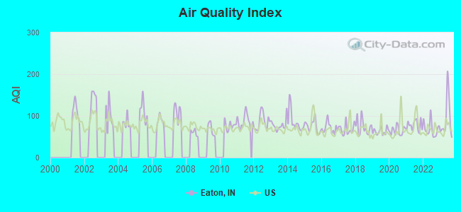
Air Quality Index (AQI) level in 2023 was 93.8. This is worse than average.
| City: | 93.8 |
| U.S.: | 72.6 |
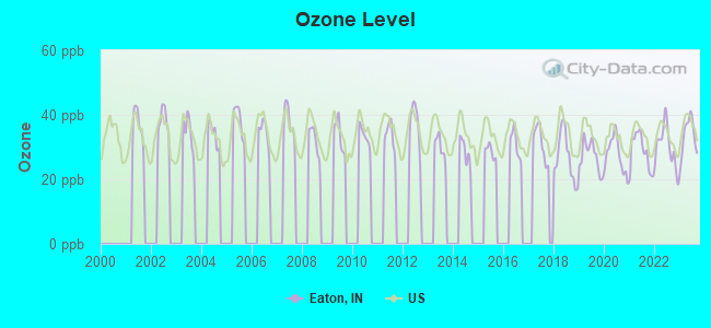
Ozone [ppb] level in 2023 was 33.3. This is about average. Closest monitor was 6.3 miles away from the city center.
| City: | 33.3 |
| U.S.: | 33.3 |
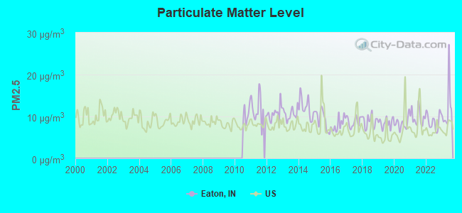
Particulate Matter (PM2.5) [µg/m3] level in 2023 was 12.0. This is significantly worse than average. Closest monitor was 9.9 miles away from the city center.
| City: | 12.0 |
| U.S.: | 8.1 |
Tornado activity:
Eaton-area historical tornado activity is slightly above Indiana state average. It is 111% greater than the overall U.S. average.
On 4/11/1965, a category F4 (max. wind speeds 207-260 mph) tornado 13.9 miles away from the Eaton town center killed 25 people and injured 835 people and caused between $50,000,000 and $500,000,000 in damages.
On 4/11/1965, a category F4 tornado 14.6 miles away from the town center killed 4 people and injured 125 people and caused between $5,000,000 and $50,000,000 in damages.
Earthquake activity:
Eaton-area historical earthquake activity is significantly above Indiana state average. It is 21% greater than the overall U.S. average.On 4/18/2008 at 09:36:59, a magnitude 5.4 (5.1 MB, 4.8 MS, 5.4 MW, 5.2 MW, Class: Moderate, Intensity: VI - VII) earthquake occurred 188.0 miles away from Eaton center
On 7/27/1980 at 18:52:21, a magnitude 5.2 (5.1 MB, 4.7 MS, 5.0 UK, 5.2 UK) earthquake occurred 165.8 miles away from the city center
On 4/18/2008 at 09:36:59, a magnitude 5.2 (5.2 MW, Depth: 8.9 mi) earthquake occurred 188.1 miles away from the city center
On 6/10/1987 at 23:48:54, a magnitude 5.1 (4.9 MB, 4.4 MS, 4.6 MS, 5.1 LG) earthquake occurred 171.0 miles away from Eaton center
On 7/12/1986 at 08:19:37, a magnitude 4.5 (4.5 MB, Class: Light, Intensity: IV - V) earthquake occurred 53.5 miles away from the city center
On 6/18/2002 at 17:37:15, a magnitude 5.0 (4.3 MB, 4.6 MW, 5.0 LG) earthquake occurred 208.3 miles away from the city center
Magnitude types: regional Lg-wave magnitude (LG), body-wave magnitude (MB), surface-wave magnitude (MS), moment magnitude (MW)
Natural disasters:
The number of natural disasters in Delaware County (15) is near the US average (15).Major Disasters (Presidential) Declared: 10
Emergencies Declared: 4
Causes of natural disasters: Storms: 7, Floods: 6, Tornadoes: 6, Snows: 2, Winter Storms: 2, Blizzard: 1, Hurricane: 1, Ice Storm: 1, Other: 1 (Note: some incidents may be assigned to more than one category).

Hospitals and medical centers near Eaton:
- ALBANY HEALTH CARE, INC (Nursing Home, about 7 miles away; ALBANY, IN)
- MILLER'S MERRY MANOR (Nursing Home, about 8 miles away; HARTFORD CITY, IN)
- HICKORY CREEK AT GASTON (Hospital, about 8 miles away; GASTON, IN)
- KINDRED TRANSITIONAL CARE AND REHAB-MUNCIE (Nursing Home, about 8 miles away; MUNCIE, IN)
- MUNCIE HEALTH CARE CENTER (Nursing Home, about 8 miles away; MUNCIE, IN)
- BRIDGEWATER REHABILITATION CENTRE (Nursing Home, about 9 miles away; HARTFORD CITY, IN)
- HARTFORD CITY COMMUNITY CARE CENTER (Nursing Home, about 9 miles away; HARTFORD CITY, IN)
Airports located in Eaton:
- Horizon Field Airport (IN63) (Runways: 1)
Colleges/universities with over 2000 students nearest to Eaton:
- Ball State University (about 11 miles; Muncie, IN; Full-time enrollment: 20,254)
- Taylor University (about 12 miles; Upland, IN; FT enrollment: 2,272)
- Indiana Wesleyan University (about 21 miles; Marion, IN; FT enrollment: 13,681)
- Anderson University (about 23 miles; Anderson, IN; FT enrollment: 2,378)
- Indiana University-East (about 41 miles; Richmond, IN; FT enrollment: 2,867)
- Indiana University-Kokomo (about 42 miles; Kokomo, IN; FT enrollment: 2,500)
- Indiana Institute of Technology (about 53 miles; Fort Wayne, IN; FT enrollment: 4,320)
Public elementary/middle school in Eaton:
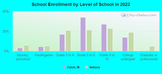
- EATON ELEMENTARY SCHOOL (Students: 271, Location: 200 N E UNION ST, Grades: KG-5)
Points of interest:
Drinking water stations with addresses in Eaton and their reported violations in the past:
EATON WATER WORKS (Population served: 1,805, Groundwater):Past monitoring violations:
- One regular monitoring violation
| This town: | 2.6 people |
| Indiana: | 2.5 people |
| This town: | 73.0% |
| Whole state: | 66.9% |
| This town: | 6.9% |
| Whole state: | 6.9% |
Likely homosexual households (counted as self-reported same-sex unmarried-partner households)
- Lesbian couples: 0.3% of all households
- Gay men: 0.1% of all households
Banks with branches in Eaton (2011 data):
- First Merchants Bank National Association: Eaton at 107 East Harris Street, branch established on 1953/08/10. Info updated 2012/02/13: Bank assets: $4,154.9 mil, Deposits: $3,154.7 mil, headquarters in Muncie, IN, positive income, Commercial Lending Specialization, 89 total offices, Holding Company: First Merchants Corporation
For population 15 years and over in Eaton:
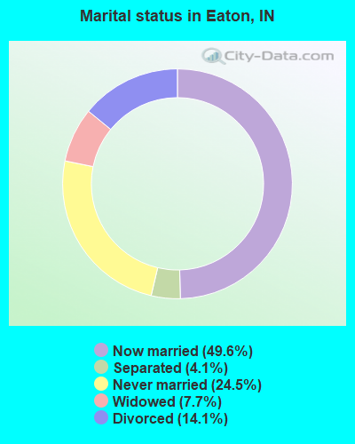
- Never married: 24.5%
- Now married: 49.6%
- Separated: 4.1%
- Widowed: 7.7%
- Divorced: 14.1%
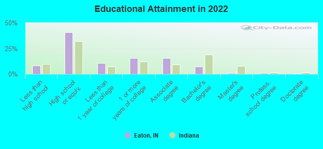
For population 25 years and over in Eaton:
- High school or higher: 90.3%
- Bachelor's degree or higher: 9.6%
- Graduate or professional degree: 2.5%
- Unemployed: 7.1%
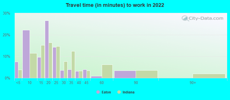
- Mean travel time to work (commute): 27.3 minutes
| Here: | 7.6 |
| Indiana average: | 11.3 |
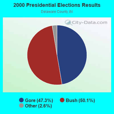
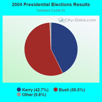
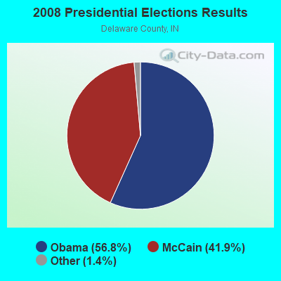
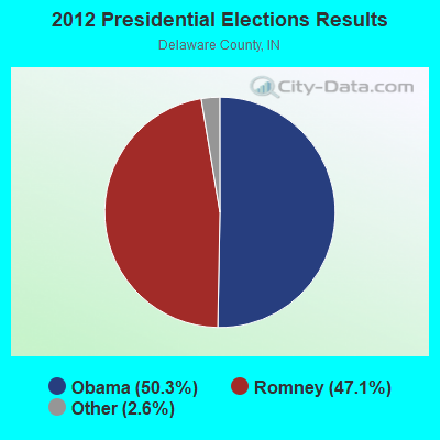
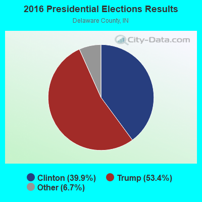
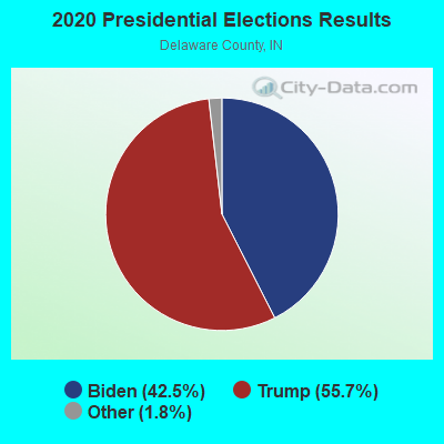
Graphs represent county-level data. Detailed 2008 Election Results
Religion statistics for Eaton, IN (based on Delaware County data)
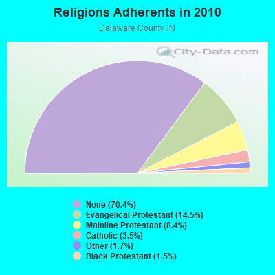
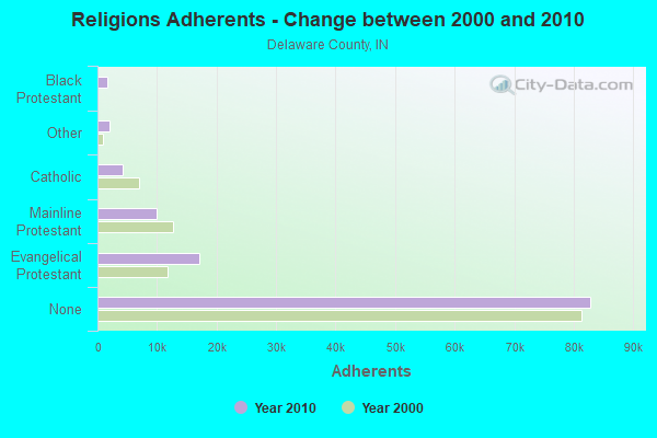
| Religion | Adherents | Congregations |
|---|---|---|
| Evangelical Protestant | 17,042 | 98 |
| Mainline Protestant | 9,876 | 40 |
| Catholic | 4,171 | 3 |
| Other | 1,992 | 7 |
| Black Protestant | 1,741 | 9 |
| None | 82,849 | - |
Food Environment Statistics:
| Delaware County: | 1.30 / 10,000 pop. |
| Indiana: | 1.73 / 10,000 pop. |
| Delaware County: | 0.17 / 10,000 pop. |
| Indiana: | 0.21 / 10,000 pop. |
| Here: | 0.52 / 10,000 pop. |
| Indiana: | 0.50 / 10,000 pop. |
| Here: | 4.52 / 10,000 pop. |
| Indiana: | 3.57 / 10,000 pop. |
| This county: | 6.77 / 10,000 pop. |
| State: | 6.78 / 10,000 pop. |
| Delaware County: | 10.0% |
| State: | 9.2% |
| Delaware County: | 31.3% |
| State: | 29.0% |
| Delaware County: | 11.9% |
| Indiana: | 14.3% |
Health and Nutrition:
| Eaton: | 44.2% |
| Indiana: | 49.3% |
| Eaton: | 34.1% |
| State: | 46.2% |
| Here: | 27.6 |
| State: | 28.7 |
| This city: | 16.8% |
| Indiana: | 21.3% |
| Eaton: | 6.9% |
| State: | 10.6% |
| This city: | 6.7 |
| State: | 6.8 |
| Eaton: | 26.5% |
| State: | 33.9% |
| Eaton: | 50.7% |
| State: | 56.1% |
| This city: | 73.5% |
| Indiana: | 78.7% |
More about Health and Nutrition of Eaton, IN Residents
| Local government employment and payroll (March 2022) | |||||
| Function | Full-time employees | Monthly full-time payroll | Average yearly full-time wage | Part-time employees | Monthly part-time payroll |
|---|---|---|---|---|---|
| Sewerage | 4 | $9,451 | $28,353 | 0 | $0 |
| Police Protection - Officers | 4 | $15,208 | $45,624 | 0 | $0 |
| Water Supply | 3 | $5,558 | $22,232 | 0 | $0 |
| Financial Administration | 1 | $4,114 | $49,368 | 0 | $0 |
| Streets and Highways | 1 | $1,435 | $17,220 | 0 | $0 |
| Firefighters | 1 | $2,843 | $34,116 | 0 | $0 |
| Parks and Recreation | 0 | $0 | 1 | $638 | |
| Totals for Government | 14 | $38,608 | $33,093 | 1 | $638 |
Eaton government finances - Expenditure in 2017 (per resident):
- Construction - Sewerage: $235,000 ($147.61)
- Current Operations - General - Other: $368,000 ($231.16)
Police Protection: $211,000 ($132.54)
Water Utilities: $204,000 ($128.14)
Sewerage: $202,000 ($126.88)
Central Staff Services: $163,000 ($102.39)
Regular Highways: $87,000 ($54.65)
Local Fire Protection: $76,000 ($47.74)
- General - Interest on Debt: $44,000 ($27.64)
- Other Capital Outlay - Central Staff Services: $59,000 ($37.06)
Local Fire Protection: $50,000 ($31.41)
Police Protection: $45,000 ($28.27)
Eaton government finances - Revenue in 2017 (per resident):
- Charges - Sewerage: $871,000 ($547.11)
Solid Waste Management: $89,000 ($55.90)
- Federal Intergovernmental - Other: $5,000 ($3.14)
- Local Intergovernmental - Other: $21,000 ($13.19)
Highways: $15,000 ($9.42)
- Miscellaneous - Fines and Forfeits: $16,000 ($10.05)
Rents: $7,000 ($4.40)
Donations From Private Sources: $5,000 ($3.14)
General Revenue - Other: $5,000 ($3.14)
Interest Earnings: $1,000 ($0.63)
- Revenue - Water Utilities: $421,000 ($264.45)
- State Intergovernmental - Highways: $121,000 ($76.01)
Other: $56,000 ($35.18)
General Local Government Support: $54,000 ($33.92)
Water Utilities: $11,000 ($6.91)
- Tax - Property: $389,000 ($244.35)
Other License: $3,000 ($1.88)
Eaton government finances - Debt in 2017 (per resident):
- Long Term Debt - Beginning Outstanding - Unspecified Public Purpose: $912,000 ($572.86)
Outstanding Unspecified Public Purpose: $912,000 ($572.86)
Eaton government finances - Cash and Securities in 2017 (per resident):
- Bond Funds - Cash and Securities: $146,000 ($91.71)
- Other Funds - Cash and Securities: $1,534,000 ($963.57)
- Sinking Funds - Cash and Securities: $139,000 ($87.31)
Strongest AM radio stations in Eaton:
- WOWO (1190 AM; 50 kW; FORT WAYNE, IN; Owner: PATHFINDER COMMUNICATIONS CORPORATION)
- WIBC (1070 AM; 50 kW; INDIANAPOLIS, IN; Owner: EMMIS RADIO LICENSE CORPORATION)
- WLW (700 AM; 50 kW; CINCINNATI, OH; Owner: JACOR BROADCASTING CORPORATION)
- WXFN (1340 AM; 1 kW; MUNCIE, IN; Owner: MUNCIE SABRECOM, INC.)
- WTVN (610 AM; 50 kW; COLUMBUS, OH; Owner: CITICASTERS LICENSES, L.P.)
- WSAI (1530 AM; 50 kW; CINCINNATI, OH; Owner: JACOR BROADCASTING CORPORATION)
- WHAS (840 AM; 50 kW; LOUISVILLE, KY; Owner: CLEAR CHANNEL BROADCASTING LICENSES, INC.)
- WGOM (860 AM; 1 kW; MARION, IN; Owner: MID-AMERICA RADIO OF INDIANA, INC.)
- WIOU (1350 AM; 5 kW; KOKOMO, IN; Owner: MID-AMERICA RADIO GROUP, INC.)
- WLS (890 AM; 50 kW; CHICAGO, IL; Owner: WLS, INC.)
- WJR (760 AM; 50 kW; DETROIT, MI; Owner: ABC, INC.)
- WSCR (670 AM; 50 kW; CHICAGO, IL; Owner: INFINITY BROADCASTING OPERATIONS, INC.)
- WFDF (910 AM; 50 kW; FLINT, MI; Owner: ABC, INC.)
Strongest FM radio stations in Eaton:
- WHTY (93.5 FM; HARTFORD CITY, IN; Owner: INDIANA SABRECOM, INC.)
- WWDS (90.5 FM; MUNCIE, IN; Owner: DELAWARE COMMUNITY SCHOOL CORP.)
- WLBC-FM (104.1 FM; MUNCIE, IN; Owner: MUNCIE SABRECOM, INC.)
- WBST (92.1 FM; MUNCIE, IN; Owner: BALL STATE UNIVERSITY)
- WERK (104.9 FM; MUNCIE, IN; Owner: INDIANA SABRECOM, INC.)
- WMDH-FM (102.5 FM; NEW CASTLE, IN; Owner: CITADEL BROADCASTING COMPANY)
- WMRI (106.9 FM; MARION, IN; Owner: MID-AMERICA RADIO OF INDIANA, INC.)
- WHTI (96.7 FM; ALEXANDRIA, IN; Owner: INDIANA SABRECOM, INC.)
- WBSB (89.5 FM; ANDERSON, IN; Owner: BALL STATE UNIVERSITY)
- WGNR-FM (97.9 FM; ANDERSON, IN; Owner: THE MOODY BIBLE INSTITUTE OF CHICAGO)
- WTUR (89.7 FM; UPLAND, IN; Owner: TAYLOR UNIVERSITY, INC.)
- WBSJ (91.7 FM; PORTLAND, IN; Owner: BALL STATE UNIVERSITY)
- WQME (98.7 FM; ANDERSON, IN; Owner: ANDERSON UNIVERSITY, INC.)
- W291AH (106.1 FM; MUNCIE, IN; Owner: TAYLOR UNIVERSITY BROADCASTING, INC.)
- WPGW-FM (100.9 FM; PORTLAND, IN; Owner: WPGW, INC.)
- WHCI (88.1 FM; HARTFORD CITY, IN; Owner: BLACKFORD COUNTY SCHOOL CORPORATION)
TV broadcast stations around Eaton:
- WIPB (Channel 49; MUNCIE, IN; Owner: BALL STATE UNIVERSITY)
- WTTK (Channel 29; KOKOMO, IN; Owner: TRIBUNE BROADCAST HOLDINGS, INC.)
- WNDY-TV (Channel 23; MARION, IN; Owner: UPN STATIONS GROUP INC.)
- WIWU-LP (Channel 51; MARION, IN; Owner: IWU COMMUNICATIONS, INC.)
- WSOT-LP (Channel 57; MARION, IN; Owner: SUNNYCREST MEDIA, INC.)
- WMUN-LP (Channel 26; MUNCIE, IN; Owner: FULL GOSPEL FELLOWSHIP, MUNCIE IND.)
Eaton fatal accident list:
Aug 19, 2015 07:25 AM, Sr- 3, Cr- 800, Lat: 40.306067, Lon: -85.368750, Vehicles: 2, Persons: 2, Fatalities: 1
Nov 1, 2014 05:51 PM, Sr-3, Lat: 40.350686, Lon: -85.369519, Vehicles: 1, Persons: 1, Fatalities: 1
Oct 5, 2010 07:54 AM, Eaton Wheeling Pike, Lat: 40.354917, Lon: -85.441703, Vehicles: 1, Persons: 1, Fatalities: 1
Apr 7, 2008 01:23 PM, Sr-3, Cr-1000, Lat: 40.334960, Lon: -85.369520, Vehicles: 3, Persons: 3, Fatalities: 1
Jun 21, 2007 03:50 PM, Sr-3, Indiana Avenue, Lat: 40.345728, Lon: -85.369547, Vehicles: 3, Persons: 2, Fatalities: 1
Oct 26, 2007 10:41 PM, Sr-3, Cr-800, Lat: 40.306050, Lon: -85.368756, Vehicles: 2, Persons: 2, Fatalities: 1
- National Bridge Inventory (NBI) Statistics
- 45Number of bridges
- 561ft / 171mTotal length
- $4,636,000Total costs
- 225,280Total average daily traffic
- 33,616Total average daily truck traffic
- 349,411Total future (year 2029) average daily traffic
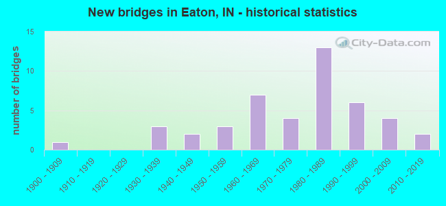
- New bridges - historical statistics
- 11900-1909
- 31930-1939
- 21940-1949
- 31950-1959
- 71960-1969
- 41970-1979
- 131980-1989
- 61990-1999
- 42000-2009
- 22010-2019
FCC Registered Cell Phone Towers:
1 (See the full list of FCC Registered Cell Phone Towers in Eaton)FCC Registered Antenna Towers:
27 (See the full list of FCC Registered Antenna Towers)FCC Registered Broadcast Land Mobile Towers:
7- 108 E Harris St (Lat: 40.345333 Lon: -85.369972), Call Sign: KNJD367,
Assigned Frequencies: 154.190 MHz, Grant Date: 07/08/2014, Expiration Date: 08/14/2024, Registrant: Tnt Electronics, 4639 N Sr 1, Farmland, IN 47340, Phone: (765) 468-7470, Email:
- 1 Mi E Of State Rd 3 1/2 Mi S Of (Lat: 40.335333 Lon: -85.361917), Call Sign: WHS84, Licensee ID: L00154806,
Assigned Frequencies: 173.396 MHz, Grant Date: 08/06/1996, Expiration Date: 08/06/2001, Cancellation Date: 07/02/2001, Registrant: Indiana Michigan Power Company Dba American Electric Power, 1 Riverside Plaza, Columbus, OH 43215-2373, Phone: (219) 425-2275
- Rtu2: N Of Wasington Street Between Meridan (Lat: 40.344444 Lon: -85.349444), Type: Tank, Structure height: 15 m, Call Sign: WPUR973,
Assigned Frequencies: 153.695 MHz, Grant Date: 04/14/2022, Expiration Date: 04/22/2032, Certifier: Allen L Ashcraft, Registrant: Town Of Eaton, 107 E Harris St, Eaton, IN 47338, Phone: (765) 396-3980, Fax: (765) 396-3984, Email:
- MOBILE L2, Lat: 40.341583 Lon: -85.357861, Call Sign: WQDW461,
Assigned Frequencies: 161.355 MHz, 160.575 MHz, Grant Date: 08/18/2015, Expiration Date: 11/15/2025, Certifier: Jerry R Celio, Registrant: Norfolk Southern Railway Company, 1200 Peachtree Street Ne / Box 123, Atlanta, GA 30309, Phone: (404) 582-6224, Fax: (404) 582-6209, Email:
- Lat: 40.333389 Lon: -85.354139, Call Sign: WQFE352,
Assigned Frequencies: 153.215 MHz, Grant Date: 04/15/2016, Expiration Date: 06/26/2026, Certifier: Donald P Finnegan, Registrant: Westrock Eaton Mill, 800a South Romy, Eaton, IN 47338, Phone: (765) 396-3317, Email:
- Lat: 40.308333 Lon: -85.360972, Call Sign: WQVF868,
Assigned Frequencies: 462.075 MHz, 463.250 MHz, 464.275 MHz, 464.000 MHz, Grant Date: 01/29/2015, Expiration Date: 01/29/2025, Certifier: David Schnepf, Registrant: National License, 12591 Brompton Road, Carmel, IN 46033, Phone: (317) 564-8018, Email:
- Lat: 40.336417 Lon: -85.354750, Call Sign: WRFI994,
Assigned Frequencies: 451.387 MHz, 451.637 MHz, 452.662 MHz, 456.387 MHz, 457.662 MHz, Grant Date: 03/12/2020, Expiration Date: 03/12/2030, Certifier: Sherri Schnepp, Registrant: Mobile Communications America, 1201 Crutchfield St, Chattanooga, TN 37406, Phone: (423) 698-3306, Fax: (423) 698-0446, Email:
FCC Registered Microwave Towers:
3- Curless, Off Of N Wabash Ave (Lat: 40.747306 Lon: -85.756056), Type: Silo, Structure height: 36.5 m, Overall height: 37.5 m, Call Sign: WRAL262,
Assigned Frequencies: 11245.0 MHz, 11245.0 MHz, 11485.0 MHz, 11485.0 MHz, 11245.0 MHz, 11245.0 MHz, 11485.0 MHz, 11485.0 MHz, 11245.0 MHz, 11245.0 MHz... (+6 more), Grant Date: 12/20/2017, Expiration Date: 12/20/2027, Certifier: Doug Brown, Registrant: Intelpath, Hinsdale, IL 60522, Phone: (312) 841-9188, Email:
- EATON, 2330 E Ashcraft St (Lat: 40.307694 Lon: -85.361000), Type: Silo, Structure height: 33 m, Overall height: 34 m, Call Sign: WRJG330,
Assigned Frequencies: 11325.0 MHz, 11325.0 MHz, 11325.0 MHz, 11325.0 MHz, 11325.0 MHz, 11325.0 MHz, 11325.0 MHz, 11325.0 MHz, 11325.0 MHz, 11325.0 MHz, 11325.0 MHz, Grant Date: 08/25/2020, Expiration Date: 08/25/2030, Certifier: Kyle Gardner, Registrant: W.A.T.C.H. Tv Company Inc, 807 S. Sr 3, Rushville, IN 46173, Phone: (866) 586-1518, Email:
- IN01258, E County Rd 1100 N (Lat: 40.348500 Lon: -85.360889), Type: Mtower, Structure height: 59.7 m, Call Sign: WRYE532, Licensee ID: L02016256,
Assigned Frequencies: 11645.0 MHz, 11645.0 MHz, 11645.0 MHz, 11645.0 MHz, 11645.0 MHz, 11645.0 MHz, 11645.0 MHz, 11645.0 MHz, 11645.0 MHz, 11645.0 MHz... (+14 more), Grant Date: 08/01/2023, Expiration Date: 08/01/2033, Certifier: Garrett Wiseman, Registrant: Mercury Wireless Indiana, LLC, 6004 Highview Drive, Suite B, Fort Wayne, IN 46818, Phone: (800) 354-4915, Email:
FCC Registered Amateur Radio Licenses:
18 (See the full list of FCC Registered Amateur Radio Licenses in Eaton)FAA Registered Aircraft:
3- Aircraft: LUSCOMBE 8B (Category: Land, Seats: 2, Weight: Up to 12,499 Pounds, Speed: 86 mph), Engine: LYCOMING 0-145B SERIES (65 HP) (Reciprocating)
N-Number: 39062, N39062, N-39062, Serial Number: 1823, Year manufactured: 1941, Airworthiness Date: 06/05/1959, Certificate Issue Date: 07/20/2017
Registrant (Individual): Doyle D Bell, 5201 Eaton Albany Pike, Eaton, IN 47338 - Aircraft: PIPER PA-17 (Category: Land, Seats: 2, Weight: Up to 12,499 Pounds, Speed: 75 mph), Engine: CONT MOTOR A&C65 SERIES (65 HP) (Reciprocating)
N-Number: 4846H, N4846H, N-4846H, Serial Number: 17-145, Year manufactured: 1948, Airworthiness Date: 01/16/1957, Certificate Issue Date: 09/15/2004
Registrant (Corporation): Aero Consulting Inc, 15500 N County Road 350 E, Eaton, IN 47338 - Aircraft: BUCKEYE 582 DREAM MACHINE (Category: Land, Seats: 2, Weight: Up to 12,499 Pounds), Engine: ROTAX 582SER (65 HP) (2 Cycle)
N-Number: 7004T, N7004T, N-7004T, Serial Number: 3232, Year manufactured: 1995, Airworthiness Date: 06/26/2007, Certificate Issue Date: 06/07/2007
Registrant (Individual): Fred W Grant, 15500 N County Road 350 E, Eaton, IN 47338
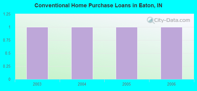
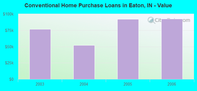
| Home Mortgage Disclosure Act Aggregated Statistics For Year 2009 (Based on 1 partial tract) | ||
| C) Refinancings | ||
|---|---|---|
| Number | Average Value | |
| LOANS ORIGINATED | 1 | $129,100 |
| APPLICATIONS APPROVED, NOT ACCEPTED | 0 | $0 |
| APPLICATIONS DENIED | 1 | $63,980 |
| APPLICATIONS WITHDRAWN | 0 | $0 |
| FILES CLOSED FOR INCOMPLETENESS | 0 | $0 |
Detailed HMDA statistics for the following Tracts: 0026.02
2003 - 2017 National Fire Incident Reporting System (NFIRS) incidents
- Fire incident types reported to NFIRS in Eaton, IN
- 21549.1%Outside Fires
- 16938.6%Structure Fires
- 368.2%Mobile Property/Vehicle Fires
- 184.1%Other
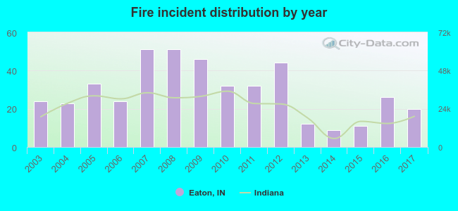 According to the data from the years 2003 - 2017 the average number of fire incidents per year is 29. The highest number of fires - 51 took place in 2007, and the least - 9 in 2014. The data has a declining trend.
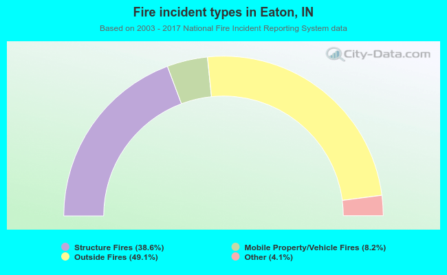 When looking into fire subcategories, the most incidents belonged to: Outside Fires (49.1%), and Structure Fires (38.6%).
| Most common first names in Eaton, IN among deceased individuals | ||
| Name | Count | Lived (average) |
|---|---|---|
| John | 24 | 73.9 years |
| Charles | 21 | 70.0 years |
| William | 21 | 73.3 years |
| Mary | 19 | 79.5 years |
| Robert | 18 | 68.7 years |
| James | 14 | 68.0 years |
| Harry | 11 | 73.0 years |
| Ralph | 11 | 72.6 years |
| George | 10 | 66.0 years |
| Paul | 9 | 65.8 years |
| Most common last names in Eaton, IN among deceased individuals | ||
| Last name | Count | Lived (average) |
|---|---|---|
| Smith | 18 | 75.0 years |
| Clevenger | 8 | 79.4 years |
| Wright | 8 | 71.0 years |
| Wilson | 8 | 71.0 years |
| Robbins | 7 | 82.4 years |
| Morris | 7 | 82.8 years |
| Cooper | 6 | 68.5 years |
| Edwards | 6 | 79.3 years |
| Adams | 6 | 81.5 years |
| Love | 6 | 86.0 years |
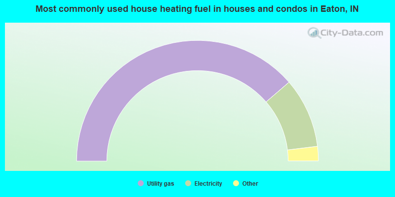
- 77.5%Utility gas
- 18.8%Electricity
- 3.1%Wood
- 0.5%Bottled, tank, or LP gas
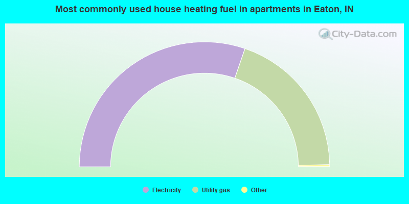
- 60.8%Electricity
- 39.2%Utility gas
Eaton compared to Indiana state average:
- Median house value significantly below state average.
- Unemployed percentage below state average.
- Black race population percentage significantly below state average.
- Foreign-born population percentage significantly below state average.
- Length of stay since moving in significantly above state average.
- House age above state average.
- Percentage of population with a bachelor's degree or higher below state average.

|
Total of 9 patent applications in 2008-2024.