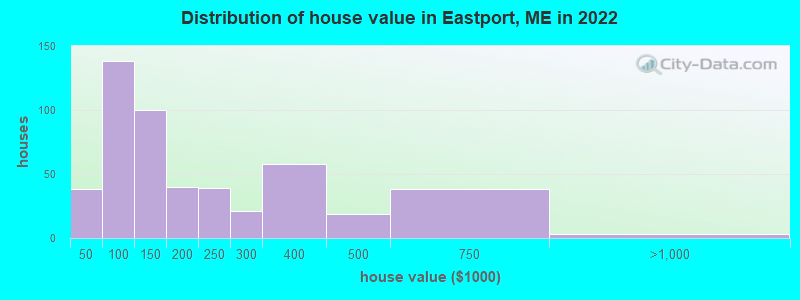
Estimated median house or condo value in 2022: $142,807 (it was $51,100 in 2000)
Eastport:
$142,807
ME:
$290,600
Mean prices in 2022:all housing units: $208,896; detached houses: $229,377; townhouses or other attached units: $190,242; in 2-unit structures: $139,050; in 3-to-4-unit structures: $456,045; in 5-or-more-unit structures: $413,457; mobile homes: $94,515; occupied boats, rvs, vans, etc.: $45,679
Median gross rent in 2022: $448.
March 2022 cost of living index in Eastport: 84.2 (less than average, U.S. average is 100)
Percentage of residents living in poverty in 2022: 12.0%
(10.1% for White Non-Hispanic residents, 41.7% for Black residents, 62.5% for Hispanic or Latino residents, 55.0% for American Indian residents, 11.6% for two or more races residents)
According to our research of Maine and other state lists, there were 2 registered sex offenders living in Eastport, Maine as of May 08, 2024. The ratio of all residents to sex offenders in Eastport is 696 to 1. The ratio of registered sex offenders to all residents in this city is lower than the state average.
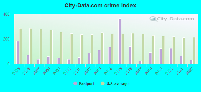
Crime rates in Eastport by year
Type
2009
2010
2011
2012
2013
2014
2015
2016
2017
2018
2019
2020
2021
2022
Murders (per 100,000)
0 (0.0)
0 (0.0)
0 (0.0)
0 (0.0)
0 (0.0)
0 (0.0)
1 (79.5)
0 (0.0)
0 (0.0)
0 (0.0)
0 (0.0)
0 (0.0)
0 (0.0)
0 (0.0)
Rapes (per 100,000)
0 (0.0)
0 (0.0)
0 (0.0)
0 (0.0)
0 (0.0)
1 (77.9)
2 (159.0)
1 (79.7)
0 (0.0)
0 (0.0)
1 (79.9)
0 (0.0)
1 (78.7)
0 (0.0)
Robberies (per 100,000)
0 (0.0)
0 (0.0)
0 (0.0)
0 (0.0)
0 (0.0)
0 (0.0)
0 (0.0)
0 (0.0)
0 (0.0)
0 (0.0)
0 (0.0)
0 (0.0)
0 (0.0)
0 (0.0)
Assaults (per 100,000)
0 (0.0)
0 (0.0)
1 (75.1)
1 (75.6)
3 (230.4)
2 (155.8)
0 (0.0)
3 (239.2)
0 (0.0)
0 (0.0)
2 (159.9)
2 (159.0)
0 (0.0)
2 (156.0)
Burglaries (per 100,000)
6 (393.4)
3 (225.4)
4 (300.5)
9 (680.3)
6 (460.8)
5 (389.4)
4 (318.0)
3 (239.2)
2 (160.9)
12 (953.9)
2 (159.9)
8 (635.9)
0 (0.0)
0 (0.0)
Thefts (per 100,000)
8 (524.6)
7 (525.9)
5 (375.7)
8 (604.7)
9 (691.2)
3 (233.6)
14 (1,113)
4 (319.0)
2 (160.9)
8 (635.9)
5 (399.7)
16 (1,272)
0 (0.0)
0 (0.0)
Auto thefts (per 100,000)
0 (0.0)
0 (0.0)
0 (0.0)
0 (0.0)
1 (76.8)
1 (77.9)
2 (159.0)
0 (0.0)
1 (80.5)
0 (0.0)
0 (0.0)
0 (0.0)
0 (0.0)
0 (0.0)
Arson (per 100,000)
0 (0.0)
0 (0.0)
0 (0.0)
0 (0.0)
0 (0.0)
0 (0.0)
0 (0.0)
0 (0.0)
0 (0.0)
0 (0.0)
0 (0.0)
0 (0.0)
0 (0.0)
0 (0.0)
City-Data.com crime index
48.5
36.8
51.1
86.9
112.1
136.3
365.7
141.1
24.1
92.2
123.1
127.2
63.0
31.2
The City-Data.com crime index weighs serious crimes and violent crimes more heavily. Higher means more crime, U.S. average is 246.1. It adjusts for the number of visitors and daily workers commuting into cities.
Ancestries: American (24.4%), English (17.9%), Irish (9.4%), German (5.5%), Canadian (3.5%), Scottish (3.1%).
Current Local Time: EST time zone
Incorporated on 02/24/1798
Elevation: 150 feet
Land area: 3.66 square miles.
Population density: 355 people per square mile (very low).
27 residents are foreign born (1.5% North America, 0.4% Asia, 0.2% Europe).
This city:
2.2%
Maine:
3.8%
Median real estate property taxes paid for housing units with mortgages in 2022: $2,386 (1.4%) Median real estate property taxes paid for housing units with no mortgage in 2022: $2,259 (1.7%)
Nearest city with pop. 50,000+: Portland, ME (183.3 miles , pop. 64,249).
Nearest city with pop. 200,000+: Boston, MA (272.0 miles , pop. 589,141).
Nearest city with pop. 1,000,000+: Bronx, NY (447.3 miles , pop. 1,332,650).
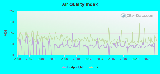
Air Quality Index (AQI) level in 2022 was 44.0. This is significantly better than average.
City:
44.0
U.S.:
72.6
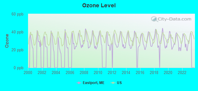
Ozone [ppb] level in 2022 was 28.7. This is about average.Closest monitor was 3.6 miles away from the city center.
City:
28.7
U.S.:
33.3
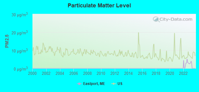
Particulate Matter (PM2.5) [µg/m3] level in 2022 was 3.12. This is significantly better than average.Closest monitor was 4.5 miles away from the city center.
City:
3.12
U.S.:
8.11
Earthquake activity:
Eastport-area historical earthquake activity is above Maine state average. It is 85% smaller than the overall U.S. average.
On 10/16/2012 at 23:12:25, a magnitude 4.7 (4.7 ML, Depth: 10.0 mi, Class: Light, Intensity: IV - V) earthquake occurred 202.5 miles away from the city center On 4/20/2002 at 10:50:47, a magnitude 5.3 (5.3 ML, Depth: 3.0 mi, Class: Moderate, Intensity: VI - VII) earthquake occurred 330.1 miles away from Eastport center On 2/2/2016 at 11:56:22, a magnitude 3.6 (3.6 MB, Depth: 3.1 mi, Class: Light, Intensity: II - III) earthquake occurred 6.8 miles away from the city center On 4/20/2002 at 10:50:47, a magnitude 5.2 (5.2 MB, 4.2 MS, 5.2 MW, 5.0 MW) earthquake occurred 331.3 miles away from the city center On 1/19/1982 at 00:14:42, a magnitude 4.7 (4.5 MB, 4.7 MD, 4.5 LG) earthquake occurred 247.9 miles away from Eastport center On 10/3/2006 at 00:07:38, a magnitude 3.7 (3.7 MD, Depth: 6.2 mi) earthquake occurred 67.8 miles away from Eastport center Magnitude types: regional Lg-wave magnitude (LG), body-wave magnitude (MB), duration magnitude (MD), local magnitude (ML), surface-wave magnitude (MS), moment magnitude (MW)
Natural disasters:
The number of natural disasters in Washington County (20) is greater than the US average (15). Major Disasters (Presidential) Declared: 14 Emergencies Declared: 6
Causes of natural disasters: Floods: 11, Storms: 10, Snows: 5, Winds: 2, Winter Storms: 2, Blizzard: 1, Heavy Rain: 1, Hurricane: 1, Ice Storm: 1, Landslide: 1, Snowfall: 1, Other: 2 (Note: some incidents may be assigned to more than one category).
Hospitals and medical centers in Eastport:
EASTPORT MEMORIAL NURSING HOME (23 BOYNTON STREET)
SUNRISE COUNTY DIALYSIS (19 VANASSE ROAD)
Other hospitals and medical centers near Eastport:
OCEANVIEW NURSING HOME (Nursing Home, about 4 miles away; LUBEC, ME)
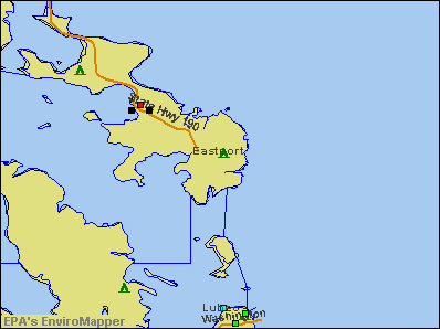
Notable locations in Eastport: The Seaview Campground (A), Eastport Municipal Fire Department Station 1 (B), Eastport Municipal Fire Department Station 2 (C), Barracks Museum (D), Downeast Emergency Medical Services Eastport (E), Washington County Marine Trades Center (F), Peavey Memorial Library (G), Mustard Mill Museum (H). Display/hide their locations on the map
Churches in Eastport include: Cornerstone Baptist Church (A), Episcopal Union Church (B), Blakeley Memorial Methodist Church (C). Display/hide their locations on the map
Parks in Eastport include: Monument Square (1), Eastport Historic District (2), Boynton Street Historic District (3). Display/hide their locations on the map
Hotels: Seaview Campgrounds (16 Norwood Road), The Motel East (23 Water Street # A), Shady Pine Motel & Cabins (Norwood Road), Motel East (23 Water Station).
Birthplace of: Napoleon J.T. Dana - Union Army general, Harry G. Hamlet - Coast Guard Officer and Commandant of the Coast Guard, Helen Ring Robinson - Politician, Kevin Raye - Politician, Edward R. Bowman - Union Navy Medal of Honor recipient, Joseph S. Cony - Navy officer.
Washington County has a predicted average indoor radon screening level between 2 and 4 pCi/L (pico curies per liter) - Moderate Potential
Drinking water stations with addresses in Eastport and their reported violations in the past:
PASSAMAQUODDY WATER DISTRICT (Population served: 1,900, Surface water):
Past health violations:
Treatment Technique (SWTR and GWR) - In JUL-2013. Follow-up actions: St Public Notif requested (AUG-14-2013), St Formal NOV issued (AUG-14-2013), St Public Notif received (AUG-30-2013), St Compliance achieved (AUG-31-2013), St AO (w/o penalty) issued (DEC-20-2013), St BCA signed (FEB-13-2014)
Treatment Technique (SWTR and GWR) - In JUN-2013. Follow-up actions: St Public Notif requested (JUL-22-2013), St Formal NOV issued (JUL-22-2013), St Public Notif received (AUG-19-2013), St Compliance achieved (AUG-31-2013), St AO (w/o penalty) issued (DEC-20-2013), St BCA signed (FEB-13-2014)
Treatment Technique (SWTR and GWR) - In APR-2013. Follow-up actions: St Public Notif requested (MAY-23-2013), St Formal NOV issued (MAY-23-2013), St Public Notif received (JUN-20-2013), St Compliance achieved (AUG-31-2013), St AO (w/o penalty) issued (DEC-20-2013), St BCA signed (FEB-13-2014)
Treatment Technique (SWTR and GWR) - In FEB-2013. Follow-up actions: St Public Notif requested (MAR-11-2013), St Formal NOV issued (MAR-11-2013), St Public Notif received (APR-01-2013), St Compliance achieved (AUG-31-2013), St AO (w/o penalty) issued (DEC-20-2013), St BCA signed (FEB-13-2014)
Treatment Technique (SWTR and GWR) - In JAN-2013. Follow-up actions: St Public Notif requested (FEB-27-2013), St Formal NOV issued (FEB-27-2013), St Public Notif received (MAR-18-2013), St Compliance achieved (AUG-31-2013), St AO (w/o penalty) issued (DEC-20-2013), St BCA signed (FEB-13-2014)
Treatment Technique (SWTR and GWR) - In NOV-2012. Follow-up actions: St Public Notif requested (DEC-21-2012), St Formal NOV issued (DEC-21-2012), St Public Notif received (JAN-24-2013), St Compliance achieved (AUG-31-2013), St AO (w/o penalty) issued (DEC-20-2013), St BCA signed (FEB-13-2014)
22 other older health violations
Past monitoring violations:
Monthly Turbidity Exceed (Enhanced SWTR) - In SEP-2012, Contaminant: IESWTR. Follow-up actions: St Public Notif received (OCT-12-2012), St Public Notif requested (OCT-23-2012), St Formal NOV issued (OCT-23-2012), St Compliance achieved (AUG-31-2013), St AO (w/o penalty) issued (DEC-20-2013), St BCA signed (FEB-13-2014)
Monthly Turbidity Exceed (Enhanced SWTR) - In OCT-2011, Contaminant: IESWTR. Follow-up actions: St Public Notif requested (MAR-16-2012), St Boil Water Order (MAR-16-2012), St Formal NOV issued (MAR-16-2012), St Tech Assistance Visit (MAR-16-2012), St Public Notif received (MAY-18-2012), St Compliance achieved (FEB-27-2013), St AO (w/o penalty) issued (DEC-20-2013), St BCA signed (FEB-13-2014)
Monthly Turbidity Exceed (Enhanced SWTR) - In AUG-2011, Contaminant: IESWTR. Follow-up actions: St Public Notif requested (OCT-25-2011), St Compliance Meeting conducted (OCT-25-2011), St Boil Water Order (OCT-25-2011), St Formal NOV issued (OCT-25-2011), St Public Notif received (OCT-25-2011), St Tech Assistance Visit (OCT-25-2011), St Compliance achieved (FEB-27-2013), St AO (w/o penalty) issued (DEC-20-2013), St BCA signed (FEB-13-2014)
Monitoring, Repeat Major (TCR) - In MAY-2011, Contaminant: Coliform (TCR). Follow-up actions: St Formal NOV issued (MAY-14-2012), St Compliance achieved (MAY-17-2012)
4 routine major monitoring violations
One regular monitoring violation
AOS 77 PEMBROKE ELEMENTARY SCHOOL (Population served: 115, Groundwater):
Past health violations:
MCL, Average - Between JUL-2012 and SEP-2012, Contaminant: Arsenic. Follow-up actions: St Public Notif requested (SEP-28-2012), St Formal NOV issued (SEP-28-2012), St Compliance achieved (MAR-06-2013)
HARRIS POINT SHORE MOTEL & COTTAGES (Population served: 88, Groundwater):
Past health violations:
MCL, Monthly (TCR) - In SEP-2008, Contaminant: Coliform. Follow-up actions: St Public Notif requested (SEP-19-2008), St Formal NOV issued (SEP-19-2008), St Public Notif received (SEP-30-2008), St Compliance achieved (2 times from SEP-07-2011 to SEP-09-2011)
MCL, Monthly (TCR) - In AUG-2007, Contaminant: Coliform. Follow-up actions: St Public Notif requested (SEP-04-2007), St Formal NOV issued (SEP-04-2007), St Public Notif received (OCT-02-2007), St Compliance achieved (2 times from SEP-07-2011 to SEP-09-2011)
MCL, Monthly (TCR) - In JUL-2006, Contaminant: Coliform. Follow-up actions: St Public Notif requested (AUG-07-2006), St Violation/Reminder Notice (AUG-07-2006), St Compliance achieved (2 times from SEP-07-2011 to SEP-09-2011), St Intentional no-action (SEP-15-2011)
Past monitoring violations:
3 routine major monitoring violations
One minor monitoring violation
AOS 77 CHARLOTTE ELEMENTARY SCHOOL (Population served: 62, Groundwater):
Past monitoring violations:
4 routine major monitoring violations
AOS 77 ALEXANDER ELEMENTARY SCHOOL (Population served: 61, Groundwater):
Past health violations:
MCL, Monthly (TCR) - In FEB-2012, Contaminant: Coliform. Follow-up actions: St Public Notif requested (FEB-23-2012), St Formal NOV issued (FEB-23-2012), St Public Notif received (FEB-29-2012), St Compliance achieved (2 times from MAR-12-2012 to MAR-12-2012)
MCL, Monthly (TCR) - In JAN-2012, Contaminant: Coliform. Follow-up actions: St Public Notif requested (FEB-06-2012), St Formal NOV issued (FEB-06-2012), St Public Notif received (FEB-16-2012), St Compliance achieved (2 times from MAR-12-2012 to MAR-12-2012)
MCL, Monthly (TCR) - In NOV-2011, Contaminant: Coliform. Follow-up actions: St Formal NOV issued (DEC-08-2011), St Public Notif requested (DEC-08-2011), St Compliance achieved (2 times from DEC-21-2011 to MAR-12-2012), St Public Notif received (APR-30-2012)
MCL, Monthly (TCR) - In SEP-2011, Contaminant: Coliform. Follow-up actions: St Public Notif requested (SEP-30-2011), St Formal NOV issued (SEP-30-2011), St Public Notif received (OCT-14-2011), St Compliance achieved (2 times from DEC-21-2011 to MAR-12-2012)
MCL, Monthly (TCR) - In OCT-2010, Contaminant: Coliform. Follow-up actions: St Public Notif requested (NOV-01-2010), St Formal NOV issued (NOV-01-2010), St Public Notif received (NOV-09-2010), St Compliance achieved (APR-14-2011)
MCL, Monthly (TCR) - In JUL-2009, Contaminant: Coliform. Follow-up actions: St Public Notif requested (AUG-03-2009), St Formal NOV issued (AUG-03-2009), St Public Notif received (AUG-14-2009), St Compliance achieved (APR-14-2011)
3 other older health violations
Past monitoring violations:
Monitoring, Repeat Major (TCR) - In SEP-2005, Contaminant: Coliform (TCR). Follow-up actions: St Public Notif requested (OCT-19-2005), St Violation/Reminder Notice (OCT-19-2005), St Compliance achieved (NOV-29-2007), St Public Notif received (DEC-12-2007)
Monitoring, Repeat Major (TCR) - In FEB-2005, Contaminant: Coliform (TCR). Follow-up actions: St Public Notif requested (MAR-07-2005), St Violation/Reminder Notice (MAR-07-2005), St Compliance achieved (NOV-29-2007), St Public Notif received (DEC-12-2007)
9 routine major monitoring violations
2 minor monitoring violations
13 regular monitoring violations
Average household size:
This city:
1.9 people
Maine:
2.3 people
Percentage of family households:
This city:
53.0%
Whole state:
62.9%
Percentage of households with unmarried partners:
This city:
6.7%
Whole state:
9.4%
Likely homosexual households (counted as self-reported same-sex unmarried-partner households)
Lesbian couples: 0.4% of all households
Gay men: 0.3% of all households
24 people in nursing facilities/skilled-nursing facilities in 2010
11 people in residential treatment centers for adults in 2010
People in group quarters in Eastport in 2000:
20 people in nursing homes
13 people in homes for the physically handicapped
3 people in other nonhousehold living situations
Banks with branches in Eastport (2011 data):
The First, N.A.: Eastport Branch at 102 Washington Street, branch established on 1990/04/18. Info updated 2010/06/01: Bank assets: $1,338.8 mil, Deposits: $942.2 mil, headquarters in Damariscotta, ME, positive income, Commercial Lending Specialization, 14 total offices, Holding Company: First Bancorp, Inc., The
Bangor Savings Bank: Eastport Branch at 54 Washington Street, branch established on 1869/01/01. Info updated 2008/12/02: Bank assets: $2,556.3 mil, Deposits: $1,940.3 mil, headquarters in Bangor, ME, positive income, Commercial Lending Specialization, 58 total offices, Holding Company: Bangor Bancorp, Mhc
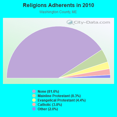
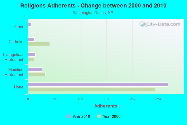
Religion statistics for Eastport, ME (based on Washington County data)
Religion
Adherents
Congregations
Mainline Protestant
2,731
37
Evangelical Protestant
1,442
31
Catholic
1,238
10
Other
648
13
None
26,797
-
Source: Clifford Grammich, Kirk Hadaway, Richard Houseal, Dale E.Jones, Alexei Krindatch, Richie Stanley and Richard H.Taylor. 2012. 2010 U.S.Religion Census: Religious Congregations & Membership Study. Association of Statisticians of American Religious Bodies. Jones, Dale E., et al. 2002. Congregations and Membership in the United States 2000. Nashville, TN: Glenmary Research Center. Graphs represent county-level data


 Recent articles from our blog. Our writers, many of them Ph.D. graduates or candidates, create easy-to-read articles on a wide variety of topics.

 (183.3 miles